
| MILLINOCKET MUNI MILLINOCKET ME |
| |
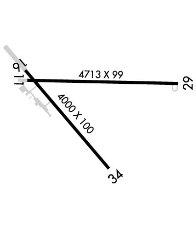
| Lat: N 4538.9 Long: W 06841.1 Elev: 408 Var: +17 Longest Runway: 4713 | ||
| AWOS: 135.22 CTAF: 122.8 | ||
| |||||||||||||||||||||||||||||||||||||||||||||||||||||||||||||
| |||||||||||||||||||||||||||||||||||||||||||||||||||||||||||||
| |||||||||||||||||||||||||||||||||||||||||||||||||||||||||||||
| Rwy | Rwy | |||||||
| 4713x99 | 4713' | 4713x99 | 4713' | 108.90 - 270° | ||||
| 4000x100 | 4000' | 4000x100 | 4000' | |||||
| Runway ID | Single Wheel | Double Wheel | Double Tandem Wheel | Dual Double Wheel |
| 11/29 | 30,000 | 44,000 | N/A | N/A |
| 16/34 | 30,000 | 44,000 | N/A | N/A |
| These numbers are Advisory and are not limits. The Airport Manager should have more accurate Weight Limits | ||||
 Airport Diagram might not be current. | |
| Facility Name: | MILLINOCKET MUNI |
| City Name: | MILLINOCKET |
| County: | PENOBSCOT |
| State abbrev: | ME |
| State Name: | MAINE |
| Ownership: | PUBLICLY OWNED |
| Use: | OPEN TO THE PUBLIC |
| Owner's Name: | TOWN OF MILLINOCKET |
| Address: | 197 PENOBSCOT AVE |
| MILLINOCKET, ME 04462 | |
| Owner's Phone: | 207-723-6649 |
| Manager's Name: | JEFF CAMPBELL |
| Address: | MILLINOCKET MUNICIPAL ARPT, 271 MEDWAY ROAD |
| MILLINOCKET, ME 04462 | |
| Phone: | 207-723-6649 |
| FAA Region: | NEW ENGLAND |
| FAA Field Office: | NONE |
| Date | Sunrise | Sunset |
|---|---|---|
| 06/08/26 Monday | 4:46 | 20:22 |
| 06/09/26 Tuesday | 4:46 | 20:23 |
| 06/10/26 Wednesday | 4:45 | 20:23 |
| 06/11/26 Thursday | 4:45 | 20:24 |
| 06/12/26 Friday | 4:45 | 20:24 |
| 06/13/26 Saturday | 4:45 | 20:25 |
| 06/14/26 Sunday | 4:45 | 20:25 |
| 06/15/26 Monday | 4:45 | 20:26 |
| 06/16/26 Tuesday | 4:45 | 20:26 |
| 06/17/26 Wednesday | 4:45 | 20:27 |
| 06/18/26 Thursday | 4:45 | 20:27 |
| 06/19/26 Friday | 4:45 | 20:27 |
| 06/20/26 Saturday | 4:45 | 20:27 |
| 06/21/26 Sunday | 4:45 | 20:28 |
| Airport Attendance Schedule | MAY-NOV MON-FRI 0800-1600, DEC-APR MON-FRI 0800-1600, DEC-APR SAT-SUN UNATNDD, MAY-NOV SAT-SUN 0800-1600 |
| Airport Status | OPERATIONAL (This Status can change at any time - please check NOTAMS) |
| Airport Lighting Schedule | ACTVT REIL RWY 29; VASI RWY 29; MIRL RWY 11/29 - CTAF. |
| Airport Storage Available | Tie Downs, Hanger |
| Extra Services Available | Flight Instruction, Parachute Jumping |
| Wind Indicator | YES - (lighted) |
| Control Tower | NO |
| CTAF Frequency | 122.800 |
| Unicom Frequency | 122.800 |
| Rotating Beacon Color | WG |
| Segmented Circle | NO |
| Landing Fee | NO |
| Airport Inspected | STATE - performed by PRIVATE CONTRACT PERSONNEL |
| Inspection Date | 08/21/2024 |
| Type of Fuel Available | Grade 100LL, JET A (freeze point -40C); -10FUEL AVBL 24 HRS WITH CREDIT CARD. JET A AVBL AFT HRS 207-723-4375 OR 207-723-6649. |
| Airframe Repair Service | NONE |
| Power Plant Repair Service | NONE |
| Latitude | N4538.9 |
| Longitude | W06841.1 (ESTIMATED) |
| Arpt Elevation | 408ft (SURVEYED) |
| Magnetic Variation | 17W |
| 1 miles SE | of MILLINOCKET |
| Traffic Pattern Altitude | |
| Sectional Chart | HALIFAX |
| Operations (Reported) | Yearly | Avg. Daily |
|---|---|---|
| General Aviation Transient | 0 | 0 |
| General Aviation Local | 0 | 0 |
| Air Taxi | 0 | 0 |
| Commerical | 0 | 0 |
| Commuter | 0 | 0 |
| Military | 0 | 0 |
| Aircraft based on Field | |
|---|---|
| General Aviation Singles | 0 |
| General Aviation Multi | 0 |
| Jet Aircraft | 0 |
| General Aviation Helicopters | 0 |
| Military Aircraft | 0 |
| Gliders | 0 |
| Ultralights | 0 |
| FSS on field | NO |
| FSS tie-in | BANGOR |
| FSS Phone | 1-800-WX-BRIEF |
| Who issues Notams | MLT |
| Notam D service at airport | YES |
| ARTCC Name | BOSTON |
| Airport Certification | |
| Aircraft Rescue & Firefighting Index | None |
| Airport of Entry | No |
| Custom Landing Rights | No |
| Joint Civil/Military | No |
| Military Landing rights | YES |
| NATIONAL PLAN OF INTEGRATED AIRPORT SYSTEMS (NPIAS) |
| GRANT AGREEMENTS UNDER FAAP/ADAP/AIP |
| ASSURANCES PURSUANT TO TITLE VI, CIVIL RIGHTS ACT OF 1964 |
| AGREEMENT UNDER DLAND OR DCLA HAS EXPIRED. |
| FOR CD IF UNA TO CTC ON FSS FREQ, CTC BOSTON ARTCC AT 603-879-6859 . |
| WILDLIFE ON AND INVOF ARPT. |
| +782 FT MSL COM/AIR QLTY MNT TWR LCTD APRXLY 5200 FT FM THR OF RWY 11 AT 247 DEGS. |
Airport Communications & Frequencies:
| |||||||||
| Runway: 11 | Runway: 29 | ||
| Mag heading: | 107° | Mag heading: | 287° |
| Rwy Slope: | -.12% Down | Rwy Slope: | .12% Up |
| Approach: | Approach: | LOCALIZER | |
| Pattern: | Left Traffic | Pattern: | Left Traffic |
| Markings: | NONPRECISION INSTRUMENT | Markings: | NONPRECISION INSTRUMENT |
| Marking Condition: | POOR; FADED. | Marking Condition: | POOR; FADED. |
| Arresting Dev: | Arresting Dev: | ||
| Lat & Long: | N4539.0 W06841.6 | Lat. & Long.: | N4539.0 W06840.5 |
| Elev: | 400.9 ft. MSL | Elev: | 395.1 ft. MSL |
| TCH: | TCH: | 51 ft. AGL | |
| Visual Glide Path: | Visual Glide Path: | 3.00 degrees | |
| Displaced Threshold: | No | Displaced Threshold: | No |
| Touchdown Zone: | YES | Touchdown Zone: | YES |
| Touchdown Elev.: | 408.1 feet | Touchdown Elev.: | 408.1 feet |
| Visual Glide Slope: | Visual Glide Slope: | 4-BOX VASI ON RIGHT SIDE OF RUNWAY | |
| RVR Equipment: | RVR Equipment: | ||
| RVV Equipment: | NO | RVV Equipment: | NO |
| Approach Lights: | Approach Lights: | ||
| REIL: | NO | REIL: | YES |
| Centerline Lights: | NO | Centerline Lights: | NO |
| Touchdown lights: | NO | Touchdown lights: | NO |
| Runway Category: | Runway with a Non-precision Approach having visibility minimums greater than 3/4 mile | Runway Category: | Runway with a Non-precision Approach having visibility minimums greater than 3/4 mile |
| Declared Distances: | Declared Distances: | ||
| Obstructions: | BLDG | Obstructions: | |
| Marked: | LIGHTED | Marked: | |
| Clearance slope: | 9:1 | Clearance slope: | 34:1 |
| Obstruction height: | 27 feet AGL | Obstruction height: | |
| Dist. from runway: | 465 feet | Dist. from runway: | |
| Centerline offset: | 240 right of centerline | Centerline offset: | |
| Comments: | Comments: | 8 FT BRUSH, 30-110 FT FM THR, 130-250 FT L OF CNTRLN. |
| Runway: 16 | Runway: 34 | ||
| Mag heading: | 156° | Mag heading: | 336° |
| Rwy Slope: | -.51% Down | Rwy Slope: | .51% Up |
| Approach: | Approach: | ||
| Pattern: | Left Traffic | Pattern: | Left Traffic |
| Markings: | BASIC | Markings: | BASIC |
| Marking Condition: | POOR; FADED. | Marking Condition: | POOR; FADED. |
| Arresting Dev: | Arresting Dev: | ||
| Lat & Long: | N4539.0 W06841.6 | Lat. & Long.: | N4538.5 W06841.0 |
| Elev: | 400.3 ft. MSL | Elev: | 379.9 ft. MSL |
| TCH: | TCH: | ||
| Visual Glide Path: | Visual Glide Path: | ||
| Displaced Threshold: | No | Displaced Threshold: | No |
| Touchdown Zone: | YES | Touchdown Zone: | YES |
| Touchdown Elev.: | 401.1 feet | Touchdown Elev.: | 400.8 feet |
| Visual Glide Slope: | Visual Glide Slope: | ||
| RVR Equipment: | RVR Equipment: | ||
| RVV Equipment: | NO | RVV Equipment: | NO |
| Approach Lights: | Approach Lights: | ||
| REIL: | NO | REIL: | NO |
| Centerline Lights: | NO | Centerline Lights: | NO |
| Touchdown lights: | NO | Touchdown lights: | NO |
| Runway Category: | Runway with a Visual Approach | Runway Category: | Runway with a Visual Approach |
| Declared Distances: | Declared Distances: | ||
| Obstructions: | TREES | Obstructions: | ROAD |
| Marked: | NOT Marked/Lighted | Marked: | NOT Marked/Lighted |
| Clearance slope: | 19:1 | Clearance slope: | 3:1 |
| Obstruction height: | 51 feet AGL | Obstruction height: | 15 feet AGL |
| Dist. from runway: | 1180 feet | Dist. from runway: | 255 feet |
| Centerline offset: | 45 right of centerline | Centerline offset: | 130 feet left of centerline |
| Comments: | Comments: |
Thanks for using FltPlan.com
all rights reserved © 1999-2026 by Flight Plan LLC

