| FRANK WILEY FIELD MILES CITY MT |
| |
| Lat: N 4625.6 Long: W 10553.3 Elev: 2634 Var: -09 Longest Runway: 5764 | ||
| AWOS: 135.57 CTAF: 123.0 | ||
| ||||||||||||||||||||||||||||||||||||||||||||||||||||||||||||||||||||
| ||||||||||||||||||||||||||||||||||||||||||||||||||||||||||||||||||||
| ||||||||||||||||||||||||||||||||||||||||||||||||||||||||||||||||||||
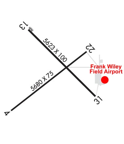
| Rwy | Rwy | |||||||
| 5764x75 | 5764' | 5764x75 | 5764' | |||||
| 5624x100 | 5624' | 5624x100 | 5624' | |||||
| Runway ID | Single Wheel | Double Wheel | Double Tandem Wheel | Dual Double Wheel |
| 04/22 | 24,000 | 24,000 | N/A | N/A |
| 13/31 | 38,000 | 55,000 | 85,000 | N/A |
| These numbers are Advisory and are not limits. The Airport Manager should have more accurate Weight Limits | ||||
 Airport Diagram might not be current. | |
| Facility Name: | FRANK WILEY FLD |
| City Name: | MILES CITY |
| County: | CUSTER |
| State abbrev: | MT |
| State Name: | MONTANA |
| Ownership: | PUBLICLY OWNED |
| Use: | OPEN TO THE PUBLIC |
| Owner's Name: | MILES CITY |
| Address: | PO BOX 910, 77 FRANK WILEY FIELD |
| MILES CITY, MT 59301 | |
| Owner's Phone: | 406-874-8602 |
| Manager's Name: | BRAD DAVIS |
| Address: | PO BOX 910, 77 FRANK WILEY FIELD |
| MILES CITY, MT 59301 | |
| Phone: | 406-951-0955 |
| FAA Region: | NORTHWEST MOUNTAIN |
| FAA Field Office: | HLN |

| Date | Sunrise | Sunset |
|---|---|---|
| 06/08/26 Monday | 5:11 | 20:54 |
| 06/09/26 Tuesday | 5:11 | 20:55 |
| 06/10/26 Wednesday | 5:11 | 20:55 |
| 06/11/26 Thursday | 5:11 | 20:56 |
| 06/12/26 Friday | 5:11 | 20:56 |
| 06/13/26 Saturday | 5:10 | 20:57 |
| 06/14/26 Sunday | 5:10 | 20:57 |
| 06/15/26 Monday | 5:10 | 20:58 |
| 06/16/26 Tuesday | 5:10 | 20:58 |
| 06/17/26 Wednesday | 5:10 | 20:59 |
| 06/18/26 Thursday | 5:10 | 20:59 |
| 06/19/26 Friday | 5:10 | 20:59 |
| 06/20/26 Saturday | 5:11 | 21:00 |
| 06/21/26 Sunday | 5:11 | 21:00 |
| Airport Attendance Schedule | 7 Days A Week DALGT |
| Airport Status | OPERATIONAL (This Status can change at any time - please check NOTAMS) |
| Airport Lighting Schedule | ACTVT REIL RWY 04, 13, 22, & 31; PAPI RWY 04, 13, 22, & 31; MIRL RWY 04/22 & RWY 13/31 - CTAF. |
| Airport Storage Available | Tie Downs, Hanger |
| Extra Services Available | NONE |
| Wind Indicator | YES - (lighted) |
| Control Tower | NO |
| CTAF Frequency | 123.000 |
| Unicom Frequency | 123.000 |
| Rotating Beacon Color | WG |
| Segmented Circle | YES |
| Landing Fee | NO |
| Airport Inspected | STATE - performed by STATE AERONAUTICAL PERSONNEL |
| Inspection Date | 07/17/2025 |
| Type of Fuel Available | Grade 100LL, JET A (freeze point -40C); -10AFT HR - 406-234-1296 OR 406-951-0955. |
| Airframe Repair Service | None |
| Power Plant Repair Service | None |
| Latitude | N4625.6 |
| Longitude | W10553.3 (ESTIMATED) |
| Arpt Elevation | 2634ft (SURVEYED) |
| Magnetic Variation | 09E |
| 2 miles NW | of MILES CITY |
| Traffic Pattern Altitude | |
| Sectional Chart | BILLINGS |
| Operations (Reported) | Yearly | Avg. Daily |
|---|---|---|
| General Aviation Transient | 0 | 0 |
| General Aviation Local | 0 | 0 |
| Air Taxi | 0 | 0 |
| Commerical | 0 | 0 |
| Commuter | 0 | 0 |
| Military | 0 | 0 |
| Aircraft based on Field | |
|---|---|
| General Aviation Singles | 0 |
| General Aviation Multi | 0 |
| Jet Aircraft | 0 |
| General Aviation Helicopters | 0 |
| Military Aircraft | 0 |
| Gliders | 0 |
| Ultralights | 0 |
| FSS on field | NO |
| FSS tie-in | GREAT FALLS |
| FSS Phone | 1-800-WX-BRIEF |
| Who issues Notams | MLS |
| Notam D service at airport | YES |
| ARTCC Name | SALT LAKE CITY |
| Airport Certification | |
| Aircraft Rescue & Firefighting Index | None |
| Airport of Entry | No |
| Custom Landing Rights | No |
| Joint Civil/Military | No |
| Military Landing rights | YES |
| NATIONAL PLAN OF INTEGRATED AIRPORT SYSTEMS (NPIAS) |
| GRANT AGREEMENTS UNDER FAAP/ADAP/AIP |
| ASSURANCES PURSUANT TO TITLE VI, CIVIL RIGHTS ACT OF 1964 |
| AGREEMENT UNDER DLAND OR DCLA HAS EXPIRED. |
| TRNG ACT WI 15 MI. BIRDS INVOF ARPT. |
| COND UNMNT - AMGR. |
| FOR CD IF UNA TO CTC ON FSS FREQ, CTC SALT LAKE ARTCC AT 801-320-2568. |
Airport Communications & Frequencies:
| |||||||||
| Runway: 04 | Runway: 22 | ||
| Mag heading: | 43° | Mag heading: | 223° |
| Rwy Slope: | -.15% Down | Rwy Slope: | .15% Up |
| Approach: | Approach: | ||
| Pattern: | Left Traffic | Pattern: | Left Traffic |
| Markings: | NONPRECISION INSTRUMENT | Markings: | NONPRECISION INSTRUMENT |
| Marking Condition: | GOOD | Marking Condition: | GOOD |
| Arresting Dev: | Arresting Dev: | ||
| Lat & Long: | N4625.2 W10554.0 | Lat. & Long.: | N4625.8 W10553.0 |
| Elev: | 2634.1 ft. MSL | Elev: | 2625.2 ft. MSL |
| TCH: | 38 ft. AGL | TCH: | 41 ft. AGL |
| Visual Glide Path: | 3.00 degrees | Visual Glide Path: | 3.00 degrees |
| Displaced Threshold: | No | Displaced Threshold: | No |
| Touchdown Zone: | YES | Touchdown Zone: | YES |
| Touchdown Elev.: | 2634.1 feet | Touchdown Elev.: | 2629.9 feet |
| Visual Glide Slope: | 2-Light PAPI on LEFT side of Runway | Visual Glide Slope: | 2-Light PAPI on LEFT side of Runway |
| RVR Equipment: | RVR Equipment: | ||
| RVV Equipment: | NO | RVV Equipment: | NO |
| Approach Lights: | Approach Lights: | ||
| REIL: | YES | REIL: | YES |
| Centerline Lights: | NO | Centerline Lights: | NO |
| Touchdown lights: | NO | Touchdown lights: | NO |
| Runway Category: | Runway with a Non-precision Approach having visibility minimums greater than 3/4 mile | Runway Category: | Runway with a Non-precision Approach having visibility minimums greater than 3/4 mile |
| Declared Distances: | TORA:5764' TODA:5764' ASDA:5764' LDA:5764' | Declared Distances: | TORA:5764' TODA:5764' ASDA:5764' LDA:5764' |
| Obstructions: | Obstructions: | ROAD | |
| Marked: | Marked: | NOT Marked/Lighted | |
| Clearance slope: | 34:1 | Clearance slope: | 34:1 |
| Obstruction height: | Obstruction height: | 17 feet AGL | |
| Dist. from runway: | Dist. from runway: | 778 feet | |
| Centerline offset: | Centerline offset: | ||
| Comments: | Comments: |
| Runway: 13 | Runway: 31 | ||
| Mag heading: | 126° | Mag heading: | 306° |
| Rwy Slope: | -.08% Down | Rwy Slope: | .08% Up |
| Approach: | Approach: | ||
| Pattern: | Left Traffic | Pattern: | Left Traffic |
| Markings: | NONPRECISION INSTRUMENT | Markings: | NONPRECISION INSTRUMENT |
| Marking Condition: | GOOD | Marking Condition: | GOOD |
| Arresting Dev: | Arresting Dev: | ||
| Lat & Long: | N4626.1 W10553.6 | Lat. & Long.: | N4625.4 W10552.6 |
| Elev: | 2630.0 ft. MSL | Elev: | 2625.6 ft. MSL |
| TCH: | 43 ft. AGL | TCH: | 43 ft. AGL |
| Visual Glide Path: | 3.00 degrees | Visual Glide Path: | 3.00 degrees |
| Displaced Threshold: | No | Displaced Threshold: | No |
| Touchdown Zone: | YES | Touchdown Zone: | YES |
| Touchdown Elev.: | 2630.2 feet | Touchdown Elev.: | 2626.9 feet |
| Visual Glide Slope: | 2-Light PAPI on LEFT side of Runway | Visual Glide Slope: | 2-Light PAPI on LEFT side of Runway |
| RVR Equipment: | RVR Equipment: | ||
| RVV Equipment: | NO | RVV Equipment: | NO |
| Approach Lights: | Approach Lights: | ||
| REIL: | YES | REIL: | YES |
| Centerline Lights: | NO | Centerline Lights: | NO |
| Touchdown lights: | NO | Touchdown lights: | NO |
| Runway Category: | Runway with a Visual Approach | Runway Category: | Runway with a Visual Approach |
| Declared Distances: | TORA:5624' TODA:5624' ASDA:5624' LDA:5624' | Declared Distances: | TORA:5624' TODA:5624' ASDA:5624' LDA:5624' |
Thanks for using FltPlan.com
all rights reserved © 1999-2026 by Flight Plan LLC