| QUAD CITY INTL MOLINE IL |
| |
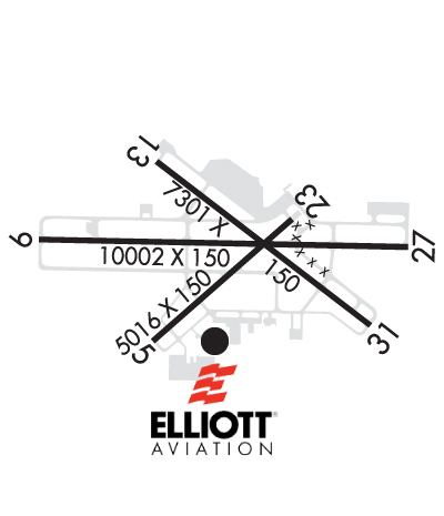
| Lat: N 4126.9 Long: W 09030.5 Elev: 590 Var: -01 Longest Runway: 10002 | ||
| Clr Del: 124.05 Dept. ATIS: 121.2 Arr. ATIS: 121.2 AWOS: 121.2 Ground: 121.9 Tower: 119.4 | ||
| |||||||||||||||||||||||||||||||||||||||||||||||||||||||||||||||||||||
| |||||||||||||||||||||||||||||||||||||||||||||||||||||||||||||||||||||
| |||||||||||||||||||||||||||||||||||||||||||||||||||||||||||||||||||||
| |||||||||||||||||||||||||||||||||||||||||||||||||||||||||||||||||||||
| Rwy | Rwy | |||||||
| 3514x150 | 3514' | 3514x150 | 3514' | |||||
| 10002x150 | 10002' | 110.50 - 090° | 10002x150 | 10002' | 110.50 - 270° | |||
| 7301x150 | 7301' | 7301x150 | 6779' | |||||
| Runway ID | Single Wheel | Double Wheel | Double Tandem Wheel | Dual Double Wheel |
| 05/23 | 92,000 | 114,000 | 193,000 | N/A |
| 09/27 | 120,000 | 229,000 | 369,000 | 850,000 |
| 13/31 | 120,000 | 185,000 | 301,000 | 721,000 |
| These numbers are Advisory and are not limits. The Airport Manager should have more accurate Weight Limits | ||||
 Airport Diagram might not be current. | |
| Facility Name: | QUAD CITIES INTL |
| City Name: | MOLINE |
| County: | ROCK ISLAND |
| State abbrev: | IL |
| State Name: | ILLINOIS |
| Ownership: | PUBLICLY OWNED |
| Use: | OPEN TO THE PUBLIC |
| Owner's Name: | METROPOLITAN AIRPORT AUTH |
| Address: | 2200 GEORGE KIRK DR.; SUITE 100 |
| MOLINE, IL 61265 | |
| Owner's Phone: | 309-757-1768 |
| Manager's Name: | BENJAMIN LEISCHNER |
| Address: | 2200 GEORGE KIRK DR.; SUITE 100 |
| MOLINE, IL 61265 | |
| Phone: | 309-757-1768 |
| FAA Region: | GREAT LAKES |
| FAA Field Office: | CHI |
| Date | Sunrise | Sunset |
|---|---|---|
| 06/08/26 Monday | 5:28 | 20:34 |
| 06/09/26 Tuesday | 5:28 | 20:34 |
| 06/10/26 Wednesday | 5:28 | 20:35 |
| 06/11/26 Thursday | 5:28 | 20:36 |
| 06/12/26 Friday | 5:28 | 20:36 |
| 06/13/26 Saturday | 5:28 | 20:36 |
| 06/14/26 Sunday | 5:28 | 20:37 |
| 06/15/26 Monday | 5:28 | 20:37 |
| 06/16/26 Tuesday | 5:28 | 20:38 |
| 06/17/26 Wednesday | 5:28 | 20:38 |
| 06/18/26 Thursday | 5:28 | 20:38 |
| 06/19/26 Friday | 5:28 | 20:39 |
| 06/20/26 Saturday | 5:28 | 20:39 |
| 06/21/26 Sunday | 5:28 | 20:39 |
| Airport Attendance Schedule | CONTINUOUS |
| Airport Status | OPERATIONAL (This Status can change at any time - please check NOTAMS) |
| Airport Lighting Schedule | WHEN ATCT CLSD ACTVT AND INCR INTS RWY & TWY LIGHTING, MALSR RWY 9 & RWY 27; REIL RWY 13 & RWY 31 - CTAF. |
| Airport Storage Available | Tie Downs, Hanger |
| Extra Services Available | Avionics, Cargo Handling, Charter, Flight Instruction |
| Wind Indicator | YES - (lighted) |
| Control Tower | YES |
| CTAF Frequency | 119.400 |
| Unicom Frequency | 122.950 |
| Rotating Beacon Color | WG |
| Segmented Circle | YES |
| Landing Fee | YES; LDG FEES FOR TSNT ACFT 12,500 LBS AND GTR. |
| Airport Inspected | FEDERAL - performed by FAA AIRPORTS FIELD PERSONNEL |
| Inspection Date | 04/07/2026 |
| Type of Fuel Available | Grade 100LL, JET A (freeze point -40C); -10100LL SELF SERVE FUEL PUMP LCTD IN T-HNGR AREA AND OPEN 24 HRS A DAY. |
| Airframe Repair Service | MAJOR |
| Power Plant Repair Service | MAJOR |
| Latitude | N4126.9 |
| Longitude | W09030.5 (ESTIMATED) |
| Arpt Elevation | 589ft (SURVEYED) |
| Magnetic Variation | 01E |
| 3 miles S | of MOLINE |
| Traffic Pattern Altitude | |
| Sectional Chart | CHICAGO |
| Operations (Reported) | Yearly | Avg. Daily |
|---|---|---|
| General Aviation Transient | 0 | 0 |
| General Aviation Local | 0 | 0 |
| Air Taxi | 0 | 0 |
| Commerical | 0 | 0 |
| Commuter | 0 | 0 |
| Military | 0 | 0 |
| Aircraft based on Field | |
|---|---|
| General Aviation Singles | 0 |
| General Aviation Multi | 0 |
| Jet Aircraft | 0 |
| General Aviation Helicopters | 0 |
| Military Aircraft | 0 |
| Gliders | 0 |
| Ultralights | 0 |
| FSS on field | NO |
| FSS tie-in | KANKAKEE |
| FSS Phone | 1-800-WX-BRIEF |
| Who issues Notams | MLI |
| Notam D service at airport | YES |
| ARTCC Name | CHICAGO |
| Airport Certification | AIRPORT RECEIVING SCHEDULED AIR CARRIER SERVICE FROM CARRIERS CERTIFICATED BY THE CIVIL AERONAUTICS BOARD; ARFF INDEX C AVBL ON REQ; 24 HR PPR CALL AMGR (309) 757-1739 |
| Aircraft Rescue & Firefighting Index | AIRPORT HAS A CERTIFICATE UNDER CFR PART 139 |
| Airport of Entry | No |
| Custom Landing Rights | YES |
| Joint Civil/Military | No |
| Military Landing rights | YES |
| NATIONAL PLAN OF INTEGRATED AIRPORT SYSTEMS (NPIAS) |
| GRANT AGREEMENTS UNDER FAAP/ADAP/AIP |
| ASSURANCES PURSUANT TO TITLE VI, CIVIL RIGHTS ACT OF 1964 |
| BIRDS & MIGRATORY FOWL ON & INVOF ARPT. |
| RWY 05/2 3 PCR VALUE: 350/R/C/W/T |
| RWY 09/2 7 PCR VALUE: 750/R/C/W/T |
| RWY 13/3 1 PCR VALUE: 590/R/C/W/T |
Airport Communications & Frequencies:
| |||||||||||||||||||||||||||||||||||||||||
| Runway: 05 | Runway: 23 | ||
| Mag heading: | 48° | Mag heading: | 228° |
| Rwy Slope: | .15% Up | Rwy Slope: | -.15% Down |
| Approach: | Approach: | ||
| Pattern: | Left Traffic | Pattern: | Left Traffic |
| Markings: | BASIC | Markings: | BASIC |
| Marking Condition: | FAIR | Marking Condition: | FAIR |
| Arresting Dev: | Arresting Dev: | ||
| Lat & Long: | N4126.5 W09030.9 | Lat. & Long.: | N4126.9 W09030.4 |
| Elev: | 578.1 ft. MSL | Elev: | 583.3 ft. MSL |
| TCH: | 46 ft. AGL | TCH: | 41 ft. AGL |
| Visual Glide Path: | 4.00 degrees | Visual Glide Path: | 3.00 degrees |
| Displaced Threshold: | No | Displaced Threshold: | No |
| Touchdown Zone: | YES | Touchdown Zone: | YES |
| Touchdown Elev.: | 583.0 feet | Touchdown Elev.: | 583.3 feet |
| Visual Glide Slope: | 4-Light PAPI on LEFT side of Runway | Visual Glide Slope: | 4-Light PAPI on LEFT side of Runway |
| RVR Equipment: | RVR Equipment: | ||
| RVV Equipment: | NO | RVV Equipment: | NO |
| Approach Lights: | Approach Lights: | ||
| REIL: | NO | REIL: | NO |
| Centerline Lights: | NO | Centerline Lights: | NO |
| Touchdown lights: | NO | Touchdown lights: | NO |
| Runway Category: | Runway with a Visual Approach | Runway Category: | Runway with a Visual Approach |
| Declared Distances: | TORA:3514' TODA:3514' ASDA:3514' LDA:3514' | Declared Distances: | TORA:3514' TODA:3514' ASDA:3514' LDA:3514' |
| Runway: 09 | Runway: 27 | ||
| Mag heading: | 90° | Mag heading: | 270° |
| Rwy Slope: | -.04% Down | Rwy Slope: | .04% Up |
| Approach: | ILS/DME | Approach: | ILS/DME |
| Pattern: | Left Traffic | Pattern: | Left Traffic |
| Markings: | PRECISION INSTRUMENT | Markings: | PRECISION INSTRUMENT |
| Marking Condition: | GOOD | Marking Condition: | GOOD |
| Arresting Dev: | Arresting Dev: | ||
| Lat & Long: | N4127.0 W09031.6 | Lat. & Long.: | N4126.9 W09029.4 |
| Elev: | 577.6 ft. MSL | Elev: | 573.8 ft. MSL |
| TCH: | 50 ft. AGL | TCH: | 52 ft. AGL |
| Visual Glide Path: | 3.00 degrees | Visual Glide Path: | 3.00 degrees |
| Displaced Threshold: | No | Displaced Threshold: | No |
| Touchdown Zone: | YES | Touchdown Zone: | YES |
| Touchdown Elev.: | 586.6 feet | Touchdown Elev.: | 580.8 feet |
| Visual Glide Slope: | 4-Light PAPI on LEFT side of Runway | Visual Glide Slope: | 4-Light PAPI on LEFT side of Runway |
| RVR Equipment: | TOUCHDOWN-ROLLOUT | RVR Equipment: | TOUCHDOWN-ROLLOUT |
| RVV Equipment: | NO | RVV Equipment: | NO |
| Approach Lights: | MALSR - 1,400 foot medium intensity approach lighting system with runway alignment indicator lights | Approach Lights: | MALSR - 1,400 foot medium intensity approach lighting system with runway alignment indicator lights |
| REIL: | NO | REIL: | NO |
| Centerline Lights: | NO | Centerline Lights: | NO |
| Touchdown lights: | NO | Touchdown lights: | NO |
| Runway Category: | Precision Instrument Runway | Runway Category: | Precision Instrument Runway |
| Declared Distances: | TORA:10002' TODA:10002' ASDA:10002' LDA:10002' | Declared Distances: | TORA:10002' TODA:10002' ASDA:10002' LDA:10002' |
| Obstructions: | Obstructions: | TREE | |
| Marked: | Marked: | NOT Marked/Lighted | |
| Clearance slope: | 50:1 | Clearance slope: | 42:1 |
| Obstruction height: | Obstruction height: | 207 feet AGL | |
| Dist. from runway: | Dist. from runway: | 8959 feet | |
| Centerline offset: | Centerline offset: | 1743 feet left of centerline | |
| Comments: | Comments: |
| Runway: 13 | Runway: 31 | ||
| Mag heading: | 126° | Mag heading: | 306° |
| Rwy Slope: | -.05% Down | Rwy Slope: | .05% Up |
| Approach: | Approach: | ||
| Pattern: | Left Traffic | Pattern: | Left Traffic |
| Markings: | NONPRECISION INSTRUMENT | Markings: | NONPRECISION INSTRUMENT |
| Marking Condition: | GOOD | Marking Condition: | GOOD |
| Arresting Dev: | Arresting Dev: | ||
| Lat & Long: | N4127.3 W09030.9 | Lat. & Long.: | N4126.6 W09029.7 |
| Elev: | 584.7 ft. MSL | Elev: | 580.9 ft. MSL |
| TCH: | 45 ft. AGL | TCH: | 45 ft. AGL |
| Visual Glide Path: | 3.00 degrees | Visual Glide Path: | 3.00 degrees |
| Displaced Threshold: | No | Displaced Threshold: | 522 feet |
| Touchdown Zone: | YES | Touchdown Zone: | YES |
| Touchdown Elev.: | 589.6 feet | Touchdown Elev.: | 582.8 feet |
| Visual Glide Slope: | 4-Light PAPI on LEFT side of Runway | Visual Glide Slope: | 4-Light PAPI on LEFT side of Runway |
| RVR Equipment: | RVR Equipment: | ||
| RVV Equipment: | NO | RVV Equipment: | NO |
| Approach Lights: | Approach Lights: | ||
| REIL: | YES | REIL: | YES |
| Centerline Lights: | NO | Centerline Lights: | NO |
| Touchdown lights: | NO | Touchdown lights: | NO |
| Runway Category: | Runway with a Non-precision Approach having visibility minimums greater than 3/4 mile | Runway Category: | Runway with a Non-precision Approach having visibility minimums greater than 3/4 mile |
| Declared Distances: | TORA:7301' TODA:7301' ASDA:7032' LDA:7032' | Declared Distances: | TORA:7301' TODA:7301' ASDA:6954' LDA:6432' |
| Obstructions: | TREE | Obstructions: | TREE |
| Marked: | NOT Marked/Lighted | Marked: | NOT Marked/Lighted |
| Clearance slope: | 32:1 | Clearance slope: | 30:1; 140 FT PWR POLE DIST 5836 FT; 415 FT R; 41:1 BASED ON DSPLCD THLD. |
| Obstruction height: | 45 feet AGL | Obstruction height: | 173 feet AGL |
| Dist. from runway: | 1665 feet | Dist. from runway: | 5522 feet |
| Centerline offset: | 271 right of centerline | Centerline offset: | 559 feet left of centerline |
| Comments: | Comments: |
Thanks for using FltPlan.com
all rights reserved © 1999-2026 by Flight Plan LLC