
| DAVIS FIELD MUSKOGEE OK |
| |
| Lat: N 3539.5 Long: W 09521.7 Elev: 612 Var: -06 Longest Runway: 7202 | ||
| AWOS: 135.02 CTAF: 122.8 | ||
| ||||||||||||||||||||||||||||||||||||||||||||
| ||||||||||||||||||||||||||||||||||||||||||||
| ||||||||||||||||||||||||||||||||||||||||||||
| Rwy | Rwy | |||||||
| 4498x75 | 4498' | 4498x75 | 4498' | |||||
| 7202x150 | 7202' | 7202x150 | 7202' | |||||
| 1904x60 | 1904' | 1904x60 | 1904' | |||||
| Runway ID | Single Wheel | Double Wheel | Double Tandem Wheel | Dual Double Wheel |
| 04/22 | N/A | N/A | N/A | N/A |
| 13/31 | 59,000 | 78,000 | 131,000 | N/A |
| 18/36 | N/A | N/A | N/A | N/A |
| These numbers are Advisory and are not limits. The Airport Manager should have more accurate Weight Limits | ||||
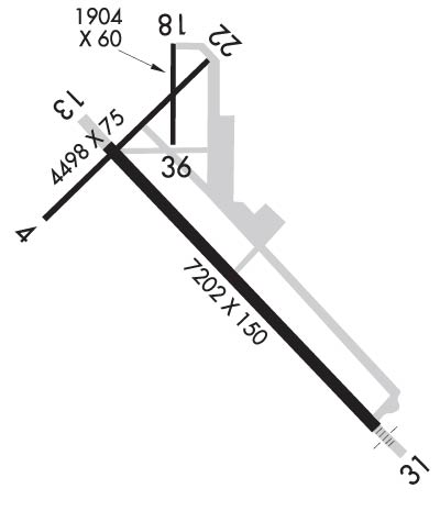 Airport Diagram might not be current. | |
| Facility Name: | MUSKOGEE-DAVIS RGNL |
| City Name: | MUSKOGEE |
| County: | MUSKOGEE |
| State abbrev: | OK |
| State Name: | OKLAHOMA |
| Ownership: | PUBLICLY OWNED |
| Use: | OPEN TO THE PUBLIC |
| Owner's Name: | CITY OF MUSKOGEE |
| Address: | MUNICIPAL BLDG, P.O. BOX 1927 |
| MUSKOGEE, OK 74402 | |
| Owner's Phone: | (918) 684-6201 |
| Manager's Name: | TYLER EVANS |
| Address: | 1201 SABRE ST |
| MUSKOGEE, OK 74403 | |
| Phone: | 918-684-6234; AFTER HRS FUEL CALL 918-869-8410. |
| FAA Region: | SOUTHWEST |
| FAA Field Office: | AOK |
| Date | Sunrise | Sunset |
|---|---|---|
| 06/08/26 Monday | 6:05 | 20:36 |
| 06/09/26 Tuesday | 6:05 | 20:36 |
| 06/10/26 Wednesday | 6:05 | 20:37 |
| 06/11/26 Thursday | 6:05 | 20:37 |
| 06/12/26 Friday | 6:05 | 20:38 |
| 06/13/26 Saturday | 6:05 | 20:38 |
| 06/14/26 Sunday | 6:05 | 20:38 |
| 06/15/26 Monday | 6:05 | 20:39 |
| 06/16/26 Tuesday | 6:05 | 20:39 |
| 06/17/26 Wednesday | 6:05 | 20:39 |
| 06/18/26 Thursday | 6:05 | 20:40 |
| 06/19/26 Friday | 6:06 | 20:40 |
| 06/20/26 Saturday | 6:06 | 20:40 |
| 06/21/26 Sunday | 6:06 | 20:40 |
| Airport Attendance Schedule | MON-SAT 0800-1700 |
| Airport Status | OPERATIONAL (This Status can change at any time - please check NOTAMS) |
| Airport Lighting Schedule | ACTVT MALS RWY 31; REIL RWY 13; MIRL RWY 13/31 - CTAF. PAPI RWY 13/31 ON CONSLY. |
| Airport Storage Available | Tie Downs, Hanger |
| Extra Services Available | Flight Instruction, Aircraft Rental, Aircraft Sales |
| Wind Indicator | YES - (lighted) |
| Control Tower | NO |
| CTAF Frequency | 122.800 |
| Unicom Frequency | 122.800 |
| Rotating Beacon Color | WG |
| Segmented Circle | YES |
| Landing Fee | NO |
| Airport Inspected | STATE - performed by STATE AERONAUTICAL PERSONNEL |
| Inspection Date | 05/09/2024 |
| Type of Fuel Available | Grade 100LL, JET A; -10100LL AVBL H24 SELF SVC. |
| Airframe Repair Service | MINOR |
| Power Plant Repair Service | MINOR |
| Latitude | N3539.5 |
| Longitude | W09521.7 (ESTIMATED) |
| Arpt Elevation | 611ft (SURVEYED) |
| Magnetic Variation | 06E |
| 6 miles S | of MUSKOGEE |
| Traffic Pattern Altitude | |
| Sectional Chart | DALLAS-FT WORTH |
| Operations (Reported) | Yearly | Avg. Daily |
|---|---|---|
| General Aviation Transient | 0 | 0 |
| General Aviation Local | 0 | 0 |
| Air Taxi | 0 | 0 |
| Commerical | 0 | 0 |
| Commuter | 0 | 0 |
| Military | 0 | 0 |
| Aircraft based on Field | |
|---|---|
| General Aviation Singles | 0 |
| General Aviation Multi | 0 |
| Jet Aircraft | 0 |
| General Aviation Helicopters | 0 |
| Military Aircraft | 0 |
| Gliders | 0 |
| Ultralights | 0 |
| FSS on field | NO |
| FSS tie-in | MC ALESTER |
| FSS Phone | 1-800-WX-BRIEF |
| Who issues Notams | MKO |
| Notam D service at airport | YES |
| ARTCC Name | FORT WORTH |
| Airport Certification | |
| Aircraft Rescue & Firefighting Index | None |
| Airport of Entry | No |
| Custom Landing Rights | No |
| Joint Civil/Military | No |
| Military Landing rights | YES |
| NATIONAL PLAN OF INTEGRATED AIRPORT SYSTEMS (NPIAS) |
| GRANT AGREEMENTS UNDER FAAP/ADAP/AIP |
| SURPLUS PROPERTY AGREEMENT UNDER PUBLIC LAW 289 |
| SURPLUS PROPERTY AGREEMENT UNDER REGULATION 16-WAA |
| ASSURANCES PURSUANT TO TITLE VI, CIVIL RIGHTS ACT OF 1964 |
| AGREEMENT UNDER DLAND OR DCLA HAS EXPIRED. |
| TWY B CLSD TO ACFT OVER 25,000 LBS. |
| OCNL COYOTES ON & INVOF RWY. |
| AIRPORT USED FOR OKLAHOMA NATIONAL GUARD ATC TRAINING EVENTS - IRREGULAR SCHEDULE. CONTACT ATCT ON 118.95 WHEN OPERATIONAL. |
| FOR CD IF UNA TO CTC ON FSS FREQ, CTC FORT WORTH ARTCC AT 817-858-7584. |
Airport Communications & Frequencies:
| |||||||||
| Runway: 04 | Runway: 22 | ||
| Mag heading: | 39° | Mag heading: | 219° |
| Rwy Slope: | -.32% Down | Rwy Slope: | .32% Up |
| Approach: | Approach: | ||
| Pattern: | Left Traffic | Pattern: | Left Traffic |
| Markings: | NONPRECISION INSTRUMENT | Markings: | NONPRECISION INSTRUMENT |
| Marking Condition: | GOOD | Marking Condition: | GOOD |
| Arresting Dev: | Arresting Dev: | ||
| Lat & Long: | N3539.4 W09522.3 | Lat. & Long.: | N3540.0 W09521.6 |
| Elev: | 610.7 ft. MSL | Elev: | 596.3 ft. MSL |
| TCH: | TCH: | ||
| Visual Glide Path: | Visual Glide Path: | ||
| Displaced Threshold: | No | Displaced Threshold: | No |
| Touchdown Zone: | YES | Touchdown Zone: | YES |
| Touchdown Elev.: | 611.5 feet | Touchdown Elev.: | 606.6 feet |
| Visual Glide Slope: | Visual Glide Slope: | ||
| RVR Equipment: | RVR Equipment: | ||
| RVV Equipment: | NO | RVV Equipment: | NO |
| Approach Lights: | Approach Lights: | ||
| REIL: | NO | REIL: | NO |
| Centerline Lights: | NO | Centerline Lights: | NO |
| Touchdown lights: | NO | Touchdown lights: | NO |
| Runway Category: | Runway with a Non-precision Approach having visibility minimums greater than 3/4 mile | Runway Category: | Runway with a Non-precision Approach having visibility minimums greater than 3/4 mile |
| Declared Distances: | Declared Distances: | ||
| Obstructions: | TREES | Obstructions: | |
| Marked: | NOT Marked/Lighted | Marked: | |
| Clearance slope: | 24:1 | Clearance slope: | 34:1 |
| Obstruction height: | 26 feet AGL | Obstruction height: | |
| Dist. from runway: | 831 feet | Dist. from runway: | |
| Centerline offset: | 207 right of centerline | Centerline offset: | |
| Comments: | Comments: |
| Runway: 13 | Runway: 31 | ||
| Mag heading: | 129° | Mag heading: | 309° |
| Rwy Slope: | -.36% Down | Rwy Slope: | .36% Up |
| Approach: | Approach: | ||
| Pattern: | Left Traffic | Pattern: | Left Traffic |
| Markings: | NONPRECISION INSTRUMENT | Markings: | NONPRECISION INSTRUMENT |
| Marking Condition: | GOOD | Marking Condition: | GOOD |
| Arresting Dev: | Arresting Dev: | ||
| Lat & Long: | N3539.7 W09522.0 | Lat. & Long.: | N3538.8 W09521.0 |
| Elev: | 606.8 ft. MSL | Elev: | 581.0 ft. MSL |
| TCH: | 50 ft. AGL | TCH: | 53 ft. AGL |
| Visual Glide Path: | 3.00 degrees | Visual Glide Path: | 3.00 degrees |
| Displaced Threshold: | No | Displaced Threshold: | No |
| Touchdown Zone: | YES | Touchdown Zone: | YES |
| Touchdown Elev.: | 606.8 feet | Touchdown Elev.: | 593.0 feet |
| Visual Glide Slope: | 4-Light PAPI on LEFT side of Runway | Visual Glide Slope: | 4-Light PAPI on LEFT side of Runway |
| RVR Equipment: | RVR Equipment: | ||
| RVV Equipment: | NO | RVV Equipment: | NO |
| Approach Lights: | Approach Lights: | MALS - 1,400 foot medium intensity approach lighting system | |
| REIL: | YES | REIL: | NO |
| Centerline Lights: | NO | Centerline Lights: | NO |
| Touchdown lights: | NO | Touchdown lights: | NO |
| Runway Category: | D | Runway Category: | D |
| Declared Distances: | Declared Distances: |
| Runway: 18 | Runway: 36 | ||
| Mag heading: | 174° | Mag heading: | 354° |
| Rwy Slope: | -.04% Down | Rwy Slope: | .04% Up |
| Approach: | Approach: | ||
| Pattern: | Left Traffic | Pattern: | Left Traffic |
| Markings: | BASIC | Markings: | BASIC |
| Marking Condition: | FAIR | Marking Condition: | FAIR |
| Arresting Dev: | Arresting Dev: | ||
| Lat & Long: | N3540.0 W09521.7 | Lat. & Long.: | N3539.6 W09521.7 |
| Elev: | 596.8 ft. MSL | Elev: | 596.1 ft. MSL |
| TCH: | TCH: | ||
| Visual Glide Path: | Visual Glide Path: | ||
| Displaced Threshold: | No | Displaced Threshold: | No |
| Touchdown Zone: | YES | Touchdown Zone: | YES |
| Touchdown Elev.: | 601.7 feet | Touchdown Elev.: | 601.7 feet |
| Visual Glide Slope: | Visual Glide Slope: | ||
| RVR Equipment: | RVR Equipment: | ||
| RVV Equipment: | NO | RVV Equipment: | NO |
| Approach Lights: | Approach Lights: | ||
| REIL: | NO | REIL: | NO |
| Centerline Lights: | NO | Centerline Lights: | NO |
| Touchdown lights: | NO | Touchdown lights: | NO |
| Runway Category: | Runway with a Visual Approach | Runway Category: | Runway with a Visual Approach |
| Declared Distances: | Declared Distances: |
Thanks for using FltPlan.com
all rights reserved © 1999-2026 by Flight Plan LLC
