| MUSKEGON COUNTY MUSKEGON MI |
| |
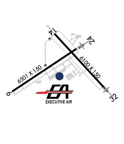
| Lat: N 4310.1 Long: W 08614.1 Elev: 629 Var: +04 Longest Runway: 6501 | ||
| Dept. ATIS: 124.3 Arr. ATIS: 124.3 Ground: 121.6 Tower: 126.25 | ||
| |||||||||||||||||||||||
| |||||||||||||||||||||||
| |||||||||||||||||||||||
| Rwy | Rwy | |||||||
| 6501x150 | 6501' | 6501x150 | 6501' | 109.50 - 240° | ||||
| 6100x150 | 6100' | 6100x150 | 6100' | 109.90 - 321° | ||||
| Runway ID | Single Wheel | Double Wheel | Double Tandem Wheel | Dual Double Wheel |
| 06/24 | 120,000 | 250,000 | 497,000 | N/A |
| 14/32 | 120,000 | 230,000 | 430,000 | N/A |
| These numbers are Advisory and are not limits. The Airport Manager should have more accurate Weight Limits | ||||
 Airport Diagram might not be current. | |
| Facility Name: | MUSKEGON COUNTY |
| City Name: | MUSKEGON |
| County: | MUSKEGON |
| State abbrev: | MI |
| State Name: | MICHIGAN |
| Ownership: | PUBLICLY OWNED |
| Use: | OPEN TO THE PUBLIC |
| Owner's Name: | MUSKEGON COUNTY |
| Address: | 99 SINCLAIR DR |
| NORTON SHORES, MI 49441-5542 | |
| Owner's Phone: | 231-798-4596 |
| Manager's Name: | JOEL BURGESS |
| Address: | 99 SINCLAIR DR |
| NORTON SHORES, MI 49441-5542 | |
| Phone: | 231-798-4596 |
| FAA Region: | GREAT LAKES |
| FAA Field Office: | DET |
| Date | Sunrise | Sunset |
|---|---|---|
| 09/24/21 Friday | 7:34 | 19:39 |
| 09/25/21 Saturday | 7:35 | 19:37 |
| 09/26/21 Sunday | 7:36 | 19:35 |
| 09/27/21 Monday | 7:37 | 19:34 |
| 09/28/21 Tuesday | 7:39 | 19:32 |
| 09/29/21 Wednesday | 7:40 | 19:30 |
| 09/30/21 Thursday | 7:41 | 19:28 |
| 10/01/21 Friday | 7:42 | 19:27 |
| 10/02/21 Saturday | 7:43 | 19:25 |
| 10/03/21 Sunday | 7:44 | 19:23 |
| 10/04/21 Monday | 7:45 | 19:21 |
| 10/05/21 Tuesday | 7:47 | 19:19 |
| 10/06/21 Wednesday | 7:48 | 19:18 |
| 10/07/21 Thursday | 7:49 | 19:16 |
| Airport Attendance Schedule | NOV-MAR MON-FRI 0600-2200, APR-OCT MON-FRI 0500-2100, APR-OCT SAT-SUN 0500-2000, NOV-MAR SAT-SUN 0600-2100; OTR HRS CALL 231-798-2126. |
| Airport Status | OPERATIONAL (This Status can change at any time - please check NOTAMS) |
| Airport Lighting Schedule | WHEN ATCT CLSD ACTVT MALSR RWY 24; REIL RWY 06; HIRL RWY 06/24 - CTAF. VASI RWY 06 & 24 OPR CONSLY. |
| Airport Storage Available | Tie Downs, Hanger |
| Extra Services Available | Air Freight, Air Ambulance, Cargo Handling, Charter, Flight Instruction, Aircraft Rental, Aircraft Sales |
| Wind Indicator | YES - (lighted) |
| Control Tower | YES |
| CTAF Frequency | 126.250 |
| Unicom Frequency | 122.950 |
| Rotating Beacon Color | CLEAR-GREEN (Light Land Airport) |
| Segmented Circle | NO |
| Landing Fee | YES |
| Airport Inspected | FEDERAL - performed by FAA AIRPORTS FIELD PERSONNEL |
| Inspection Date | 11/04/2020 |
| Type of Fuel Available | Grade 100LL, JET A (freeze point -40C) |
| Airframe Repair Service | MAJOR |
| Power Plant Repair Service | MAJOR |
| Latitude | N4310.1 |
| Longitude | W08614.1 (ESTIMATED) |
| Arpt Elevation | 628ft (SURVEYED) |
| Magnetic Variation | 04W |
| 4 miles S | of MUSKEGON |
| Traffic Pattern Altitude | |
| Sectional Chart | CHICAGO |
| Operations (Reported) | Yearly | Avg. Daily |
|---|---|---|
| General Aviation Transient | 12195 | 33 |
| General Aviation Local | 9890 | 27 |
| Air Taxi | 2106 | 6 |
| Commerical | 26 | 0 |
| Commuter | 0 | 0 |
| Military | 346 | 1 |
| Aircraft based on Field | |
|---|---|
| General Aviation Singles | 57 |
| General Aviation Multi | 16 |
| Jet Aircraft | 5 |
| General Aviation Helicopters | 2 |
| Military Aircraft | 1 |
| Gliders | 0 |
| Ultralights | 0 |
| FSS on field | NO |
| FSS tie-in | LANSING |
| FSS Phone | 1-800-WX-BRIEF |
| Who issues Notams | MKG |
| Notam D service at airport | YES |
| ARTCC Name | CHICAGO |
| Airport Certification | AIRPORT RECEIVING SCHEDULED AIR CARRIER SERVICE FROM CARRIERS CERTIFICATED BY THE CIVIL AERONAUTICS BOARD; ARFF INDEX B AVBL UPON REQ, CALL AMGR. |
| Aircraft Rescue & Firefighting Index | AIRPORT HAS A CERTIFICATE UNDER CFR PART 139 |
| Airport of Entry | No |
| Custom Landing Rights | No |
| Joint Civil/Military | No |
| Military Landing rights | YES |
| NATIONAL PLAN OF INTEGRATED AIRPORT SYSTEMS (NPIAS) |
| GRANT AGREEMENTS UNDER FAAP/ADAP/AIP |
| SURPLUS PROPERTY AGREEMENT UNDER REGULATION 16-WAA |
| ASSURANCES PURSUANT TO TITLE VI, CIVIL RIGHTS ACT OF 1964 |
| THIS AIRPORT HAS BEEN SURVEYED BY THE NATIONAL GEODETIC SURVEY. |
| DEER & BIRDS ON & INVOF ARPT. |
| 24 HR PPR FOR UNSKED ACR OPS WITH GTR THAN 30 PAX SEATS, CALL AMGR. |
| FOR CD WHEN ATCT CLSD CTC GREAT LAKES APCH AT 269-459-3344, WHEN APCH CLSD CTC CHICAGO ARTCC AT 630-906-8921. |
| RWY 14/3 2 CLSD DLY 2300-0600. |
Airport Communications & Frequencies:
| |||||||||||||||||||||||||||||||||
| Runway: 06 | Runway: 24 | ||
| Mag heading: | 60° | Mag heading: | 240° |
| Rwy Slope: | .08% Up | Rwy Slope: | -.08% Down |
| Approach: | Approach: | ILS/DME | |
| Pattern: | Left Traffic | Pattern: | Left Traffic |
| Markings: | PRECISION INSTRUMENT | Markings: | PRECISION INSTRUMENT |
| Marking Condition: | FAIR | Marking Condition: | FAIR |
| Arresting Dev: | Arresting Dev: | ||
| Lat & Long: | N4309.7 W08615.1 | Lat. & Long.: | N4310.3 W08613.8 |
| Elev: | 621.2 ft. MSL | Elev: | 626.5 ft. MSL |
| TCH: | 45 ft. AGL | TCH: | 58 ft. AGL |
| Visual Glide Path: | 3.00 degrees | Visual Glide Path: | 3.00 degrees |
| Displaced Threshold: | No | Displaced Threshold: | No |
| Touchdown Zone: | YES | Touchdown Zone: | YES |
| Touchdown Elev.: | 623.0 feet | Touchdown Elev.: | 627.0 feet |
| Visual Glide Slope: | 4-BOX VASI ON LEFT SIDE OF RUNWAY | Visual Glide Slope: | 4-BOX VASI ON LEFT SIDE OF RUNWAY |
| RVR Equipment: | RVR Equipment: | ||
| RVV Equipment: | NO | RVV Equipment: | NO |
| Approach Lights: | Approach Lights: | MALSR - 1,400 foot medium intensity approach lighting system with runway alignment indicator lights | |
| REIL: | YES | REIL: | NO |
| Centerline Lights: | NO | Centerline Lights: | NO |
| Touchdown lights: | NO | Touchdown lights: | NO |
| Runway Category: | Runway with a Non-precision Approach having visibility minimums greater than 3/4 mile | Runway Category: | Precision Instrument Runway |
| Declared Distances: | TORA:6501' TODA:6501' ASDA:6501' LDA:6501' | Declared Distances: | TORA:6501' TODA:6501' ASDA:6501' LDA:6501' |
| Obstructions: | TREES | Obstructions: | TREE |
| Marked: | NOT Marked/Lighted | Marked: | NOT Marked/Lighted |
| Clearance slope: | 29:1 | Clearance slope: | 34:1 |
| Obstruction height: | 85 feet AGL | Obstruction height: | 90 feet AGL |
| Dist. from runway: | 2681 feet | Dist. from runway: | 3312 feet |
| Centerline offset: | 192 right of centerline | Centerline offset: | 890 feet left of centerline |
| Comments: | Comments: |
| Runway: 14 | Runway: 32 | ||
| Mag heading: | 141° | Mag heading: | 321° |
| Rwy Slope: | .02% Up | Rwy Slope: | -.02% Down |
| Approach: | Approach: | ILS/DME | |
| Pattern: | Left Traffic | Pattern: | Left Traffic |
| Markings: | PRECISION INSTRUMENT | Markings: | PRECISION INSTRUMENT |
| Marking Condition: | GOOD | Marking Condition: | GOOD |
| Arresting Dev: | Arresting Dev: | ||
| Lat & Long: | N4310.5 W08614.3 | Lat. & Long.: | N4309.8 W08613.3 |
| Elev: | 627.4 ft. MSL | Elev: | 628.5 ft. MSL |
| TCH: | 45 ft. AGL | TCH: | |
| Visual Glide Path: | 3.00 degrees | Visual Glide Path: | |
| Displaced Threshold: | No | Displaced Threshold: | No |
| Touchdown Zone: | YES | Touchdown Zone: | YES |
| Touchdown Elev.: | 627.4 feet | Touchdown Elev.: | 628.5 feet |
| Visual Glide Slope: | 4-Light PAPI on LEFT side of Runway | Visual Glide Slope: | |
| RVR Equipment: | ROLLOUT | RVR Equipment: | TOUCHDOWN |
| RVV Equipment: | NO | RVV Equipment: | NO |
| Approach Lights: | Approach Lights: | MALSR - 1,400 foot medium intensity approach lighting system with runway alignment indicator lights | |
| REIL: | YES | REIL: | NO |
| Centerline Lights: | NO | Centerline Lights: | NO |
| Touchdown lights: | NO | Touchdown lights: | NO |
| Runway Category: | D | Runway Category: | Precision Instrument Runway |
| Declared Distances: | TORA:6100' TODA:6100' ASDA:6100' LDA:6100' | Declared Distances: | TORA:6100' TODA:6100' ASDA:6100' LDA:6100' |
Thanks for using FltPlan.com
all rights reserved © 1999-2021 by Flight Plan LLC