
| MIAMI INTL MIAMI FL |
| |
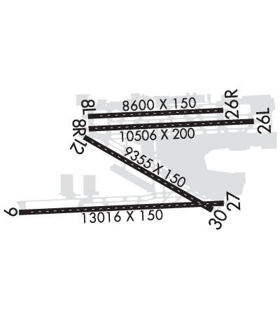
| Lat: N 2547.7 Long: W 08017.4 Elev: 9 Var: +05 Longest Runway: 13016 | ||
| Clr Del: 135.35 Dept. ATIS: 133.67 Arr. ATIS: 119.15 Ground: 121.8/127.5 Tower: 118.3/123.9 | ||
| ||||||||||||||||||||||||||||||||||||||||||||
| ||||||||||||||||||||||||||||||||||||||||||||
| ||||||||||||||||||||||||||||||||||||||||||||
| ||||||||||||||||||||||||||||||||||||||||||||
| Rwy | Rwy | |||||||
| 8600x150 | 8600' | 109.30 - 092° | 8600x150 | 8600' | 109.30 - 272° | |||
| 10506x200 | 10506' | 110.30 - 092° | 10506x200 | 10506' | 109.10 - 272° | |||
| 13016x150 | 11658' | 110.90 - 092° | 13016x150 | 12755' | 109.50 - 272° | |||
| 9360x150 | 9360' | 108.90 - 124° | 9360x150 | 8415' | 111.70 - 304° | |||
| Runway ID | Single Wheel | Double Wheel | Double Tandem Wheel | Dual Double Wheel |
| 08L/26R | 120,000 | 250,000 | 550,000 | 1,120,000 |
| 08R/26L | 120,000 | 250,000 | 550,000 | 1,120,000 |
| 09/27 | 120,000 | 250,000 | 550,000 | 1,120,000 |
| 12/30 | 120,000 | 250,000 | 550,000 | 1,120,000 |
| These numbers are Advisory and are not limits. The Airport Manager should have more accurate Weight Limits | ||||
 Airport Diagram might not be current. | |
| Facility Name: | MIAMI INTL |
| City Name: | MIAMI |
| County: | DADE |
| State abbrev: | FL |
| State Name: | FLORIDA |
| Ownership: | PUBLICLY OWNED |
| Use: | OPEN TO THE PUBLIC |
| Owner's Name: | DADE COUNTY AVIATON DEPT |
| Address: | PO BOX 025504 |
| MIAMI, FL 33102-5504 | |
| Owner's Phone: | 305-876-7077 |
| Manager's Name: | RALPH CUTIE; JIM MURPHY, AIRPORT SUPERVISOR 305-876-7516. |
| Address: | MIAMI-DADE AVIATION DEPARTMENT, P.O. BOX 025504 |
| MIAMI, FL 33102-5504 | |
| Phone: | 305-876-7038 |
| FAA Region: | SOUTHERN |
| FAA Field Office: | ORL |

| Date | Sunrise | Sunset |
|---|---|---|
| 04/15/24 Monday | 6:58 | 19:45 |
| 04/16/24 Tuesday | 6:57 | 19:45 |
| 04/17/24 Wednesday | 6:56 | 19:46 |
| 04/18/24 Thursday | 6:55 | 19:46 |
| 04/19/24 Friday | 6:54 | 19:47 |
| 04/20/24 Saturday | 6:53 | 19:47 |
| 04/21/24 Sunday | 6:52 | 19:48 |
| 04/22/24 Monday | 6:51 | 19:48 |
| 04/23/24 Tuesday | 6:50 | 19:49 |
| 04/24/24 Wednesday | 6:49 | 19:49 |
| 04/25/24 Thursday | 6:49 | 19:50 |
| 04/26/24 Friday | 6:48 | 19:50 |
| 04/27/24 Saturday | 6:47 | 19:51 |
| 04/28/24 Sunday | 6:46 | 19:51 |
| Airport Attendance Schedule | CONTINUOUS |
| Airport Status | OPERATIONAL (This Status can change at any time - please check NOTAMS) |
| Airport Lighting Schedule | |
| Airport Storage Available | Tie Downs, Hanger |
| Extra Services Available | Air Freight, Crop Dusting, Cargo Handling, Charter |
| Wind Indicator | YES - (lighted) |
| Control Tower | YES |
| CTAF Frequency | |
| Unicom Frequency | 123.000 |
| Rotating Beacon Color | WG |
| Segmented Circle | NO |
| Landing Fee | YES |
| Airport Inspected | FEDERAL - performed by FAA AIRPORTS FIELD PERSONNEL |
| Inspection Date | 04/14/2023 |
| Type of Fuel Available | Grade 100, JET A (freeze point -40C) |
| Airframe Repair Service | MAJOR |
| Power Plant Repair Service | MAJOR |
| Latitude | N2547.7 |
| Longitude | W08017.4 (ESTIMATED) |
| Arpt Elevation | 9ft (SURVEYED) |
| Magnetic Variation | 05W |
| 8 miles NW | of MIAMI |
| Traffic Pattern Altitude | |
| Sectional Chart | MIAMI |
| Operations (Reported) | Yearly | Avg. Daily |
|---|---|---|
| General Aviation Transient | 15357 | 42 |
| General Aviation Local | 0 | 0 |
| Air Taxi | 26378 | 72 |
| Commerical | 415774 | 1139 |
| Commuter | 0 | 0 |
| Military | 507 | 1 |
| Aircraft based on Field | |
|---|---|
| General Aviation Singles | 0 |
| General Aviation Multi | 13 |
| Jet Aircraft | 15 |
| General Aviation Helicopters | 0 |
| Military Aircraft | 0 |
| Gliders | 0 |
| Ultralights | 0 |
| FSS on field | NO |
| FSS tie-in | MIAMI |
| FSS Phone | 1-800-WX-BRIEF |
| Who issues Notams | MIA |
| Notam D service at airport | YES |
| ARTCC Name | MIAMI |
| Airport Certification | AIRPORT RECEIVING SCHEDULED AIR CARRIER SERVICE FROM CARRIERS CERTIFICATED BY THE CIVIL AERONAUTICS BOARD |
| Aircraft Rescue & Firefighting Index | AIRPORT HAS A CERTIFICATE UNDER CFR PART 139 |
| Airport of Entry | YES |
| Custom Landing Rights | No |
| Joint Civil/Military | No |
| Military Landing rights | YES |
| NATIONAL PLAN OF INTEGRATED AIRPORT SYSTEMS (NPIAS) |
| GRANT AGREEMENTS UNDER FAAP/ADAP/AIP |
| SURPLUS PROPERTY AGREEMENT UNDER PUBLIC LAW 289 |
| ASSURANCES PURSUANT TO TITLE VI, CIVIL RIGHTS ACT OF 1964 |
| CLSD NON ENG ACFT. |
| PPR 3 HRS PRIOR TO ALL ARRIVALS ON THE GENERAL AVIATION CENTER (GAC) RAMP 305-876-7550 CTC RAMP CONTROL UPON ARRIVAL ON FREQUENCY 131.600. ACFT WITH WINGSPAN GREATER THAN 78 FT ARE PROHIBITED FROM ENTERING THE GAC RAMP. |
| ALL MEDICAL EMERGENCIES ARRIVALS, WITH THE EXCEPTION OF AIR AMBULANCE FLIGHTS, MUST SECURE DOORS UNTIL ARFF IS ON SCENE. |
| ASDE-X IN USE. OPERATE TRANSPONDERS WITH ALTITUDE REPORTING MODE AND ADS-B (IF EQUIPPED) ENABLED ON ALL AIRPORT SURFACES. |
| PPR FOR INBOUND MILITARY FLIGHTS 100 NM ON FREQ 130.5. |
| ALL DIVERSION CTC FREQ 130.5 UPON ARR. |
| AIRPORT MANAGER: 305-876-7038. |
| NO INT DEP AUTH WO PPR FM AMGR. |
| AIRPORT OPS 305-876-7550. |
| US CBP AND EAPIS AVBL. |
| RWY 12-30 CLSD 0300-1200Z++ WHEN RWY 08R-26L AND RWY 09-27 ARE IN USE. |
| RWY 08L-26R CLSD 0300-1200Z++ WHEN RWY 08R-26L AND RWY 09-27 ARE IN USE. |
| CLOSE-IN NOISE ABATEMENT DEP PROFILE TO BE USED BY A319/320/321, A330-200/300, B727-200, B737-800/900, B767-200/300/400/700, B747-800, B777-300/77L/77W, AND MD-11. DSNT NOISE ABATEMENT DEP PROFILE TO BE USED BY ALL OTHER TURBOJET ACFT. |
| ACFT WITH A WINGSPAN GTR THAN 171 FT ARE PROHIBITED FM TXG ON TWY P EAST OF TWY U. |
| ALL TURBOJET ACFT USE DSNT NOISE ABATEMENT DEP PROFILE FM ALL RWYS EXC A320, B727, B737/800, B767/400, AND DC9. WHICH SHOULD USE CLOSE/IN NOISE ABATEMENT PROFILE. |
| BIRDS ON & INVOF ARPT. |
| RWY 08L/ 26RRWY 08L/26R CLSD 0300-1200++ WHEN RWY 08R/26L & RWY 09/27 ARE IN USE. |
| RWY 12/3 0 RWY 12/30 CLSD 0300-1200++ WHEN RWY 08R/26L & RWY 09/27 ARE IN USE. |
| RWY 08L/ 26RPCR VALUE: 711/F/A/X/T |
| RWY 08R/ 26LPCR VALUE: 851/F/A/X/T |
| RWY 09/2 7 PCR VALUE: 851/F/A/X/T |
| RWY 12/3 0 PCR VALUE: 780/F/A/X/T |
Airport Communications & Frequencies:
| ||||||||||||||||||||||||||||||||||||||||||||||||||||||||||||
| Runway: 08L | Runway: 26R | ||
| Mag heading: | 92° | Mag heading: | 272° |
| Rwy Slope: | .00% Down | Rwy Slope: | .00% Up |
| Approach: | LOC/DME | Approach: | LOC/DME |
| Pattern: | Left Traffic | Pattern: | Left Traffic |
| Markings: | NONPRECISION INSTRUMENT | Markings: | NONPRECISION INSTRUMENT |
| Marking Condition: | GOOD | Marking Condition: | GOOD |
| Arresting Dev: | Arresting Dev: | ||
| Lat & Long: | N2548.2 W08018.1 | Lat. & Long.: | N2548.2 W08016.5 |
| Elev: | 8.9 ft. MSL | Elev: | 8.8 ft. MSL |
| TCH: | 60 ft. AGL | TCH: | 60 ft. AGL |
| Visual Glide Path: | 3.00 degrees | Visual Glide Path: | 3.00 degrees |
| Displaced Threshold: | No | Displaced Threshold: | No |
| Touchdown Zone: | YES | Touchdown Zone: | YES |
| Touchdown Elev.: | 9.1 feet | Touchdown Elev.: | 9.0 feet |
| Visual Glide Slope: | 4-Light PAPI on LEFT side of Runway | Visual Glide Slope: | 4-Light PAPI on LEFT side of Runway |
| RVR Equipment: | RVR Equipment: | ||
| RVV Equipment: | NO | RVV Equipment: | NO |
| Approach Lights: | Approach Lights: | ||
| REIL: | YES | REIL: | YES |
| Centerline Lights: | YES | Centerline Lights: | YES |
| Touchdown lights: | NO | Touchdown lights: | NO |
| Runway Category: | D | Runway Category: | D |
| Declared Distances: | TORA:8600' TODA:8600' ASDA:8600' LDA:8600' | Declared Distances: | TORA:8600' TODA:8600' ASDA:8600' LDA:8600' |
| Runway: 08R | Runway: 26L | ||
| Mag heading: | 92° | Mag heading: | 272° |
| Rwy Slope: | .00% Up | Rwy Slope: | .00% Down |
| Approach: | ILS/DME | Approach: | ILS/DME |
| Pattern: | Left Traffic | Pattern: | Right Traffic |
| Markings: | PRECISION INSTRUMENT | Markings: | PRECISION INSTRUMENT |
| Marking Condition: | GOOD | Marking Condition: | GOOD |
| Arresting Dev: | Arresting Dev: | ||
| Lat & Long: | N2548.0 W08018.1 | Lat. & Long.: | N2548.1 W08016.2 |
| Elev: | 8.5 ft. MSL | Elev: | 8.9 ft. MSL |
| TCH: | 77 ft. AGL | TCH: | 73 ft. AGL |
| Visual Glide Path: | 3.00 degrees | Visual Glide Path: | 3.00 degrees |
| Displaced Threshold: | No | Displaced Threshold: | No |
| Touchdown Zone: | YES | Touchdown Zone: | YES |
| Touchdown Elev.: | 9.1 feet | Touchdown Elev.: | 9.0 feet |
| Visual Glide Slope: | 4-Light PAPI on LEFT side of Runway | Visual Glide Slope: | 4-Light PAPI on LEFT side of Runway |
| RVR Equipment: | TOUCHDOWN-ROLLOUT | RVR Equipment: | TOUCHDOWN-ROLLOUT |
| RVV Equipment: | NO | RVV Equipment: | NO |
| Approach Lights: | MALSR - 1,400 foot medium intensity approach lighting system with runway alignment indicator lights | Approach Lights: | MALSF - 1,400 foot medium intensity approach lighting system with sequenced flashers |
| REIL: | NO | REIL: | NO |
| Centerline Lights: | YES | Centerline Lights: | YES |
| Touchdown lights: | YES | Touchdown lights: | NO |
| Runway Category: | Precision Instrument Runway | Runway Category: | Precision Instrument Runway |
| Declared Distances: | TORA:10506' TODA:10506' ASDA:10506' LDA:10506' | Declared Distances: | TORA:10506' TODA:10506' ASDA:10220' LDA:10220' |
| Runway: 09 | Runway: 27 | ||
| Mag heading: | 92° | Mag heading: | 272° |
| Rwy Slope: | .01% Up | Rwy Slope: | -.01% Down |
| Approach: | ILS/DME | Approach: | ILS |
| Pattern: | Right Traffic | Pattern: | Left Traffic |
| Markings: | PRECISION INSTRUMENT | Markings: | PRECISION INSTRUMENT |
| Marking Condition: | GOOD | Marking Condition: | GOOD |
| Arresting Dev: | Arresting Dev: | ||
| Lat & Long: | N2547.2 W08018.9 | Lat. & Long.: | N2547.3 W08016.5 |
| Elev: | 8.1 ft. MSL | Elev: | 9.0 ft. MSL |
| TCH: | 72 ft. AGL | TCH: | 71 ft. AGL |
| Visual Glide Path: | 3.00 degrees | Visual Glide Path: | 3.00 degrees |
| Displaced Threshold: | 1358 feet | Displaced Threshold: | 261 feet |
| Touchdown Zone: | YES | Touchdown Zone: | YES |
| Touchdown Elev.: | 8.2 feet | Touchdown Elev.: | 9.1 feet |
| Visual Glide Slope: | 4-Light PAPI on LEFT side of Runway | Visual Glide Slope: | 4-Light PAPI on LEFT side of Runway |
| RVR Equipment: | TOUCHDOWN-MIDFIELD-ROLLOUT | RVR Equipment: | TOUCHDOWN-MIDFIELD-ROLLOUT |
| RVV Equipment: | NO | RVV Equipment: | NO |
| Approach Lights: | MALSR - 1,400 foot medium intensity approach lighting system with runway alignment indicator lights | Approach Lights: | MALSR - 1,400 foot medium intensity approach lighting system with runway alignment indicator lights |
| REIL: | NO | REIL: | NO |
| Centerline Lights: | YES | Centerline Lights: | YES |
| Touchdown lights: | NO | Touchdown lights: | NO |
| Runway Category: | Precision Instrument Runway | Runway Category: | Precision Instrument Runway |
| Declared Distances: | TORA:13016' TODA:13016' ASDA:12755' LDA:11397' | Declared Distances: | TORA:13016' TODA:13016' ASDA:13016' LDA:12755' |
| Obstructions: | RR | Obstructions: | |
| Marked: | NOT Marked/Lighted | Marked: | |
| Clearance slope: | 23:1; APCH RATIO 50:1 TO DSPLCD THR. | Clearance slope: | 50:1 |
| Obstruction height: | 23 feet AGL | Obstruction height: | |
| Dist. from runway: | 750 feet | Dist. from runway: | |
| Centerline offset: | 580 right of centerline | Centerline offset: | |
| Comments: | Comments: |
| Runway: 12 | Runway: 30 | ||
| Mag heading: | 124° | Mag heading: | 304° |
| Rwy Slope: | .00% Down | Rwy Slope: | .00% Up |
| Approach: | ILS/DME | Approach: | ILS/DME |
| Pattern: | Left Traffic | Pattern: | Left Traffic |
| Markings: | PRECISION INSTRUMENT | Markings: | PRECISION INSTRUMENT |
| Marking Condition: | GOOD | Marking Condition: | GOOD |
| Arresting Dev: | Arresting Dev: | ||
| Lat & Long: | N2548.0 W08018.1 | Lat. & Long.: | N2547.2 W08016.7 |
| Elev: | 9.1 ft. MSL | Elev: | 8.7 ft. MSL |
| TCH: | 72 ft. AGL | TCH: | 71 ft. AGL |
| Visual Glide Path: | 3.00 degrees | Visual Glide Path: | 3.00 degrees |
| Displaced Threshold: | No | Displaced Threshold: | 945 feet |
| Touchdown Zone: | YES | Touchdown Zone: | YES |
| Touchdown Elev.: | 9.2 feet | Touchdown Elev.: | 9.3 feet |
| Visual Glide Slope: | 4-Light PAPI on RIGHT side of Runway | Visual Glide Slope: | 4-Light PAPI on LEFT side of Runway |
| RVR Equipment: | TOUCHDOWN-ROLLOUT | RVR Equipment: | TOUCHDOWN-ROLLOUT |
| RVV Equipment: | NO | RVV Equipment: | NO |
| Approach Lights: | MALSR - 1,400 foot medium intensity approach lighting system with runway alignment indicator lights | Approach Lights: | MALS - 1,400 foot medium intensity approach lighting system |
| REIL: | NO | REIL: | NO |
| Centerline Lights: | YES | Centerline Lights: | YES |
| Touchdown lights: | NO | Touchdown lights: | NO |
| Runway Category: | Precision Instrument Runway | Runway Category: | Precision Instrument Runway |
| Declared Distances: | TORA:9355' TODA:9355' ASDA:8579' LDA:8579' | Declared Distances: | TORA:9355' TODA:9355' ASDA:8853' LDA:7913' |
| Obstructions: | TOWER | Obstructions: | TREE |
| Marked: | NOT Marked/Lighted | Marked: | NOT Marked/Lighted |
| Clearance slope: | 37:1 | Clearance slope: | 26:1; APCH RATIO 48:1 TO DSPLCD THR. |
| Obstruction height: | 40 feet AGL | Obstruction height: | 52 feet AGL |
| Dist. from runway: | 1700 feet | Dist. from runway: | 1600 feet |
| Centerline offset: | 200 left of centerline | Centerline offset: | 300 feet left of centerline |
| Comments: | Comments: | +20' RR 200' FM RY END; 450'L. |
Thanks for using FltPlan.com
all rights reserved © 1999-2024 by Flight Plan LLC