
| MOJAVE MOJAVE CA |
| |
| Lat: N 3503.5 Long: W 11809.0 Elev: 2801 Var: -14 Longest Runway: 12503 | ||
| AWOS: 132.22 Ground: 123.9 Tower: 127.6 | ||
| ||||||||||||||||||||||||||||||||||||||||||||
| ||||||||||||||||||||||||||||||||||||||||||||
| ||||||||||||||||||||||||||||||||||||||||||||
| Rwy | Rwy | |||||||
| 4747x60 | 4747' | 4747x60 | 4747' | |||||
| 7049x100 | 7049' | 7049x100 | 7049' | |||||
| 12503x200 | 11903' | 12503x200 | 11603' | |||||
| Runway ID | Single Wheel | Double Wheel | Double Tandem Wheel | Dual Double Wheel |
| 04/22 | 40,000 | 60,000 | 60,000 | N/A |
| 08/26 | 40,000 | 60,000 | 88,000 | N/A |
| 12/30 | 120,000 | 150,000 | 450,000 | N/A |
| These numbers are Advisory and are not limits. The Airport Manager should have more accurate Weight Limits | ||||
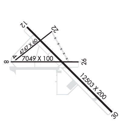 Airport Diagram might not be current. | |
| Facility Name: | MOJAVE AIR AND SPACE PORT |
| City Name: | MOJAVE |
| County: | KERN |
| State abbrev: | CA |
| State Name: | CALIFORNIA |
| Ownership: | PUBLICLY OWNED |
| Use: | OPEN TO THE PUBLIC |
| Owner's Name: | MOJAVE AIR AND SPACE PORT |
| Address: | 1434 FLIGHTLINE |
| MOJAVE, CA 93501 | |
| Owner's Phone: | 661-824-2433 |
| Manager's Name: | TODD LINDNER |
| Address: | 1434 FLIGHTLINE |
| MOJAVE, CA 93501 | |
| Phone: | 661-824-2433 |
| FAA Region: | WESTERN-PACIFIC |
| FAA Field Office: | LAX |
| Date | Sunrise | Sunset |
|---|---|---|
| 09/24/21 Friday | 6:42 | 18:47 |
| 09/25/21 Saturday | 6:43 | 18:45 |
| 09/26/21 Sunday | 6:43 | 18:44 |
| 09/27/21 Monday | 6:44 | 18:42 |
| 09/28/21 Tuesday | 6:45 | 18:41 |
| 09/29/21 Wednesday | 6:46 | 18:40 |
| 09/30/21 Thursday | 6:46 | 18:38 |
| 10/01/21 Friday | 6:47 | 18:37 |
| 10/02/21 Saturday | 6:48 | 18:35 |
| 10/03/21 Sunday | 6:49 | 18:34 |
| 10/04/21 Monday | 6:50 | 18:33 |
| 10/05/21 Tuesday | 6:50 | 18:31 |
| 10/06/21 Wednesday | 6:51 | 18:30 |
| 10/07/21 Thursday | 6:52 | 18:28 |
| Airport Attendance Schedule | CONTINUOUS |
| Airport Status | OPERATIONAL (This Status can change at any time - please check NOTAMS) |
| Airport Lighting Schedule | ACTVT REIL RWYS 12 & 30; MIRL RWYS 08/26 & 04/22; HIRL RWY 12/30 - CTAF. |
| Airport Storage Available | Tie Downs |
| Extra Services Available | Avionics, Flight Instruction |
| Wind Indicator | YES - (lighted) |
| Control Tower | YES |
| CTAF Frequency | 127.600 |
| Unicom Frequency | |
| Rotating Beacon Color | CLEAR-GREEN (Light Land Airport) |
| Segmented Circle | YES |
| Landing Fee | NO |
| Airport Inspected | STATE - performed by STATE AERONAUTICAL PERSONNEL |
| Inspection Date | 04/29/2021 |
| Type of Fuel Available | Grade 100LL, JET A (freeze point -40C), JET A; -10FUEL AVBL 0700-1700, MON-SAT; OTR TIMES CTC SECURITY ON CTAF, FEE CHARGED. |
| Airframe Repair Service | MAJOR |
| Power Plant Repair Service | MAJOR |
| Latitude | N3503.5 |
| Longitude | W11809.0 (ESTIMATED) |
| Arpt Elevation | 2801ft (SURVEYED) |
| Magnetic Variation | 14E |
| 1 miles E | of MOJAVE |
| Traffic Pattern Altitude | CAT C/D & ALL TBJT ACFT TPA 4301 FT MSL (1500 FT AGL); CAT A/B ACFT TPA 3801 FT MSL (1000 FT AGL); HEL TPA 3301 FT MSL (500 FT AGL) AND USE SOUTH ENTRY AND DEP. |
| Sectional Chart | LOS ANGELES |
| Operations (Reported) | Yearly | Avg. Daily |
|---|---|---|
| General Aviation Transient | 9718 | 27 |
| General Aviation Local | 8426 | 23 |
| Air Taxi | 6 | 0 |
| Commerical | 33 | 0 |
| Commuter | 0 | 0 |
| Military | 3119 | 9 |
| Aircraft based on Field | |
|---|---|
| General Aviation Singles | 27 |
| General Aviation Multi | 4 |
| Jet Aircraft | 15 |
| General Aviation Helicopters | 9 |
| Military Aircraft | 12 |
| Gliders | 3 |
| Ultralights | 0 |
| FSS on field | NO |
| FSS tie-in | RIVERSIDE |
| FSS Phone | 1-800-WX-BRIEF |
| Who issues Notams | MHV |
| Notam D service at airport | YES |
| ARTCC Name | LOS ANGELES |
| Airport Certification | |
| Aircraft Rescue & Firefighting Index | None |
| Airport of Entry | No |
| Custom Landing Rights | No |
| Joint Civil/Military | No |
| Military Landing rights | YES |
| NATIONAL PLAN OF INTEGRATED AIRPORT SYSTEMS (NPIAS) |
| GRANT AGREEMENTS UNDER FAAP/ADAP/AIP |
| SURPLUS PROPERTY AGREEMENT UNDER PUBLIC LAW 289 |
| ASSURANCES PURSUANT TO TITLE VI, CIVIL RIGHTS ACT OF 1964 |
| AGREEMENT UNDER DLAND OR DCLA HAS EXPIRED. |
| BE ALERT TO HIGH SPEED ACTIVITY INVOF ARPT. |
| DUE TO RAPIDLY RISING TERRAIN AND WIND TURBINES W - NW OF ARPT, CAT C/D & ALL TURBOJET ACFT LDG RWY 8 MUST REMAIN AT OR ABOVE 4301 FT MSL UNTIL COMMENCING BASE LEG TURN AND AT OR ABOVE 3800 FT MSL UNTIL ESTABLISHED ON A 2.25 NM FINAL. |
| TWY F IS CLSD. |
| RWY 08/2 6 300 FT PAVED OVERRUN EAST END OF RY; 300 FT PAVED OVERRUN WEST END OF RY. |
Airport Communications & Frequencies:
| |||||||||||||||||||||
| Runway: 04 | Runway: 22 | ||
| Mag heading: | 38° | Mag heading: | 218° |
| Rwy Slope: | -.02% Down | Rwy Slope: | .02% Up |
| Approach: | Approach: | ||
| Pattern: | Left Traffic | Pattern: | Right Traffic |
| Markings: | NONPRECISION INSTRUMENT | Markings: | NONPRECISION INSTRUMENT |
| Marking Condition: | GOOD | Marking Condition: | GOOD |
| Arresting Dev: | Arresting Dev: | ||
| Lat & Long: | N3503.6 W11809.9 | Lat. & Long.: | N3504.1 W11809.1 |
| Elev: | 2779.9 ft. MSL | Elev: | 2779.1 ft. MSL |
| TCH: | 39 ft. AGL | TCH: | 40 ft. AGL |
| Visual Glide Path: | 4.00 degrees | Visual Glide Path: | 3.00 degrees |
| Displaced Threshold: | No | Displaced Threshold: | No |
| Touchdown Zone: | YES | Touchdown Zone: | YES |
| Touchdown Elev.: | 2780.0 feet | Touchdown Elev.: | 2780.2 feet |
| Visual Glide Slope: | 2-Light PAPI on LEFT side of Runway | Visual Glide Slope: | 2-Light PAPI on LEFT side of Runway |
| RVR Equipment: | RVR Equipment: | ||
| RVV Equipment: | NO | RVV Equipment: | NO |
| Approach Lights: | Approach Lights: | ||
| REIL: | NO | REIL: | NO |
| Centerline Lights: | NO | Centerline Lights: | NO |
| Touchdown lights: | NO | Touchdown lights: | NO |
| Runway Category: | Runway with a Non-precision Approach | Runway Category: | Runway with a Non-precision Approach |
| Declared Distances: | Declared Distances: | ||
| Obstructions: | POLE | Obstructions: | |
| Marked: | NOT Marked/Lighted | Marked: | |
| Clearance slope: | 45:1 | Clearance slope: | 50:1 |
| Obstruction height: | 44 feet AGL | Obstruction height: | |
| Dist. from runway: | 2200 feet | Dist. from runway: | |
| Centerline offset: | Centerline offset: | ||
| Comments: | Comments: |
| Runway: 08 | Runway: 26 | ||
| Mag heading: | 76° | Mag heading: | 256° |
| Rwy Slope: | -.65% Down | Rwy Slope: | .65% Up |
| Approach: | Approach: | ||
| Pattern: | Left Traffic | Pattern: | Right Traffic |
| Markings: | NONPRECISION INSTRUMENT | Markings: | NONPRECISION INSTRUMENT |
| Marking Condition: | GOOD | Marking Condition: | GOOD |
| Arresting Dev: | Arresting Dev: | ||
| Lat & Long: | N3503.6 W11810.0 | Lat. & Long.: | N3503.5 W11808.6 |
| Elev: | 2780.4 ft. MSL | Elev: | 2734.9 ft. MSL |
| TCH: | 55 ft. AGL | TCH: | 52 ft. AGL |
| Visual Glide Path: | 4.00 degrees | Visual Glide Path: | 3.00 degrees |
| Displaced Threshold: | No | Displaced Threshold: | No |
| Touchdown Zone: | YES | Touchdown Zone: | YES |
| Touchdown Elev.: | 2780.4 feet | Touchdown Elev.: | 2756.9 feet |
| Visual Glide Slope: | 2-Light PAPI on LEFT side of Runway | Visual Glide Slope: | 2-Light PAPI on LEFT side of Runway |
| RVR Equipment: | RVR Equipment: | ||
| RVV Equipment: | NO | RVV Equipment: | NO |
| Approach Lights: | Approach Lights: | ||
| REIL: | NO | REIL: | NO |
| Centerline Lights: | NO | Centerline Lights: | NO |
| Touchdown lights: | NO | Touchdown lights: | NO |
| Runway Category: | Runway with a Visual Approach | Runway Category: | Runway with a Visual Approach |
| Declared Distances: | Declared Distances: |
| Runway: 12 | Runway: 30 | ||
| Mag heading: | 121° | Mag heading: | 301° |
| Rwy Slope: | -.97% Down | Rwy Slope: | .97% Up |
| Approach: | Approach: | ||
| Pattern: | Left Traffic | Pattern: | Right Traffic |
| Markings: | NONPRECISION INSTRUMENT | Markings: | NONPRECISION INSTRUMENT |
| Marking Condition: | FAIR | Marking Condition: | FAIR |
| Arresting Dev: | Arresting Dev: | ||
| Lat & Long: | N3504.1 W11809.6 | Lat. & Long.: | N3502.7 W11807.9 |
| Elev: | 2801.3 ft. MSL | Elev: | 2680.2 ft. MSL |
| TCH: | 68 ft. AGL | TCH: | 62 ft. AGL |
| Visual Glide Path: | 3.00 degrees | Visual Glide Path: | 3.00 degrees |
| Displaced Threshold: | 600 feet | Displaced Threshold: | 900 feet |
| Touchdown Zone: | YES | Touchdown Zone: | YES |
| Touchdown Elev.: | 2794.8 feet | Touchdown Elev.: | 2712.3 feet |
| Visual Glide Slope: | 4-Light PAPI on LEFT side of Runway; PAPI UNUSBL BEYOND 2.5 NM. | Visual Glide Slope: | 4-Light PAPI on LEFT side of Runway |
| RVR Equipment: | RVR Equipment: | ||
| RVV Equipment: | NO | RVV Equipment: | NO |
| Approach Lights: | Approach Lights: | ||
| REIL: | YES | REIL: | YES |
| Centerline Lights: | NO | Centerline Lights: | NO |
| Touchdown lights: | NO | Touchdown lights: | NO |
| Runway Category: | Runway with a Visual Approach | Runway Category: | Runway with a Visual Approach |
| Declared Distances: | Declared Distances: | ||
| Obstructions: | OTHER; WIND TURBINE | Obstructions: | |
| Marked: | NOT Marked/Lighted | Marked: | |
| Clearance slope: | 37:1; APPROACH SLOPE 40:1 TO THE DSPLCD THR. | Clearance slope: | 50:1 |
| Obstruction height: | 375 feet AGL | Obstruction height: | |
| Dist. from runway: | 14400 feet | Dist. from runway: | |
| Centerline offset: | 250 left of centerline | Centerline offset: | |
| Comments: | Comments: |
Thanks for using FltPlan.com
all rights reserved © 1999-2021 by Flight Plan LLC
