
| MANCHESTER MANCHESTER NH |
| |
| Lat: N 4256.0 Long: W 07126.1 Elev: 266 Var: +15 Longest Runway: 9250 | ||
| Clr Del: 135.9 Dept. ATIS: 119.55 Arr. ATIS: 119.55 AWOS: 119.55 Ground: 121.9 Tower: 121.3 | ||
| ||||||||||||||||||||||||||||||||||||||||||||
| ||||||||||||||||||||||||||||||||||||||||||||
| ||||||||||||||||||||||||||||||||||||||||||||
| Rwy | Rwy | |||||||
| 7651x150 | 7209' | 109.95 - 057° | 7651x150 | 7651' | ||||
| 9250x150 | 8914' | 109.10 - 171° | 9250x150 | 8400' | 109.10 - 351° | |||
| Runway ID | Single Wheel | Double Wheel | Double Tandem Wheel | Dual Double Wheel |
| 06/24 | 200,000 | 300,000 | 350,000 | N/A |
| 17/35 | 200,000 | 300,000 | 350,000 | N/A |
| These numbers are Advisory and are not limits. The Airport Manager should have more accurate Weight Limits | ||||
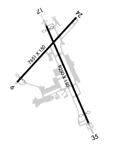 Airport Diagram might not be current. | |
| Facility Name: | MANCHESTER BOSTON RGNL |
| City Name: | MANCHESTER |
| County: | HILLSBOROUGH |
| State abbrev: | NH |
| State Name: | NEW HAMPSHIRE |
| Ownership: | PUBLICLY OWNED |
| Use: | OPEN TO THE PUBLIC |
| Owner's Name: | CITY OF MANCHESTER |
| Address: | CITY HALL |
| MANCHESTER, NH 03101 | |
| Owner's Phone: | 603-624-6539 |
| Manager's Name: | THOMAS J. MALAFRONTE |
| Address: | 1 AIRPORT RD SUITE 300 |
| MANCHESTER, NH 03103 | |
| Phone: | 603-624-6539 |
| FAA Region: | NEW ENGLAND |
| FAA Field Office: | NONE |
| Date | Sunrise | Sunset |
|---|---|---|
| 06/08/26 Monday | 5:07 | 20:23 |
| 06/09/26 Tuesday | 5:07 | 20:23 |
| 06/10/26 Wednesday | 5:07 | 20:24 |
| 06/11/26 Thursday | 5:06 | 20:24 |
| 06/12/26 Friday | 5:06 | 20:25 |
| 06/13/26 Saturday | 5:06 | 20:25 |
| 06/14/26 Sunday | 5:06 | 20:26 |
| 06/15/26 Monday | 5:06 | 20:26 |
| 06/16/26 Tuesday | 5:06 | 20:27 |
| 06/17/26 Wednesday | 5:06 | 20:27 |
| 06/18/26 Thursday | 5:06 | 20:27 |
| 06/19/26 Friday | 5:06 | 20:28 |
| 06/20/26 Saturday | 5:07 | 20:28 |
| 06/21/26 Sunday | 5:07 | 20:28 |
| Airport Attendance Schedule | CONTINUOUS |
| Airport Status | OPERATIONAL (This Status can change at any time - please check NOTAMS) |
| Airport Lighting Schedule | SS-SR |
| Airport Storage Available | Tie Downs, Hanger |
| Extra Services Available | Air Freight, Avionics, Charter, Flight Instruction, Aircraft Rental |
| Wind Indicator | YES - (lighted) |
| Control Tower | YES |
| CTAF Frequency | |
| Unicom Frequency | 122.950 |
| Rotating Beacon Color | WG |
| Segmented Circle | NO |
| Landing Fee | YES |
| Airport Inspected | FEDERAL - performed by FAA AIRPORTS FIELD PERSONNEL |
| Inspection Date | 09/11/2025 |
| Type of Fuel Available | Grade 100LL, JET A (freeze point -40C) |
| Airframe Repair Service | MAJOR |
| Power Plant Repair Service | MAJOR |
| Latitude | N4256.0 |
| Longitude | W07126.1 (ESTIMATED) |
| Arpt Elevation | 266ft (SURVEYED) |
| Magnetic Variation | 15W |
| 3 miles S | of MANCHESTER |
| Traffic Pattern Altitude | |
| Sectional Chart | NEW YORK |
| Operations (Reported) | Yearly | Avg. Daily |
|---|---|---|
| General Aviation Transient | 0 | 0 |
| General Aviation Local | 0 | 0 |
| Air Taxi | 0 | 0 |
| Commerical | 0 | 0 |
| Commuter | 0 | 0 |
| Military | 0 | 0 |
| Aircraft based on Field | |
|---|---|
| General Aviation Singles | 0 |
| General Aviation Multi | 0 |
| Jet Aircraft | 0 |
| General Aviation Helicopters | 0 |
| Military Aircraft | 0 |
| Gliders | 0 |
| Ultralights | 0 |
| FSS on field | NO |
| FSS tie-in | BANGOR |
| FSS Phone | 1-800-WX-BRIEF |
| Who issues Notams | MHT |
| Notam D service at airport | YES |
| ARTCC Name | BOSTON |
| Airport Certification | AIRPORT RECEIVING SCHEDULED AIR CARRIER SERVICE FROM CARRIERS CERTIFICATED BY THE CIVIL AERONAUTICS BOARD |
| Aircraft Rescue & Firefighting Index | AIRPORT HAS A CERTIFICATE UNDER CFR PART 139 |
| Airport of Entry | No |
| Custom Landing Rights | No; US CUSTOMS USER FEE ARPT. |
| Joint Civil/Military | No |
| Military Landing rights | YES |
| NATIONAL PLAN OF INTEGRATED AIRPORT SYSTEMS (NPIAS) |
| GRANT AGREEMENTS UNDER FAAP/ADAP/AIP |
| SURPLUS PROPERTY AGREEMENT UNDER PUBLIC LAW 289 |
| ASSURANCES PURSUANT TO TITLE VI, CIVIL RIGHTS ACT OF 1964 |
| AIR CARRIER ACFT ONLY PERMITTED TO OPR ON AIRLINE TERMINAL RAMP. |
| JET ACFT TAXIING WB ACRS RWY 17/35 AT TWY E MUST USE CTN & LOW SETTINGS DUE TO LGT ACFT PRKG ON E RAMP. |
| NO TAXIING BTWN PUSHED BACK ACFT & THE AIRLINE TERMINAL OR CARGO RAMPS. |
| AIR CARRIERS EXCLUDED FM OPERATING ON TWY L. |
| TWY A SAFETY AREA S OF TWY E TO TWY A2 IS 65 FT. |
| ACFT WITH WINGSPAN GREATER THAN 124 FT RSTRD FM TWY G AND TWY N. |
| AMMON RAMP RSTRD TO ACFT WITH WINGSPAN LESS THAN 118 FT. ACFT ARE REQ TO MNTN TAXILANE CNTRLN TO AVOID PARKED GA ACFT TIEDOWNS. ACFT WITH WINGSPAN 118 FT OR GTR REQ GND CREW ASSISTANCE FOR TAXI & PRKG. |
| NO TGLS PERMITTED DURG SNOW REMOVAL OPNS. |
| NOISE ABATEMENT PROCEDURES: TURBOJET ACFT SHOULD EXPECT A RIGHT TURN WHEN DEPARTING RY 17. |
| ACFT NOT PERMITTED TO TAXI BETWEEN AIRLINE TERMINAL BLDG & ACFT THAT HAVE PUSHED BACK OR ARE TAXIING ON TWY G OR N. |
| RWY 06/2 4 PCR VALUE: 700/F/C/X/T |
| RWY 17/3 5 PCR VALUE: 700/F/C/X/T |
Airport Communications & Frequencies:
| |||||||||||||||||||||||||||||||||||
| Runway: 06 | Runway: 24 | ||
| Mag heading: | 57° | Mag heading: | 237° |
| Rwy Slope: | .27% Up | Rwy Slope: | -.27% Down |
| Approach: | ILS | Approach: | |
| Pattern: | Left Traffic | Pattern: | Left Traffic |
| Markings: | PRECISION INSTRUMENT | Markings: | NONPRECISION INSTRUMENT |
| Marking Condition: | GOOD | Marking Condition: | GOOD |
| Arresting Dev: | EMAS; ENGINEERED MATERIALS ARRESTING SYSTEM (EMAS) 300 FT IN LENGTH BY 170 FT IN WIDTH LCTD AT THE DER 06. | Arresting Dev: | |
| Lat & Long: | N4255.7 W07126.9 | Lat. & Long.: | N4256.6 W07125.8 |
| Elev: | 220.9 ft. MSL | Elev: | 241.5 ft. MSL |
| TCH: | 50 ft. AGL | TCH: | 50 ft. AGL |
| Visual Glide Path: | 3.00 degrees | Visual Glide Path: | 3.00 degrees |
| Displaced Threshold: | 442 feet | Displaced Threshold: | No |
| Touchdown Zone: | YES | Touchdown Zone: | YES |
| Touchdown Elev.: | 223.7 feet | Touchdown Elev.: | 241.5 feet |
| Visual Glide Slope: | 4-Light PAPI on LEFT side of Runway; PAPI UNUSBL BYD 6 DEGS R OF CNTRLN. | Visual Glide Slope: | 4-Light PAPI on LEFT side of Runway |
| RVR Equipment: | TOUCHDOWN-ROLLOUT | RVR Equipment: | TOUCHDOWN-ROLLOUT |
| RVV Equipment: | NO | RVV Equipment: | NO |
| Approach Lights: | Approach Lights: | ||
| REIL: | YES | REIL: | YES |
| Centerline Lights: | YES | Centerline Lights: | YES |
| Touchdown lights: | NO | Touchdown lights: | NO |
| Runway Category: | Precision Instrument Runway | Runway Category: | Precision Instrument Runway |
| Declared Distances: | TORA:7650' TODA:7650' ASDA:7650' LDA:7208' | Declared Distances: | TORA:7650' TODA:7650' ASDA:6850' LDA:6850' |
| Obstructions: | TREES | Obstructions: | TREES |
| Marked: | NOT Marked/Lighted | Marked: | NOT Marked/Lighted |
| Clearance slope: | 40:1 | Clearance slope: | 25:1 |
| Obstruction height: | 61 feet AGL | Obstruction height: | 52 feet AGL |
| Dist. from runway: | 2667 feet | Dist. from runway: | 1500 feet |
| Centerline offset: | 470 left of centerline | Centerline offset: | 75 feet left of centerline |
| Comments: | Comments: |
| Runway: 17 | Runway: 35 | ||
| Mag heading: | 172° | Mag heading: | 352° |
| Rwy Slope: | .54% Up | Rwy Slope: | -.54% Down |
| Approach: | ILS/DME | Approach: | ILS/DME |
| Pattern: | Left Traffic | Pattern: | Left Traffic |
| Markings: | PRECISION INSTRUMENT | Markings: | PRECISION INSTRUMENT |
| Marking Condition: | GOOD | Marking Condition: | GOOD |
| Arresting Dev: | Arresting Dev: | ||
| Lat & Long: | N4256.5 W07126.4 | Lat. & Long.: | N4255.1 W07125.5 |
| Elev: | 216.1 ft. MSL | Elev: | 266.4 ft. MSL |
| TCH: | 67 ft. AGL | TCH: | 68 ft. AGL |
| Visual Glide Path: | 3.10 degrees | Visual Glide Path: | 3.00 degrees |
| Displaced Threshold: | 336 feet | Displaced Threshold: | 850 feet |
| Touchdown Zone: | YES | Touchdown Zone: | YES |
| Touchdown Elev.: | 229.1 feet | Touchdown Elev.: | 265.4 feet |
| Visual Glide Slope: | 4-Light PAPI on RIGHT side of Runway | Visual Glide Slope: | 4-Light PAPI on LEFT side of Runway |
| RVR Equipment: | TOUCHDOWN-MIDFIELD-ROLLOUT | RVR Equipment: | TOUCHDOWN-MIDFIELD-ROLLOUT |
| RVV Equipment: | NO | RVV Equipment: | NO |
| Approach Lights: | MALSR - 1,400 foot medium intensity approach lighting system with runway alignment indicator lights | Approach Lights: | ALSF2 - standard 2,400 foot high intensity approach lighting system with sequenced flashers, Category II or III |
| REIL: | NO | REIL: | NO |
| Centerline Lights: | YES | Centerline Lights: | YES |
| Touchdown lights: | YES | Touchdown lights: | YES |
| Runway Category: | Precision Instrument Runway | Runway Category: | Precision Instrument Runway |
| Declared Distances: | TORA:9250' TODA:9250' ASDA:9250' LDA:8914' | Declared Distances: | TORA:9250' TODA:9250' ASDA:8500' LDA:7650' |
| Obstructions: | POLE | Obstructions: | BLDG |
| Marked: | NOT Marked/Lighted | Marked: | NOT Marked/Lighted |
| Clearance slope: | 34:1 | Clearance slope: | 50:1 |
| Obstruction height: | 71 feet AGL | Obstruction height: | 53 feet AGL |
| Dist. from runway: | 2600 feet | Dist. from runway: | 3025 feet |
| Centerline offset: | 125 left of centerline | Centerline offset: | 75 feet right of centerline |
| Comments: | Comments: |
Thanks for using FltPlan.com
all rights reserved © 1999-2026 by Flight Plan LLC
