
| DAYTON-WRIGHT BROTHERS DAYTON OH |
| |
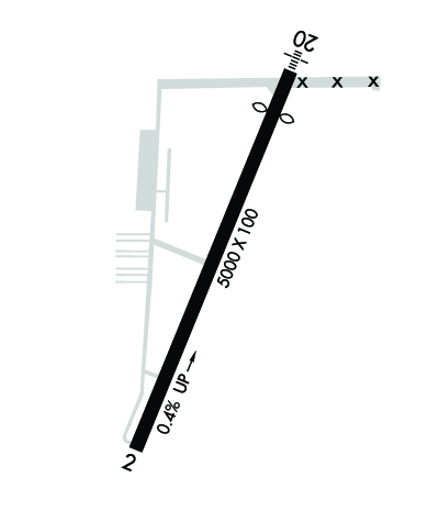
| Lat: N 3935.3 Long: W 08413.5 Elev: 957 Var: +04 Longest Runway: 5000 | ||
| Clr Del: 119.4 AWOS: 118.37 CTAF: 122.8 | ||
| ||||||||||||||||||||||||||||||||||||||||||||
| ||||||||||||||||||||||||||||||||||||||||||||
| ||||||||||||||||||||||||||||||||||||||||||||
| Rwy | Rwy | |||||||
| 5000x100 | 5000' | 5000x100 | 4410' | 109.50 - 206° | ||||
| Runway ID | Single Wheel | Double Wheel | Double Tandem Wheel | Dual Double Wheel |
| 02/20 | 50,000 | 60,000 | N/A | N/A |
| These numbers are Advisory and are not limits. The Airport Manager should have more accurate Weight Limits | ||||
 Airport Diagram might not be current. | |
| Facility Name: | DAYTON/WRIGHT BROTHERS |
| City Name: | DAYTON |
| County: | MONTGOMERY |
| State abbrev: | OH |
| State Name: | OHIO |
| Ownership: | PUBLICLY OWNED |
| Use: | OPEN TO THE PUBLIC |
| Owner's Name: | CITY OF DAYTON |
| Address: | 101 W 3RD ST |
| DAYTON, OH 45402-1859 | |
| Owner's Phone: | 937-333-3600 |
| Manager's Name: | BRANDON ELLIS |
| Address: | 3600 TERMINAL DR STE 300 |
| VANDALIA, OH 45377-1095 | |
| Phone: | 937-454-7897; CELL 937-776-2194. |
| FAA Region: | GREAT LAKES |
| FAA Field Office: | DET |
| Date | Sunrise | Sunset |
|---|---|---|
| 06/08/26 Monday | 6:09 | 21:03 |
| 06/09/26 Tuesday | 6:09 | 21:03 |
| 06/10/26 Wednesday | 6:09 | 21:04 |
| 06/11/26 Thursday | 6:09 | 21:04 |
| 06/12/26 Friday | 6:09 | 21:05 |
| 06/13/26 Saturday | 6:09 | 21:05 |
| 06/14/26 Sunday | 6:09 | 21:06 |
| 06/15/26 Monday | 6:09 | 21:06 |
| 06/16/26 Tuesday | 6:09 | 21:06 |
| 06/17/26 Wednesday | 6:09 | 21:07 |
| 06/18/26 Thursday | 6:09 | 21:07 |
| 06/19/26 Friday | 6:09 | 21:07 |
| 06/20/26 Saturday | 6:09 | 21:08 |
| 06/21/26 Sunday | 6:09 | 21:08 |
| Airport Attendance Schedule | 7 Days A Week 0700-2000 |
| Airport Status | OPERATIONAL (This Status can change at any time - please check NOTAMS) |
| Airport Lighting Schedule | ACTVT MALS RWY 20; PAPI RWY 02 & 20; MIRL RWY 02/20 - CTAF. TWY LGTS OPR CONSLY SS-SR. |
| Airport Storage Available | Tie Downs, Hanger |
| Extra Services Available | Air Freight, Cargo Handling, Charter, Flight Instruction, Aircraft Rental, Aircraft Sales |
| Wind Indicator | YES - (lighted) |
| Control Tower | NO |
| CTAF Frequency | 122.800 |
| Unicom Frequency | 122.800 |
| Rotating Beacon Color | WG |
| Segmented Circle | NO |
| Landing Fee | NO |
| Airport Inspected | STATE - performed by STATE AERONAUTICAL PERSONNEL |
| Inspection Date | 09/08/2022 |
| Type of Fuel Available | Grade 100LL, JET A (freeze point -40C), JET A |
| Airframe Repair Service | MAJOR |
| Power Plant Repair Service | MAJOR |
| Latitude | N3935.3 |
| Longitude | W08413.5 (ESTIMATED) |
| Arpt Elevation | 956ft (SURVEYED) |
| Magnetic Variation | 04W |
| 10 miles S | of DAYTON |
| Traffic Pattern Altitude | |
| Sectional Chart | CINCINNATI |
| Operations (Reported) | Yearly | Avg. Daily |
|---|---|---|
| General Aviation Transient | 0 | 0 |
| General Aviation Local | 0 | 0 |
| Air Taxi | 0 | 0 |
| Commerical | 0 | 0 |
| Commuter | 0 | 0 |
| Military | 0 | 0 |
| Aircraft based on Field | |
|---|---|
| General Aviation Singles | 0 |
| General Aviation Multi | 0 |
| Jet Aircraft | 0 |
| General Aviation Helicopters | 0 |
| Military Aircraft | 0 |
| Gliders | 0 |
| Ultralights | 0 |
| FSS on field | NO |
| FSS tie-in | DAYTON |
| FSS Phone | 1-800-WX-BRIEF |
| Who issues Notams | MGY |
| Notam D service at airport | YES |
| ARTCC Name | INDIANAPOLIS |
| Airport Certification | |
| Aircraft Rescue & Firefighting Index | None |
| Airport of Entry | No |
| Custom Landing Rights | No |
| Joint Civil/Military | No |
| Military Landing rights | YES |
| NATIONAL PLAN OF INTEGRATED AIRPORT SYSTEMS (NPIAS) |
| GRANT AGREEMENTS UNDER FAAP/ADAP/AIP |
| ASSURANCES PURSUANT TO TITLE VI, CIVIL RIGHTS ACT OF 1964 |
| THIS AIRPORT HAS BEEN SURVEYED BY THE NATIONAL GEODETIC SURVEY. |
| DEER, BIRDS, & OTR WILDLIFE ON & INVOF ARPT. |
| SFC CONDS UNMON 1530-0700 WKDAYS & ALL DAY WKENDS/HOLS. |
| FULL PWR MAINT RUNUPS PROHIBITED IN THE HLDG APN AT THE NW CORNER OF TWY A 0800-1700 WKDAYS. |
Airport Communications & Frequencies:
| ||||||||||||||||
| Runway: 02 | Runway: 20 | ||
| Mag heading: | 26° | Mag heading: | 206° |
| Rwy Slope: | .41% Up | Rwy Slope: | -.41% Down |
| Approach: | Approach: | LOC/DME | |
| Pattern: | Left Traffic | Pattern: | Left Traffic |
| Markings: | NONPRECISION INSTRUMENT | Markings: | NONPRECISION INSTRUMENT |
| Marking Condition: | FAIR | Marking Condition: | FAIR |
| Arresting Dev: | Arresting Dev: | ||
| Lat & Long: | N3935.0 W08413.7 | Lat. & Long.: | N3935.7 W08413.3 |
| Elev: | 936.2 ft. MSL | Elev: | 956.6 ft. MSL |
| TCH: | 49 ft. AGL | TCH: | 39 ft. AGL |
| Visual Glide Path: | 3.00 degrees | Visual Glide Path: | 3.00 degrees |
| Displaced Threshold: | No | Displaced Threshold: | 590 feet |
| Touchdown Zone: | YES | Touchdown Zone: | YES |
| Touchdown Elev.: | 948.7 feet | Touchdown Elev.: | 955.1 feet |
| Visual Glide Slope: | 2-Light PAPI on LEFT side of Runway | Visual Glide Slope: | 4-Light PAPI on LEFT side of Runway; PAPI UNUSBL BYD 7 DEGS RIGHT OF CNTRLN. |
| RVR Equipment: | RVR Equipment: | ||
| RVV Equipment: | NO | RVV Equipment: | NO |
| Approach Lights: | Approach Lights: | MALS - 1,400 foot medium intensity approach lighting system | |
| REIL: | NO | REIL: | NO |
| Centerline Lights: | NO | Centerline Lights: | NO |
| Touchdown lights: | NO | Touchdown lights: | NO |
| Runway Category: | Runway with a Non-precision Approach having visibility minimums greater than 3/4 mile | Runway Category: | Runway with a Non-precision Approach having visibility minimums greater than 3/4 mile |
| Declared Distances: | TORA:5000' TODA:5000' ASDA:4700' LDA:4700' | Declared Distances: | TORA:5000' TODA:5000' ASDA:5000' LDA:4410' |
| Obstructions: | Obstructions: | ROAD | |
| Marked: | Marked: | NOT Marked/Lighted | |
| Clearance slope: | 34:1 | Clearance slope: | 13:1; APCH SLP 34:1 TO DTHR. |
| Obstruction height: | Obstruction height: | 25 feet AGL | |
| Dist. from runway: | Dist. from runway: | 540 feet | |
| Centerline offset: | Centerline offset: | 300 feet right of centerline | |
| Comments: | Comments: |
Thanks for using FltPlan.com
all rights reserved © 1999-2026 by Flight Plan LLC
