
| MONTGOMERY RGNL (DANNELLY FIEL MONTGOMERY AL |
| |
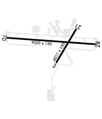
| Lat: N 3218.0 Long: W 08623.6 Elev: 232 Var: +01 Longest Runway: 9020 | ||
| Clr Del: 118.3 Dept. ATIS: 120.67 Arr. ATIS: 120.67 Ground: 121.7 Tower: 119.7 | ||
| ||||||||||||||||||||||||||||||||||||||||||||
| ||||||||||||||||||||||||||||||||||||||||||||
| ||||||||||||||||||||||||||||||||||||||||||||
| Rwy | Rwy | |||||||
| 4011x150 | 4011' | 4011x150 | 4011' | |||||
| 9020x150 | 9020' | 109.90 - 097° | 9020x150 | 9020' | 108.50 - 277° | |||
| Runway ID | Single Wheel | Double Wheel | Double Tandem Wheel | Dual Double Wheel |
| 03/21 | 40,000 | 95,000 | N/A | N/A |
| 10/28 | 105,000 | 116,000 | 180,000 | N/A |
| H1 | N/A | N/A | N/A | N/A |
| These numbers are Advisory and are not limits. The Airport Manager should have more accurate Weight Limits | ||||
 Airport Diagram might not be current. | |
| Facility Name: | MONTGOMERY RGNL (DANNELLY FLD) |
| City Name: | MONTGOMERY |
| County: | MONTGOMERY |
| State abbrev: | AL |
| State Name: | ALABAMA |
| Ownership: | PUBLICLY OWNED |
| Use: | OPEN TO THE PUBLIC |
| Owner's Name: | MONTGOMERY AIRPORT AUTHORITY |
| Address: | 4445 SELMA HWY |
| MONTGOMERY, AL 36108 | |
| Owner's Phone: | 334-281-5040 |
| Manager's Name: | LOYD JENKINS |
| Address: | 4445 SELMA HWY |
| MONTGOMERY, AL 36108 | |
| Phone: | 334-281-5040 |
| FAA Region: | SOUTHERN |
| FAA Field Office: | JAN |

| Date | Sunrise | Sunset |
|---|---|---|
| 06/07/26 Sunday | 5:38 | 19:51 |
| 06/08/26 Monday | 5:38 | 19:51 |
| 06/09/26 Tuesday | 5:38 | 19:51 |
| 06/10/26 Wednesday | 5:38 | 19:52 |
| 06/11/26 Thursday | 5:38 | 19:52 |
| 06/12/26 Friday | 5:38 | 19:53 |
| 06/13/26 Saturday | 5:38 | 19:53 |
| 06/14/26 Sunday | 5:38 | 19:53 |
| 06/15/26 Monday | 5:38 | 19:54 |
| 06/16/26 Tuesday | 5:38 | 19:54 |
| 06/17/26 Wednesday | 5:38 | 19:54 |
| 06/18/26 Thursday | 5:39 | 19:55 |
| 06/19/26 Friday | 5:39 | 19:55 |
| 06/20/26 Saturday | 5:39 | 19:55 |
| Airport Attendance Schedule | CONTINUOUS |
| Airport Status | OPERATIONAL (This Status can change at any time - please check NOTAMS) |
| Airport Lighting Schedule | WHEN ATCT CLSD HIRL RWY 10/28 PRESET MED INTST, MIRL RWY 03/21 PRESET LOW INTST. PAPI RWYS 03, 21, 10, & 28 OPR CONSLY. ACTVT MALSR RWYS 10 & 28; REIL RWY 03 - CTAF. |
| Airport Storage Available | Tie Downs, Hanger |
| Extra Services Available | Air Freight, Avionics, Cargo Handling, Charter, Flight Instruction, Aircraft Rental, Aircraft Sales |
| Wind Indicator | YES - (lighted) |
| Control Tower | YES |
| CTAF Frequency | 119.700 |
| Unicom Frequency | 122.950 |
| Rotating Beacon Color | WG |
| Segmented Circle | YES |
| Landing Fee | NO |
| Airport Inspected | FEDERAL - performed by FAA AIRPORTS FIELD PERSONNEL |
| Inspection Date | 12/12/2025 |
| Type of Fuel Available | Grade 100LL, JET A (freeze point -40C)A++; -A SERVICE-FUEL: ( A++100 (MIL)). |
| Airframe Repair Service | MAJOR |
| Power Plant Repair Service | MAJOR |
| Latitude | N3218.0 |
| Longitude | W08623.6 (ESTIMATED) |
| Arpt Elevation | 221ft (SURVEYED) |
| Magnetic Variation | 01W |
| 6 miles SW | of MONTGOMERY |
| Traffic Pattern Altitude | 1200; TPA: 1200 FT AGL CONV ACFT, 1700 FT AGL JET ACFT. |
| Sectional Chart | ATLANTA |
| Operations (Reported) | Yearly | Avg. Daily |
|---|---|---|
| General Aviation Transient | 0 | 0 |
| General Aviation Local | 0 | 0 |
| Air Taxi | 0 | 0 |
| Commerical | 0 | 0 |
| Commuter | 0 | 0 |
| Military | 0 | 0 |
| Aircraft based on Field | |
|---|---|
| General Aviation Singles | 0 |
| General Aviation Multi | 0 |
| Jet Aircraft | 0 |
| General Aviation Helicopters | 0 |
| Military Aircraft | 0 |
| Gliders | 0 |
| Ultralights | 0 |
| FSS on field | NO |
| FSS tie-in | ANNISTON |
| FSS Phone | 1-800-WX-BRIEF |
| Who issues Notams | MGM |
| Notam D service at airport | YES |
| ARTCC Name | ATLANTA |
| Airport Certification | AIRPORT RECEIVING SCHEDULED AIR CARRIER SERVICE FROM CARRIERS CERTIFICATED BY THE CIVIL AERONAUTICS BOARD; CLSD TO UNSKED ACR OPNS & LRG MIL ACFT REQUIRING PARKING, EXCP WITH 72 HRS PPR CTC AMGR 334-281-5040. |
| Aircraft Rescue & Firefighting Index | AIRPORT HAS A CERTIFICATE UNDER CFR PART 139 |
| Airport of Entry | No |
| Custom Landing Rights | No |
| Joint Civil/Military | No; ALABAMA ANG ONLY. |
| Military Landing rights | YES |
| NATIONAL PLAN OF INTEGRATED AIRPORT SYSTEMS (NPIAS) |
| GRANT AGREEMENTS UNDER FAAP/ADAP/AIP |
| ASSURANCES PURSUANT TO TITLE VI, CIVIL RIGHTS ACT OF 1964 |
| AGREEMENT UNDER DLAND OR DCLA HAS EXPIRED. |
| NO 180 DEG TURNS ON RWY 10/28 BY DC-9 OR LARGER ACFT. |
| ACR & LRG MIL ACFT SHOULD NOT TAXI ON RWY 03/21. |
| MILITARY: BIRD HAZARD. CTC BASE OPS ON 360.975 FOR CURRENT BIRD WATCH COND. BASH PHASE II BIRD ACT IS DURG APR AND FM 1 SEP TO 31 DEC. |
| ARNG - F/W ACFT INBD TO ARNG RAMP CTC ARNG 10MIN PRIOR TO ETA AND UPON ENTY TWY D. L-3 (C-12)MAINT AVBL ON CALL, C334-280-4890 COMMUNICATIONS. |
| MILITARY: ANG: ONGOING CONSTR ON RAMP. CTC BASE OPS FOR TAX/PRKG INSTRNS DSN 358-9255 OR C334-394-7255. |
| ANG: RWY CC NOT RPT. |
| FOR CD IF UNA TO CTC ON FSS FREQ, CTC DANNELLY APCH AT 334-284-4575, WHEN ATCT CLSD CTC ATLANTA ARTCC AT 770-210-7692. |
| MILITARY: FLUID: LHNIT. |
| MILITARY: OIL: JOAP. |
| ANG RAMP - REDUCED WINGTIP CLEARANCE FOR PARKING SPOTS 11-16 WHEN F-35 LIGHTNING PROTECTION SYSTEMS IN USE. |
| RSTD - TWY E 35' WIDE, MIL ACFT RSTD FM USE. |
| CAUTION: DO NOT MISTAKE MAXWELL AFB - 6 NM NORTH FOR MONGOMERY RGNL. NUMEROUS HEL AND LOW SPEED ACFT INVOF ARPT DURG DALGT HRS. |
| ARNG: ANG RAMP CONST WIP. CTC AFLD MGMT FOR TAXI INSTR. TRANSPORT ACFT LTD TO MIN THRUST WHILE ON ANG RAMP. CONES BLOCKING THROAT OF ANG RAMP. CTC BASE OPS PRIOR TO ENTERING ANG RAMP FOR REMOVAL. INBD FOR ANG CTC BAMA OPS 15 MIN PRIOR LDG. ACFT PARKING EXTREMELY LMTD CTC BASE OPNS FOR PARKING INSTR. TSNT PARKING EXTREMELY LIMITED. PPR FOR USE OF ANG RAMP CTC ANG OPNS DSN358-9255/9256/C334-394-7255/7256. ANG BASE OPS FACILITY AVBL 1200-2230Z++. |
| RWY 03/2 1 RWY 03/21 NOT AVBL FOR PART 121/PART 380 OPS WITH SKED PAX CARRYING OPS MORE THAN 9 PAX SEATS AND NON-SKED PAX CARRYING OPS MORE THAN 30 PAX SEATS. |
| RWY 10/2 8 MILITARY: RWY 10 AND RWY 28 BAK-12B(B) AVBL WITH 30 MIN PN 1200-0500Z++. 8 PT TIE-DOWNS ON BAK-12B(B). RAISED CABLE ON ATIS BCST. |
| RWY 10/2 8 DC-10-10 320; DC-10-30 & 40 400; L1011 350; B747 500. |
| RWY 03/2 1 PCR VALUE: 150/F/A/X/T |
| RWY 10/2 8 PCR VALUE: 600/F/A/X/T |
Airport Communications & Frequencies:
| |||||||||||||||||||||||||||||||||||||||||||||
| Runway: 03 | Runway: 21 | ||
| Mag heading: | 34° | Mag heading: | 214° |
| Rwy Slope: | -.86% Down | Rwy Slope: | .86% Up |
| Approach: | Approach: | ||
| Pattern: | Left Traffic | Pattern: | Left Traffic |
| Markings: | NONPRECISION INSTRUMENT | Markings: | NONPRECISION INSTRUMENT |
| Marking Condition: | GOOD | Marking Condition: | GOOD |
| Arresting Dev: | Arresting Dev: | ||
| Lat & Long: | N3217.7 W08623.6 | Lat. & Long.: | N3218.3 W08623.2 |
| Elev: | 221.1 ft. MSL | Elev: | 186.5 ft. MSL |
| TCH: | 43 ft. AGL | TCH: | 55 ft. AGL |
| Visual Glide Path: | 3.00 degrees | Visual Glide Path: | 3.00 degrees |
| Displaced Threshold: | No | Displaced Threshold: | No |
| Touchdown Zone: | YES | Touchdown Zone: | YES |
| Touchdown Elev.: | 221.1 feet | Touchdown Elev.: | 206.3 feet |
| Visual Glide Slope: | 4-Light PAPI on LEFT side of Runway | Visual Glide Slope: | 4-Light PAPI on LEFT side of Runway |
| RVR Equipment: | RVR Equipment: | ||
| RVV Equipment: | NO | RVV Equipment: | NO |
| Approach Lights: | Approach Lights: | ||
| REIL: | YES | REIL: | NO |
| Centerline Lights: | NO | Centerline Lights: | NO |
| Touchdown lights: | NO | Touchdown lights: | NO |
| Runway Category: | Runway with a Non-precision Approach having visibility minimums greater than 3/4 mile | Runway Category: | Runway with a Visual Approach |
| Declared Distances: | Declared Distances: | ||
| Obstructions: | FENCE | Obstructions: | TREE |
| Marked: | NOT Marked/Lighted | Marked: | NOT Marked/Lighted |
| Clearance slope: | 22:1 | Clearance slope: | 20:1 |
| Obstruction height: | 22 feet AGL | Obstruction height: | 54 feet AGL |
| Dist. from runway: | 700 feet | Dist. from runway: | 1300 feet |
| Centerline offset: | Centerline offset: | 300 feet left of centerline | |
| Comments: | Comments: |
| Runway: 10 | Runway: 28 | ||
| Mag heading: | 97° | Mag heading: | 277° |
| Rwy Slope: | -.26% Down | Rwy Slope: | .26% Up |
| Approach: | ILS | Approach: | ILS |
| Pattern: | Right Traffic | Pattern: | Left Traffic |
| Markings: | PRECISION INSTRUMENT | Markings: | PRECISION INSTRUMENT |
| Marking Condition: | GOOD | Marking Condition: | GOOD |
| Arresting Dev: | BAK-12B; HOOK BAK-12B(B) (1500 FT). | Arresting Dev: | BAK-12B; HOOK BAK-12B(B) (1510 FT). |
| Lat & Long: | N3218.1 W08624.6 | Lat. & Long.: | N3218.0 W08622.9 |
| Elev: | 219.3 ft. MSL | Elev: | 195.5 ft. MSL |
| TCH: | 64 ft. AGL | TCH: | 75 ft. AGL |
| Visual Glide Path: | 3.00 degrees | Visual Glide Path: | 3.00 degrees |
| Displaced Threshold: | No | Displaced Threshold: | No |
| Touchdown Zone: | YES | Touchdown Zone: | YES |
| Touchdown Elev.: | 219.3 feet | Touchdown Elev.: | 196.7 feet |
| Visual Glide Slope: | 4-Light PAPI on RIGHT side of Runway | Visual Glide Slope: | 4-Light PAPI on LEFT side of Runway |
| RVR Equipment: | TOUCHDOWN | RVR Equipment: | ROLLOUT |
| RVV Equipment: | NO | RVV Equipment: | NO |
| Approach Lights: | MALSR - 1,400 foot medium intensity approach lighting system with runway alignment indicator lights | Approach Lights: | MALSR - 1,400 foot medium intensity approach lighting system with runway alignment indicator lights |
| REIL: | NO | REIL: | NO |
| Centerline Lights: | NO | Centerline Lights: | NO |
| Touchdown lights: | NO | Touchdown lights: | NO |
| Runway Category: | Precision Instrument Runway | Runway Category: | Precision Instrument Runway |
| Declared Distances: | Declared Distances: | ||
| Obstructions: | TREE | Obstructions: | TREE |
| Marked: | NOT Marked/Lighted | Marked: | NOT Marked/Lighted |
| Clearance slope: | 34:1 | Clearance slope: | 40:1 |
| Obstruction height: | 35 feet AGL | Obstruction height: | 65 feet AGL |
| Dist. from runway: | 1990 feet | Dist. from runway: | 2800 feet |
| Centerline offset: | 630 left of centerline | Centerline offset: | 600 feet right of centerline |
| Comments: | Comments: |
Thanks for using FltPlan.com
all rights reserved © 1999-2026 by Flight Plan LLC