
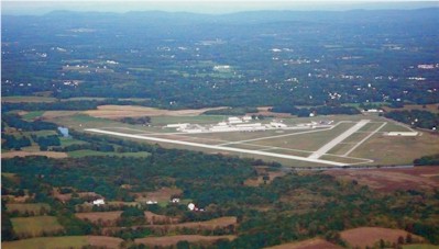
| ORANGE COUNTY MONTGOMERY NY |
| |
| Lat: N 4130.7 Long: W 07415.8 Elev: 370 Var: +14 Longest Runway: 5006 | ||
| Clr Del: 123.85 AWOS: 119.27 CTAF: 122.72 | ||
| ||||||||||||||||||||||||||||||||||||||||||||
| ||||||||||||||||||||||||||||||||||||||||||||
| ||||||||||||||||||||||||||||||||||||||||||||
| Rwy | Rwy | |||||||
| 5006x100 | 5006' | 111.70 - 029° | 5006x100 | 5006' | ||||
| 3664x100 | 3664' | 3664x100 | 3349' | |||||
| Runway ID | Single Wheel | Double Wheel | Double Tandem Wheel | Dual Double Wheel |
| 04/22 | 30,000 | 57,000 | 85,000 | N/A |
| 08/26 | 30,000 | 57,000 | 85,000 | N/A |
| These numbers are Advisory and are not limits. The Airport Manager should have more accurate Weight Limits | ||||
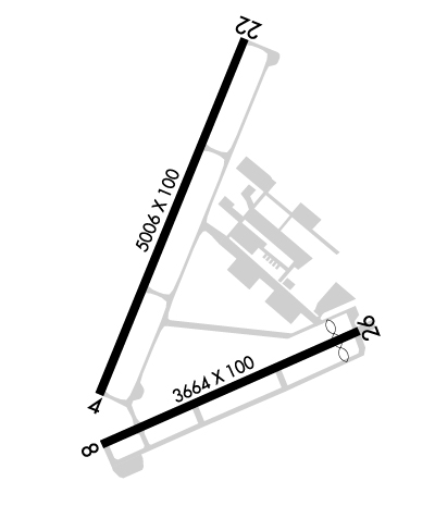 Airport Diagram might not be current. | |
| Facility Name: | ORANGE COUNTY |
| City Name: | MONTGOMERY |
| County: | ORANGE |
| State abbrev: | NY |
| State Name: | NEW YORK |
| Ownership: | PUBLICLY OWNED |
| Use: | OPEN TO THE PUBLIC |
| Owner's Name: | ORANGE COUNTY |
| Address: | 255 MAIN STREET |
| GOSHEN, NY 10924 | |
| Owner's Phone: | 845-291-4000 |
| Manager's Name: | EDWARD MAGRYTA |
| Address: | 500 DUNN RD. |
| MONTGOMERY, NY 12549-2402 | |
| Phone: | 845-457-4925 |
| FAA Region: | EASTERN |
| FAA Field Office: | NYC |
| Date | Sunrise | Sunset |
|---|---|---|
| 09/24/21 Friday | 6:46 | 18:51 |
| 09/25/21 Saturday | 6:47 | 18:50 |
| 09/26/21 Sunday | 6:48 | 18:48 |
| 09/27/21 Monday | 6:49 | 18:46 |
| 09/28/21 Tuesday | 6:50 | 18:44 |
| 09/29/21 Wednesday | 6:51 | 18:43 |
| 09/30/21 Thursday | 6:52 | 18:41 |
| 10/01/21 Friday | 6:54 | 18:39 |
| 10/02/21 Saturday | 6:55 | 18:38 |
| 10/03/21 Sunday | 6:56 | 18:36 |
| 10/04/21 Monday | 6:57 | 18:34 |
| 10/05/21 Tuesday | 6:58 | 18:33 |
| 10/06/21 Wednesday | 6:59 | 18:31 |
| 10/07/21 Thursday | 7:00 | 18:29 |
| Airport Attendance Schedule | SUN 0830-1630, NOV--APR MON-SAT 0700-1700, MAY-OCT MON-SAT 0700-1900 |
| Airport Status | OPERATIONAL (This Status can change at any time - please check NOTAMS) |
| Airport Lighting Schedule | ACTVT HIRL RWY 04/22; MIRL RWY 08/26; TWY LGTS - CTAF. REIL RWY 04 & 22; PAPI RWYS 04 & 22; 08 & 26 OPR CONSLY. PCL ONLY AVBL SS-SR. |
| Airport Storage Available | Hanger |
| Extra Services Available | Charter, Flight Instruction |
| Wind Indicator | YES - (lighted) |
| Control Tower | NO |
| CTAF Frequency | 122.725 |
| Unicom Frequency | 122.725; AUTOMATED UNICOM. |
| Rotating Beacon Color | CLEAR-GREEN (Light Land Airport) |
| Segmented Circle | YES |
| Landing Fee | NO |
| Airport Inspected | STATE - performed by STATE AERONAUTICAL PERSONNEL |
| Inspection Date | 09/05/2019 |
| Type of Fuel Available | Grade 100LL, JET A (freeze point -40C) |
| Airframe Repair Service | MAJOR |
| Power Plant Repair Service | MAJOR |
| Latitude | N4130.7 |
| Longitude | W07415.8 (ESTIMATED) |
| Arpt Elevation | 370ft (SURVEYED) |
| Magnetic Variation | 14W |
| 1 miles SW | of MONTGOMERY |
| Traffic Pattern Altitude | TPA: 1400 FT AGL SINGL ENG, 1700 FT AGL MULT ENG/TURBOPROP/JET. |
| Sectional Chart | NEW YORK |
| Operations (Reported) | Yearly | Avg. Daily |
|---|---|---|
| General Aviation Transient | 49554 | 136 |
| General Aviation Local | 66246 | 181 |
| Air Taxi | 2600 | 7 |
| Commerical | 0 | 0 |
| Commuter | 0 | 0 |
| Military | 500 | 1 |
| Aircraft based on Field | |
|---|---|
| General Aviation Singles | 136 |
| General Aviation Multi | 15 |
| Jet Aircraft | 4 |
| General Aviation Helicopters | 1 |
| Military Aircraft | 0 |
| Gliders | 3 |
| Ultralights | 1 |
| FSS on field | NO |
| FSS tie-in | NEW YORK |
| FSS Phone | 1-800-WX-BRIEF |
| Who issues Notams | MGJ |
| Notam D service at airport | YES |
| ARTCC Name | NEW YORK |
| Airport Certification | |
| Aircraft Rescue & Firefighting Index | None |
| Airport of Entry | No |
| Custom Landing Rights | No |
| Joint Civil/Military | No |
| Military Landing rights | YES |
| NATIONAL PLAN OF INTEGRATED AIRPORT SYSTEMS (NPIAS) |
| GRANT AGREEMENTS UNDER FAAP/ADAP/AIP |
| SURPLUS PROPERTY AGREEMENT UNDER PUBLIC LAW 289 |
| ASSURANCES PURSUANT TO TITLE VI, CIVIL RIGHTS ACT OF 1964 |
| 9 FT STABILIZED SHOULDER EACH SIDE OF RWY 8/26. |
| FUEL AVAIL. AFT HRS BY CREDIT CARD SELF-SVC RAMP. |
| DEER AND BIRDS ON AND INVOF ARPT. |
| RWY 04 DESGND CALM WIND RWY. |
| FOR CD CTC NEW YORK APCH AT 516-683-2448 OR 123.85 |
| RWY 04-22 HIRLS ON PHOTOCELL DRG DAY, ON REMOTE AT NGT. |
| NOISE ABATEMENT PROCEDURES IN EFCT; CTC AMGR 845-457-4925. |
| BE AWARE OF LRG TBJT ACFT INVOF STEWART ARPT LCTD 7 NM ESE. 800 FT HILL 1/2 MILE NW OF ARPT ON DOWNWIND/BASE LEG FOR RWY 22. |
| SAWRS |
Airport Communications & Frequencies:
| ||||||||||||||||
| Runway: 04 | Runway: 22 | ||
| Mag heading: | 36° | Mag heading: | 216° |
| Rwy Slope: | .30% Up | Rwy Slope: | -.30% Down |
| Approach: | ILS | Approach: | |
| Pattern: | Left Traffic | Pattern: | Right Traffic |
| Markings: | PRECISION INSTRUMENT | Markings: | PRECISION INSTRUMENT |
| Marking Condition: | GOOD | Marking Condition: | GOOD |
| Arresting Dev: | Arresting Dev: | ||
| Lat & Long: | N4130.5 W07416.1 | Lat. & Long.: | N4131.2 W07415.7 |
| Elev: | 355.0 ft. MSL | Elev: | 370.0 ft. MSL |
| TCH: | 52 ft. AGL | TCH: | 45 ft. AGL |
| Visual Glide Path: | 3.00 degrees | Visual Glide Path: | 3.00 degrees |
| Displaced Threshold: | No | Displaced Threshold: | No |
| Touchdown Zone: | YES | Touchdown Zone: | YES |
| Touchdown Elev.: | 355.0 feet | Touchdown Elev.: | 370.0 feet |
| Visual Glide Slope: | 4-Light PAPI on LEFT side of Runway | Visual Glide Slope: | 2-Light PAPI on LEFT side of Runway |
| RVR Equipment: | RVR Equipment: | ||
| RVV Equipment: | NO | RVV Equipment: | NO |
| Approach Lights: | Approach Lights: | ||
| REIL: | YES | REIL: | YES |
| Centerline Lights: | NO | Centerline Lights: | NO |
| Touchdown lights: | NO | Touchdown lights: | NO |
| Runway Category: | Precision Instrument Runway | Runway Category: | Runway with a Non-precision Approach having visibility minimums greater than 3/4 mile |
| Declared Distances: | Declared Distances: | ||
| Obstructions: | TREES | Obstructions: | |
| Marked: | NOT Marked/Lighted | Marked: | |
| Clearance slope: | 7:1 | Clearance slope: | 34:1 |
| Obstruction height: | 49 feet AGL | Obstruction height: | |
| Dist. from runway: | 560 feet | Dist. from runway: | |
| Centerline offset: | 533 left of centerline | Centerline offset: | |
| Comments: | Comments: |
| Runway: 08 | Runway: 26 | ||
| Mag heading: | 80° | Mag heading: | 260° |
| Rwy Slope: | .33% Up | Rwy Slope: | -.33% Down |
| Approach: | Approach: | ||
| Pattern: | Left Traffic | Pattern: | Right Traffic |
| Markings: | NONPRECISION INSTRUMENT | Markings: | PRECISION INSTRUMENT |
| Marking Condition: | GOOD | Marking Condition: | GOOD |
| Arresting Dev: | Arresting Dev: | ||
| Lat & Long: | N4130.4 W07416.1 | Lat. & Long.: | N4130.6 W07415.3 |
| Elev: | 352.0 ft. MSL | Elev: | 364.0 ft. MSL |
| TCH: | 49 ft. AGL | TCH: | 43 ft. AGL |
| Visual Glide Path: | 3.50 degrees | Visual Glide Path: | 3.50 degrees |
| Displaced Threshold: | No | Displaced Threshold: | 315 feet |
| Touchdown Zone: | YES | Touchdown Zone: | YES |
| Touchdown Elev.: | 358.8 feet | Touchdown Elev.: | 360.6 feet |
| Visual Glide Slope: | 2-Light PAPI on LEFT side of Runway | Visual Glide Slope: | 2-Light PAPI on LEFT side of Runway |
| RVR Equipment: | RVR Equipment: | ||
| RVV Equipment: | NO | RVV Equipment: | NO |
| Approach Lights: | Approach Lights: | ||
| REIL: | NO | REIL: | NO |
| Centerline Lights: | NO | Centerline Lights: | NO |
| Touchdown lights: | NO | Touchdown lights: | NO |
| Runway Category: | Runway with a Non-precision Approach | Runway Category: | Runway with a Non-precision Approach |
| Declared Distances: | Declared Distances: | ||
| Obstructions: | TREES | Obstructions: | FENCE |
| Marked: | NOT Marked/Lighted | Marked: | NOT Marked/Lighted |
| Clearance slope: | 23:1 | Clearance slope: | RWY 26 APCH SLOPE 11:1 DUE TO 56 FT TREE 644 FT FM DTHR. |
| Obstruction height: | 69 feet AGL | Obstruction height: | 15 feet AGL |
| Dist. from runway: | 1788 feet | Dist. from runway: | 200 feet |
| Centerline offset: | 28 right of centerline | Centerline offset: | 250 feet left of centerline |
| Comments: | Comments: |
Thanks for using FltPlan.com
all rights reserved © 1999-2021 by Flight Plan LLC