| MICHIGAN CITY MUNI MICHIGAN CITY IN |
| |
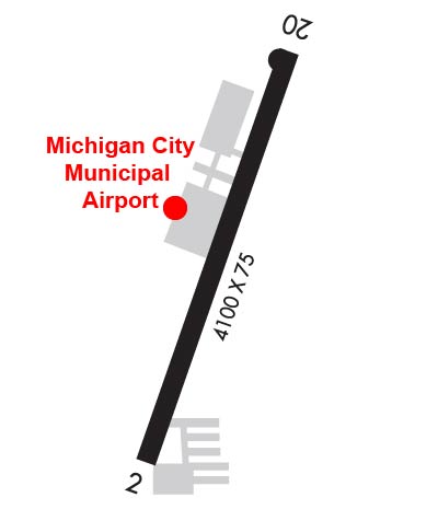
| Lat: N 4142.2 Long: W 08649.3 Elev: 655 Var: +03 Longest Runway: 4099 | ||
| Clr Del: 118.625 AWOS: 128.45 CTAF: 122.7 | ||
| |||||||||||||||||||||||||||||||||||||||||||||||||||||||||||||||||||||
| |||||||||||||||||||||||||||||||||||||||||||||||||||||||||||||||||||||
| |||||||||||||||||||||||||||||||||||||||||||||||||||||||||||||||||||||
| Rwy | Rwy | |||||||
| 4099x75 | 3757' | 4099x75 | 3916' | |||||
| Runway ID | Single Wheel | Double Wheel | Double Tandem Wheel | Dual Double Wheel |
| 02/20 | N/A | N/A | N/A | N/A |
| These numbers are Advisory and are not limits. The Airport Manager should have more accurate Weight Limits | ||||
 Airport Diagram might not be current. | |
| Facility Name: | MICHIGAN CITY MUNI-PHILLIPS FLD |
| City Name: | MICHIGAN CITY |
| County: | LA PORTE |
| State abbrev: | IN |
| State Name: | INDIANA |
| Ownership: | PUBLICLY OWNED |
| Use: | OPEN TO THE PUBLIC |
| Owner's Name: | MICHIGAN CITY BOAC; GREG POULIN |
| Address: | 1300 N HWY 212 |
| MICHIGAN CITY, IN 46360 | |
| Owner's Phone: | 219-872-0121 |
| Manager's Name: | JESSICA WARD |
| Address: | 1300 N HIGHWAY 212 |
| MICHIGAN CITY, IN 46360 | |
| Phone: | 219-872-0121; EMERG - 219-898-1277 |
| FAA Region: | GREAT LAKES |
| FAA Field Office: | CHI |
| Date | Sunrise | Sunset |
|---|---|---|
| 09/24/21 Friday | 6:36 | 18:41 |
| 09/25/21 Saturday | 6:38 | 18:40 |
| 09/26/21 Sunday | 6:39 | 18:38 |
| 09/27/21 Monday | 6:40 | 18:36 |
| 09/28/21 Tuesday | 6:41 | 18:35 |
| 09/29/21 Wednesday | 6:42 | 18:33 |
| 09/30/21 Thursday | 6:43 | 18:31 |
| 10/01/21 Friday | 6:44 | 18:29 |
| 10/02/21 Saturday | 6:45 | 18:28 |
| 10/03/21 Sunday | 6:46 | 18:26 |
| 10/04/21 Monday | 6:47 | 18:24 |
| 10/05/21 Tuesday | 6:48 | 18:23 |
| 10/06/21 Wednesday | 6:49 | 18:21 |
| 10/07/21 Thursday | 6:50 | 18:19 |
| Airport Attendance Schedule | 7 Days A Week 0800-1700 |
| Airport Status | OPERATIONAL (This Status can change at any time - please check NOTAMS) |
| Airport Lighting Schedule | ACTVT REIL RWY 20; MIRL RWY 02/20 - CTAF. |
| Airport Storage Available | Tie Downs, Hanger |
| Extra Services Available | Parachute Jumping |
| Wind Indicator | YES - (lighted) |
| Control Tower | NO |
| CTAF Frequency | 122.700 |
| Unicom Frequency | 122.700 |
| Rotating Beacon Color | CLEAR-GREEN (Light Land Airport) |
| Segmented Circle | YES |
| Landing Fee | NO |
| Airport Inspected | STATE - performed by STATE AERONAUTICAL PERSONNEL |
| Inspection Date | 06/15/2021 |
| Type of Fuel Available | Grade 100LL, JET A (freeze point -40C), JET AUL94; -10100LL JET A SELF SERVE AVBL. |
| Airframe Repair Service | None |
| Power Plant Repair Service | None |
| Latitude | N4142.2 |
| Longitude | W08649.3 (ESTIMATED) |
| Arpt Elevation | 654ft (SURVEYED) |
| Magnetic Variation | 03W |
| 3 miles E | of MICHIGAN CITY |
| Traffic Pattern Altitude | |
| Sectional Chart | CHICAGO |
| Operations (Reported) | Yearly | Avg. Daily |
|---|---|---|
| General Aviation Transient | 1465 | 4 |
| General Aviation Local | 4264 | 12 |
| Air Taxi | 636 | 2 |
| Commerical | 0 | 0 |
| Commuter | 0 | 0 |
| Military | 0 | 0 |
| Aircraft based on Field | |
|---|---|
| General Aviation Singles | 36 |
| General Aviation Multi | 5 |
| Jet Aircraft | 1 |
| General Aviation Helicopters | 0 |
| Military Aircraft | 0 |
| Gliders | 1 |
| Ultralights | 0 |
| FSS on field | NO |
| FSS tie-in | TERRE HAUTE |
| FSS Phone | 1-800-WX-BRIEF |
| Who issues Notams | MGC |
| Notam D service at airport | YES |
| ARTCC Name | CHICAGO |
| Airport Certification | |
| Aircraft Rescue & Firefighting Index | None |
| Airport of Entry | No |
| Custom Landing Rights | No |
| Joint Civil/Military | No |
| Military Landing rights | No |
| NATIONAL PLAN OF INTEGRATED AIRPORT SYSTEMS (NPIAS) |
| GRANT AGREEMENTS UNDER FAAP/ADAP/AIP |
| ASSURANCES PURSUANT TO TITLE VI, CIVIL RIGHTS ACT OF 1964 |
| SAWRS. |
| BIRDS & DEER ON & INVOF ARPT. |
| FOR CD CTC CHICAGO ARTCC AT 630-906-8921. |
Airport Communications & Frequencies:
| |||||||||||||||||||
| Runway: 02 | Runway: 20 | ||
| Mag heading: | 23° | Mag heading: | 203° |
| Rwy Slope: | -.31% Down | Rwy Slope: | .31% Up |
| Approach: | Approach: | ||
| Pattern: | Left Traffic | Pattern: | Left Traffic |
| Markings: | NONPRECISION INSTRUMENT | Markings: | NONPRECISION INSTRUMENT |
| Marking Condition: | GOOD | Marking Condition: | GOOD |
| Arresting Dev: | Arresting Dev: | ||
| Lat & Long: | N4141.9 W08649.4 | Lat. & Long.: | N4142.5 W08649.1 |
| Elev: | 654.2 ft. MSL | Elev: | 641.6 ft. MSL |
| TCH: | TCH: | ||
| Visual Glide Path: | Visual Glide Path: | ||
| Displaced Threshold: | 342 feet | Displaced Threshold: | 183 feet |
| Touchdown Zone: | YES | Touchdown Zone: | YES |
| Touchdown Elev.: | 654.5 feet | Touchdown Elev.: | 652.7 feet |
| Visual Glide Slope: | Visual Glide Slope: | ||
| RVR Equipment: | RVR Equipment: | ||
| RVV Equipment: | NO | RVV Equipment: | NO |
| Approach Lights: | Approach Lights: | ||
| REIL: | NO | REIL: | YES |
| Centerline Lights: | NO | Centerline Lights: | NO |
| Touchdown lights: | NO | Touchdown lights: | NO |
| Runway Category: | Runway with a Visual Approach | Runway Category: | Runway with a Non-precision Approach |
| Declared Distances: | Declared Distances: | ||
| Obstructions: | ROAD | Obstructions: | BRUSH |
| Marked: | NOT Marked/Lighted | Marked: | NOT Marked/Lighted |
| Clearance slope: | 4:1; APCH SLOPE 20:1 AT DTHR. | Clearance slope: | 22:1; APCH SLOPE 20:1 AT DTHR. |
| Obstruction height: | 15 feet AGL | Obstruction height: | 20 feet AGL |
| Dist. from runway: | 260 feet | Dist. from runway: | 650 feet |
| Centerline offset: | Centerline offset: | ||
| Comments: | Comments: | 10 FT TALL BRUSH 110 FT R OF CNTRLN 60 FT FM RWY END |
Thanks for using FltPlan.com
all rights reserved © 1999-2021 by Flight Plan LLC