
| ACCOMACK COUNTY MELFA VA |
| |
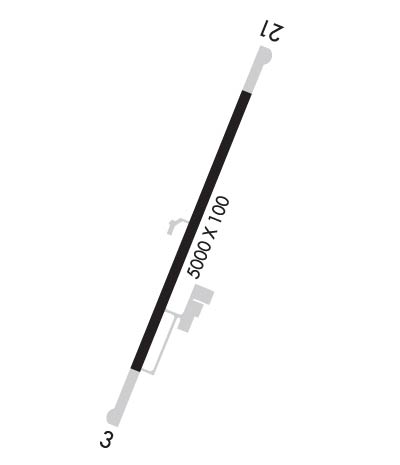
| Lat: N 3738.8 Long: W 07545.7 Elev: 48 Var: +11 Longest Runway: 5000 | ||
| AWOS: 118.17 CTAF: 122.8 | ||
| ||||||
| ||||||
|
| Rwy | Rwy | |||||||
| 5000x100 | 5000' | 110.15 - 033° | 5000x100 | 5000' | ||||
| Runway ID | Single Wheel | Double Wheel | Double Tandem Wheel | Dual Double Wheel |
| 03/21 | 26,000 | N/A | N/A | N/A |
| These numbers are Advisory and are not limits. The Airport Manager should have more accurate Weight Limits | ||||
 Airport Diagram might not be current. | |
| Facility Name: | ACCOMACK COUNTY |
| City Name: | MELFA |
| County: | ACCOMACK |
| State abbrev: | VA |
| State Name: | VIRGINIA |
| Ownership: | PUBLICLY OWNED |
| Use: | OPEN TO THE PUBLIC |
| Owner's Name: | COUNTY OF ACCOMACK |
| Address: | 29194 PARKWAY NORTH |
| MELFA, VA 23410 | |
| Owner's Phone: | 757-787-4600 |
| Manager's Name: | BRUCE HERBERT |
| Address: | 29194 PARKWAY NORTH |
| MELFA, VA 23410 | |
| Phone: | 757-787-4600 |
| FAA Region: | EASTERN |
| FAA Field Office: | DCA |

| Date | Sunrise | Sunset |
|---|---|---|
| 06/08/26 Monday | 5:41 | 20:23 |
| 06/09/26 Tuesday | 5:41 | 20:23 |
| 06/10/26 Wednesday | 5:41 | 20:24 |
| 06/11/26 Thursday | 5:41 | 20:24 |
| 06/12/26 Friday | 5:41 | 20:25 |
| 06/13/26 Saturday | 5:41 | 20:25 |
| 06/14/26 Sunday | 5:41 | 20:26 |
| 06/15/26 Monday | 5:41 | 20:26 |
| 06/16/26 Tuesday | 5:41 | 20:26 |
| 06/17/26 Wednesday | 5:41 | 20:27 |
| 06/18/26 Thursday | 5:41 | 20:27 |
| 06/19/26 Friday | 5:41 | 20:27 |
| 06/20/26 Saturday | 5:41 | 20:28 |
| 06/21/26 Sunday | 5:42 | 20:28 |
| Airport Attendance Schedule | 7 Days A Week 0830-1730; AFT HRS ACES TO RESTROOMS. |
| Airport Status | OPERATIONAL (This Status can change at any time - please check NOTAMS) |
| Airport Lighting Schedule | MIRL RWY 03/21 PRESET LOW INTST; INCR INTST & ACTVT REIL RWYS 03 & 21 - CTAF. |
| Airport Storage Available | Tie Downs |
| Extra Services Available | Crop Dusting, Charter |
| Wind Indicator | YES - (lighted) |
| Control Tower | NO |
| CTAF Frequency | 122.800 |
| Unicom Frequency | 122.800 |
| Rotating Beacon Color | WG |
| Segmented Circle | YES |
| Landing Fee | NO |
| Airport Inspected | STATE - performed by STATE AERONAUTICAL PERSONNEL |
| Inspection Date | 07/09/2025 |
| Type of Fuel Available | Grade 100LL, JET A (freeze point -40C); -10SELF-SERVE FUEL (100LL AND A) AVBL 24HRS. |
| Airframe Repair Service | NONE |
| Power Plant Repair Service | NONE |
| Latitude | N3738.8 |
| Longitude | W07545.7 (ESTIMATED) |
| Arpt Elevation | 47ft (SURVEYED) |
| Magnetic Variation | 11W |
| 1 miles W | of MELFA |
| Traffic Pattern Altitude | TPA LGT ACFT 850 FT, HVY ACFT 1500 FT. |
| Sectional Chart | WASHINGTON |
| Operations (Reported) | Yearly | Avg. Daily |
|---|---|---|
| General Aviation Transient | 0 | 0 |
| General Aviation Local | 0 | 0 |
| Air Taxi | 0 | 0 |
| Commerical | 0 | 0 |
| Commuter | 0 | 0 |
| Military | 0 | 0 |
| Aircraft based on Field | |
|---|---|
| General Aviation Singles | 0 |
| General Aviation Multi | 0 |
| Jet Aircraft | 0 |
| General Aviation Helicopters | 0 |
| Military Aircraft | 0 |
| Gliders | 0 |
| Ultralights | 0 |
| FSS on field | NO |
| FSS tie-in | LEESBURG |
| FSS Phone | 1-800-WX-BRIEF |
| Who issues Notams | MFV |
| Notam D service at airport | YES |
| ARTCC Name | WASHINGTON |
| Airport Certification | |
| Aircraft Rescue & Firefighting Index | None |
| Airport of Entry | No |
| Custom Landing Rights | No |
| Joint Civil/Military | No |
| Military Landing rights | No |
| NATIONAL PLAN OF INTEGRATED AIRPORT SYSTEMS (NPIAS) |
| OBLIGATIONS ASSUMED BY TRANSFER |
| SUBJECT TO EXCLUSIVE RIGHTS PROHIBITION OF SECTION 308A (CONSTRUCTED BY BPR). |
| DEER ON & INVOF ARPT. |
| FOR CD CTC PATUXENT APCH AT 301-342-3740, WHEN PATUXENT APCH IS CLSD CTC POTOMAC APCH AT 866-640-4124. |
Airport Communications & Frequencies:
| |||||||||||||||||||||||||
| Runway: 03 | Runway: 21 | ||
| Mag heading: | 34° | Mag heading: | 214° |
| Rwy Slope: | .02% Up | Rwy Slope: | -.02% Down |
| Approach: | LOC/DME | Approach: | |
| Pattern: | Left Traffic | Pattern: | Left Traffic |
| Markings: | NONPRECISION INSTRUMENT | Markings: | NONPRECISION INSTRUMENT |
| Marking Condition: | GOOD | Marking Condition: | GOOD |
| Arresting Dev: | Arresting Dev: | ||
| Lat & Long: | N3738.4 W07545.9 | Lat. & Long.: | N3739.2 W07545.5 |
| Elev: | 46.6 ft. MSL | Elev: | 47.6 ft. MSL |
| TCH: | 40 ft. AGL | TCH: | 40 ft. AGL |
| Visual Glide Path: | 3.00 degrees | Visual Glide Path: | 3.00 degrees |
| Displaced Threshold: | No | Displaced Threshold: | No |
| Touchdown Zone: | YES | Touchdown Zone: | YES |
| Touchdown Elev.: | 47.2 feet | Touchdown Elev.: | 47.6 feet |
| Visual Glide Slope: | 2-Light PAPI on LEFT side of Runway | Visual Glide Slope: | 2-Light PAPI on LEFT side of Runway |
| RVR Equipment: | RVR Equipment: | ||
| RVV Equipment: | NO | RVV Equipment: | NO |
| Approach Lights: | Approach Lights: | ||
| REIL: | YES | REIL: | YES |
| Centerline Lights: | NO | Centerline Lights: | NO |
| Touchdown lights: | NO | Touchdown lights: | NO |
| Runway Category: | Runway with a Non-precision Approach having visibility minimums greater than 3/4 mile | Runway Category: | Runway with a Non-precision Approach having visibility minimums greater than 3/4 mile |
| Declared Distances: | Declared Distances: | ||
| Obstructions: | TREE | Obstructions: | TREE |
| Marked: | NOT Marked/Lighted | Marked: | NOT Marked/Lighted |
| Clearance slope: | 32:1 | Clearance slope: | 16:1 |
| Obstruction height: | 74 feet AGL | Obstruction height: | 94 feet AGL |
| Dist. from runway: | 2570 feet | Dist. from runway: | 1747 feet |
| Centerline offset: | 229 left of centerline | Centerline offset: | 318 feet left of centerline |
| Comments: | Comments: |
Thanks for using FltPlan.com
all rights reserved © 1999-2026 by Flight Plan LLC