
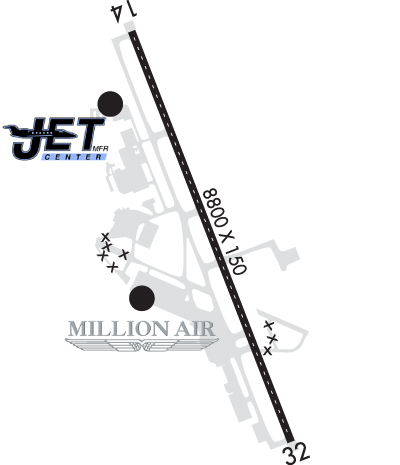
| ROGUE VALLEY INTL - MEDFORD MEDFORD OR |
| |
| Lat: N 4222.5 Long: W 12252.4 Elev: 1335 Var: -16 Longest Runway: 8800 | ||
| Dept. ATIS: 127.25 Arr. ATIS: 127.25 AWOS: 127.25 Ground: 121.8 Tower: 119.4 | ||
| |||||||||||||||||||||||||||||||||||||||||||||||||||||||||||||||||||||
| |||||||||||||||||||||||||||||||||||||||||||||||||||||||||||||||||||||
| |||||||||||||||||||||||||||||||||||||||||||||||||||||||||||||||||||||
| |||||||||||||||||||||||||||||||||||||||||||||||||||||||||||||||||||||
| Rwy | Rwy | |||||||
| 8800x150 | 8800' | 110.30 - 142° | 8800x150 | 8800' | ||||
| Runway ID | Single Wheel | Double Wheel | Double Tandem Wheel | Dual Double Wheel |
| 14/32 | 75,000 | 200,000 | 400,000 | N/A |
| These numbers are Advisory and are not limits. The Airport Manager should have more accurate Weight Limits | ||||
 Airport Diagram might not be current. | |
| Facility Name: | ROGUE VALLEY INTL - MEDFORD |
| City Name: | MEDFORD |
| County: | JACKSON |
| State abbrev: | OR |
| State Name: | OREGON |
| Ownership: | PUBLICLY OWNED |
| Use: | OPEN TO THE PUBLIC |
| Owner's Name: | JACKSON COUNTY |
| Address: | CO COURT HOUSE; 10 SO OAKDALE |
| MEDFORD, OR 97501 | |
| Owner's Phone: | 541-774-6035 |
| Manager's Name: | JERRY BRIENZA |
| Address: | 1000 TERMINAL LOOP PKWY, STE 201 |
| MEDFORD, OR 97504 | |
| Phone: | (541) 776-7222 |
| FAA Region: | NORTHWEST MOUNTAIN |
| FAA Field Office: | SEA |
| Date | Sunrise | Sunset |
|---|---|---|
| 09/24/21 Friday | 7:01 | 19:05 |
| 09/25/21 Saturday | 7:02 | 19:04 |
| 09/26/21 Sunday | 7:03 | 19:02 |
| 09/27/21 Monday | 7:04 | 19:00 |
| 09/28/21 Tuesday | 7:05 | 18:58 |
| 09/29/21 Wednesday | 7:06 | 18:57 |
| 09/30/21 Thursday | 7:07 | 18:55 |
| 10/01/21 Friday | 7:08 | 18:53 |
| 10/02/21 Saturday | 7:09 | 18:51 |
| 10/03/21 Sunday | 7:11 | 18:50 |
| 10/04/21 Monday | 7:12 | 18:48 |
| 10/05/21 Tuesday | 7:13 | 18:46 |
| 10/06/21 Wednesday | 7:14 | 18:45 |
| 10/07/21 Thursday | 7:15 | 18:43 |
| Airport Attendance Schedule | 7 Days A Week 0500-2400 |
| Airport Status | OPERATIONAL (This Status can change at any time - please check NOTAMS) |
| Airport Lighting Schedule | ACTVT MALSR RWY 14; REIL RWY 32; TDZ RWY 14; CNTRLN LGTS RWY 14/32; PAPI RWY 14 & 32; HIRL RWY 14/32; TWY LGTS - CTAF. |
| Airport Storage Available | Tie Downs, Hanger |
| Extra Services Available | Air Freight, Air Ambulance, Avionics, Cargo Handling, Flight Instruction, Aircraft Sales |
| Wind Indicator | YES - (lighted) |
| Control Tower | YES |
| CTAF Frequency | 119.400 |
| Unicom Frequency | 122.950 |
| Rotating Beacon Color | CLEAR-GREEN (Light Land Airport) |
| Segmented Circle | YES |
| Landing Fee | YES |
| Airport Inspected | FEDERAL - performed by FAA AIRPORTS FIELD PERSONNEL |
| Inspection Date | 08/23/2019 |
| Type of Fuel Available | Grade 100LL, JET A (freeze point -40C), JET A; -10FOR FUEL AFTER HOURS CALL 541-842-2254. |
| Airframe Repair Service | MAJOR |
| Power Plant Repair Service | MAJOR |
| Latitude | N4222.5 |
| Longitude | W12252.4 (ESTIMATED) |
| Arpt Elevation | 1335ft (SURVEYED) |
| Magnetic Variation | 16E |
| 3 miles N | of MEDFORD |
| Traffic Pattern Altitude | 969; 969 FT AGL FOR PROPELLER ACFT; 1469 FT AGL FOR TURBO ACFT. |
| Sectional Chart | KLAMATH FALLS |
| Operations (Reported) | Yearly | Avg. Daily |
|---|---|---|
| General Aviation Transient | 16794 | 46 |
| General Aviation Local | 5851 | 16 |
| Air Taxi | 8754 | 24 |
| Commerical | 11154 | 31 |
| Commuter | 0 | 0 |
| Military | 740 | 2 |
| Aircraft based on Field | |
|---|---|
| General Aviation Singles | 128 |
| General Aviation Multi | 27 |
| Jet Aircraft | 24 |
| General Aviation Helicopters | 13 |
| Military Aircraft | 0 |
| Gliders | 7 |
| Ultralights | 0 |
| FSS on field | NO |
| FSS tie-in | MC MINNVILLE |
| FSS Phone | 1-800-WX-BRIEF |
| Who issues Notams | MFR |
| Notam D service at airport | YES |
| ARTCC Name | SEATTLE |
| Airport Certification | AIRPORT RECEIVING SCHEDULED AIR CARRIER SERVICE FROM CARRIERS CERTIFICATED BY THE CIVIL AERONAUTICS BOARD; PPR FOR UNSKED OPNS WITH MORE THAN 30 PSGR SEATS CALL AIRPORT OPERATIONS 541-776-7228. |
| Aircraft Rescue & Firefighting Index | AIRPORT HAS A CERTIFICATE UNDER CFR PART 139 |
| Airport of Entry | No |
| Custom Landing Rights | No; US CUSTOMS USER FEE ARPT. |
| Joint Civil/Military | No |
| Military Landing rights | YES |
| NATIONAL PLAN OF INTEGRATED AIRPORT SYSTEMS (NPIAS) |
| GRANT AGREEMENTS UNDER FAAP/ADAP/AIP |
| SURPLUS PROPERTY AGREEMENT UNDER PUBLIC LAW 289 |
| ASSURANCES PURSUANT TO TITLE VI, CIVIL RIGHTS ACT OF 1964 |
| AFLD SFC CONDITION UNMONITORED BETWEEN 2400 AND 0400. |
| COLD TEMPERATURE AIRPORT. ALTITUDE CORRECTION REQUIRED AT OR BELOW -3C. |
| FOR CD IF UNA TO CTC ON FSS FREQ, CTC SEATTLE ARTCC AT 253-351-3694. |
| BIRD HAZARD LARGE FLOCKS OF MIGRATORY WATERFOWL IN VICINITY NOV-MAY. |
| TRML APRON CLSD TO ACFT EXCP SKED ACRS AND FLTS WITH PRIOR PMSN. |
| TSNT TIE-DOWNS AND HNGR AVBL THRU FBOS ONLY. |
Airport Communications & Frequencies:
| |||||||||||||||||||||||||||||
| Runway: 14 | Runway: 32 | ||
| Mag heading: | 142° | Mag heading: | 322° |
| Rwy Slope: | .47% Up | Rwy Slope: | -.47% Down |
| Approach: | ILS/DME | Approach: | |
| Pattern: | Left Traffic | Pattern: | Left Traffic |
| Markings: | PRECISION INSTRUMENT | Markings: | NONPRECISION INSTRUMENT |
| Marking Condition: | GOOD | Marking Condition: | GOOD |
| Arresting Dev: | Arresting Dev: | ||
| Lat & Long: | N4223.2 W12252.8 | Lat. & Long.: | N4221.8 W12252.0 |
| Elev: | 1294.0 ft. MSL | Elev: | 1335.3 ft. MSL |
| TCH: | 73 ft. AGL | TCH: | 50 ft. AGL |
| Visual Glide Path: | 3.00 degrees | Visual Glide Path: | 3.00 degrees |
| Displaced Threshold: | No | Displaced Threshold: | No |
| Touchdown Zone: | YES | Touchdown Zone: | YES |
| Touchdown Elev.: | 1303.2 feet | Touchdown Elev.: | 1335.3 feet |
| Visual Glide Slope: | 4-Light PAPI on LEFT side of Runway | Visual Glide Slope: | 4-Light PAPI on RIGHT side of Runway; PAPI RWY 32 DOES NOT PROVIDE OBSTRUCTION CLEARANCE BYD 6.5 NM FROM THLD. |
| RVR Equipment: | TOUCHDOWN | RVR Equipment: | ROLLOUT |
| RVV Equipment: | NO | RVV Equipment: | NO |
| Approach Lights: | MALSR - 1,400 foot medium intensity approach lighting system with runway alignment indicator lights | Approach Lights: | |
| REIL: | NO | REIL: | YES |
| Centerline Lights: | YES | Centerline Lights: | YES |
| Touchdown lights: | YES | Touchdown lights: | NO |
| Runway Category: | Precision Instrument Runway | Runway Category: | Runway with a Non-precision Approach having visibility minimums greater than 3/4 mile |
| Declared Distances: | TORA:8800' TODA:8800' ASDA:8800' LDA:8800' | Declared Distances: | TORA:8800' TODA:8800' ASDA:8800' LDA:8800' |
Thanks for using FltPlan.com
all rights reserved © 1999-2021 by Flight Plan LLC