
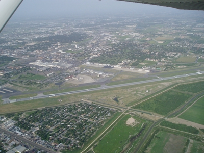
| MC ALLEN MILLER INTL MC ALLEN TX |
| |
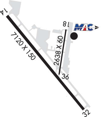
| Lat: N 2610.6 Long: W 09814.3 Elev: 107 Var: -04 Longest Runway: 7120 | ||
| Dept. ATIS: 128.5 Arr. ATIS: 128.5 Ground: 121.8 Tower: 118.5 | ||
| |||||||||||||||||||||||||||||||||||||||||||||||||||||||||||||||||||||
| |||||||||||||||||||||||||||||||||||||||||||||||||||||||||||||||||||||
| |||||||||||||||||||||||||||||||||||||||||||||||||||||||||||||||||||||
| Rwy | Rwy | |||||||
| 7120x150 | 6983' | 111.70 - 136° | 7120x150 | 7120' | 111.70 - 316° | |||
| 2639x60 | 2639' | 2639x60 | 2639' | |||||
| Runway ID | Single Wheel | Double Wheel | Double Tandem Wheel | Dual Double Wheel |
| 14/32 | 90,000 | 190,000 | 280,000 | N/A |
| 18/36 | 12,500 | N/A | N/A | N/A |
| These numbers are Advisory and are not limits. The Airport Manager should have more accurate Weight Limits | ||||
 Airport Diagram might not be current. | |
| Facility Name: | MC ALLEN INTL |
| City Name: | MC ALLEN |
| County: | HIDALGO |
| State abbrev: | TX |
| State Name: | TEXAS |
| Ownership: | PUBLICLY OWNED |
| Use: | OPEN TO THE PUBLIC |
| Owner's Name: | CITY OF MC ALLEN |
| Address: | P O BOX 220 |
| MC ALLEN, TX 78502 | |
| Owner's Phone: | 956-681-1000 |
| Manager's Name: | JEREMY SANTOSCOY |
| Address: | 2500 S BICENTENNIAL BLVD |
| MC ALLEN, TX 78503-3140 | |
| Phone: | 956-681-1500 |
| FAA Region: | SOUTHWEST |
| FAA Field Office: | TEX |
| Date | Sunrise | Sunset |
|---|---|---|
| 06/07/26 Sunday | 6:40 | 20:24 |
| 06/08/26 Monday | 6:40 | 20:24 |
| 06/09/26 Tuesday | 6:40 | 20:24 |
| 06/10/26 Wednesday | 6:40 | 20:25 |
| 06/11/26 Thursday | 6:40 | 20:25 |
| 06/12/26 Friday | 6:40 | 20:26 |
| 06/13/26 Saturday | 6:40 | 20:26 |
| 06/14/26 Sunday | 6:40 | 20:26 |
| 06/15/26 Monday | 6:40 | 20:27 |
| 06/16/26 Tuesday | 6:40 | 20:27 |
| 06/17/26 Wednesday | 6:41 | 20:27 |
| 06/18/26 Thursday | 6:41 | 20:27 |
| 06/19/26 Friday | 6:41 | 20:28 |
| 06/20/26 Saturday | 6:41 | 20:28 |
| Airport Attendance Schedule | 7 Days A Week 0600-0001; FOR SVCS AFT HRS CALL 956-686-1774. |
| Airport Status | OPERATIONAL (This Status can change at any time - please check NOTAMS) |
| Airport Lighting Schedule | WHEN ATCT CLSD ACTVT MALSR RWY 14; HIRL RWY 14/32; MIRL RWY 18/36 - CTAF. |
| Airport Storage Available | Tie Downs, Hanger |
| Extra Services Available | Air Ambulance, Avionics, Charter, Flight Instruction, Aircraft Rental, Aircraft Sales |
| Wind Indicator | YES - (lighted) |
| Control Tower | YES |
| CTAF Frequency | 118.500 |
| Unicom Frequency | 122.950 |
| Rotating Beacon Color | WG |
| Segmented Circle | YES |
| Landing Fee | NO |
| Airport Inspected | FEDERAL - performed by FAA AIRPORTS FIELD PERSONNEL |
| Inspection Date | 08/08/2025 |
| Type of Fuel Available | Grade 100LL, JET A (freeze point -40C) |
| Airframe Repair Service | MAJOR |
| Power Plant Repair Service | MAJOR |
| Latitude | N2610.6 |
| Longitude | W09814.3 (ESTIMATED) |
| Arpt Elevation | 107ft (SURVEYED) |
| Magnetic Variation | 04E |
| 2 miles S | of MC ALLEN |
| Traffic Pattern Altitude | |
| Sectional Chart | BROWNSVILLE |
| Operations (Reported) | Yearly | Avg. Daily |
|---|---|---|
| General Aviation Transient | 0 | 0 |
| General Aviation Local | 0 | 0 |
| Air Taxi | 0 | 0 |
| Commerical | 0 | 0 |
| Commuter | 0 | 0 |
| Military | 0 | 0 |
| Aircraft based on Field | |
|---|---|
| General Aviation Singles | 0 |
| General Aviation Multi | 0 |
| Jet Aircraft | 0 |
| General Aviation Helicopters | 0 |
| Military Aircraft | 0 |
| Gliders | 0 |
| Ultralights | 0 |
| FSS on field | NO |
| FSS tie-in | SAN ANGELO |
| FSS Phone | 1-800-WX-BRIEF |
| Who issues Notams | MFE |
| Notam D service at airport | YES |
| ARTCC Name | HOUSTON |
| Airport Certification | AIRPORT RECEIVING SCHEDULED AIR CARRIER SERVICE FROM CARRIERS CERTIFICATED BY THE CIVIL AERONAUTICS BOARD |
| Aircraft Rescue & Firefighting Index | AIRPORT HAS A CERTIFICATE UNDER CFR PART 139 |
| Airport of Entry | YES |
| Custom Landing Rights | No |
| Joint Civil/Military | No |
| Military Landing rights | YES |
| NATIONAL PLAN OF INTEGRATED AIRPORT SYSTEMS (NPIAS) |
| GRANT AGREEMENTS UNDER FAAP/ADAP/AIP |
| ASSURANCES PURSUANT TO TITLE VI, CIVIL RIGHTS ACT OF 1964 |
| JET OR LARGE PROPELLER ACFT TRNG PROHIBITED (INCLUDING PRACTICE APCHS; TGL & PRACTICE INSTRUMENT APCH PROCS) DUE TO NOISE ABATEMENT PROCEDURES EFFECT 2300-0600. |
| WHEN DEPARTING ARPT FLY RWY HDG UNTIL REACHING 1000 FT AGL BFR MAKING PT. |
| TWY C BTN TWY C2 AND THE APCH END OF RWY 18 NOT VSB FM ATCT. |
| FOR CD WHEN ATCT IS CLSD CTC CRP APCH AT 361-299-4230. |
| NO ACFT ENG RUN-UPS ON TRML APN. |
| FOR ARFF WHEN ATCT CLSD CTC, MC ALLEN ARPT OPNS 956-681-1500. |
| NO 180 DEGS LOCKED WHEEL TURNS ON RWY 14/32. |
| BIRDS ON & INVOF ARPT (SEASONAL). |
| RWY 18/3 6 RWY 18/36 NOT AVBL FOR PART 121/PART 380 OPS WITH SKED PAX CARRYING OPS MORE THAN 9 PAX SEATS AND NON-SKED PAX CARRYING OPS MORE THAN 30 PAX SEATS. |
| RWY 14/3 2 PCR VALUE: 880/F/A/X/T |
| RWY 18/3 6 PCR VALUE: 330/F/C/X/T |
Airport Communications & Frequencies:
| ||||||||||||||||||||||||||
| Runway: 14 | Runway: 32 | ||
| Mag heading: | 137° | Mag heading: | 317° |
| Rwy Slope: | -.09% Down | Rwy Slope: | .09% Up |
| Approach: | ILS/DME | Approach: | ILS/DME |
| Pattern: | Left Traffic | Pattern: | Left Traffic |
| Markings: | PRECISION INSTRUMENT | Markings: | PRECISION INSTRUMENT |
| Marking Condition: | FAIR | Marking Condition: | FAIR |
| Arresting Dev: | Arresting Dev: | ||
| Lat & Long: | N2611.0 W09814.8 | Lat. & Long.: | N2610.1 W09814.0 |
| Elev: | 107.2 ft. MSL | Elev: | 101.0 ft. MSL |
| TCH: | TCH: | 53 ft. AGL | |
| Visual Glide Path: | Visual Glide Path: | 3.00 degrees | |
| Displaced Threshold: | 137 feet | Displaced Threshold: | No |
| Touchdown Zone: | YES | Touchdown Zone: | YES |
| Touchdown Elev.: | 106.7 feet | Touchdown Elev.: | 101.0 feet |
| Visual Glide Slope: | Visual Glide Slope: | 2-Box VASI on LEFT side of Runway | |
| RVR Equipment: | RVR Equipment: | ||
| RVV Equipment: | NO | RVV Equipment: | NO |
| Approach Lights: | MALSR - 1,400 foot medium intensity approach lighting system with runway alignment indicator lights | Approach Lights: | |
| REIL: | NO | REIL: | YES |
| Centerline Lights: | NO | Centerline Lights: | NO |
| Touchdown lights: | NO | Touchdown lights: | NO |
| Runway Category: | Precision Instrument Runway | Runway Category: | Precision Instrument Runway |
| Declared Distances: | TORA:7120' TODA:7120' ASDA:7120' LDA:6983' | Declared Distances: | TORA:7120' TODA:7120' ASDA:7120' LDA:7120' |
| Obstructions: | ROAD | Obstructions: | |
| Marked: | NOT Marked/Lighted | Marked: | |
| Clearance slope: | 32:1; APCH RATIO 37:1 FM DSPLCD THR. | Clearance slope: | 50:1 |
| Obstruction height: | 14 feet AGL | Obstruction height: | |
| Dist. from runway: | 650 feet | Dist. from runway: | |
| Centerline offset: | 550 right of centerline | Centerline offset: | |
| Comments: | Comments: |
| Runway: 18 | Runway: 36 | ||
| Mag heading: | 185° | Mag heading: | 5° |
| Rwy Slope: | -.32% Down | Rwy Slope: | .32% Up |
| Approach: | Approach: | ||
| Pattern: | Left Traffic | Pattern: | Left Traffic |
| Markings: | BASIC | Markings: | BASIC |
| Marking Condition: | GOOD | Marking Condition: | GOOD |
| Arresting Dev: | Arresting Dev: | ||
| Lat & Long: | N2610.8 W09814.1 | Lat. & Long.: | N2610.4 W09814.2 |
| Elev: | 103.8 ft. MSL | Elev: | 95.3 ft. MSL |
| TCH: | 35 ft. AGL | TCH: | |
| Visual Glide Path: | 4.00 degrees | Visual Glide Path: | |
| Displaced Threshold: | No | Displaced Threshold: | No |
| Touchdown Zone: | YES | Touchdown Zone: | YES |
| Touchdown Elev.: | 103.8 feet | Touchdown Elev.: | 103.8 feet |
| Visual Glide Slope: | 2-Light PAPI on LEFT side of Runway; PAPI OTS INDEFLY. | Visual Glide Slope: | |
| RVR Equipment: | RVR Equipment: | ||
| RVV Equipment: | NO | RVV Equipment: | NO |
| Approach Lights: | Approach Lights: | ||
| REIL: | NO | REIL: | NO |
| Centerline Lights: | NO | Centerline Lights: | NO |
| Touchdown lights: | NO | Touchdown lights: | NO |
| Runway Category: | Runway with a Visual Approach | Runway Category: | Runway with a Visual Approach |
| Declared Distances: | TORA:2638' TODA:2638' ASDA:2638' LDA:2638' | Declared Distances: | TORA:2638' TODA:2638' ASDA:2638' LDA:2638' |
| Obstructions: | POLE | Obstructions: | |
| Marked: | NOT Marked/Lighted | Marked: | |
| Clearance slope: | 20:1 | Clearance slope: | 50:1 |
| Obstruction height: | 18 feet AGL | Obstruction height: | |
| Dist. from runway: | 575 feet | Dist. from runway: | |
| Centerline offset: | Centerline offset: | ||
| Comments: | Comments: |
Thanks for using FltPlan.com
all rights reserved © 1999-2026 by Flight Plan LLC


