
| MENA INTERMOUNTAIN MUNI MENA AR |
| |
| Lat: N 3432.7 Long: W 09412.1 Elev: 1080 Var: -03 Longest Runway: 5485 | ||
| AWOS: 118.02 CTAF: 122.8 | ||
| ||||||||||||||||||||||||||||||||||||||||||||
| ||||||||||||||||||||||||||||||||||||||||||||
| ||||||||||||||||||||||||||||||||||||||||||||
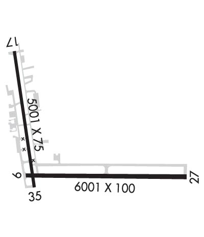
| Rwy | Rwy | |||||||
| 5485x100 | 5485' | 5485x100 | 5485' | 108.70 - 269° | ||||
| 5001x75 | 5001' | 5001x75 | 5001' | |||||
| Runway ID | Single Wheel | Double Wheel | Double Tandem Wheel | Dual Double Wheel |
| 09/27 | 75,000 | 200,000 | 300,000 | N/A |
| 17/35 | 75,000 | 100,000 | 160,000 | N/A |
| These numbers are Advisory and are not limits. The Airport Manager should have more accurate Weight Limits | ||||
 Airport Diagram might not be current. | |
| Facility Name: | MENA INTERMOUNTAIN MUNI |
| City Name: | MENA |
| County: | POLK |
| State abbrev: | AR |
| State Name: | ARKANSAS |
| Ownership: | PUBLICLY OWNED |
| Use: | OPEN TO THE PUBLIC |
| Owner's Name: | CITY OF MENA |
| Address: | 520 MENA ST |
| MENA, AR 71953 | |
| Owner's Phone: | 479-394-5800; AFTER HOURS PLEASE CALL 479-394-4077 |
| Manager's Name: | FRED OGDEN |
| Address: | 520 MENA ST |
| MENA, AR 71953 | |
| Phone: | 479-394-4077 |
| FAA Region: | SOUTHWEST |
| FAA Field Office: | AOK |
| Date | Sunrise | Sunset |
|---|---|---|
| 06/08/26 Monday | 6:04 | 20:28 |
| 06/09/26 Tuesday | 6:04 | 20:29 |
| 06/10/26 Wednesday | 6:04 | 20:29 |
| 06/11/26 Thursday | 6:03 | 20:29 |
| 06/12/26 Friday | 6:03 | 20:30 |
| 06/13/26 Saturday | 6:03 | 20:30 |
| 06/14/26 Sunday | 6:03 | 20:31 |
| 06/15/26 Monday | 6:04 | 20:31 |
| 06/16/26 Tuesday | 6:04 | 20:31 |
| 06/17/26 Wednesday | 6:04 | 20:32 |
| 06/18/26 Thursday | 6:04 | 20:32 |
| 06/19/26 Friday | 6:04 | 20:32 |
| 06/20/26 Saturday | 6:04 | 20:32 |
| 06/21/26 Sunday | 6:04 | 20:33 |
| Airport Attendance Schedule | 7 Days A Week DAWN-DUSK |
| Airport Status | OPERATIONAL (This Status can change at any time - please check NOTAMS) |
| Airport Lighting Schedule | MIRL RWY 09/27 OPR SS-SR. ACTVT PAPI RWYS 09, 27, & 17; MIRL RWY 17/35 - CTAF. |
| Airport Storage Available | Tie Downs, Hanger |
| Extra Services Available | Flight Instruction, Aircraft Rental, Aircraft Sales |
| Wind Indicator | YES - (lighted) |
| Control Tower | NO |
| CTAF Frequency | 122.800 |
| Unicom Frequency | 122.800 |
| Rotating Beacon Color | WG |
| Segmented Circle | YES |
| Landing Fee | NO |
| Airport Inspected | STATE - performed by STATE AERONAUTICAL PERSONNEL |
| Inspection Date | 08/31/2022 |
| Type of Fuel Available | Grade 100LL, JET A (freeze point -40C) |
| Airframe Repair Service | MAJOR |
| Power Plant Repair Service | MAJOR |
| Latitude | N3432.7 |
| Longitude | W09412.1 (ESTIMATED) |
| Arpt Elevation | 1079ft (ESTIMATED) |
| Magnetic Variation | 03E |
| 2 miles SE | of MENA |
| Traffic Pattern Altitude | |
| Sectional Chart | MEMPHIS |
| Operations (Reported) | Yearly | Avg. Daily |
|---|---|---|
| General Aviation Transient | 0 | 0 |
| General Aviation Local | 0 | 0 |
| Air Taxi | 0 | 0 |
| Commerical | 0 | 0 |
| Commuter | 0 | 0 |
| Military | 0 | 0 |
| Aircraft based on Field | |
|---|---|
| General Aviation Singles | 0 |
| General Aviation Multi | 0 |
| Jet Aircraft | 0 |
| General Aviation Helicopters | 0 |
| Military Aircraft | 0 |
| Gliders | 0 |
| Ultralights | 0 |
| FSS on field | NO |
| FSS tie-in | JONESBORO |
| FSS Phone | 1-800-WX-BRIEF |
| Who issues Notams | MEZ |
| Notam D service at airport | YES |
| ARTCC Name | MEMPHIS |
| Airport Certification | |
| Aircraft Rescue & Firefighting Index | None |
| Airport of Entry | No |
| Custom Landing Rights | No |
| Joint Civil/Military | No |
| Military Landing rights | YES |
| NATIONAL PLAN OF INTEGRATED AIRPORT SYSTEMS (NPIAS) |
| GRANT AGREEMENTS UNDER FAAP/ADAP/AIP |
| ASSURANCES PURSUANT TO TITLE VI, CIVIL RIGHTS ACT OF 1964 |
| MOUNTAINS NORTH AND SOUTH SOUTHWEST OF ARPT. |
| MIGRATORY BIRDS & DEER ON & INVOF ARPT. |
| FOR CD CTC MEMPHIS ARTCC AT 901-368-8453/8449. |
Airport Communications & Frequencies:
| |||||||||
| Runway: 09 | Runway: 27 | ||
| Mag heading: | 89° | Mag heading: | 269° |
| Rwy Slope: | -.45% Down | Rwy Slope: | .45% Up |
| Approach: | Approach: | ILS/DME | |
| Pattern: | Left Traffic | Pattern: | Left Traffic |
| Markings: | NONPRECISION INSTRUMENT | Markings: | NONPRECISION INSTRUMENT |
| Marking Condition: | GOOD | Marking Condition: | GOOD |
| Arresting Dev: | Arresting Dev: | ||
| Lat & Long: | N3432.6 W09412.4 | Lat. & Long.: | N3432.5 W09411.3 |
| Elev: | 1074.9 ft. MSL | Elev: | 1050.1 ft. MSL |
| TCH: | 44 ft. AGL | TCH: | 49 ft. AGL |
| Visual Glide Path: | 3.50 degrees | Visual Glide Path: | 3.00 degrees |
| Displaced Threshold: | No | Displaced Threshold: | No |
| Touchdown Zone: | YES | Touchdown Zone: | YES |
| Touchdown Elev.: | 1077.7 feet | Touchdown Elev.: | 1063.5 feet |
| Visual Glide Slope: | 4-Light PAPI on LEFT side of Runway; PAPI RWY 9 UNUSBL BYD 7 DEG RIGHT OF CNTRLN. | Visual Glide Slope: | 4-Light PAPI on LEFT side of Runway |
| RVR Equipment: | RVR Equipment: | ||
| RVV Equipment: | NO | RVV Equipment: | NO |
| Approach Lights: | Approach Lights: | ||
| REIL: | YES | REIL: | YES |
| Centerline Lights: | NO | Centerline Lights: | NO |
| Touchdown lights: | NO | Touchdown lights: | NO |
| Runway Category: | Runway with a Non-precision Approach having visibility minimums greater than 3/4 mile | Runway Category: | Precision Instrument Runway |
| Declared Distances: | Declared Distances: | ||
| Obstructions: | 1675 FT MT 13000 FT WEST OF RWY THR. | Obstructions: | |
| Marked: | NOT Marked/Lighted | Marked: | |
| Clearance slope: | 50:1 | Clearance slope: | 50:1 |
| Obstruction height: | Obstruction height: | ||
| Dist. from runway: | Dist. from runway: | ||
| Centerline offset: | Centerline offset: | ||
| Comments: | Comments: |
| Runway: 17 | Runway: 35 | ||
| Mag heading: | 170° | Mag heading: | 350° |
| Rwy Slope: | .78% Up | Rwy Slope: | -.78% Down |
| Approach: | Approach: | ||
| Pattern: | Left Traffic | Pattern: | Left Traffic |
| Markings: | NONPRECISION INSTRUMENT | Markings: | NONPRECISION INSTRUMENT |
| Marking Condition: | GOOD | Marking Condition: | GOOD |
| Arresting Dev: | Arresting Dev: | ||
| Lat & Long: | N3433.3 W09412.5 | Lat. & Long.: | N3432.5 W09412.4 |
| Elev: | 1040.7 ft. MSL | Elev: | 1079.9 ft. MSL |
| TCH: | 53 ft. AGL | TCH: | |
| Visual Glide Path: | 3.00 degrees | Visual Glide Path: | |
| Displaced Threshold: | No | Displaced Threshold: | No |
| Touchdown Zone: | YES | Touchdown Zone: | YES |
| Touchdown Elev.: | 1063.4 feet | Touchdown Elev.: | 1079.9 feet |
| Visual Glide Slope: | 4-Light PAPI on LEFT side of Runway | Visual Glide Slope: | |
| RVR Equipment: | RVR Equipment: | ||
| RVV Equipment: | NO | RVV Equipment: | NO |
| Approach Lights: | Approach Lights: | ||
| REIL: | NO | REIL: | YES |
| Centerline Lights: | NO | Centerline Lights: | NO |
| Touchdown lights: | NO | Touchdown lights: | NO |
| Runway Category: | Runway with a Non-precision Approach having visibility minimums greater than 3/4 mile | Runway Category: | Runway with a Visual Approach |
| Declared Distances: | Declared Distances: | ||
| Obstructions: | TREE | Obstructions: | TREE |
| Marked: | NOT Marked/Lighted | Marked: | NOT Marked/Lighted |
| Clearance slope: | 30:1 | Clearance slope: | 25:1 |
| Obstruction height: | 20 feet AGL | Obstruction height: | 40 feet AGL |
| Dist. from runway: | 800 feet | Dist. from runway: | 1200 feet |
| Centerline offset: | 55 right of centerline | Centerline offset: | 450 feet right of centerline |
| Comments: | Comments: |
Thanks for using FltPlan.com
all rights reserved © 1999-2026 by Flight Plan LLC