
| CASTLE ATWATER CA |
| |
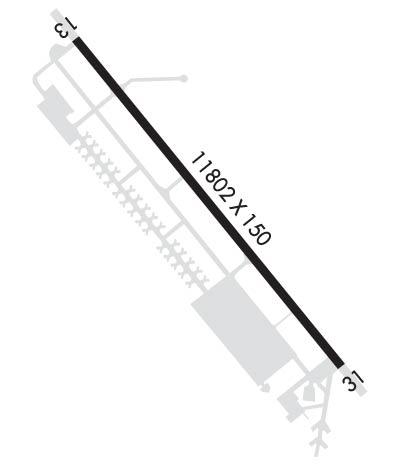
| Lat: N 3722.8 Long: W 12034.1 Elev: 190 Var: -15 Longest Runway: 11802 | ||
| Dept. ATIS: 124.47 Arr. ATIS: 124.47 AWOS: 124.47 Ground: 133.57 Tower: 118.17 | ||
| ||||||
| ||||||
|
| Rwy | Rwy | |||||||
| 11802x150 | 11802' | 11802x150 | 11802' | 109.50 - 306° | ||||
| Runway ID | Single Wheel | Double Wheel | Double Tandem Wheel | Dual Double Wheel |
| 13/31 | 155,000 | 200,000 | 415,000 | 720,000 |
| These numbers are Advisory and are not limits. The Airport Manager should have more accurate Weight Limits | ||||
 Airport Diagram might not be current. | |
| Facility Name: | CASTLE |
| City Name: | ATWATER |
| County: | MERCED |
| State abbrev: | CA |
| State Name: | CALIFORNIA |
| Ownership: | PUBLICLY OWNED |
| Use: | OPEN TO THE PUBLIC |
| Owner's Name: | MERCED COUNTY; COMMUNITY & ECONOMIC DEVELOPMENT |
| Address: | 2222 M STREET |
| MERCED, CA 95340 | |
| Owner's Phone: | 209-385-7686 |
| Manager's Name: | GEORGE CLOVER |
| Address: | 2222 M STREET; MAILING ADDRESS |
| MERCED, CA 95340-4180 | |
| Phone: | 209-617-5399; DESK PHONE 209-385-7686, EXTN 4180. |
| FAA Region: | WESTERN-PACIFIC |
| FAA Field Office: | SFO |
| Date | Sunrise | Sunset |
|---|---|---|
| 06/07/26 Sunday | 5:41 | 20:21 |
| 06/08/26 Monday | 5:41 | 20:21 |
| 06/09/26 Tuesday | 5:41 | 20:22 |
| 06/10/26 Wednesday | 5:41 | 20:22 |
| 06/11/26 Thursday | 5:41 | 20:23 |
| 06/12/26 Friday | 5:41 | 20:23 |
| 06/13/26 Saturday | 5:41 | 20:24 |
| 06/14/26 Sunday | 5:41 | 20:24 |
| 06/15/26 Monday | 5:41 | 20:25 |
| 06/16/26 Tuesday | 5:41 | 20:25 |
| 06/17/26 Wednesday | 5:41 | 20:25 |
| 06/18/26 Thursday | 5:41 | 20:26 |
| 06/19/26 Friday | 5:41 | 20:26 |
| 06/20/26 Saturday | 5:42 | 20:26 |
| Airport Attendance Schedule | MON-FRI 0800-1700 |
| Airport Status | OPERATIONAL (This Status can change at any time - please check NOTAMS) |
| Airport Lighting Schedule | WHEN ATCT CLSD ACTVT ALSF1 RWYS 13 & 31; HIRL RWY 13/31 - CTAF; 3 CLICKS ON, 5 CLICKS INCR INTST, 7 CLICKS OFF. PAPI RWYS 13 & 31 OPR CONSLY. |
| Airport Storage Available | Tie Downs, Hanger |
| Extra Services Available | NONE |
| Wind Indicator | YES - (lighted) |
| Control Tower | YES |
| CTAF Frequency | 118.175 |
| Unicom Frequency | 122.950 |
| Rotating Beacon Color | WG |
| Segmented Circle | YES |
| Landing Fee | NO |
| Airport Inspected | STATE - performed by STATE AERONAUTICAL PERSONNEL |
| Inspection Date | 01/27/2025 |
| Type of Fuel Available | Grade 100LL, JET A (freeze point -40C), JET A-1 (freeze point -50C); -10FOR FUEL FM 1800-0900 CALL (209) 725-1455. |
| Airframe Repair Service | MINOR |
| Power Plant Repair Service | MINOR |
| Latitude | N3722.8 |
| Longitude | W12034.1 (ESTIMATED) |
| Arpt Elevation | 190ft (SURVEYED) |
| Magnetic Variation | 15E |
| 3 miles NE | of ATWATER |
| Traffic Pattern Altitude | |
| Sectional Chart | SAN FRANCISCO |
| Operations (Reported) | Yearly | Avg. Daily |
|---|---|---|
| General Aviation Transient | 0 | 0 |
| General Aviation Local | 0 | 0 |
| Air Taxi | 0 | 0 |
| Commerical | 0 | 0 |
| Commuter | 0 | 0 |
| Military | 0 | 0 |
| Aircraft based on Field | |
|---|---|
| General Aviation Singles | 0 |
| General Aviation Multi | 0 |
| Jet Aircraft | 0 |
| General Aviation Helicopters | 0 |
| Military Aircraft | 0 |
| Gliders | 0 |
| Ultralights | 0 |
| FSS on field | NO |
| FSS tie-in | RANCHO MURIETA |
| FSS Phone | 1-800-WX-BRIEF |
| Who issues Notams | MER |
| Notam D service at airport | YES |
| ARTCC Name | OAKLAND |
| Airport Certification | |
| Aircraft Rescue & Firefighting Index | None |
| Airport of Entry | No |
| Custom Landing Rights | No |
| Joint Civil/Military | No |
| Military Landing rights | YES |
| NATIONAL PLAN OF INTEGRATED AIRPORT SYSTEMS (NPIAS) |
| WHEN ATCT CLSD MAX OF 5 ACFT PMTD IN VFR TFC PAT AT ANY ONE TIME AND 2000 FT CIG AND 3 MIS VIS RCMDD. |
| FOR CD WHEN ATCT IS CLSD CTC NORCAL APCH AT 916-361-0516. |
| TWY B CLSD TO ACFT GTR THAN 30000 LBS. |
| RY 13/31 180 DEGREE TURNS PROHIBITIED. |
| FOR ARPT INFO 209-385-7686, EXTN 4180. |
| RY 31 WILL BE THE DESIGNATED CALM WIND RY (WIND 5 KNOTS OR LESS). |
| OPPOSITE END OF RY NOT VISIBLE ON TKOF. WHEN ATCT CLSD OPPOSITE DIRECTION TAKEOFFS AND LANDINGS ARE NOT AUTHORIZED. |
| CIVILIAN AND MILITARY TRAINING MAY OCCASIONALLY CAUSE PATTERN CONGESTION. |
| RWY 13/3 1 1,000 FT PAVED BLAST PAD BOTH ENDS OF RY. |
Airport Communications & Frequencies:
| |||||||||||||||||||||||||
| Runway: 13 | Runway: 31 | ||
| Mag heading: | 126° | Mag heading: | 306° |
| Rwy Slope: | -.11% Down | Rwy Slope: | .11% Up |
| Approach: | Approach: | LOC/GS | |
| Pattern: | Left Traffic | Pattern: | Right Traffic |
| Markings: | NONPRECISION INSTRUMENT | Markings: | PRECISION INSTRUMENT |
| Marking Condition: | GOOD | Marking Condition: | GOOD |
| Arresting Dev: | Arresting Dev: | ||
| Lat & Long: | N3723.6 W12034.9 | Lat. & Long.: | N3722.1 W12033.3 |
| Elev: | 190.4 ft. MSL | Elev: | 177.7 ft. MSL |
| TCH: | 75 ft. AGL | TCH: | 71 ft. AGL |
| Visual Glide Path: | 3.00 degrees | Visual Glide Path: | 3.00 degrees |
| Displaced Threshold: | No | Displaced Threshold: | No |
| Touchdown Zone: | YES | Touchdown Zone: | YES |
| Touchdown Elev.: | 190.4 feet | Touchdown Elev.: | 180.7 feet |
| Visual Glide Slope: | 4-Light PAPI on LEFT side of Runway | Visual Glide Slope: | 4-Light PAPI on LEFT side of Runway |
| RVR Equipment: | RVR Equipment: | ||
| RVV Equipment: | NO | RVV Equipment: | NO |
| Approach Lights: | ALSF1 - standard 2,400 foot high intensity approach lighting system with sequenced flashers, Category I | Approach Lights: | ALSF1 - standard 2,400 foot high intensity approach lighting system with sequenced flashers, Category I; ALSF1 RY 13/31 SEQUENCED FLASHING LGTS OTS INDEFLY. |
| REIL: | NO | REIL: | NO |
| Centerline Lights: | NO | Centerline Lights: | NO |
| Touchdown lights: | NO | Touchdown lights: | NO |
| Runway Category: | D | Runway Category: | Precision Instrument Runway |
| Declared Distances: | Declared Distances: |
Thanks for using FltPlan.com
all rights reserved © 1999-2026 by Flight Plan LLC
