| MEMPHIS INTL MEMPHIS TN |
| |
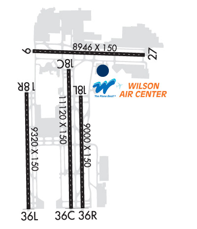
| Lat: N 3502.5 Long: W 08958.6 Elev: 341 Var: +01 Longest Runway: 11120 | ||
| Clr Del: 125.2 Dept. ATIS: 127.75 Arr. ATIS: 127.75 Ground: 121.65/121.9 Tower: NS119.7/118.3 | ||
| |||||||||||||||||||||||||||||||||||||||||||||||||||||||||||||||||||||
| |||||||||||||||||||||||||||||||||||||||||||||||||||||||||||||||||||||
| |||||||||||||||||||||||||||||||||||||||||||||||||||||||||||||||||||||
| |||||||||||||||||||||||||||||||||||||||||||||||||||||||||||||||||||||
| Rwy | Rwy | |||||||
| 8946x150 | 8946' | 109.50 - 092° | 8946x150 | 8946' | 108.70 - 272° | |||
| 11120x150 | 11120' | 111.95 - 180° | 11120x150 | 11120' | 110.50 - 000° | |||
| 9000x150 | 9000' | 111.15 - 180° | 9000x150 | 9000' | 111.35 - 360° | |||
| 9320x150 | 9320' | 109.90 - 179° | 9320x150 | 9320' | 108.90 - 359° | |||
| Runway ID | Single Wheel | Double Wheel | Double Tandem Wheel | Dual Double Wheel |
| 09/27 | 120,000 | 250,000 | 550,000 | 1,120,000 |
| 18C/36C | 120,000 | 250,000 | 550,000 | 1,120,000 |
| 18L/36R | 120,000 | 250,000 | 550,000 | 1,120,000 |
| 18R/36L | 120,000 | 250,000 | 550,000 | 1,120,000 |
| These numbers are Advisory and are not limits. The Airport Manager should have more accurate Weight Limits | ||||
 Airport Diagram might not be current. | |
| Facility Name: | FREDERICK W SMITH INTL/MEMPHIS |
| City Name: | MEMPHIS |
| County: | SHELBY |
| State abbrev: | TN |
| State Name: | TENNESSEE |
| Ownership: | PUBLICLY OWNED |
| Use: | OPEN TO THE PUBLIC |
| Owner's Name: | MEMPHIS SHELBY CNTY ARPT AUTH |
| Address: | 2491 WINCHESTER RD. |
| MEMPHIS, TN 38116-3856 | |
| Owner's Phone: | 901-922-8000 |
| Manager's Name: | TERRY BLUE |
| Address: | 2491 WINCHESTER RD., SUITE 113 |
| MEMPHIS, TN 38116-3856 | |
| Phone: | 901-922-8000 |
| FAA Region: | SOUTHERN |
| FAA Field Office: | MEM |
| Date | Sunrise | Sunset |
|---|---|---|
| 06/08/26 Monday | 5:46 | 20:12 |
| 06/09/26 Tuesday | 5:45 | 20:13 |
| 06/10/26 Wednesday | 5:45 | 20:13 |
| 06/11/26 Thursday | 5:45 | 20:14 |
| 06/12/26 Friday | 5:45 | 20:14 |
| 06/13/26 Saturday | 5:45 | 20:15 |
| 06/14/26 Sunday | 5:45 | 20:15 |
| 06/15/26 Monday | 5:45 | 20:15 |
| 06/16/26 Tuesday | 5:45 | 20:16 |
| 06/17/26 Wednesday | 5:45 | 20:16 |
| 06/18/26 Thursday | 5:46 | 20:16 |
| 06/19/26 Friday | 5:46 | 20:17 |
| 06/20/26 Saturday | 5:46 | 20:17 |
| 06/21/26 Sunday | 5:46 | 20:17 |
| Airport Attendance Schedule | CONTINUOUS |
| Airport Status | OPERATIONAL (This Status can change at any time - please check NOTAMS) |
| Airport Lighting Schedule | SS-SR |
| Airport Storage Available | Tie Downs, Hanger |
| Extra Services Available | Air Freight, Avionics, Cargo Handling, Charter, Aircraft Rental, Aircraft Sales |
| Wind Indicator | YES - (lighted) |
| Control Tower | YES |
| CTAF Frequency | |
| Unicom Frequency | 122.950 |
| Rotating Beacon Color | WG |
| Segmented Circle | NO |
| Landing Fee | NO |
| Airport Inspected | FEDERAL - performed by STATE AERONAUTICAL PERSONNEL |
| Inspection Date | 08/29/2024 |
| Type of Fuel Available | Grade 100LL, JET A (freeze point -40C), JET AA++ |
| Airframe Repair Service | MAJOR |
| Power Plant Repair Service | MAJOR |
| Latitude | N3502.5 |
| Longitude | W08958.6 (ESTIMATED) |
| Arpt Elevation | 340ft (SURVEYED) |
| Magnetic Variation | 01W |
| 3 miles S | of MEMPHIS |
| Traffic Pattern Altitude | |
| Sectional Chart | MEMPHIS |
| Operations (Reported) | Yearly | Avg. Daily |
|---|---|---|
| General Aviation Transient | 0 | 0 |
| General Aviation Local | 0 | 0 |
| Air Taxi | 0 | 0 |
| Commerical | 0 | 0 |
| Commuter | 0 | 0 |
| Military | 0 | 0 |
| Aircraft based on Field | |
|---|---|
| General Aviation Singles | 0 |
| General Aviation Multi | 0 |
| Jet Aircraft | 0 |
| General Aviation Helicopters | 0 |
| Military Aircraft | 0 |
| Gliders | 0 |
| Ultralights | 0 |
| FSS on field | NO |
| FSS tie-in | JACKSON |
| FSS Phone | 1-800-WX-BRIEF |
| Who issues Notams | MEM |
| Notam D service at airport | YES |
| ARTCC Name | MEMPHIS |
| Airport Certification | AIRPORT RECEIVING SCHEDULED AIR CARRIER SERVICE FROM CARRIERS CERTIFICATED BY THE CIVIL AERONAUTICS BOARD; INDEX D ARFF EQUIP H24. |
| Aircraft Rescue & Firefighting Index | AIRPORT HAS A CERTIFICATE UNDER CFR PART 139 |
| Airport of Entry | No |
| Custom Landing Rights | YES |
| Joint Civil/Military | No |
| Military Landing rights | YES |
| NATIONAL PLAN OF INTEGRATED AIRPORT SYSTEMS (NPIAS) |
| GRANT AGREEMENTS UNDER FAAP/ADAP/AIP |
| SURPLUS PROPERTY AGREEMENT UNDER PUBLIC LAW 289 |
| ASSURANCES PURSUANT TO TITLE VI, CIVIL RIGHTS ACT OF 1964 |
| AGREEMENT UNDER DLAND OR DCLA HAS EXPIRED. |
| TWY N NORTH OF TWY V, TWY C NORTH OF TWY V, TWY S NORTH OF TWY V AND TWY V WEST OF TWY N DESIGNATED AS NON-MOVEMENT AREAS. |
| LRG & HVY EBND ACFT ON TWY V FOR RWY 27 HOLD SHORT AT MNM THRUST AREA SIGN. |
| PPR FOR TAXI CLNC ON TWY N NORTH OF TWY V, TWY S NORTH TWY V & TWY C NORTH OF TWY V - FEDEX RAMP ATCT 131.5. |
| TWY V BTN SPOT 7W & RWY 27 RSTR TO ACFT WITH WINGSPAN OF 171 FT 6 IN OR LESS. |
| TWY V BTN TWY S & Y RSTR TO ACFT WITH TAIL HEIGHT 65 FT 10 IN OR LESS. |
| ANG-PPR DSN 726-7131/7505, C901-291-7131/7505. MIL RAMP OPS 1400-0400Z++ MON-FRI; CLSD ALTN MON & HOL. MIL RAMP CLSD OUTSIDE OF PUB HR WITHOUT OG/CC APVL DSN 726-7557, C901-291-7557. TSNT ACFT MAINT NOT AVBL. REFUEL SVC FOR OTR THAN C17 ACFT RQR QUALIFIED CREW CHIEF OR CREWMEMBERS. NON-C17 ACFT SUPPORT PRVDD BY CONTRACT FBO ON FLD. SECURITY AVBL 24 HRS, DSN 726-7101, C901-291-7101. COMD POST DSN 726-7148/7311/7312, C901-291-7148/7311/7312. OPR 1230-0430Z++ MON-FRI, CLSD ALTN MON AND HOL DUE TO ALTN WORK SCHED. AFLD MGR DOES NOT ISSUE OR STORE COMSEC FOR TRAN CRES. TMPRY STOR OF CLASSIFIED MATERIALS UP TO TOP SECRET AT COMD POST. |
| CTC RAMP CONTROL 121.8 FOR ENTRY ON ANG RAMP. ANG FREQS 138.95 353.45. AFT HR CTC COMMAND POST - DSN 726-7148; C901-291-7311/7312 OR SECURITY FORCES - DSN 726-7101; C901-291-7101/7133. |
| HOLD SHORT INSTRN READ BACK RQR. |
| BASH PHASE II APR-MAY & AUG-OCT; CURRENT BIRD WATCH COND NOT ON ATIS. |
| ANG RAMP OFFL BUS ONLY; PPR - V966-8131. TSNT ACFT RQR FOLLOW ME ASSIST ENTERING ANG RAMP. |
| PPR FOR TAXI CLNC FM N & S CARGO RAMP PRKG - 121.9. |
| COMMUNICATIONS-ANG COMD POST: RADIO CALL GRACELAND OPS. |
| NOISE ABATEMENT PROC IN EFCT. SUCCESSIVE AND/OR SIMUL DEP APVD ON RWY 36L-18R & RWY 36C-18C OR RWY 36L-18R & RWY 36R-18L WITH COURSE DVRGNC NO LATER THAN 2.27 NM FROM RWY END. |
| ANG: PPR 24 HR PN RQR; OFFL BUS ONLY. |
| AIRCRAFT WITH WINGSPANS GREATER THAN 118 FEET RESTRICTED FROM TAXIING ON TWY J NORTH OF TWY U. |
| ANG-ATIS INFO RPRTS BIRD ACT H24. |
| HELI OPS TO/FM TRML BLDG NA. |
| MIL: MIL RAMP OPS AT REDUCED ARFF, DOWNGRADED TO YELLOW. |
| TWY N BTN TWY M & TWY M7 CLSD TO WINGSPAN MORE THAN 171.5 FT EXC TAX SPEED LESS THAN 15 MPH. |
| MEM AD AP ALL SAFETY AREA NOT STD GRADING. |
| MIL: ANG - HAZ1.1 & 1.2 NOT ALLOWED ON MSCAA OR TANG. |
| BIRDS INVOF ARPT. |
| RWY 18R/ 36LA-GEAR: ENGRD MTRL EMAS 316 FT LEN 178 FT WID DEP END RWY 18R. |
| RWY 18C/ 36CSINGLE BELLY TWIN TANDEM LNDG GEAR - 621. |
| RWY 18L/ 36RSINGLE BELLY TWIN TANDEM LNDG GEAR - 621. |
| RWY 18R/ 36LSINGLE BELLY TWIN TANDEM LNDG GEAR - 621. |
| RWY 09/2 7 PCR VALUE: 1253/R/C/W/T |
| RWY 18C/ 36CPCR VALUE: 1253/R/C/W/T |
| RWY 18L/ 36RPCR VALUE: 1207/R/C/W/T |
| RWY 18R/ 36LPCR VALUE: 1253/R/C/W/T |
Airport Communications & Frequencies:
| |||||||||||||||||||||||||||||||||||||||||||||||||||||||||||||
| Runway: 09 | Runway: 27 | ||
| Mag heading: | 93° | Mag heading: | 273° |
| Rwy Slope: | .43% Up | Rwy Slope: | -.43% Down |
| Approach: | ILS | Approach: | ILS |
| Pattern: | Left Traffic | Pattern: | Left Traffic |
| Markings: | PRECISION INSTRUMENT | Markings: | PRECISION INSTRUMENT |
| Marking Condition: | GOOD | Marking Condition: | GOOD |
| Arresting Dev: | Arresting Dev: | ||
| Lat & Long: | N3503.5 W08959.1 | Lat. & Long.: | N3503.5 W08957.4 |
| Elev: | 253.2 ft. MSL | Elev: | 292.0 ft. MSL |
| TCH: | TCH: | 69 ft. AGL | |
| Visual Glide Path: | Visual Glide Path: | 3.00 degrees | |
| Displaced Threshold: | No | Displaced Threshold: | No |
| Touchdown Zone: | YES | Touchdown Zone: | YES |
| Touchdown Elev.: | 258.7 feet | Touchdown Elev.: | 292.0 feet |
| Visual Glide Slope: | Visual Glide Slope: | 4-Light PAPI on LEFT side of Runway | |
| RVR Equipment: | TOUCHDOWN-ROLLOUT | RVR Equipment: | TOUCHDOWN-ROLLOUT |
| RVV Equipment: | NO | RVV Equipment: | NO |
| Approach Lights: | MALSR - 1,400 foot medium intensity approach lighting system with runway alignment indicator lights | Approach Lights: | MALSR - 1,400 foot medium intensity approach lighting system with runway alignment indicator lights |
| REIL: | NO | REIL: | NO |
| Centerline Lights: | YES | Centerline Lights: | YES |
| Touchdown lights: | NO | Touchdown lights: | NO |
| Runway Category: | Precision Instrument Runway | Runway Category: | Precision Instrument Runway |
| Declared Distances: | TORA:8946' TODA:8946' ASDA:8946' LDA:8946' | Declared Distances: | TORA:8946' TODA:8946' ASDA:8946' LDA:8946' |
| Obstructions: | POLE | Obstructions: | POLE |
| Marked: | NOT Marked/Lighted | Marked: | NOT Marked/Lighted |
| Clearance slope: | 38:1 | Clearance slope: | 30:1 |
| Obstruction height: | 27 feet AGL | Obstruction height: | 50 feet AGL |
| Dist. from runway: | 1243 feet | Dist. from runway: | 1707 feet |
| Centerline offset: | 607 left of centerline | Centerline offset: | 662 feet right of centerline |
| Comments: | Comments: |
| Runway: 18C | Runway: 36C | ||
| Mag heading: | 180° | Mag heading: | 360° |
| Rwy Slope: | .63% Up | Rwy Slope: | -.63% Down |
| Approach: | ILS | Approach: | ILS/DME |
| Pattern: | Left Traffic | Pattern: | Right Traffic |
| Markings: | PRECISION INSTRUMENT | Markings: | PRECISION INSTRUMENT |
| Marking Condition: | GOOD | Marking Condition: | GOOD |
| Arresting Dev: | Arresting Dev: | ||
| Lat & Long: | N3503.3 W08958.6 | Lat. & Long.: | N3501.4 W08958.5 |
| Elev: | 270.6 ft. MSL | Elev: | 340.9 ft. MSL |
| TCH: | TCH: | 71 ft. AGL | |
| Visual Glide Path: | Visual Glide Path: | 3.00 degrees | |
| Displaced Threshold: | No | Displaced Threshold: | No |
| Touchdown Zone: | YES | Touchdown Zone: | YES |
| Touchdown Elev.: | 290.1 feet | Touchdown Elev.: | 340.9 feet |
| Visual Glide Slope: | Visual Glide Slope: | 4-Light PAPI on LEFT side of Runway | |
| RVR Equipment: | TOUCHDOWN-MIDFIELD-ROLLOUT | RVR Equipment: | TOUCHDOWN-MIDFIELD-ROLLOUT |
| RVV Equipment: | NO | RVV Equipment: | NO |
| Approach Lights: | MALSR - 1,400 foot medium intensity approach lighting system with runway alignment indicator lights | Approach Lights: | ALSF2 - standard 2,400 foot high intensity approach lighting system with sequenced flashers, Category II or III |
| REIL: | NO | REIL: | NO |
| Centerline Lights: | YES | Centerline Lights: | YES |
| Touchdown lights: | YES | Touchdown lights: | YES |
| Runway Category: | Precision Instrument Runway | Runway Category: | Precision Instrument Runway |
| Declared Distances: | TORA:11120' TODA:11120' ASDA:11120' LDA:11120' | Declared Distances: | TORA:11120' TODA:11120' ASDA:10715' LDA:10715' |
| Obstructions: | POLE | Obstructions: | TREE |
| Marked: | NOT Marked/Lighted | Marked: | NOT Marked/Lighted |
| Clearance slope: | 37:1 | Clearance slope: | 45:1 |
| Obstruction height: | 64 feet AGL | Obstruction height: | 36 feet AGL |
| Dist. from runway: | 2593 feet | Dist. from runway: | 1849 feet |
| Centerline offset: | 804 right of centerline | Centerline offset: | 745 feet left of centerline |
| Comments: | Comments: |
| Runway: 18L | Runway: 36R | ||
| Mag heading: | 180° | Mag heading: | 360° |
| Rwy Slope: | .63% Up | Rwy Slope: | -.63% Down |
| Approach: | ILS/DME | Approach: | ILS/DME |
| Pattern: | Left Traffic | Pattern: | Left Traffic |
| Markings: | PRECISION INSTRUMENT | Markings: | PRECISION INSTRUMENT |
| Marking Condition: | GOOD | Marking Condition: | GOOD |
| Arresting Dev: | Arresting Dev: | ||
| Lat & Long: | N3502.9 W08958.4 | Lat. & Long.: | N3501.4 W08958.3 |
| Elev: | 277.6 ft. MSL | Elev: | 334.3 ft. MSL |
| TCH: | 73 ft. AGL | TCH: | 69 ft. AGL |
| Visual Glide Path: | 3.00 degrees | Visual Glide Path: | 3.00 degrees |
| Displaced Threshold: | No | Displaced Threshold: | No |
| Touchdown Zone: | YES | Touchdown Zone: | YES |
| Touchdown Elev.: | 300.9 feet | Touchdown Elev.: | 334.7 feet |
| Visual Glide Slope: | 4-Light PAPI on LEFT side of Runway | Visual Glide Slope: | 4-Light PAPI on RIGHT side of Runway |
| RVR Equipment: | TOUCHDOWN-MIDFIELD-ROLLOUT | RVR Equipment: | TOUCHDOWN-MIDFIELD-ROLLOUT |
| RVV Equipment: | NO | RVV Equipment: | NO |
| Approach Lights: | MALSR - 1,400 foot medium intensity approach lighting system with runway alignment indicator lights | Approach Lights: | ALSF2 - standard 2,400 foot high intensity approach lighting system with sequenced flashers, Category II or III; ALSF2 UNMNTD. |
| REIL: | NO | REIL: | NO |
| Centerline Lights: | YES | Centerline Lights: | YES |
| Touchdown lights: | YES | Touchdown lights: | YES |
| Runway Category: | Precision Instrument Runway | Runway Category: | Precision Instrument Runway |
| Declared Distances: | TORA:9000' TODA:9000' ASDA:9000' LDA:9000' | Declared Distances: | TORA:9000' TODA:9000' ASDA:9000' LDA:9000' |
| Obstructions: | Obstructions: | TREES | |
| Marked: | Marked: | NOT Marked/Lighted | |
| Clearance slope: | 50:1 | Clearance slope: | 25:1 |
| Obstruction height: | Obstruction height: | 101 feet AGL | |
| Dist. from runway: | Dist. from runway: | 2780 feet | |
| Centerline offset: | Centerline offset: | 739 feet right of centerline | |
| Comments: | Comments: |
| Runway: 18R | Runway: 36L | ||
| Mag heading: | 180° | Mag heading: | 360° |
| Rwy Slope: | .35% Up | Rwy Slope: | -.35% Down |
| Approach: | ILS | Approach: | ILS/DME |
| Pattern: | Right Traffic | Pattern: | Left Traffic |
| Markings: | PRECISION INSTRUMENT | Markings: | PRECISION INSTRUMENT |
| Marking Condition: | GOOD | Marking Condition: | GOOD |
| Arresting Dev: | EMAS | Arresting Dev: | |
| Lat & Long: | N3503.0 W08959.2 | Lat. & Long.: | N3501.4 W08959.2 |
| Elev: | 288.4 ft. MSL | Elev: | 320.8 ft. MSL |
| TCH: | TCH: | 73 ft. AGL | |
| Visual Glide Path: | Visual Glide Path: | 3.00 degrees | |
| Displaced Threshold: | No | Displaced Threshold: | No |
| Touchdown Zone: | YES | Touchdown Zone: | YES |
| Touchdown Elev.: | 294.7 feet | Touchdown Elev.: | 320.8 feet |
| Visual Glide Slope: | Visual Glide Slope: | 4-Light PAPI on LEFT side of Runway | |
| RVR Equipment: | TOUCHDOWN-MIDFIELD-ROLLOUT | RVR Equipment: | TOUCHDOWN-MIDFIELD-ROLLOUT |
| RVV Equipment: | NO | RVV Equipment: | NO |
| Approach Lights: | MALSR - 1,400 foot medium intensity approach lighting system with runway alignment indicator lights | Approach Lights: | ALSF2 - standard 2,400 foot high intensity approach lighting system with sequenced flashers, Category II or III |
| REIL: | NO | REIL: | NO |
| Centerline Lights: | YES | Centerline Lights: | YES |
| Touchdown lights: | YES | Touchdown lights: | YES |
| Runway Category: | Precision Instrument Runway | Runway Category: | Precision Instrument Runway |
| Declared Distances: | TORA:9320' TODA:9320' ASDA:9320' LDA:9320' | Declared Distances: | TORA:9320' TODA:9320' ASDA:9320' LDA:9320' |
| Obstructions: | Obstructions: | TREE | |
| Marked: | Marked: | NOT Marked/Lighted | |
| Clearance slope: | 50:1 | Clearance slope: | 36:1 |
| Obstruction height: | Obstruction height: | 30 feet AGL | |
| Dist. from runway: | Dist. from runway: | 1284 feet | |
| Centerline offset: | Centerline offset: | 662 feet left of centerline | |
| Comments: | Comments: |
Thanks for using FltPlan.com
all rights reserved © 1999-2026 by Flight Plan LLC