
| CHICAGO MIDWAY INTL CHICAGO IL |
| |
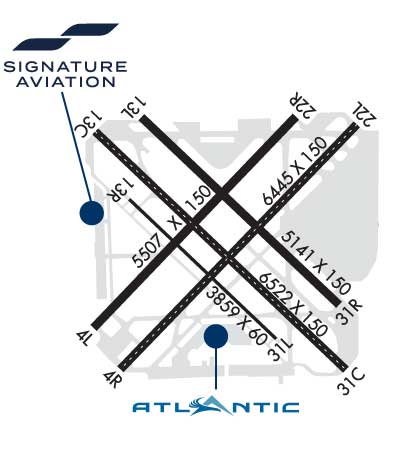
| Lat: N 4147.2 Long: W 08745.1 Elev: 620 Var: +04 Longest Runway: 6522 | ||
| Clr Del: 124.62 Dept. ATIS: 132.75 Arr. ATIS: 132.75 AWOS: 132.75 Ground: 121.65 Tower: 135.2 | ||
| |||||||||||||||||||||||||||||||||||||||||||||||||||||||||||||||||||||
| |||||||||||||||||||||||||||||||||||||||||||||||||||||||||||||||||||||
| |||||||||||||||||||||||||||||||||||||||||||||||||||||||||||||||||||||
| |||||||||||||||||||||||||||||||||||||||||||||||||||||||||||||||||||||
| |||||||||||||||||||||||||||||||||||||||||||||||||||||||||||||||||||||
| |||||||||||||||||||||||||||||||||||||||||||||||||||||||||||||||||||||
| Rwy | Rwy | |||||||
| 5507x150 | 4749' | 5507x150 | 4629' | |||||
| 6445x150 | 5927' | 111.50 - 047° | 6445x150 | 5810' | ||||
| 6522x150 | 6059' | 109.90 - 137° | 6522x150 | 5826' | 109.90 - 317° | |||
| 5141x150 | 4389' | 5141x150 | 5141' | |||||
| 3859x60 | 3859' | 3859x60 | 3859' | |||||
| Runway ID | Single Wheel | Double Wheel | Double Tandem Wheel | Dual Double Wheel |
| 04L/22R | 60,000 | 120,000 | N/A | N/A |
| 04R/22L | 95,000 | 165,000 | 250,000 | N/A |
| 13C/31C | 95,000 | 165,000 | 250,000 | N/A |
| 13L/31R | 80,000 | 125,000 | N/A | N/A |
| 13R/31L | 12,500 | N/A | N/A | N/A |
| These numbers are Advisory and are not limits. The Airport Manager should have more accurate Weight Limits | ||||
 Airport Diagram might not be current. | |
| Facility Name: | CHICAGO MIDWAY INTL |
| City Name: | CHICAGO |
| County: | COOK |
| State abbrev: | IL |
| State Name: | ILLINOIS |
| Ownership: | PUBLICLY OWNED |
| Use: | OPEN TO THE PUBLIC |
| Owner's Name: | CITY OF CHICAGO |
| Address: | 5700 S. CICERO |
| CHICAGO, IL 60638 | |
| Owner's Phone: | 773-838-0608 |
| Manager's Name: | JAMIE RHEE |
| Address: | 10510 WEST ZEMKE ROAD |
| CHICAGO, IL 60666 | |
| Phone: | 773-894-5492; ARPT OPNS 773-838-0677. |
| FAA Region: | GREAT LAKES |
| FAA Field Office: | CHI |

| Date | Sunrise | Sunset |
|---|---|---|
| 09/24/21 Friday | 6:40 | 18:45 |
| 09/25/21 Saturday | 6:41 | 18:43 |
| 09/26/21 Sunday | 6:42 | 18:42 |
| 09/27/21 Monday | 6:43 | 18:40 |
| 09/28/21 Tuesday | 6:44 | 18:38 |
| 09/29/21 Wednesday | 6:45 | 18:36 |
| 09/30/21 Thursday | 6:47 | 18:35 |
| 10/01/21 Friday | 6:48 | 18:33 |
| 10/02/21 Saturday | 6:49 | 18:31 |
| 10/03/21 Sunday | 6:50 | 18:30 |
| 10/04/21 Monday | 6:51 | 18:28 |
| 10/05/21 Tuesday | 6:52 | 18:26 |
| 10/06/21 Wednesday | 6:53 | 18:25 |
| 10/07/21 Thursday | 6:54 | 18:23 |
| Airport Attendance Schedule | CONTINUOUS |
| Airport Status | OPERATIONAL (This Status can change at any time - please check NOTAMS) |
| Airport Lighting Schedule | |
| Airport Storage Available | Tie Downs, Hanger |
| Extra Services Available | Air Freight, Air Ambulance, Avionics, Cargo Handling, Charter, Flight Instruction |
| Wind Indicator | YES - (lighted) |
| Control Tower | YES |
| CTAF Frequency | |
| Unicom Frequency | 122.950 |
| Rotating Beacon Color | CLEAR-GREEN (Light Land Airport) |
| Segmented Circle | NO |
| Landing Fee | NO |
| Airport Inspected | FEDERAL - performed by FAA AIRPORTS FIELD PERSONNEL |
| Inspection Date | 10/06/2020 |
| Type of Fuel Available | Grade 100LL, JET A-1 (icing inhibitor, freeze point -50C) |
| Airframe Repair Service | MAJOR |
| Power Plant Repair Service | MAJOR |
| Latitude | N4147.2 |
| Longitude | W08745.1 (ESTIMATED) |
| Arpt Elevation | 619ft (SURVEYED) |
| Magnetic Variation | 04W |
| 9 miles SW | of CHICAGO |
| Traffic Pattern Altitude | |
| Sectional Chart | CHICAGO |
| Operations (Reported) | Yearly | Avg. Daily |
|---|---|---|
| General Aviation Transient | 32922 | 90 |
| General Aviation Local | 0 | 0 |
| Air Taxi | 26988 | 74 |
| Commerical | 171926 | 471 |
| Commuter | 0 | 0 |
| Military | 248 | 1 |
| Aircraft based on Field | |
|---|---|
| General Aviation Singles | 9 |
| General Aviation Multi | 1 |
| Jet Aircraft | 30 |
| General Aviation Helicopters | 1 |
| Military Aircraft | 0 |
| Gliders | 0 |
| Ultralights | 0 |
| FSS on field | NO |
| FSS tie-in | KANKAKEE |
| FSS Phone | 1-800-WX-BRIEF |
| Who issues Notams | MDW |
| Notam D service at airport | YES |
| ARTCC Name | CHICAGO |
| Airport Certification | AIRPORT RECEIVING SCHEDULED AIR CARRIER SERVICE FROM CARRIERS CERTIFICATED BY THE CIVIL AERONAUTICS BOARD; ARFF INDEX "D" EQPT AVBL WITH 8 HRS NOTIFICATION TO ARPT OPNS 773-838-0677. |
| Aircraft Rescue & Firefighting Index | AIRPORT HAS A CERTIFICATE UNDER CFR PART 139 |
| Airport of Entry | YES |
| Custom Landing Rights | YES |
| Joint Civil/Military | No |
| Military Landing rights | YES |
| NATIONAL PLAN OF INTEGRATED AIRPORT SYSTEMS (NPIAS) |
| GRANT AGREEMENTS UNDER FAAP/ADAP/AIP |
| ASSURANCES PURSUANT TO TITLE VI, CIVIL RIGHTS ACT OF 1964 |
| AGREEMENT UNDER DLAND OR DCLA HAS EXPIRED. |
| TWY A CLSD TO ACFT OVR 94 FT WINGSPAN. |
| ASDE-X IN USE. OPERATE TRANSPONDERS WITH ALTITUDE REPORTING MODE AND ADS-B (IF EQUIPPED) ENABLED ON ALL AIRPORT SURFACES. |
| TWY F CLSD TO ACFT OVR 94 FT WINGSPAN. |
| RY 13R/31L CLSD TO FLT OPS WHEN ACFT OVR 79 FT WINGSPAN ARE ON TWY F. |
| NOISE ABATEMENT PROCEDURES: ALL DEPARTURES ARE REQUESTED TO EXPEDITE CLIMB THROUGH 1500 FT MSL 2200-0600 DLY. |
| ARPT CLSD TO SOLO STUDENT TRAINING. |
| BIRDS ON & INVOF ARPT. |
| CLOSE-IN OBST ALL RYS EXCEPT RY 13R/31L TOO NUMEROUS TO ITEMIZE. |
| RY 22L PREFERRED DEP RY 2200-0700. |
| RWY 13R/ 31LRWYS 13L/31R & 04L/22R NOT AVBL FOR SKEDD ACR OPNS WITH MORE THAN 9 PSGR SEATS OR UNSCHEDULED ACR AT LEAST 31 PSGR SEATS. |
Airport Communications & Frequencies:
| ||||||||||||||||||||||||||||||||||
| Runway: 04L | Runway: 22R | ||
| Mag heading: | 47° | Mag heading: | 227° |
| Rwy Slope: | -.24% Down | Rwy Slope: | .24% Up |
| Approach: | Approach: | ||
| Pattern: | Left Traffic | Pattern: | Left Traffic |
| Markings: | NONPRECISION INSTRUMENT | Markings: | NONPRECISION INSTRUMENT |
| Marking Condition: | GOOD | Marking Condition: | GOOD |
| Arresting Dev: | Arresting Dev: | ||
| Lat & Long: | N4146.9 W08745.7 | Lat. & Long.: | N4147.5 W08744.8 |
| Elev: | 618.5 ft. MSL | Elev: | 605.2 ft. MSL |
| TCH: | 39 ft. AGL | TCH: | 35 ft. AGL |
| Visual Glide Path: | 3.00 degrees | Visual Glide Path: | 3.00 degrees |
| Displaced Threshold: | 758 feet | Displaced Threshold: | 878 feet |
| Touchdown Zone: | YES | Touchdown Zone: | YES |
| Touchdown Elev.: | 617.2 feet | Touchdown Elev.: | 613.5 feet |
| Visual Glide Slope: | 4-Light PAPI on LEFT side of Runway | Visual Glide Slope: | 4-Light PAPI on LEFT side of Runway |
| RVR Equipment: | RVR Equipment: | ||
| RVV Equipment: | NO | RVV Equipment: | NO |
| Approach Lights: | Approach Lights: | ||
| REIL: | NO | REIL: | NO |
| Centerline Lights: | NO | Centerline Lights: | NO |
| Touchdown lights: | NO | Touchdown lights: | NO |
| Runway Category: | Runway with a Non-precision Approach having visibility minimums greater than 3/4 mile | Runway Category: | Runway with a Non-precision Approach having visibility minimums greater than 3/4 mile |
| Declared Distances: | TORA:5507' TODA:5507' ASDA:5507' LDA:4749' | Declared Distances: | TORA:5507' TODA:5507' ASDA:5507' LDA:4629' |
| Obstructions: | ROAD | Obstructions: | ROAD |
| Marked: | NOT Marked/Lighted | Marked: | NOT Marked/Lighted |
| Clearance slope: | RWY 04L APCH RATIO 19:1 AT DSPLCD THLD. TREES 178 FT L 1313 FT FROM DSPLCD THLD. | Clearance slope: | RWY 22R APCH RATIO 37:1 AT DSPLCD THR. TREE 2490 FT FROM DSPLCD THR 319 FT L. |
| Obstruction height: | 15 feet AGL | Obstruction height: | 15 feet AGL |
| Dist. from runway: | 200 feet | Dist. from runway: | 200 feet |
| Centerline offset: | 25 left of centerline | Centerline offset: | 125 feet right of centerline |
| Comments: | Comments: |
| Runway: 04R | Runway: 22L | ||
| Mag heading: | 47° | Mag heading: | 227° |
| Rwy Slope: | -.22% Down | Rwy Slope: | .22% Up |
| Approach: | ILS/DME | Approach: | |
| Pattern: | Left Traffic | Pattern: | Left Traffic |
| Markings: | PRECISION INSTRUMENT | Markings: | PRECISION INSTRUMENT |
| Marking Condition: | GOOD | Marking Condition: | GOOD |
| Arresting Dev: | EMAS; ENGINEERED MATERIALS ARRESTING SYSTEM (EMAS) 249 FT IN LENGTH BY 170 FT IN WIDTH LCTD AT THE DER 04R. | Arresting Dev: | EMAS; ENGINEERED MATERIALS ARRESTING SYSTEM (EMAS) 346 FT IN LENGTH BY 170 FT IN WIDTH LCTD AT THE DER 22L. |
| Lat & Long: | N4146.7 W08745.6 | Lat. & Long.: | N4147.5 W08744.6 |
| Elev: | 619.7 ft. MSL | Elev: | 605.2 ft. MSL |
| TCH: | 66 ft. AGL | TCH: | 43 ft. AGL |
| Visual Glide Path: | 3.00 degrees | Visual Glide Path: | 3.00 degrees |
| Displaced Threshold: | 518 feet | Displaced Threshold: | 635 feet |
| Touchdown Zone: | YES | Touchdown Zone: | YES |
| Touchdown Elev.: | 619.2 feet | Touchdown Elev.: | 611.0 feet |
| Visual Glide Slope: | 4-Light PAPI on LEFT side of Runway | Visual Glide Slope: | 4-Light PAPI on RIGHT side of Runway |
| RVR Equipment: | TOUCHDOWN-ROLLOUT | RVR Equipment: | TOUCHDOWN-ROLLOUT |
| RVV Equipment: | NO | RVV Equipment: | NO |
| Approach Lights: | Approach Lights: | ||
| REIL: | YES | REIL: | YES |
| Centerline Lights: | YES | Centerline Lights: | YES |
| Touchdown lights: | NO | Touchdown lights: | NO |
| Runway Category: | Precision Instrument Runway | Runway Category: | Runway with a Non-precision Approach having visibility minimums greater than 3/4 mile |
| Declared Distances: | TORA:6446' TODA:6446' ASDA:6446' LDA:5928' | Declared Distances: | TORA:6446' TODA:6446' ASDA:6446' LDA:5812' |
| Obstructions: | ROAD | Obstructions: | ROAD |
| Marked: | NOT Marked/Lighted | Marked: | NOT Marked/Lighted |
| Clearance slope: | RWY 04R APCH RATIO 16:1 AT DSPLCD THLD. TREE 547 FT R 1122 FT FROM DSPLCD THLD. | Clearance slope: | RWY 22L APCH RATIO 19:1 AT DSPLCD THLD. LGT POLE 474 FT R 674 FT FROM DSPLCD THLD. |
| Obstruction height: | 15 feet AGL | Obstruction height: | 15 feet AGL |
| Dist. from runway: | 200 feet | Dist. from runway: | 200 feet |
| Centerline offset: | 325 right of centerline | Centerline offset: | 350 feet left of centerline |
| Comments: | Comments: |
| Runway: 13C | Runway: 31C | ||
| Mag heading: | 138° | Mag heading: | 318° |
| Rwy Slope: | .07% Up | Rwy Slope: | -.07% Down |
| Approach: | ILS/DME | Approach: | ILS/DME |
| Pattern: | Left Traffic | Pattern: | Left Traffic |
| Markings: | PRECISION INSTRUMENT | Markings: | PRECISION INSTRUMENT |
| Marking Condition: | GOOD | Marking Condition: | GOOD |
| Arresting Dev: | EMAS; ENGINEERED MATERIALS ARRESTING SYSTEM (EMAS) 190 FT IN LENGTH BY 170 FT IN WIDTH LCTD AT THE DER 13C. | Arresting Dev: | EMAS; ENGINEERED MATERIALS ARRESTING SYSTEM (EMAS) 210 FT IN LENGTH BY 170 FT IN WIDTH LCTD AT THE DER 31C. |
| Lat & Long: | N4147.5 W08745.7 | Lat. & Long.: | N4146.8 W08744.6 |
| Elev: | 607.0 ft. MSL | Elev: | 611.6 ft. MSL |
| TCH: | 47 ft. AGL | TCH: | 63 ft. AGL |
| Visual Glide Path: | 3.00 degrees | Visual Glide Path: | 3.00 degrees |
| Displaced Threshold: | 463 feet | Displaced Threshold: | 696 feet |
| Touchdown Zone: | YES | Touchdown Zone: | YES |
| Touchdown Elev.: | 610.6 feet | Touchdown Elev.: | 612.7 feet |
| Visual Glide Slope: | 4-Light PAPI on RIGHT side of Runway | Visual Glide Slope: | 4-Light PAPI on LEFT side of Runway |
| RVR Equipment: | TOUCHDOWN-ROLLOUT | RVR Equipment: | TOUCHDOWN-ROLLOUT |
| RVV Equipment: | NO | RVV Equipment: | NO |
| Approach Lights: | RLLS | Approach Lights: | RLLS |
| REIL: | NO | REIL: | YES |
| Centerline Lights: | YES | Centerline Lights: | YES |
| Touchdown lights: | NO | Touchdown lights: | NO |
| Runway Category: | Precision Instrument Runway | Runway Category: | Precision Instrument Runway |
| Declared Distances: | TORA:6522' TODA:6522' ASDA:6522' LDA:6059' | Declared Distances: | TORA:6522' TODA:6522' ASDA:6522' LDA:5826' |
| Obstructions: | ROAD | Obstructions: | ROAD |
| Marked: | NOT Marked/Lighted | Marked: | NOT Marked/Lighted |
| Clearance slope: | RWY 13C APCH RATIO 16:1 AT DSPLCD THLD. TREE 453 FT R 915 FT FROM DSPLCD THLD. | Clearance slope: | RWY 31C APCH RATIO 24:1 AT DSPLCD THR. TREE 1211 FT FROM DSPLCD THR 459 FT R. |
| Obstruction height: | 15 feet AGL | Obstruction height: | 47 feet AGL |
| Dist. from runway: | 200 feet | Dist. from runway: | 200 feet |
| Centerline offset: | 225 right of centerline | Centerline offset: | 225 feet left of centerline |
| Comments: | Comments: |
| Runway: 13L | Runway: 31R | ||
| Mag heading: | 138° | Mag heading: | 318° |
| Rwy Slope: | .04% Up | Rwy Slope: | -.04% Down |
| Approach: | Approach: | ||
| Pattern: | Left Traffic | Pattern: | Left Traffic |
| Markings: | NONPRECISION INSTRUMENT | Markings: | NONPRECISION INSTRUMENT |
| Marking Condition: | GOOD | Marking Condition: | GOOD |
| Arresting Dev: | Arresting Dev: | ||
| Lat & Long: | N4147.5 W08745.5 | Lat. & Long.: | N4147.0 W08744.7 |
| Elev: | 606.1 ft. MSL | Elev: | 608.3 ft. MSL |
| TCH: | TCH: | 44 ft. AGL | |
| Visual Glide Path: | Visual Glide Path: | 3.00 degrees | |
| Displaced Threshold: | 752 feet | Displaced Threshold: | No |
| Touchdown Zone: | YES | Touchdown Zone: | YES |
| Touchdown Elev.: | 609.1 feet | Touchdown Elev.: | 609.9 feet |
| Visual Glide Slope: | Visual Glide Slope: | 4-Light PAPI on LEFT side of Runway; UNUSBL BYD 7 DEGS RIGHT & LEFT OF CNTRLN. | |
| RVR Equipment: | RVR Equipment: | ||
| RVV Equipment: | NO | RVV Equipment: | NO |
| Approach Lights: | Approach Lights: | ||
| REIL: | NO | REIL: | NO |
| Centerline Lights: | NO | Centerline Lights: | NO |
| Touchdown lights: | NO | Touchdown lights: | NO |
| Runway Category: | Runway with a Non-precision Approach having visibility minimums greater than 3/4 mile | Runway Category: | Runway with a Non-precision Approach having visibility minimums greater than 3/4 mile |
| Declared Distances: | TORA:5141' TODA:5141' ASDA:5141' LDA:4388' | Declared Distances: | TORA:5141' TODA:5141' ASDA:5141' LDA:5141' |
| Obstructions: | ROAD | Obstructions: | POLE |
| Marked: | NOT Marked/Lighted | Marked: | LIGHTED |
| Clearance slope: | APCH RATIO 1:1 AT DSPLCD THLD. HGR 275 FT L 450 FT DSTC. | Clearance slope: | 13:1 |
| Obstruction height: | 15 feet AGL | Obstruction height: | 34 feet AGL |
| Dist. from runway: | 200 feet | Dist. from runway: | 656 feet |
| Centerline offset: | Centerline offset: | 285 feet right of centerline | |
| Comments: | Comments: |
| Runway: 13R | Runway: 31L | ||
| Mag heading: | 138° | Mag heading: | 318° |
| Rwy Slope: | .16% Up | Rwy Slope: | -.16% Down |
| Approach: | Approach: | ||
| Pattern: | Left Traffic | Pattern: | Left Traffic |
| Markings: | BASIC | Markings: | BASIC |
| Marking Condition: | GOOD | Marking Condition: | GOOD |
| Arresting Dev: | Arresting Dev: | ||
| Lat & Long: | N4147.3 W08745.5 | Lat. & Long.: | N4146.8 W08744.9 |
| Elev: | 606.9 ft. MSL | Elev: | 612.9 ft. MSL |
| TCH: | TCH: | ||
| Visual Glide Path: | Visual Glide Path: | ||
| Displaced Threshold: | No | Displaced Threshold: | No |
| Touchdown Zone: | YES | Touchdown Zone: | YES |
| Touchdown Elev.: | 611.7 feet | Touchdown Elev.: | 613.0 feet |
| Visual Glide Slope: | Visual Glide Slope: | ||
| RVR Equipment: | RVR Equipment: | ||
| RVV Equipment: | NO | RVV Equipment: | NO |
| Approach Lights: | Approach Lights: | ||
| REIL: | NO | REIL: | NO |
| Centerline Lights: | NO | Centerline Lights: | NO |
| Touchdown lights: | NO | Touchdown lights: | NO |
| Runway Category: | Runway with a Visual Approach | Runway Category: | Runway with a Visual Approach |
| Declared Distances: | Declared Distances: | ||
| Obstructions: | TREE | Obstructions: | TREE |
| Marked: | NOT Marked/Lighted | Marked: | NOT Marked/Lighted |
| Clearance slope: | 23:1 | Clearance slope: | 26:1 |
| Obstruction height: | 55 feet AGL | Obstruction height: | 59 feet AGL |
| Dist. from runway: | 1504 feet | Dist. from runway: | 1737 feet |
| Centerline offset: | 214 right of centerline | Centerline offset: | 147 feet right of centerline |
| Comments: | Comments: |
Thanks for using FltPlan.com
all rights reserved © 1999-2021 by Flight Plan LLC


