| KANSAS CITY INTL KANSAS CITY MO |
| |
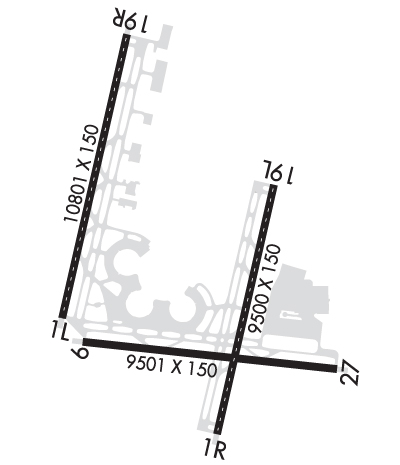
| Lat: N 3917.9 Long: W 09442.8 Elev: 1027 Var: -02 Longest Runway: 10801 | ||
| Clr Del: 135.7 Dept. ATIS: 128.37 Arr. ATIS: 128.37 Ground: 121.65/121.8 Tower: 125.75/128.2 | ||
| ||||||||||||||||||||||||||||||||||||||||||||
| ||||||||||||||||||||||||||||||||||||||||||||
| ||||||||||||||||||||||||||||||||||||||||||||
| ||||||||||||||||||||||||||||||||||||||||||||
| ||||||||||||||||||||||||||||||||||||||||||||
| FBOs at nearby airports who want your business: | |||||||||||||||||
| |||||||||||||||||
| Rwy | Rwy | |||||||
| 10801x150 | 10801' | 110.50 - 010° | 10801x150 | 10801' | 109.10 - 190° | |||
| 9500x150 | 9500' | 110.75 - 010° | 9500x150 | 9500' | 109.55 - 190° | |||
| 9501x150 | 9501' | 109.70 - 094° | 9501x150 | 9501' | 109.70 - 274° | |||
| Runway ID | Single Wheel | Double Wheel | Double Tandem Wheel | Dual Double Wheel |
| 01L/19R | 120,000 | 250,000 | 524,000 | 450,000 |
| 01R/19L | 120,000 | 250,000 | 550,000 | 450,000 |
| 09/27 | 120,000 | 250,000 | 465,000 | 260,000 |
| These numbers are Advisory and are not limits. The Airport Manager should have more accurate Weight Limits | ||||
 Airport Diagram might not be current. | |
| Facility Name: | KANSAS CITY INTL |
| City Name: | KANSAS CITY |
| County: | PLATTE |
| State abbrev: | MO |
| State Name: | MISSOURI |
| Ownership: | PUBLICLY OWNED |
| Use: | OPEN TO THE PUBLIC |
| Owner's Name: | CITY OF KANSAS CITY |
| Address: | 601 BRASILIA; PO BOX 20047 |
| KANSAS CITY, MO 64141 | |
| Owner's Phone: | 816-243-3100 |
| Manager's Name: | MR. LUKE MAWHIRTER |
| Address: | P.O. BOX 20047 |
| KANSAS CITY, MO 64195 | |
| Phone: | 816-243-5248 |
| FAA Region: | CENTRAL |
| FAA Field Office: | NONE |

| Date | Sunrise | Sunset |
|---|---|---|
| 06/07/26 Sunday | 5:52 | 20:43 |
| 06/08/26 Monday | 5:52 | 20:44 |
| 06/09/26 Tuesday | 5:52 | 20:44 |
| 06/10/26 Wednesday | 5:52 | 20:45 |
| 06/11/26 Thursday | 5:52 | 20:45 |
| 06/12/26 Friday | 5:52 | 20:46 |
| 06/13/26 Saturday | 5:52 | 20:46 |
| 06/14/26 Sunday | 5:52 | 20:47 |
| 06/15/26 Monday | 5:52 | 20:47 |
| 06/16/26 Tuesday | 5:52 | 20:47 |
| 06/17/26 Wednesday | 5:52 | 20:48 |
| 06/18/26 Thursday | 5:52 | 20:48 |
| 06/19/26 Friday | 5:52 | 20:48 |
| 06/20/26 Saturday | 5:52 | 20:49 |
| Airport Attendance Schedule | CONTINUOUS |
| Airport Status | OPERATIONAL (This Status can change at any time - please check NOTAMS) |
| Airport Lighting Schedule | |
| Airport Storage Available | Tie Downs |
| Extra Services Available | Cargo Handling |
| Wind Indicator | YES - (lighted) |
| Control Tower | YES |
| CTAF Frequency | |
| Unicom Frequency | 122.950 |
| Rotating Beacon Color | WG |
| Segmented Circle | NO |
| Landing Fee | NO |
| Airport Inspected | FEDERAL - performed by FAA AIRPORTS FIELD PERSONNEL |
| Inspection Date | 08/06/2025 |
| Type of Fuel Available | Grade 100LL, JET A (freeze point -40C) |
| Airframe Repair Service | NONE |
| Power Plant Repair Service | NONE |
| Latitude | N3917.9 |
| Longitude | W09442.8 (ESTIMATED) |
| Arpt Elevation | 1026ft (SURVEYED) |
| Magnetic Variation | 02E |
| 15 miles NW | of KANSAS CITY |
| Traffic Pattern Altitude | |
| Sectional Chart | KANSAS CITY |
| Operations (Reported) | Yearly | Avg. Daily |
|---|---|---|
| General Aviation Transient | 0 | 0 |
| General Aviation Local | 0 | 0 |
| Air Taxi | 0 | 0 |
| Commerical | 0 | 0 |
| Commuter | 0 | 0 |
| Military | 0 | 0 |
| Aircraft based on Field | |
|---|---|
| General Aviation Singles | 0 |
| General Aviation Multi | 0 |
| Jet Aircraft | 0 |
| General Aviation Helicopters | 0 |
| Military Aircraft | 0 |
| Gliders | 0 |
| Ultralights | 0 |
| FSS on field | NO |
| FSS tie-in | COLUMBIA |
| FSS Phone | 1-800-WX-BRIEF |
| Who issues Notams | MCI |
| Notam D service at airport | YES |
| ARTCC Name | KANSAS CITY |
| Airport Certification | AIRPORT RECEIVING SCHEDULED AIR CARRIER SERVICE FROM CARRIERS CERTIFICATED BY THE CIVIL AERONAUTICS BOARD |
| Aircraft Rescue & Firefighting Index | AIRPORT HAS A CERTIFICATE UNDER CFR PART 139 |
| Airport of Entry | No |
| Custom Landing Rights | YES |
| Joint Civil/Military | No |
| Military Landing rights | YES |
| NATIONAL PLAN OF INTEGRATED AIRPORT SYSTEMS (NPIAS) |
| GRANT AGREEMENTS UNDER FAAP/ADAP/AIP |
| ASSURANCES PURSUANT TO TITLE VI, CIVIL RIGHTS ACT OF 1964 |
| WATERFOWL ON AND INVOF ARPT. |
| PPR TO PARK AT TRML GATES CTC ARPT OPN 816-835-4315 |
| WHEN USING HIGH-SPEED EXITS C4 & C6 CONT TIL FIRST PARL TWY, THEN USE EXTREME CARE WHEN TURNING IN EXCESS OF 90 DEGREES. |
| NO ACFT PARKING ON POSTAL APRON. |
| DESIGN GROUP V AND VI ACFT RQR AN ARPT ESCORT ON TWY DELTA BTWN TWYS JULIET & C9. |
| TWY B1 BTN TWY B AND FEDEX APN COCKPIT OVER CNTRLN STEERING RQRD |
| TWY C2 BTN TWY C3 AND TWY C1 WINGSPAN RESTRICTION OF 118 FT. |
| TXL W, N1, N3, M1, M3, S1, S3, D1, & D3 WINGSPAN RESTRICTION OF 118 FT. |
| N RAMP CTL FREQ: 128.975 |
| S RAMP CTL FREQ: 130.825 |
| TWY B2 CLSD TO ACFT WINGSPAN MORE THAN 135FT. |
| WINDSHEAR ALERT SYSTEM ON ARPT. |
| NOISE ABATEMENT PROCEDURES IN EFFECT 2200-0600 WITH LANDING ON RYS 01L & 19L; TAKEOFFS ON RYS 01R & 19R. |
| MIL ACFT MAY BE CHARGED RAMP/PARKING FEES. |
| RWY 01L/ 19RPCR VALUE: 1106/R/D/W/T |
| RWY 01R/ 19LPCR VALUE: 1107/R/B/W/T |
| RWY 09/2 7 PCR VALUE: 646/F/B/X/T |
Airport Communications & Frequencies:
| |||||||||||||||||||||||||||||||||||||||||||||||||||||||
| Runway: 01L | Runway: 19R | ||
| Mag heading: | 11° | Mag heading: | 191° |
| Rwy Slope: | -.32% Down | Rwy Slope: | .32% Up |
| Approach: | ILS/DME | Approach: | ILS/DME |
| Pattern: | Left Traffic | Pattern: | Right Traffic |
| Markings: | PRECISION INSTRUMENT | Markings: | PRECISION INSTRUMENT |
| Marking Condition: | GOOD | Marking Condition: | GOOD |
| Arresting Dev: | Arresting Dev: | ||
| Lat & Long: | N3917.6 W09443.8 | Lat. & Long.: | N3919.3 W09443.2 |
| Elev: | 1014.4 ft. MSL | Elev: | 979.6 ft. MSL |
| TCH: | 78 ft. AGL | TCH: | 80 ft. AGL |
| Visual Glide Path: | 3.00 degrees | Visual Glide Path: | 3.00 degrees |
| Displaced Threshold: | No | Displaced Threshold: | No |
| Touchdown Zone: | YES | Touchdown Zone: | YES |
| Touchdown Elev.: | 1014.4 feet | Touchdown Elev.: | 990.5 feet |
| Visual Glide Slope: | 4-Light PAPI on LEFT side of Runway | Visual Glide Slope: | 4-Light PAPI on RIGHT side of Runway |
| RVR Equipment: | TOUCHDOWN-MIDFIELD-ROLLOUT | RVR Equipment: | TOUCHDOWN-MIDFIELD-ROLLOUT |
| RVV Equipment: | NO | RVV Equipment: | NO |
| Approach Lights: | MALSR - 1,400 foot medium intensity approach lighting system with runway alignment indicator lights | Approach Lights: | ALSF2 - standard 2,400 foot high intensity approach lighting system with sequenced flashers, Category II or III |
| REIL: | NO | REIL: | NO |
| Centerline Lights: | YES | Centerline Lights: | YES |
| Touchdown lights: | YES | Touchdown lights: | YES |
| Runway Category: | Precision Instrument Runway | Runway Category: | Precision Instrument Runway |
| Declared Distances: | TORA:10801' TODA:10801' ASDA:10801' LDA:10801' | Declared Distances: | TORA:10801' TODA:10801' ASDA:10801' LDA:10801' |
| Runway: 01R | Runway: 19L | ||
| Mag heading: | 11° | Mag heading: | 191° |
| Rwy Slope: | -.41% Down | Rwy Slope: | .41% Up |
| Approach: | ILS/DME | Approach: | ILS/DME |
| Pattern: | Left Traffic | Pattern: | Left Traffic |
| Markings: | PRECISION INSTRUMENT | Markings: | PRECISION INSTRUMENT |
| Marking Condition: | GOOD | Marking Condition: | GOOD |
| Arresting Dev: | Arresting Dev: | ||
| Lat & Long: | N3916.9 W09442.5 | Lat. & Long.: | N3918.4 W09442.1 |
| Elev: | 1017.2 ft. MSL | Elev: | 978.5 ft. MSL |
| TCH: | 74 ft. AGL | TCH: | |
| Visual Glide Path: | 3.00 degrees | Visual Glide Path: | |
| Displaced Threshold: | No | Displaced Threshold: | No |
| Touchdown Zone: | YES | Touchdown Zone: | YES |
| Touchdown Elev.: | 1017.4 feet | Touchdown Elev.: | 995.2 feet |
| Visual Glide Slope: | 4-Light PAPI on RIGHT side of Runway | Visual Glide Slope: | |
| RVR Equipment: | TOUCHDOWN-MIDFIELD-ROLLOUT | RVR Equipment: | TOUCHDOWN-MIDFIELD-ROLLOUT |
| RVV Equipment: | NO | RVV Equipment: | NO |
| Approach Lights: | ALSF2 - standard 2,400 foot high intensity approach lighting system with sequenced flashers, Category II or III | Approach Lights: | MALSR - 1,400 foot medium intensity approach lighting system with runway alignment indicator lights |
| REIL: | NO | REIL: | NO |
| Centerline Lights: | YES | Centerline Lights: | YES |
| Touchdown lights: | YES | Touchdown lights: | YES |
| Runway Category: | Precision Instrument Runway | Runway Category: | Precision Instrument Runway |
| Declared Distances: | TORA:9500' TODA:9500' ASDA:9500' LDA:9500' | Declared Distances: | TORA:9500' TODA:9500' ASDA:9500' LDA:9500' |
| Runway: 09 | Runway: 27 | ||
| Mag heading: | 94° | Mag heading: | 274° |
| Rwy Slope: | .12% Up | Rwy Slope: | -.12% Down |
| Approach: | ILS/DME | Approach: | ILS/DME |
| Pattern: | Left Traffic | Pattern: | Right Traffic |
| Markings: | PRECISION INSTRUMENT | Markings: | PRECISION INSTRUMENT |
| Marking Condition: | GOOD | Marking Condition: | GOOD |
| Arresting Dev: | Arresting Dev: | ||
| Lat & Long: | N3917.5 W09443.6 | Lat. & Long.: | N3917.3 W09441.6 |
| Elev: | 1015.3 ft. MSL | Elev: | 1026.9 ft. MSL |
| TCH: | TCH: | 72 ft. AGL | |
| Visual Glide Path: | Visual Glide Path: | 3.00 degrees | |
| Displaced Threshold: | No | Displaced Threshold: | No |
| Touchdown Zone: | YES | Touchdown Zone: | YES |
| Touchdown Elev.: | 1015.7 feet | Touchdown Elev.: | 1026.9 feet |
| Visual Glide Slope: | Visual Glide Slope: | 4-Light PAPI on LEFT side of Runway | |
| RVR Equipment: | TOUCHDOWN-ROLLOUT | RVR Equipment: | TOUCHDOWN-ROLLOUT |
| RVV Equipment: | NO | RVV Equipment: | NO |
| Approach Lights: | MALSR - 1,400 foot medium intensity approach lighting system with runway alignment indicator lights | Approach Lights: | MALSR - 1,400 foot medium intensity approach lighting system with runway alignment indicator lights |
| REIL: | NO | REIL: | NO |
| Centerline Lights: | NO | Centerline Lights: | NO |
| Touchdown lights: | NO | Touchdown lights: | NO |
| Runway Category: | Precision Instrument Runway | Runway Category: | Precision Instrument Runway |
| Declared Distances: | TORA:9501' TODA:9501' ASDA:9501' LDA:9501' | Declared Distances: | TORA:9501' TODA:9501' ASDA:9501' LDA:9501' |
Thanks for using FltPlan.com
all rights reserved © 1999-2026 by Flight Plan LLC