
| MERCED REGIONAL//MACREADY FLD MERCED CA |
| |
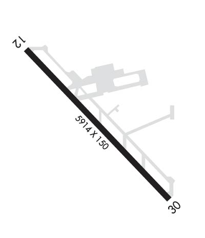
| Lat: N 3717.1 Long: W 12030.8 Elev: 155 Var: -15 Longest Runway: 5914 | ||
| AWOS: 132.17 CTAF: 122.7 | ||
| ||||||
| ||||||
|
| Rwy | Rwy | |||||||
| 5914x150 | 5914' | 5914x150 | 5914' | 109.30 - 303° | ||||
| Runway ID | Single Wheel | Double Wheel | Double Tandem Wheel | Dual Double Wheel |
| 12/30 | 30,000 | 100,000 | 155,000 | N/A |
| These numbers are Advisory and are not limits. The Airport Manager should have more accurate Weight Limits | ||||
 Airport Diagram might not be current. | |
| Facility Name: | MERCED RGNL/MACREADY FLD |
| City Name: | MERCED |
| County: | MERCED |
| State abbrev: | CA |
| State Name: | CALIFORNIA |
| Ownership: | PUBLICLY OWNED |
| Use: | OPEN TO THE PUBLIC |
| Owner's Name: | CITY OF MERCED |
| Address: | 678 WEST 18TH ST. |
| MERCED, CA 95340 | |
| Owner's Phone: | 209-564-0120; 24 HOURS |
| Manager's Name: | MARTIN PEHL; EMAIL: PEHLM@CITYOFMERCED.ORG |
| Address: | 20 MACREADY DR. |
| MERCED, CA 95341 | |
| Phone: | 209-385-6873; OR 209-564-0120 |
| FAA Region: | WESTERN-PACIFIC |
| FAA Field Office: | SFO |

| Date | Sunrise | Sunset |
|---|---|---|
| 09/24/21 Friday | 6:51 | 18:56 |
| 09/25/21 Saturday | 6:52 | 18:55 |
| 09/26/21 Sunday | 6:53 | 18:53 |
| 09/27/21 Monday | 6:54 | 18:52 |
| 09/28/21 Tuesday | 6:55 | 18:50 |
| 09/29/21 Wednesday | 6:56 | 18:48 |
| 09/30/21 Thursday | 6:56 | 18:47 |
| 10/01/21 Friday | 6:57 | 18:45 |
| 10/02/21 Saturday | 6:58 | 18:44 |
| 10/03/21 Sunday | 6:59 | 18:42 |
| 10/04/21 Monday | 7:00 | 18:41 |
| 10/05/21 Tuesday | 7:01 | 18:40 |
| 10/06/21 Wednesday | 7:02 | 18:38 |
| 10/07/21 Thursday | 7:03 | 18:37 |
| Airport Attendance Schedule | 7 Days A Week 0600-1800 |
| Airport Status | OPERATIONAL (This Status can change at any time - please check NOTAMS) |
| Airport Lighting Schedule | ACTVT MALSR RWY 30; REIL RWY 12; PAPI RWY 30; HIRL RWY 12/30 - CTAF; KEY 7 CLICKS HIGH, 5 CLICKS MED, 3 CLICKS LOW. VASI RWY 12 OPER CONSLY. |
| Airport Storage Available | Tie Downs |
| Extra Services Available | Air Freight, Charter, Flight Instruction, Aircraft Rental, Aircraft Sales |
| Wind Indicator | YES - (lighted) |
| Control Tower | NO |
| CTAF Frequency | 122.700 |
| Unicom Frequency | 122.700 |
| Rotating Beacon Color | CLEAR-GREEN (Light Land Airport) |
| Segmented Circle | YES |
| Landing Fee | NO |
| Airport Inspected | FEDERAL - performed by STATE AERONAUTICAL PERSONNEL |
| Inspection Date | 04/30/2021 |
| Type of Fuel Available | Grade 100LL, JET A (freeze point -40C); -10FOR FUEL AFT HRS CALL (209) 722-6300. SELF SERVICE 100LL AVBL 24/7. |
| Airframe Repair Service | MAJOR |
| Power Plant Repair Service | MAJOR |
| Latitude | N3717.1 |
| Longitude | W12030.8 (ESTIMATED) |
| Arpt Elevation | 155ft (SURVEYED) |
| Magnetic Variation | 15E |
| 2 miles SW | of MERCED |
| Traffic Pattern Altitude | |
| Sectional Chart | SAN FRANCISCO |
| Operations (Reported) | Yearly | Avg. Daily |
|---|---|---|
| General Aviation Transient | 32770 | 90 |
| General Aviation Local | 21880 | 60 |
| Air Taxi | 300 | 1 |
| Commerical | 3500 | 10 |
| Commuter | 0 | 0 |
| Military | 200 | 1 |
| Aircraft based on Field | |
|---|---|
| General Aviation Singles | 37 |
| General Aviation Multi | 2 |
| Jet Aircraft | 0 |
| General Aviation Helicopters | 0 |
| Military Aircraft | 0 |
| Gliders | 0 |
| Ultralights | 0 |
| FSS on field | NO |
| FSS tie-in | RANCHO MURIETA |
| FSS Phone | 1-800-WX-BRIEF |
| Who issues Notams | MCE |
| Notam D service at airport | YES |
| ARTCC Name | OAKLAND |
| Airport Certification | ARFF INDEX B 24 HOURS PPR |
| Aircraft Rescue & Firefighting Index | None |
| Airport of Entry | No |
| Custom Landing Rights | No |
| Joint Civil/Military | No |
| Military Landing rights | YES |
| NATIONAL PLAN OF INTEGRATED AIRPORT SYSTEMS (NPIAS) |
| GRANT AGREEMENTS UNDER FAAP/ADAP/AIP |
| ASSURANCES PURSUANT TO TITLE VI, CIVIL RIGHTS ACT OF 1964 |
| THIS AIRPORT HAS BEEN SURVEYED BY THE NATIONAL GEODETIC SURVEY. |
| NOISE ABATEMENT PROCEDURES IN EFFECT, RECOMMEND ACFT REMAIN EAST/WEST OF CITY OF MERCED AT ALT ABOVE 1,500 FT MSL. DEPARTING TFC RWY 12 NO LEFT TURNS OVER CITY UNTIL REACHING 3,000 FT MSL. |
| PPR 24 HRS FOR UNSKED ACFT OPNS WITH MORE THAN 30 PSGR SEATS CALL AMGR 209-564-0120. |
| RY 30 PREFERRED WIND RUNWAY. |
| BE ALERT FOR EXTENSIVE STUDENT TRAINING WITHIN 10 NMR OF AIRPORT. TWO-WAY RADIO COMMUNICATION RECOMMENDED. |
| INCRD SEAGULL ACT ON RWY IN PUDDLES. |
| FOR CD CTC NORCAL APCH AT 916-361-0516. |
Airport Communications & Frequencies:
| ||||||||||||||
| Runway: 12 | Runway: 30 | ||
| Mag heading: | 123° | Mag heading: | 303° |
| Rwy Slope: | .01% Up | Rwy Slope: | -.01% Down |
| Approach: | Approach: | ILS/DME | |
| Pattern: | Right Traffic | Pattern: | Left Traffic |
| Markings: | PRECISION INSTRUMENT | Markings: | PRECISION INSTRUMENT |
| Marking Condition: | GOOD | Marking Condition: | GOOD |
| Arresting Dev: | Arresting Dev: | ||
| Lat & Long: | N3717.4 W12031.2 | Lat. & Long.: | N3716.7 W12030.4 |
| Elev: | 154.8 ft. MSL | Elev: | 155.2 ft. MSL |
| TCH: | 53 ft. AGL | TCH: | 54 ft. AGL |
| Visual Glide Path: | 3.00 degrees | Visual Glide Path: | 3.00 degrees |
| Displaced Threshold: | No | Displaced Threshold: | No |
| Touchdown Zone: | YES | Touchdown Zone: | YES |
| Touchdown Elev.: | 155.0 feet | Touchdown Elev.: | 155.2 feet |
| Visual Glide Slope: | 4-BOX VASI ON LEFT SIDE OF RUNWAY | Visual Glide Slope: | 4-Light PAPI on LEFT side of Runway |
| RVR Equipment: | RVR Equipment: | ||
| RVV Equipment: | NO | RVV Equipment: | NO |
| Approach Lights: | Approach Lights: | MALSR - 1,400 foot medium intensity approach lighting system with runway alignment indicator lights | |
| REIL: | YES | REIL: | NO |
| Centerline Lights: | NO | Centerline Lights: | NO |
| Touchdown lights: | NO | Touchdown lights: | NO |
| Runway Category: | Runway with a Non-precision Approach having visibility minimums greater than 3/4 mile | Runway Category: | Precision Instrument Runway |
| Declared Distances: | Declared Distances: | ||
| Obstructions: | POLE | Obstructions: | PLINE |
| Marked: | MARKED and LIGHTED | Marked: | MARKED and LIGHTED |
| Clearance slope: | 30:1 | Clearance slope: | 38:1 |
| Obstruction height: | 20 feet AGL | Obstruction height: | 42 feet AGL |
| Dist. from runway: | 800 feet | Dist. from runway: | 1800 feet |
| Centerline offset: | 225 left of centerline | Centerline offset: | 650 feet left of centerline |
| Comments: | Comments: |
Thanks for using FltPlan.com
all rights reserved © 1999-2021 by Flight Plan LLC