
| MACKINAC ISLAND MACKINAC ISLAND MI |
| |
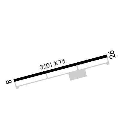
| Lat: N 4551.9 Long: W 08438.2 Elev: 741 Var: +07 Longest Runway: 3501 | ||
| AWOS: 118.27 CTAF: 122.7 | ||
| ||||||||||||||||||||||||||||||||
| ||||||||||||||||||||||||||||||||
| ||||||||||||||||||||||||||||||||
| Rwy | Rwy | |||||||
| 3501x75 | 3501' | 3501x75 | 3501' | |||||
| Runway ID | Single Wheel | Double Wheel | Double Tandem Wheel | Dual Double Wheel |
| 08/26 | 13,000 | N/A | N/A | N/A |
| These numbers are Advisory and are not limits. The Airport Manager should have more accurate Weight Limits | ||||
 Airport Diagram might not be current. | |
| Facility Name: | MACKINAC ISLAND |
| City Name: | MACKINAC ISLAND |
| County: | MACKINAC |
| State abbrev: | MI |
| State Name: | MICHIGAN |
| Ownership: | PUBLICLY OWNED |
| Use: | OPEN TO THE PUBLIC |
| Owner's Name: | MACKINAC ISLAND STATE PARK COMM. |
| Address: | BOX 370 |
| MACKINAC ISLAND, MI 49757 | |
| Owner's Phone: | 906-847-3231 |
| Manager's Name: | MYRON JOHNSON; ASST MGR - JUSTIN WRIGHT - 906-847-3231 |
| Address: | PO BOX 370 |
| MACKINAC ISLAND, MI 49757 | |
| Phone: | 906-847-3231 |
| FAA Region: | GREAT LAKES |
| FAA Field Office: | DET |

| Date | Sunrise | Sunset |
|---|---|---|
| 09/24/21 Friday | 7:28 | 19:33 |
| 09/25/21 Saturday | 7:29 | 19:31 |
| 09/26/21 Sunday | 7:30 | 19:29 |
| 09/27/21 Monday | 7:31 | 19:27 |
| 09/28/21 Tuesday | 7:33 | 19:25 |
| 09/29/21 Wednesday | 7:34 | 19:23 |
| 09/30/21 Thursday | 7:35 | 19:21 |
| 10/01/21 Friday | 7:37 | 19:19 |
| 10/02/21 Saturday | 7:38 | 19:17 |
| 10/03/21 Sunday | 7:39 | 19:15 |
| 10/04/21 Monday | 7:40 | 19:13 |
| 10/05/21 Tuesday | 7:42 | 19:11 |
| 10/06/21 Wednesday | 7:43 | 19:10 |
| 10/07/21 Thursday | 7:44 | 19:08 |
| Airport Attendance Schedule | 7 Days A Week 0800-1700 |
| Airport Status | OPERATIONAL (This Status can change at any time - please check NOTAMS) |
| Airport Lighting Schedule | ACTVT MIRL RY 08/26 & PAPI RYS 08 & 26 & REIL RYS 08 & 26 - 122.8. |
| Airport Storage Available | Tie Downs |
| Extra Services Available | NONE |
| Wind Indicator | YES - (lighted) |
| Control Tower | NO |
| CTAF Frequency | 122.700 |
| Unicom Frequency | 122.700 |
| Rotating Beacon Color | CLEAR-GREEN (Light Land Airport) |
| Segmented Circle | YES |
| Landing Fee | YES |
| Airport Inspected | STATE - performed by STATE AERONAUTICAL PERSONNEL |
| Inspection Date | 06/19/2019 |
| Type of Fuel Available | None |
| Airframe Repair Service | NONE |
| Power Plant Repair Service | NONE |
| Latitude | N4551.9 |
| Longitude | W08438.2 (ESTIMATED) |
| Arpt Elevation | 741ft (SURVEYED) |
| Magnetic Variation | 07W |
| 1 miles NW | of MACKINAC ISLAND |
| Traffic Pattern Altitude | 1159 |
| Sectional Chart | LAKE HURON |
| Operations (Reported) | Yearly | Avg. Daily |
|---|---|---|
| General Aviation Transient | 7500 | 21 |
| General Aviation Local | 100 | 0 |
| Air Taxi | 3500 | 10 |
| Commerical | 0 | 0 |
| Commuter | 0 | 0 |
| Military | 0 | 0 |
| Aircraft based on Field | |
|---|---|
| General Aviation Singles | 0 |
| General Aviation Multi | 1 |
| Jet Aircraft | 0 |
| General Aviation Helicopters | 0 |
| Military Aircraft | 0 |
| Gliders | 0 |
| Ultralights | 0 |
| FSS on field | NO |
| FSS tie-in | GREEN BAY |
| FSS Phone | 1-800-WX-BRIEF |
| Who issues Notams | MCD |
| Notam D service at airport | YES |
| ARTCC Name | MINNEAPOLIS |
| Airport Certification | |
| Aircraft Rescue & Firefighting Index | None |
| Airport of Entry | No |
| Custom Landing Rights | No |
| Joint Civil/Military | No |
| Military Landing rights | YES |
| NATIONAL PLAN OF INTEGRATED AIRPORT SYSTEMS (NPIAS) |
| GRANT AGREEMENTS UNDER FAAP/ADAP/AIP |
| ASSURANCES PURSUANT TO TITLE VI, CIVIL RIGHTS ACT OF 1964 |
| BIRDS ON & INVOF ARPT. FLOCKS OF SEAGULLS INVOF LANDFILL, 0.3 MI NE. |
| NOISE ABATEMENT PROCEDURES: TRAFFIC PATTERN ALT 1900 FT MSL; CLIMB TO 1900 FT MSL BEFORE TURNING; AVOID FLIGHT OVER SHORE & TOWN; NO TOUCH & GO LANDINGS. |
| OBSTRUCTION LIGHTS ARE IN THE APPROACH TO RUNWAY 26. |
| PILOTS ARE ENCOURAGED TO USE PITOT COVERS WHILE PARKED AND TO CHECK TUBES PRIOR TO DEPARTURE DUE TO MUD DAUBERS |
| FOR CD CTC MINNEAPOLIS ARTCC AT 651-463-5588. |
Airport Communications & Frequencies:
| |||||||||
| Runway: 08 | Runway: 26 | ||
| Mag heading: | 82° | Mag heading: | 262° |
| Rwy Slope: | .35% Up | Rwy Slope: | -.35% Down |
| Approach: | Approach: | ||
| Pattern: | Left Traffic | Pattern: | Left Traffic |
| Markings: | NONPRECISION INSTRUMENT | Markings: | NONPRECISION INSTRUMENT |
| Marking Condition: | GOOD | Marking Condition: | GOOD |
| Arresting Dev: | Arresting Dev: | ||
| Lat & Long: | N4551.8 W08438.6 | Lat. & Long.: | N4552.0 W08437.8 |
| Elev: | 728.7 ft. MSL | Elev: | 741.0 ft. MSL |
| TCH: | 20 ft. AGL | TCH: | 38 ft. AGL |
| Visual Glide Path: | 3.50 degrees | Visual Glide Path: | 3.80 degrees |
| Displaced Threshold: | No | Displaced Threshold: | No |
| Touchdown Zone: | YES | Touchdown Zone: | YES |
| Touchdown Elev.: | 738.9 feet | Touchdown Elev.: | 741.0 feet |
| Visual Glide Slope: | 4-Light PAPI on LEFT side of Runway; RY 8 PAPI UNUSBL BYD 5 DEG LEFT OF CNTRLN. | Visual Glide Slope: | 4-Light PAPI on LEFT side of Runway; RY 26 PAPI UNUSBL BYD 5 DEG LEFT OF CNTRLN. |
| RVR Equipment: | RVR Equipment: | ||
| RVV Equipment: | NO | RVV Equipment: | NO |
| Approach Lights: | Approach Lights: | ||
| REIL: | YES | REIL: | YES |
| Centerline Lights: | NO | Centerline Lights: | NO |
| Touchdown lights: | NO | Touchdown lights: | NO |
| Runway Category: | Runway with a Non-precision Approach | Runway Category: | Runway with a Non-precision Approach |
| Declared Distances: | Declared Distances: | ||
| Obstructions: | TREES | Obstructions: | TREES |
| Marked: | NOT Marked/Lighted | Marked: | NOT Marked/Lighted |
| Clearance slope: | 14:1 | Clearance slope: | 9:1 |
| Obstruction height: | 45 feet AGL | Obstruction height: | 75 feet AGL |
| Dist. from runway: | 821 feet | Dist. from runway: | 908 feet |
| Centerline offset: | 350 right of centerline | Centerline offset: | 300 feet left of centerline |
| Comments: | +4 FT FENCE 0 DSTC 210 FT R/L. | Comments: |
Thanks for using FltPlan.com
all rights reserved © 1999-2021 by Flight Plan LLC