
| MURFREESBORO MUNI MURFREESBORO TN |
| |
| Lat: N 3552.7 Long: W 08622.6 Elev: 614 Var: +02 Longest Runway: 4753 | ||
| AWOS: 133.97 CTAF: 123.07 | ||
| ||||||
| ||||||
|
| Rwy | Rwy | |||||||
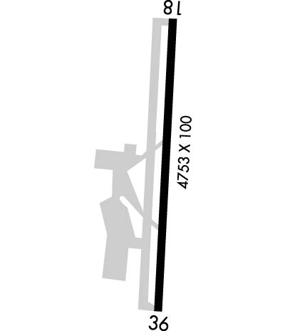
| 4753x100 | 4753' | 4753x100 | 4753' | |||||
| Runway ID | Single Wheel | Double Wheel | Double Tandem Wheel | Dual Double Wheel |
| 18/36 | 30,000 | N/A | N/A | N/A |
| These numbers are Advisory and are not limits. The Airport Manager should have more accurate Weight Limits | ||||
 Airport Diagram might not be current. | |
| Facility Name: | MURFREESBORO MUNI |
| City Name: | MURFREESBORO |
| County: | RUTHERFORD |
| State abbrev: | TN |
| State Name: | TENNESSEE |
| Ownership: | PUBLICLY OWNED |
| Use: | OPEN TO THE PUBLIC |
| Owner's Name: | CITY OF MURFREESBORO |
| Address: | CITY HALL, 111 W VINE ST. |
| MURFREESBORO, TN 37130 | |
| Owner's Phone: | 615-893-5210 |
| Manager's Name: | CHAD GEHRKE |
| Address: | 1930 MEMORIAL BLVD. |
| MURFREESBORO, TN 37129 | |
| Phone: | 615-849-6031 |
| FAA Region: | SOUTHERN |
| FAA Field Office: | MEM |
| Date | Sunrise | Sunset |
|---|---|---|
| 09/24/21 Friday | 6:35 | 18:40 |
| 09/25/21 Saturday | 6:36 | 18:38 |
| 09/26/21 Sunday | 6:36 | 18:37 |
| 09/27/21 Monday | 6:37 | 18:35 |
| 09/28/21 Tuesday | 6:38 | 18:34 |
| 09/29/21 Wednesday | 6:39 | 18:32 |
| 09/30/21 Thursday | 6:40 | 18:31 |
| 10/01/21 Friday | 6:40 | 18:30 |
| 10/02/21 Saturday | 6:41 | 18:28 |
| 10/03/21 Sunday | 6:42 | 18:27 |
| 10/04/21 Monday | 6:43 | 18:25 |
| 10/05/21 Tuesday | 6:44 | 18:24 |
| 10/06/21 Wednesday | 6:44 | 18:22 |
| 10/07/21 Thursday | 6:45 | 18:21 |
| Airport Attendance Schedule | SUN 0900-1830, MON-SAT 0730-1830; GEN ARPT INFO 615-848-3254; FOR EMERG OR AFT HRS SVC 615-849-6031. |
| Airport Status | OPERATIONAL (This Status can change at any time - please check NOTAMS) |
| Airport Lighting Schedule | SS-SR |
| Airport Storage Available | Tie Downs, Hanger |
| Extra Services Available | Air Freight, Avionics, Charter, Flight Instruction, Aircraft Rental, Aircraft Sales |
| Wind Indicator | YES - (lighted) |
| Control Tower | NO |
| CTAF Frequency | 123.075 |
| Unicom Frequency | 123.075 |
| Rotating Beacon Color | CLEAR-GREEN (Light Land Airport) |
| Segmented Circle | YES |
| Landing Fee | NO |
| Airport Inspected | STATE - performed by STATE AERONAUTICAL PERSONNEL |
| Inspection Date | 06/04/2019 |
| Type of Fuel Available | Grade 100LL, JET A |
| Airframe Repair Service | MAJOR |
| Power Plant Repair Service | MAJOR |
| Latitude | N3552.7 |
| Longitude | W08622.6 (ESTIMATED) |
| Arpt Elevation | 614ft (SURVEYED) |
| Magnetic Variation | 02W |
| 2 miles N | of MURFREESBORO |
| Traffic Pattern Altitude | |
| Sectional Chart | ATLANTA |
| Operations (Reported) | Yearly | Avg. Daily |
|---|---|---|
| General Aviation Transient | 3600 | 10 |
| General Aviation Local | 75000 | 205 |
| Air Taxi | 2000 | 5 |
| Commerical | 0 | 0 |
| Commuter | 0 | 0 |
| Military | 100 | 0 |
| Aircraft based on Field | |
|---|---|
| General Aviation Singles | 111 |
| General Aviation Multi | 18 |
| Jet Aircraft | 3 |
| General Aviation Helicopters | 1 |
| Military Aircraft | 0 |
| Gliders | 0 |
| Ultralights | 0 |
| FSS on field | NO |
| FSS tie-in | NASHVILLE |
| FSS Phone | 1-800-WX-BRIEF |
| Who issues Notams | BNA |
| Notam D service at airport | YES |
| ARTCC Name | MEMPHIS |
| Airport Certification | |
| Aircraft Rescue & Firefighting Index | None |
| Airport of Entry | No |
| Custom Landing Rights | No |
| Joint Civil/Military | No |
| Military Landing rights | YES |
| NATIONAL PLAN OF INTEGRATED AIRPORT SYSTEMS (NPIAS) |
| GRANT AGREEMENTS UNDER FAAP/ADAP/AIP |
| ASSURANCES PURSUANT TO TITLE VI, CIVIL RIGHTS ACT OF 1964 |
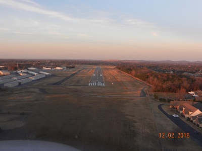
| EXTENSIVE STUDENT FLIGHT TRNG 0800-1700. STD TFC PATTERN REQ OF ALL ACFT. |
| GCO AVBL ON FREQ 135.075 THRU NASHVILLE CD. IF UNA FOR CD CTC NASHVILLE APCH 615-695-4522. |
| WILDLIFE IN VCNTY OF & ARND ARPT. |
| ACFT ENGINE RUN-UPS CONDUCTED E SIDE OF MAIN RAMP. |
| RWY 36 CALM WIND RWY. |
Airport Communications & Frequencies:
| ||||||||||||||
| Runway: 18 | Runway: 36 | ||
| Mag heading: | 184° | Mag heading: | 4° |
| Rwy Slope: | .29% Up | Rwy Slope: | -.29% Down |
| Approach: | Approach: | ||
| Pattern: | Left Traffic | Pattern: | Left Traffic |
| Markings: | NONPRECISION INSTRUMENT | Markings: | NONPRECISION INSTRUMENT |
| Marking Condition: | GOOD | Marking Condition: | GOOD |
| Arresting Dev: | Arresting Dev: | ||
| Lat & Long: | N3553.1 W08622.6 | Lat. & Long.: | N3552.3 W08622.7 |
| Elev: | 600.0 ft. MSL | Elev: | 613.6 ft. MSL |
| TCH: | 18 ft. AGL | TCH: | 25 ft. AGL |
| Visual Glide Path: | 3.00 degrees | Visual Glide Path: | 3.75 degrees |
| Displaced Threshold: | No | Displaced Threshold: | No |
| Touchdown Zone: | YES | Touchdown Zone: | YES |
| Touchdown Elev.: | 609.0 feet | Touchdown Elev.: | 614.1 feet |
| Visual Glide Slope: | 2-Light PAPI on LEFT side of Runway | Visual Glide Slope: | 2-Light PAPI on LEFT side of Runway |
| RVR Equipment: | RVR Equipment: | ||
| RVV Equipment: | NO | RVV Equipment: | NO |
| Approach Lights: | Approach Lights: | ||
| REIL: | YES | REIL: | YES |
| Centerline Lights: | NO | Centerline Lights: | NO |
| Touchdown lights: | NO | Touchdown lights: | NO |
| Runway Category: | Runway with a Non-precision Approach having visibility minimums greater than 3/4 mile | Runway Category: | Runway with a Non-precision Approach having visibility minimums greater than 3/4 mile |
| Declared Distances: | Declared Distances: | ||
| Obstructions: | TREE | Obstructions: | TREE |
| Marked: | NOT Marked/Lighted | Marked: | NOT Marked/Lighted |
| Clearance slope: | 30:1 | Clearance slope: | 17:1 |
| Obstruction height: | 58 feet AGL | Obstruction height: | 92 feet AGL |
| Dist. from runway: | 1955 feet | Dist. from runway: | 1808 feet |
| Centerline offset: | 277 right of centerline | Centerline offset: | 116 feet left of centerline |
| Comments: | Comments: |
Thanks for using FltPlan.com
all rights reserved © 1999-2021 by Flight Plan LLC