| TURKS & CAICOS ISLANDS PROVIDENCIALES |
| |
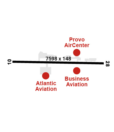
| Lat: N 2146.4 Long: W 07216.0 Elev: 13 Var: +10 Longest Runway: 7598 | ||
| Clr Del: GIVE FP 2 TWR Dept. ATIS: 132.45 Arr. ATIS: 132.45 Ground: 121.9 Tower: 119.9 | ||
| |||||||||||||||||||||||||||||||||||||||||||||||||||||||||||||||||||||
| |||||||||||||||||||||||||||||||||||||||||||||||||||||||||||||||||||||
| |||||||||||||||||||||||||||||||||||||||||||||||||||||||||||||||||||||
| |||||||||||||||||||||||||||||||||||||||||||||||||||||||||||||||||||||
| |||||||||||||||||||||||||||||||||||||||||||||||||||||||||||||||||||||
| |||||||||||||||||||||||||||||||||||||||||||||||||||||||||||||||||||||
| |||||||||||||||||||||||||||||||||||||||||||||||||||||||||||||||||||||
| Rwy | Rwy | |||||||
| 7598x148 | 7598' | 7598x148 | 7598' | |||||
| Runway ID | Single Wheel | Double Wheel | Double Tandem Wheel | Dual Double Wheel |
| 10/28 | N/A | N/A | N/A | N/A |
| These numbers are Advisory and are not limits. The Airport Manager should have more accurate Weight Limits | ||||
| FltPlan does not have IFR approach charts available for MBPV. |
 Airport Diagram might not be current. | |
| Facility Name: | PROVIDENCIALES INTL |
| City Name: | PROVIDENCIALES |
| County: | TURKS AND CAICOS |
| State abbrev: | |
| State Name: | |
| Ownership: | PUBLICLY OWNED |
| Use: | OPEN TO THE PUBLIC; FOREIGN CIV GOVT. LNDG FEES AND DIPLOMATIC CLNC MAY BE RQR. |
| Owner's Name: | |
| Address: | |
| Owner's Phone: | |
| Manager's Name: | AERODROME ADMINISTRATOR |
| Address: | |
| Phone: | 1-800-649-946-2137 |
| FAA Region: | |
| FAA Field Office: | NONE |
| Date | Sunrise | Sunset |
|---|---|---|
| 06/08/26 Monday | 6:05 | 19:31 |
| 06/09/26 Tuesday | 6:05 | 19:31 |
| 06/10/26 Wednesday | 6:05 | 19:32 |
| 06/11/26 Thursday | 6:05 | 19:32 |
| 06/12/26 Friday | 6:06 | 19:32 |
| 06/13/26 Saturday | 6:06 | 19:33 |
| 06/14/26 Sunday | 6:06 | 19:33 |
| 06/15/26 Monday | 6:06 | 19:33 |
| 06/16/26 Tuesday | 6:06 | 19:33 |
| 06/17/26 Wednesday | 6:06 | 19:34 |
| 06/18/26 Thursday | 6:06 | 19:34 |
| 06/19/26 Friday | 6:06 | 19:34 |
| 06/20/26 Saturday | 6:07 | 19:34 |
| 06/21/26 Sunday | 6:07 | 19:35 |
| Airport Attendance Schedule | 7 Days A Week 1100-0100Z++ UTC-5(-4DT). OTR HRS ON REQ |
| Airport Status | OPERATIONAL (This Status can change at any time - please check NOTAMS) |
| Airport Lighting Schedule | AS RQR |
| Airport Storage Available | NONE |
| Extra Services Available | Cargo Handling |
| Wind Indicator | NONE |
| Control Tower | YES |
| CTAF Frequency | |
| Unicom Frequency | |
| Rotating Beacon Color | WG |
| Segmented Circle | NO |
| Landing Fee |
| Airport Inspected | No Inspection Data Available performed by the OWNER |
| Inspection Date | Unknown |
| Type of Fuel Available | Grade 100, JET A (freeze point -40C) |
| Airframe Repair Service | None |
| Power Plant Repair Service | None |
| Latitude | N2146.4 |
| Longitude | W07216.0 (ESTIMATED) |
| Arpt Elevation | 13ft (ESTIMATED) |
| Magnetic Variation | 10W |
| 1 miles N | of PROVIDENCIALES |
| Traffic Pattern Altitude | |
| Sectional Chart |
| Operations (Reported) | Yearly | Avg. Daily |
|---|---|---|
| General Aviation Transient | 0 | 0 |
| General Aviation Local | 0 | 0 |
| Air Taxi | 0 | 0 |
| Commerical | 0 | 0 |
| Commuter | 0 | 0 |
| Military | 0 | 0 |
| Aircraft based on Field | |
|---|---|
| General Aviation Singles | 0 |
| General Aviation Multi | 0 |
| Jet Aircraft | 0 |
| General Aviation Helicopters | 0 |
| Military Aircraft | 0 |
| Gliders | 0 |
| Ultralights | 0 |
| FSS on field | NO |
| FSS tie-in | MIAMI; LCL AIS BRF ON ARPT ALL MONTHS, ALL DAYS, 1100-0100Z++ UTC-5(-4DT). OTR HRS ON REQ. |
| FSS Phone | 1-800-WX-BRIEF |
| Who issues Notams | |
| Notam D service at airport | No |
| ARTCC Name | MIAMI |
| Airport Certification | |
| Aircraft Rescue & Firefighting Index | None |
| Airport of Entry | No |
| Custom Landing Rights | No |
| Joint Civil/Military | No |
| Military Landing rights | No |
| BIRD AND ANIMAL HAZ. |
| FIREFIGHT EQUIP: THREE FOAM TENDERS, EACH 7,585 GALS WATER, 271 GALS FOAM, 1,488 LBS DRY CHEM AVBL. |
Airport Communications & Frequencies:
| |||||||||||||
| Runway: 10 | Runway: 28 | ||
| Mag heading: | 103° | Mag heading: | 283° |
| Rwy Slope: | -.13% Down | Rwy Slope: | .13% Up |
| Approach: | Approach: | ||
| Pattern: | Left Traffic | Pattern: | Left Traffic |
| Markings: | Markings: | ||
| Marking Condition: | Marking Condition: | ||
| Arresting Dev: | Arresting Dev: | ||
| Lat & Long: | N2146.4 W07216.6 | Lat. & Long.: | N2146.4 W07215.3 |
| Elev: | 13.0 ft. MSL | Elev: | 3.0 ft. MSL |
| TCH: | TCH: | ||
| Visual Glide Path: | 3.00 degrees | Visual Glide Path: | 3.00 degrees |
| Displaced Threshold: | No | Displaced Threshold: | No |
| Touchdown Zone: | YES | Touchdown Zone: | YES |
| Touchdown Elev.: | 13.0 feet | Touchdown Elev.: | 3.0 feet |
| Visual Glide Slope: | PAPI ON LEFT. | Visual Glide Slope: | PAPI ON LEFT. |
| RVR Equipment: | RVR Equipment: | ||
| RVV Equipment: | NO | RVV Equipment: | NO |
| Approach Lights: | Approach Lights: | ||
| REIL: | NO | REIL: | NO |
| Centerline Lights: | NO | Centerline Lights: | NO |
| Touchdown lights: | NO | Touchdown lights: | NO |
| Runway Category: | Runway Category: | ||
| Declared Distances: | LDA:9206' | Declared Distances: | LDA:9206' |
Thanks for using FltPlan.com
all rights reserved © 1999-2026 by Flight Plan LLC