
| MALDEN RGNL MALDEN MO |
| |
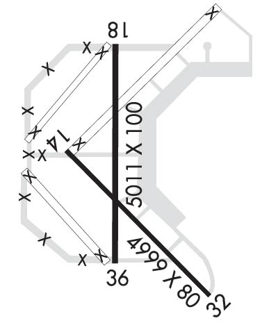
| Lat: N 3635.9 Long: W 08959.6 Elev: 295 Var: +01 Longest Runway: 5010 | ||
| AWOS: 119.82 CTAF: 122.8 | ||
| ||||||||||||||||||||||||||||||||||||||||||||
| ||||||||||||||||||||||||||||||||||||||||||||
| ||||||||||||||||||||||||||||||||||||||||||||
| Rwy | Rwy | |||||||
| 5001x80 | 5001' | 5001x80 | 5001' | |||||
| 5010x100 | 5010' | 5010x100 | 5010' | |||||
| Runway ID | Single Wheel | Double Wheel | Double Tandem Wheel | Dual Double Wheel |
| 14/32 | 33,000 | 48,000 | N/A | N/A |
| 18/36 | 33,000 | 48,000 | N/A | N/A |
| These numbers are Advisory and are not limits. The Airport Manager should have more accurate Weight Limits | ||||
 Airport Diagram might not be current. | |
| Facility Name: | MALDEN RGNL |
| City Name: | MALDEN |
| County: | DUNKLIN |
| State abbrev: | MO |
| State Name: | MISSOURI |
| Ownership: | PUBLICLY OWNED |
| Use: | OPEN TO THE PUBLIC |
| Owner's Name: | CITY OF MALDEN |
| Address: | 201 S. MADISON |
| MALDEN, MO 63863 | |
| Owner's Phone: | 573-276-4502 |
| Manager's Name: | DAVID BLALOCK |
| Address: | PO BOX 411 |
| MALDEN, MO 63863 | |
| Phone: | 573-276-2279; FBO PHONE (573)-776-4406 EMERGENCY CONTACT (573)-281-0059 |
| FAA Region: | CENTRAL |
| FAA Field Office: | NONE |

| Date | Sunrise | Sunset |
|---|---|---|
| 06/08/26 Monday | 5:41 | 20:17 |
| 06/09/26 Tuesday | 5:41 | 20:17 |
| 06/10/26 Wednesday | 5:41 | 20:18 |
| 06/11/26 Thursday | 5:41 | 20:18 |
| 06/12/26 Friday | 5:41 | 20:19 |
| 06/13/26 Saturday | 5:41 | 20:19 |
| 06/14/26 Sunday | 5:41 | 20:20 |
| 06/15/26 Monday | 5:41 | 20:20 |
| 06/16/26 Tuesday | 5:41 | 20:20 |
| 06/17/26 Wednesday | 5:41 | 20:21 |
| 06/18/26 Thursday | 5:41 | 20:21 |
| 06/19/26 Friday | 5:41 | 20:21 |
| 06/20/26 Saturday | 5:42 | 20:21 |
| 06/21/26 Sunday | 5:42 | 20:22 |
| Airport Attendance Schedule | MON-FRI 0800-1700 |
| Airport Status | OPERATIONAL (This Status can change at any time - please check NOTAMS) |
| Airport Lighting Schedule | ACTVT REIL RWY 14/32 & 18/36; PAPI RWY 18, 36 & 32; MIRL RWYS 14/32 & 18/36 - CTAF. |
| Airport Storage Available | Tie Downs, Hanger |
| Extra Services Available | NONE |
| Wind Indicator | YES - (lighted) |
| Control Tower | NO |
| CTAF Frequency | 122.800 |
| Unicom Frequency | 122.800 |
| Rotating Beacon Color | WG |
| Segmented Circle | YES |
| Landing Fee | NO |
| Airport Inspected | STATE - performed by STATE AERONAUTICAL PERSONNEL |
| Inspection Date | 05/16/2023 |
| Type of Fuel Available | Grade 100LL, JET A-1 (icing inhibitor, freeze point -50C); -A1REGULAR AND AFTER HOURS, CALL IN ADVANCE FOR JET A1 573-776-4406 |
| Airframe Repair Service | MINOR |
| Power Plant Repair Service | MINOR |
| Latitude | N3635.9 |
| Longitude | W08959.6 (ESTIMATED) |
| Arpt Elevation | 295ft (SURVEYED) |
| Magnetic Variation | 01W |
| 3 miles N | of MALDEN |
| Traffic Pattern Altitude | |
| Sectional Chart | ST LOUIS |
| Operations (Reported) | Yearly | Avg. Daily |
|---|---|---|
| General Aviation Transient | 0 | 0 |
| General Aviation Local | 0 | 0 |
| Air Taxi | 0 | 0 |
| Commerical | 0 | 0 |
| Commuter | 0 | 0 |
| Military | 0 | 0 |
| Aircraft based on Field | |
|---|---|
| General Aviation Singles | 0 |
| General Aviation Multi | 0 |
| Jet Aircraft | 0 |
| General Aviation Helicopters | 0 |
| Military Aircraft | 0 |
| Gliders | 0 |
| Ultralights | 0 |
| FSS on field | NO |
| FSS tie-in | SAINT LOUIS |
| FSS Phone | 1-800-WX-BRIEF |
| Who issues Notams | STL |
| Notam D service at airport | YES |
| ARTCC Name | MEMPHIS |
| Airport Certification | |
| Aircraft Rescue & Firefighting Index | None |
| Airport of Entry | No |
| Custom Landing Rights | No |
| Joint Civil/Military | No |
| Military Landing rights | YES |
| NATIONAL PLAN OF INTEGRATED AIRPORT SYSTEMS (NPIAS) |
| GRANT AGREEMENTS UNDER FAAP/ADAP/AIP |
| SURPLUS PROPERTY AGREEMENT UNDER PUBLIC LAW 289 |
| ASSURANCES PURSUANT TO TITLE VI, CIVIL RIGHTS ACT OF 1964 |
| CROP DUSTING ACFT ON & INVOF ARPT. |
| FOR CD IF UNA VIA GCO CTC MEMPHIS ARTCC AT 901-368-8453/8449. |
| IRRIGATION SYSTEM MAY BE OPERATING WITHIN 300 FT OF RY 18 AND RY 32 ENDS AND SIDES. |
| A/G TEST FLYING. |
| 24 HR ACCESS TO PILOTS LOUNGE. ENTER UNICOM ON LOCK FOR ACCESS. |
| GCO AVBL ON FREQ 135.075 4 CLICKS TO MEMPHIS CENTER AND 6 CLICKS TO FSS . |
| PERM AEROBATIC PRACTICE BOX SFC - 5,000 FT, WEST OF RWYS. |
Airport Communications & Frequencies:
| |||||||||
| Runway: 14 | Runway: 32 | ||
| Mag heading: | 137° | Mag heading: | 317° |
| Rwy Slope: | -.03% Down | Rwy Slope: | .03% Up |
| Approach: | Approach: | ||
| Pattern: | Right Traffic | Pattern: | Left Traffic |
| Markings: | NONPRECISION INSTRUMENT | Markings: | NONPRECISION INSTRUMENT |
| Marking Condition: | GOOD | Marking Condition: | GOOD |
| Arresting Dev: | Arresting Dev: | ||
| Lat & Long: | N3636.0 W08959.9 | Lat. & Long.: | N3635.5 W08959.1 |
| Elev: | 292.9 ft. MSL | Elev: | 291.2 ft. MSL |
| TCH: | TCH: | 41 ft. AGL | |
| Visual Glide Path: | Visual Glide Path: | 3.00 degrees | |
| Displaced Threshold: | No | Displaced Threshold: | No |
| Touchdown Zone: | YES | Touchdown Zone: | YES |
| Touchdown Elev.: | 293.8 feet | Touchdown Elev.: | 293.2 feet |
| Visual Glide Slope: | Visual Glide Slope: | 4-Light PAPI on RIGHT side of Runway | |
| RVR Equipment: | RVR Equipment: | ||
| RVV Equipment: | NO | RVV Equipment: | NO |
| Approach Lights: | Approach Lights: | ||
| REIL: | YES | REIL: | YES; REIL OTS INDEFINITELY. |
| Centerline Lights: | NO | Centerline Lights: | NO |
| Touchdown lights: | NO | Touchdown lights: | NO |
| Runway Category: | Runway with a Non-precision Approach having visibility minimums greater than 3/4 mile | Runway Category: | Runway with a Non-precision Approach having visibility minimums greater than 3/4 mile |
| Declared Distances: | Declared Distances: |
| Runway: 18 | Runway: 36 | ||
| Mag heading: | 182° | Mag heading: | 2° |
| Rwy Slope: | -.05% Down | Rwy Slope: | .05% Up |
| Approach: | Approach: | ||
| Pattern: | Right Traffic | Pattern: | Left Traffic |
| Markings: | NONPRECISION INSTRUMENT | Markings: | NONPRECISION INSTRUMENT |
| Marking Condition: | FAIR | Marking Condition: | FAIR |
| Arresting Dev: | Arresting Dev: | ||
| Lat & Long: | N3636.4 W08959.6 | Lat. & Long.: | N3635.6 W08959.6 |
| Elev: | 294.6 ft. MSL | Elev: | 292.1 ft. MSL |
| TCH: | 42 ft. AGL | TCH: | 42 ft. AGL |
| Visual Glide Path: | 3.00 degrees | Visual Glide Path: | 3.00 degrees |
| Displaced Threshold: | No | Displaced Threshold: | No |
| Touchdown Zone: | YES | Touchdown Zone: | YES |
| Touchdown Elev.: | 295.3 feet | Touchdown Elev.: | 295.3 feet |
| Visual Glide Slope: | 4-Light PAPI on LEFT side of Runway | Visual Glide Slope: | 4-Light PAPI on RIGHT side of Runway |
| RVR Equipment: | RVR Equipment: | ||
| RVV Equipment: | NO | RVV Equipment: | NO |
| Approach Lights: | Approach Lights: | ||
| REIL: | YES | REIL: | YES |
| Centerline Lights: | NO | Centerline Lights: | NO |
| Touchdown lights: | NO | Touchdown lights: | NO |
| Runway Category: | Runway with a Non-precision Approach having visibility minimums greater than 3/4 mile | Runway Category: | Runway with a Non-precision Approach having visibility minimums greater than 3/4 mile |
| Declared Distances: | Declared Distances: |
Thanks for using FltPlan.com
all rights reserved © 1999-2026 by Flight Plan LLC