
| MALONE-DUFORT MALONE NY |
| |
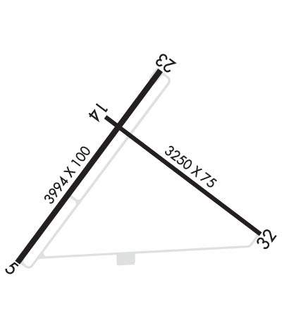
| Lat: N 4451.2 Long: W 07419.7 Elev: 790 Var: +15 Longest Runway: 3994 | ||
| CTAF: 122.8 | ||
| ||||||||||||||||||||||||||||||||
| ||||||||||||||||||||||||||||||||
| Rwy | Rwy | |||||||
| 3994x100 | 3994' | 3994x100 | 3994' | |||||
| 3250x75 | 3250' | 3250x75 | 2902' | |||||
| Runway ID | Single Wheel | Double Wheel | Double Tandem Wheel | Dual Double Wheel |
| 05/23 | 20,000 | N/A | N/A | N/A |
| 14/32 | 12,500 | N/A | N/A | N/A |
| These numbers are Advisory and are not limits. The Airport Manager should have more accurate Weight Limits | ||||
 Airport Diagram might not be current. | |
| Facility Name: | MALONE-DUFORT |
| City Name: | MALONE |
| County: | FRANKLIN |
| State abbrev: | NY |
| State Name: | NEW YORK |
| Ownership: | PUBLICLY OWNED |
| Use: | OPEN TO THE PUBLIC |
| Owner's Name: | TOWN OF MALONE |
| Address: | 27 AIRPORT ROAD |
| MALONE, NY 12953 | |
| Owner's Phone: | (518) 483-4740 |
| Manager's Name: | BRUCE BURDITT |
| Address: | 27 AIRPORT ROAD |
| MALONE, NY 12953 | |
| Phone: | (518) 483-4740 |
| FAA Region: | EASTERN |
| FAA Field Office: | NYC |
| Date | Sunrise | Sunset |
|---|---|---|
| 06/12/26 Friday | 5:11 | 20:44 |
| 06/13/26 Saturday | 5:11 | 20:44 |
| 06/14/26 Sunday | 5:11 | 20:45 |
| 06/15/26 Monday | 5:10 | 20:45 |
| 06/16/26 Tuesday | 5:10 | 20:46 |
| 06/17/26 Wednesday | 5:11 | 20:46 |
| 06/18/26 Thursday | 5:11 | 20:46 |
| 06/19/26 Friday | 5:11 | 20:47 |
| 06/20/26 Saturday | 5:11 | 20:47 |
| 06/21/26 Sunday | 5:11 | 20:47 |
| 06/22/26 Monday | 5:11 | 20:47 |
| 06/23/26 Tuesday | 5:12 | 20:47 |
| 06/24/26 Wednesday | 5:12 | 20:47 |
| 06/25/26 Thursday | 5:12 | 20:48 |
| Airport Attendance Schedule | |
| Airport Status | OPERATIONAL (This Status can change at any time - please check NOTAMS) |
| Airport Lighting Schedule | ACTVT PAPI RWY 05 & 23, MIRL RWY 05/23, 14/32 & TWY LGTS - CTAF. |
| Airport Storage Available | Tie Downs |
| Extra Services Available | NONE |
| Wind Indicator | YES - (lighted) |
| Control Tower | NO |
| CTAF Frequency | 122.800 |
| Unicom Frequency | 122.800 |
| Rotating Beacon Color | WG |
| Segmented Circle | YES |
| Landing Fee | NO |
| Airport Inspected | STATE - performed by STATE AERONAUTICAL PERSONNEL |
| Inspection Date | 05/18/2026 |
| Type of Fuel Available | Grade 100LL |
| Airframe Repair Service | NONE |
| Power Plant Repair Service | NONE |
| Latitude | N4451.2 |
| Longitude | W07419.7 (ESTIMATED) |
| Arpt Elevation | 789ft (SURVEYED) |
| Magnetic Variation | 15W |
| 2 miles W | of MALONE |
| Traffic Pattern Altitude | |
| Sectional Chart | MONTREAL |
| Operations (Reported) | Yearly | Avg. Daily |
|---|---|---|
| General Aviation Transient | 0 | 0 |
| General Aviation Local | 0 | 0 |
| Air Taxi | 0 | 0 |
| Commerical | 0 | 0 |
| Commuter | 0 | 0 |
| Military | 0 | 0 |
| Aircraft based on Field | |
|---|---|
| General Aviation Singles | 0 |
| General Aviation Multi | 0 |
| Jet Aircraft | 0 |
| General Aviation Helicopters | 0 |
| Military Aircraft | 0 |
| Gliders | 0 |
| Ultralights | 0 |
| FSS on field | NO |
| FSS tie-in | BURLINGTON |
| FSS Phone | 1-800-WX-BRIEF |
| Who issues Notams | BTV |
| Notam D service at airport | YES |
| ARTCC Name | BOSTON |
| Airport Certification | |
| Aircraft Rescue & Firefighting Index | None |
| Airport of Entry | No |
| Custom Landing Rights | No |
| Joint Civil/Military | No |
| Military Landing rights | YES |
| NATIONAL PLAN OF INTEGRATED AIRPORT SYSTEMS (NPIAS) |
| GRANT AGREEMENTS UNDER FAAP/ADAP/AIP |
| ASSURANCES PURSUANT TO TITLE VI, CIVIL RIGHTS ACT OF 1964 |
| GRANT AGREEMENT HAS EXPIRED; HOWEVER, AGREEMENT REMAINS IN EFFECT FOR THIS FACILITY AS LONG AS IT IS PUBLIC USE. |
| AGREEMENT UNDER DLAND OR DCLA HAS EXPIRED. |
| HAYING ACTIVITY & EQUIPMENT PRESENT JUN - SEP. |
| RY 14/32 HAS SNOW REMOVAL BUT VISUAL INSPECTION & NOTAM CHECK MUST BE DONE AS TOWN ROADS ARE PLOWED BEFORE ARPT. |
| FOR CD CTC BOSTON ARTCC AT 603-879-6859. |
| AIRPORT NOT ATTENDED |
Airport Communications & Frequencies:
| |||||||||
| Runway: 05 | Runway: 23 | ||
| Mag heading: | 52° | Mag heading: | 232° |
| Rwy Slope: | -.41% Down | Rwy Slope: | .41% Up |
| Approach: | Approach: | ||
| Pattern: | Left Traffic | Pattern: | Left Traffic |
| Markings: | NONPRECISION INSTRUMENT | Markings: | NONPRECISION INSTRUMENT |
| Marking Condition: | GOOD | Marking Condition: | GOOD |
| Arresting Dev: | Arresting Dev: | ||
| Lat & Long: | N4451.0 W07420.2 | Lat. & Long.: | N4451.5 W07419.6 |
| Elev: | 770.7 ft. MSL | Elev: | 754.4 ft. MSL |
| TCH: | 42 ft. AGL | TCH: | 43 ft. AGL |
| Visual Glide Path: | 3.15 degrees | Visual Glide Path: | 3.00 degrees |
| Displaced Threshold: | No | Displaced Threshold: | No |
| Touchdown Zone: | YES | Touchdown Zone: | YES |
| Touchdown Elev.: | 770.7 feet | Touchdown Elev.: | 769.5 feet |
| Visual Glide Slope: | 2-Light PAPI on LEFT side of Runway | Visual Glide Slope: | 2-Light PAPI on LEFT side of Runway |
| RVR Equipment: | RVR Equipment: | ||
| RVV Equipment: | NO | RVV Equipment: | NO |
| Approach Lights: | Approach Lights: | ||
| REIL: | YES | REIL: | YES |
| Centerline Lights: | NO | Centerline Lights: | NO |
| Touchdown lights: | NO | Touchdown lights: | NO |
| Runway Category: | Runway with a Non-precision Approach | Runway Category: | Runway with a Non-precision Approach |
| Declared Distances: | TORA:3994' TODA:3994' ASDA:3994' LDA:3994' | Declared Distances: | TORA:3994' TODA:3994' ASDA:3994' LDA:3994' |
| Obstructions: | TREES | Obstructions: | TREES |
| Marked: | NOT Marked/Lighted | Marked: | NOT Marked/Lighted |
| Clearance slope: | 3:1 | Clearance slope: | 9:1 |
| Obstruction height: | 16 feet AGL | Obstruction height: | 52 feet AGL |
| Dist. from runway: | 262 feet | Dist. from runway: | 696 feet |
| Centerline offset: | 172 right of centerline | Centerline offset: | 322 feet right of centerline |
| Comments: | Comments: |
| Runway: 14 | Runway: 32 | ||
| Mag heading: | 142° | Mag heading: | 322° |
| Rwy Slope: | .94% Up | Rwy Slope: | -.94% Down |
| Approach: | Approach: | ||
| Pattern: | Left Traffic | Pattern: | Left Traffic |
| Markings: | BASIC | Markings: | BASIC |
| Marking Condition: | GOOD | Marking Condition: | FAIR |
| Arresting Dev: | Arresting Dev: | ||
| Lat & Long: | N4451.4 W07419.8 | Lat. & Long.: | N4451.0 W07419.2 |
| Elev: | 759.5 ft. MSL | Elev: | 789.9 ft. MSL |
| TCH: | TCH: | ||
| Visual Glide Path: | Visual Glide Path: | ||
| Displaced Threshold: | No | Displaced Threshold: | 348 feet |
| Touchdown Zone: | YES | Touchdown Zone: | YES |
| Touchdown Elev.: | 788.1 feet | Touchdown Elev.: | 787.2 feet |
| Visual Glide Slope: | Visual Glide Slope: | ||
| RVR Equipment: | RVR Equipment: | ||
| RVV Equipment: | NO | RVV Equipment: | NO |
| Approach Lights: | Approach Lights: | ||
| REIL: | NO | REIL: | NO |
| Centerline Lights: | NO | Centerline Lights: | NO |
| Touchdown lights: | NO | Touchdown lights: | NO |
| Runway Category: | Runway with a Visual Approach | Runway Category: | Runway with a Visual Approach |
| Declared Distances: | TORA:3250' TODA:3250' ASDA:3250' LDA:3250' | Declared Distances: | TORA:3250' TODA:3250' ASDA:3250' LDA:2902' |
| Obstructions: | TREES | Obstructions: | TREE |
| Marked: | NOT Marked/Lighted | Marked: | NOT Marked/Lighted |
| Clearance slope: | 20:1 | Clearance slope: | APCH SLOPE 21:1, DUE TO +72 FT BLDG, 1572 FT FM DSPLCD THLD; +38 FT TREES, 805 FT FM DSPLCD THLD. |
| Obstruction height: | 30 feet AGL | Obstruction height: | 34 feet AGL |
| Dist. from runway: | 815 feet | Dist. from runway: | 203 feet |
| Centerline offset: | 144 left of centerline | Centerline offset: | 85 feet right of centerline |
| Comments: | Comments: |
Thanks for using FltPlan.com
all rights reserved © 1999-2026 by Flight Plan LLC
