
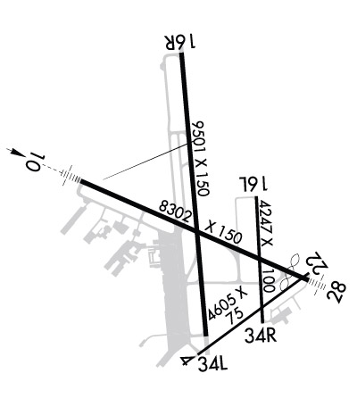
| MIDLAND INTL MIDLAND TX |
| |
| Lat: N 3156.6 Long: W 10212.1 Elev: 2872 Var: -09 Longest Runway: 9501 | ||
| Clr Del: 118.05 Dept. ATIS: 126.8 Arr. ATIS: 126.8 AWOS: 126.8 Ground: 121.9 Tower: 118.7 | ||
| ||||||||||||||||||||||||||||||||||||||||||||
| ||||||||||||||||||||||||||||||||||||||||||||
| ||||||||||||||||||||||||||||||||||||||||||||
| Rwy | Rwy | |||||||
| 4605x75 | 4605' | 4605x75 | 4605' | |||||
| 8302x150 | 8302' | 110.30 - 105° | 8302x150 | 7611' | ||||
| 4247x100 | 4247' | 4247x100 | 4247' | |||||
| 9501x150 | 9501' | 9501x150 | 9501' | |||||
| Runway ID | Single Wheel | Double Wheel | Double Tandem Wheel | Dual Double Wheel |
| 04/22 | 30,000 | 60,000 | N/A | N/A |
| 10/28 | 160,000 | 200,000 | 350,000 | 700,000 |
| 16L/34R | 30,000 | 60,000 | N/A | N/A |
| 16R/34L | 160,000 | 200,000 | 350,000 | 700,000 |
| These numbers are Advisory and are not limits. The Airport Manager should have more accurate Weight Limits | ||||
 Airport Diagram might not be current. | |
| Facility Name: | MIDLAND INTL AIR AND SPACE PORT |
| City Name: | MIDLAND |
| County: | MIDLAND |
| State abbrev: | TX |
| State Name: | TEXAS |
| Ownership: | PUBLICLY OWNED |
| Use: | OPEN TO THE PUBLIC |
| Owner's Name: | CITY OF MIDLAND |
| Address: | PO BOX 1152 |
| MIDLAND, TX 79702 | |
| Owner's Phone: | 432-685-7100 |
| Manager's Name: | JUSTINE RUFF |
| Address: | PO BOX 60305 |
| MIDLAND, TX 79711 | |
| Phone: | 432-560-2200 |
| FAA Region: | SOUTHWEST |
| FAA Field Office: | TEX |
| Date | Sunrise | Sunset |
|---|---|---|
| 06/07/26 Sunday | 6:43 | 20:53 |
| 06/08/26 Monday | 6:42 | 20:53 |
| 06/09/26 Tuesday | 6:42 | 20:54 |
| 06/10/26 Wednesday | 6:42 | 20:54 |
| 06/11/26 Thursday | 6:42 | 20:55 |
| 06/12/26 Friday | 6:42 | 20:55 |
| 06/13/26 Saturday | 6:42 | 20:55 |
| 06/14/26 Sunday | 6:42 | 20:56 |
| 06/15/26 Monday | 6:42 | 20:56 |
| 06/16/26 Tuesday | 6:42 | 20:56 |
| 06/17/26 Wednesday | 6:43 | 20:57 |
| 06/18/26 Thursday | 6:43 | 20:57 |
| 06/19/26 Friday | 6:43 | 20:57 |
| 06/20/26 Saturday | 6:43 | 20:58 |
| Airport Attendance Schedule | CONTINUOUS |
| Airport Status | OPERATIONAL (This Status can change at any time - please check NOTAMS) |
| Airport Lighting Schedule | ATC CTL. WHEN ATCT CLSD HIRL RWYS 10/28 & 16R/34L PRESET ON LOW INTST. WHEN ATCT CLSD ACTVT MALSR RWY 10; MALS RWY 28; MIRL RWYS 04/22 & 16L/34R - CTAF. |
| Airport Storage Available | Tie Downs, Hanger |
| Extra Services Available | Air Freight, Air Ambulance, Avionics, Cargo Handling, Charter, Flight Instruction, Aircraft Rental, Aircraft Sales |
| Wind Indicator | YES - (lighted) |
| Control Tower | YES |
| CTAF Frequency | 118.700 |
| Unicom Frequency | 122.950 |
| Rotating Beacon Color | WG |
| Segmented Circle | YES |
| Landing Fee | YES |
| Airport Inspected | FEDERAL - performed by FAA AIRPORTS FIELD PERSONNEL |
| Inspection Date | 05/08/2025 |
| Type of Fuel Available | Grade 100LL, JET A (freeze point -40C), JET A-1 (freeze point -50C) |
| Airframe Repair Service | MAJOR |
| Power Plant Repair Service | MAJOR |
| Latitude | N3156.6 |
| Longitude | W10212.1 (ESTIMATED) |
| Arpt Elevation | 2872ft (SURVEYED) |
| Magnetic Variation | 09E |
| 8 miles SW | of MIDLAND |
| Traffic Pattern Altitude | |
| Sectional Chart | SAN ANTONIO |
| Operations (Reported) | Yearly | Avg. Daily |
|---|---|---|
| General Aviation Transient | 0 | 0 |
| General Aviation Local | 0 | 0 |
| Air Taxi | 0 | 0 |
| Commerical | 0 | 0 |
| Commuter | 0 | 0 |
| Military | 0 | 0 |
| Aircraft based on Field | |
|---|---|
| General Aviation Singles | 0 |
| General Aviation Multi | 0 |
| Jet Aircraft | 0 |
| General Aviation Helicopters | 0 |
| Military Aircraft | 0 |
| Gliders | 0 |
| Ultralights | 0 |
| FSS on field | NO |
| FSS tie-in | SAN ANGELO |
| FSS Phone | 1-800-WX-BRIEF |
| Who issues Notams | MAF |
| Notam D service at airport | YES |
| ARTCC Name | FORT WORTH |
| Airport Certification | AIRPORT RECEIVING SCHEDULED AIR CARRIER SERVICE FROM CARRIERS CERTIFICATED BY THE CIVIL AERONAUTICS BOARD; FOR ARFF SVC BTN 0000-0600 DLY CTC FSS AT 800-992-7433. |
| Aircraft Rescue & Firefighting Index | AIRPORT HAS A CERTIFICATE UNDER CFR PART 139 |
| Airport of Entry | No |
| Custom Landing Rights | No; US CUSTOMS USER FEE ARPT. |
| Joint Civil/Military | No |
| Military Landing rights | YES |
| NATIONAL PLAN OF INTEGRATED AIRPORT SYSTEMS (NPIAS) |
| GRANT AGREEMENTS UNDER FAAP/ADAP/AIP |
| SURPLUS PROPERTY AGREEMENT UNDER PUBLIC LAW 289 |
| ASSURANCES PURSUANT TO TITLE VI, CIVIL RIGHTS ACT OF 1964 |
| THIS AIRPORT HAS BEEN SURVEYED BY THE NATIONAL GEODETIC SURVEY. |
| OPRS ON NON PAVED SFC ARE PROHIBITED WO 24 HR PPR. |
| RWYS 04/22 & 16L/34R CLSD TO ACFT OVER 60000 LBS. |
| TWYS B & F NORTH RWY 10/28 CLSD TO ACFT OVER 60000 LBS. |
| BIRD ACTIVITY ON & INVOF ARPT. |
| NMRS OIL RIGS INVOF ARPT AT OR BLW 200 FT AGL. |
| ALL RUNUP PADS ARE LTD USAGE TO ACFT 60000 LBS OR BLW. |
| FOR CD IF UNA TO CTC ON FSS FREQ, CTC FORT WORTH ARTCC AT 817-858-7584. |
| RWY 04/2 2 RWY 04/22 NOT AVBL FOR PART 121/PART 380 OPS WITH SKED PAX CARRYING OPS MORE THAN 9 PAX SEATS AND NON-SKED PAX CARRYING OPS MORE THAN 30 PAX SEATS. |
| RWY 10/2 8 180 DEG TURN PROHIBITED TO ACFT 60000 LBS OR ABV. |
| RWY 16L/ 34RRWY 16L/34R NOT AVBL FOR PART 121/PART 380 OPS WITH SKED PAX CARRYING OPS MORE THAN 9 PAX SEATS AND NON-SKED PAX CARRYING OPS MORE THAN 30 PAX SEATS. |
| RWY 16R/ 34L180 DEG TURN PROHIBITED TO ACFT 60000 LBS OR ABV. |
| RWY 10/2 8 EAST 692 FT CLSD TO ACFT OVER 60000 LBS. |
| RWY 10/2 8 PCR VALUE: 660/F/B/X/T |
| RWY 16R/ 34LPCR VALUE: 730/F/B/X/T |
Airport Communications & Frequencies:
| |||||||||||||||||||||||||||||||||||||||||||||||||||||
| Runway: 04 | Runway: 22 | ||
| Mag heading: | 45° | Mag heading: | 225° |
| Rwy Slope: | .08% Up | Rwy Slope: | -.08% Down |
| Approach: | Approach: | ||
| Pattern: | Left Traffic | Pattern: | Left Traffic |
| Markings: | NONPRECISION INSTRUMENT | Markings: | NONPRECISION INSTRUMENT |
| Marking Condition: | GOOD | Marking Condition: | GOOD |
| Arresting Dev: | Arresting Dev: | ||
| Lat & Long: | N3155.9 W10212.2 | Lat. & Long.: | N3156.4 W10211.5 |
| Elev: | 2851.3 ft. MSL | Elev: | 2854.9 ft. MSL |
| TCH: | TCH: | ||
| Visual Glide Path: | Visual Glide Path: | ||
| Displaced Threshold: | No | Displaced Threshold: | No |
| Touchdown Zone: | YES | Touchdown Zone: | YES |
| Touchdown Elev.: | 2851.3 feet | Touchdown Elev.: | 2854.9 feet |
| Visual Glide Slope: | Visual Glide Slope: | ||
| RVR Equipment: | RVR Equipment: | ||
| RVV Equipment: | NO | RVV Equipment: | NO |
| Approach Lights: | Approach Lights: | ||
| REIL: | NO | REIL: | NO |
| Centerline Lights: | NO | Centerline Lights: | NO |
| Touchdown lights: | NO | Touchdown lights: | NO |
| Runway Category: | Runway with a Non-precision Approach having visibility minimums greater than 3/4 mile | Runway Category: | Runway with a Non-precision Approach having visibility minimums greater than 3/4 mile |
| Declared Distances: | TORA:4605' TODA:4605' ASDA:4605' LDA:4605' | Declared Distances: | TORA:4605' TODA:4605' ASDA:4605' LDA:4605' |
| Obstructions: | POLE | Obstructions: | ROAD |
| Marked: | NOT Marked/Lighted | Marked: | NOT Marked/Lighted |
| Clearance slope: | 43:1 | Clearance slope: | 49:1 |
| Obstruction height: | 57 feet AGL | Obstruction height: | 23 feet AGL |
| Dist. from runway: | 2688 feet | Dist. from runway: | 1333 feet |
| Centerline offset: | 390 right of centerline | Centerline offset: | 9 feet left of centerline |
| Comments: | Comments: |
| Runway: 10 | Runway: 28 | ||
| Mag heading: | 105° | Mag heading: | 285° |
| Rwy Slope: | -.18% Down | Rwy Slope: | .18% Up |
| Approach: | ILS/DME | Approach: | |
| Pattern: | Left Traffic | Pattern: | Left Traffic |
| Markings: | PRECISION INSTRUMENT | Markings: | PRECISION INSTRUMENT |
| Marking Condition: | GOOD | Marking Condition: | GOOD |
| Arresting Dev: | Arresting Dev: | ||
| Lat & Long: | N3156.9 W10213.0 | Lat. & Long.: | N3156.3 W10211.5 |
| Elev: | 2869.3 ft. MSL | Elev: | 2854.0 ft. MSL |
| TCH: | 54 ft. AGL | TCH: | 53 ft. AGL |
| Visual Glide Path: | 3.00 degrees | Visual Glide Path: | 3.00 degrees |
| Displaced Threshold: | No | Displaced Threshold: | 691 feet |
| Touchdown Zone: | YES | Touchdown Zone: | YES |
| Touchdown Elev.: | 2869.3 feet | Touchdown Elev.: | 2857.6 feet |
| Visual Glide Slope: | 4-Light PAPI on LEFT side of Runway | Visual Glide Slope: | 4-Light PAPI on RIGHT side of Runway |
| RVR Equipment: | TOUCHDOWN | RVR Equipment: | ROLLOUT |
| RVV Equipment: | NO | RVV Equipment: | NO |
| Approach Lights: | MALSR - 1,400 foot medium intensity approach lighting system with runway alignment indicator lights | Approach Lights: | MALS - 1,400 foot medium intensity approach lighting system |
| REIL: | NO | REIL: | NO |
| Centerline Lights: | NO | Centerline Lights: | NO |
| Touchdown lights: | NO | Touchdown lights: | NO |
| Runway Category: | Precision Instrument Runway | Runway Category: | D |
| Declared Distances: | TORA:8302' TODA:8302' ASDA:8177' LDA:8177' | Declared Distances: | TORA:8302' TODA:8302' ASDA:8302' LDA:7610' |
| Runway: 16L | Runway: 34R | ||
| Mag heading: | 168° | Mag heading: | 348° |
| Rwy Slope: | -.39% Down | Rwy Slope: | .39% Up |
| Approach: | Approach: | ||
| Pattern: | Left Traffic | Pattern: | Left Traffic |
| Markings: | BASIC | Markings: | BASIC |
| Marking Condition: | GOOD | Marking Condition: | GOOD |
| Arresting Dev: | Arresting Dev: | ||
| Lat & Long: | N3156.8 W10211.8 | Lat. & Long.: | N3156.1 W10211.8 |
| Elev: | 2864.6 ft. MSL | Elev: | 2847.9 ft. MSL |
| TCH: | TCH: | ||
| Visual Glide Path: | Visual Glide Path: | ||
| Displaced Threshold: | No | Displaced Threshold: | No |
| Touchdown Zone: | YES | Touchdown Zone: | YES |
| Touchdown Elev.: | 2864.6 feet | Touchdown Elev.: | 2856.9 feet |
| Visual Glide Slope: | Visual Glide Slope: | ||
| RVR Equipment: | RVR Equipment: | ||
| RVV Equipment: | NO | RVV Equipment: | NO |
| Approach Lights: | Approach Lights: | ||
| REIL: | NO | REIL: | NO |
| Centerline Lights: | NO | Centerline Lights: | NO |
| Touchdown lights: | NO | Touchdown lights: | NO |
| Runway Category: | Runway with a Visual Approach | Runway Category: | Runway with a Visual Approach |
| Declared Distances: | TORA:4247' TODA:4247' ASDA:4247' LDA:4247' | Declared Distances: | TORA:4247' TODA:4247' ASDA:4247' LDA:4247' |
| Obstructions: | FENCE | Obstructions: | ROAD |
| Marked: | NOT Marked/Lighted | Marked: | NOT Marked/Lighted |
| Clearance slope: | 25:1 | Clearance slope: | 14:1 |
| Obstruction height: | 7 feet AGL | Obstruction height: | 13 feet AGL |
| Dist. from runway: | 375 feet | Dist. from runway: | 390 feet |
| Centerline offset: | 100B | Centerline offset: | 250 feet right of centerline |
| Comments: | Comments: |
| Runway: 16R | Runway: 34L | ||
| Mag heading: | 166° | Mag heading: | 346° |
| Rwy Slope: | -.22% Down | Rwy Slope: | .22% Up |
| Approach: | Approach: | ||
| Pattern: | Left Traffic | Pattern: | Left Traffic |
| Markings: | PRECISION INSTRUMENT | Markings: | PRECISION INSTRUMENT |
| Marking Condition: | GOOD | Marking Condition: | GOOD |
| Arresting Dev: | Arresting Dev: | ||
| Lat & Long: | N3157.6 W10212.3 | Lat. & Long.: | N3156.0 W10212.2 |
| Elev: | 2872.1 ft. MSL | Elev: | 2851.0 ft. MSL |
| TCH: | 50 ft. AGL | TCH: | 50 ft. AGL |
| Visual Glide Path: | 3.00 degrees | Visual Glide Path: | 3.00 degrees |
| Displaced Threshold: | No | Displaced Threshold: | No |
| Touchdown Zone: | YES | Touchdown Zone: | YES |
| Touchdown Elev.: | 2872.1 feet | Touchdown Elev.: | 2858.2 feet |
| Visual Glide Slope: | 4-Light PAPI on LEFT side of Runway | Visual Glide Slope: | 4-Light PAPI on LEFT side of Runway |
| RVR Equipment: | RVR Equipment: | ||
| RVV Equipment: | NO | RVV Equipment: | NO |
| Approach Lights: | Approach Lights: | ||
| REIL: | NO | REIL: | YES |
| Centerline Lights: | NO | Centerline Lights: | NO |
| Touchdown lights: | NO | Touchdown lights: | NO |
| Runway Category: | Runway with a Non-precision Approach having visibility minimums greater than 3/4 mile | Runway Category: | Runway with a Non-precision Approach having visibility minimums greater than 3/4 mile |
| Declared Distances: | TORA:9501' TODA:9501' ASDA:9501' LDA:9501' | Declared Distances: | TORA:9501' TODA:9501' ASDA:9501' LDA:9501' |
| Obstructions: | Obstructions: | POLE | |
| Marked: | Marked: | NOT Marked/Lighted | |
| Clearance slope: | 50:1 | Clearance slope: | 48:1 |
| Obstruction height: | Obstruction height: | 28 feet AGL | |
| Dist. from runway: | Dist. from runway: | 1550 feet | |
| Centerline offset: | Centerline offset: | 300 feet left of centerline | |
| Comments: | Comments: |
Thanks for using FltPlan.com
all rights reserved © 1999-2026 by Flight Plan LLC
