
| MADERA MUNI MADERA CA |
| |
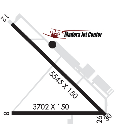
| Lat: N 3659.3 Long: W 12006.7 Elev: 255 Var: -13 Longest Runway: 5545 | ||
| Clr Del: 119.45 AWOS: 134.72 CTAF: 122.8 | ||
| ||||||||||||||||||||||||||||||
| ||||||||||||||||||||||||||||||
| ||||||||||||||||||||||||||||||
| ||||||||||||||||||||||||||||||
| ||||||||||||||||||||||||||||||
| Rwy | Rwy | |||||||
| 5545x150 | 5545' | 5545x150 | 5545' | |||||
| Runway ID | Single Wheel | Double Wheel | Double Tandem Wheel | Dual Double Wheel |
| 12/30 | 30,000 | N/A | N/A | N/A |
| These numbers are Advisory and are not limits. The Airport Manager should have more accurate Weight Limits | ||||
 Airport Diagram might not be current. | |
| Facility Name: | MADERA MUNI |
| City Name: | MADERA |
| County: | MADERA |
| State abbrev: | CA |
| State Name: | CALIFORNIA |
| Ownership: | PUBLICLY OWNED |
| Use: | OPEN TO THE PUBLIC |
| Owner's Name: | CITY OF MADERA |
| Address: | 205 WEST 4TH ST |
| MADERA, CA 93637 | |
| Owner's Phone: | (559) 661-5466 |
| Manager's Name: | ADAM GONZALES; MCHURCH@CITYOFMADERA.COM |
| Address: | 4020 AVIATION DR |
| MADERA, CA 93637 | |
| Phone: | 559-662-4951 |
| FAA Region: | WESTERN-PACIFIC |
| FAA Field Office: | SFO |
| Date | Sunrise | Sunset |
|---|---|---|
| 09/24/21 Friday | 6:50 | 18:55 |
| 09/25/21 Saturday | 6:51 | 18:53 |
| 09/26/21 Sunday | 6:51 | 18:51 |
| 09/27/21 Monday | 6:52 | 18:50 |
| 09/28/21 Tuesday | 6:53 | 18:48 |
| 09/29/21 Wednesday | 6:54 | 18:47 |
| 09/30/21 Thursday | 6:55 | 18:45 |
| 10/01/21 Friday | 6:56 | 18:44 |
| 10/02/21 Saturday | 6:56 | 18:42 |
| 10/03/21 Sunday | 6:57 | 18:41 |
| 10/04/21 Monday | 6:58 | 18:40 |
| 10/05/21 Tuesday | 6:59 | 18:38 |
| 10/06/21 Wednesday | 7:00 | 18:37 |
| 10/07/21 Thursday | 7:01 | 18:35 |
| Airport Attendance Schedule | MON-FRI 0700-1600 |
| Airport Status | OPERATIONAL (This Status can change at any time - please check NOTAMS) |
| Airport Lighting Schedule | ACTVT MIRL RY 12/30; PAPI RYS 12 & 30, REIL RY 12, MALSF RY 30 AND WIND TEE - CTAF. |
| Airport Storage Available | Tie Downs |
| Extra Services Available | Crop Dusting, Avionics, Flight Instruction, Parachute Jumping, Aircraft Sales |
| Wind Indicator | YES - (lighted) |
| Control Tower | NO |
| CTAF Frequency | 122.800 |
| Unicom Frequency | 122.800 |
| Rotating Beacon Color | CLEAR-GREEN (Light Land Airport) |
| Segmented Circle | YES |
| Landing Fee | NO |
| Airport Inspected | STATE - performed by STATE AERONAUTICAL PERSONNEL |
| Inspection Date | 01/06/2020 |
| Type of Fuel Available | Grade 100LL, JET A (freeze point -40C); -A JET A SINGLE POINT PRESSURE REFUELING AVBL VIA TRUCK.; -10FUEL AVBL 24 HRS WITH AUTOMATED CREDIT CARD. |
| Airframe Repair Service | MAJOR |
| Power Plant Repair Service | MAJOR |
| Latitude | N3659.3 |
| Longitude | W12006.7 (ESTIMATED) |
| Arpt Elevation | 255ft (SURVEYED) |
| Magnetic Variation | 13E |
| 3 miles NW | of MADERA |
| Traffic Pattern Altitude | |
| Sectional Chart | SAN FRANCISCO |
| Operations (Reported) | Yearly | Avg. Daily |
|---|---|---|
| General Aviation Transient | 12280 | 34 |
| General Aviation Local | 37870 | 104 |
| Air Taxi | 700 | 2 |
| Commerical | 0 | 0 |
| Commuter | 0 | 0 |
| Military | 100 | 0 |
| Aircraft based on Field | |
|---|---|
| General Aviation Singles | 62 |
| General Aviation Multi | 6 |
| Jet Aircraft | 6 |
| General Aviation Helicopters | 3 |
| Military Aircraft | 0 |
| Gliders | 0 |
| Ultralights | 0; ULTRALIGHT ACTIVITY ON AND IN VICINITY OF ARPT; ULTRALIGHT FLY PATTERN 500' AGL NE OF RWY 12/30. |
| FSS on field | NO |
| FSS tie-in | RANCHO MURIETA |
| FSS Phone | 1-800-WX-BRIEF |
| Who issues Notams | MAE |
| Notam D service at airport | YES |
| ARTCC Name | OAKLAND |
| Airport Certification | |
| Aircraft Rescue & Firefighting Index | None |
| Airport of Entry | No |
| Custom Landing Rights | No |
| Joint Civil/Military | No |
| Military Landing rights | YES |
| NATIONAL PLAN OF INTEGRATED AIRPORT SYSTEMS (NPIAS) |
| GRANT AGREEMENTS UNDER FAAP/ADAP/AIP |
| SURPLUS PROPERTY AGREEMENT UNDER REGULATION 16-WAA |
| ASSURANCES PURSUANT TO TITLE VI, CIVIL RIGHTS ACT OF 1964 |
| PARACHUTE JUMPING ON ARPT. |
| FOR CD CTC FRESNO APCH AT 559-487-5405. |
| RWY 12/3 0 OVERRUN 200 FT X 150 FT ASPH RY 12. OVERRUN 200 FT X 150 FT ASPH RY 30. |
Airport Communications & Frequencies:
|
| Runway: 12 | Runway: 30 | ||
| Mag heading: | 122° | Mag heading: | 302° |
| Rwy Slope: | .09% Up | Rwy Slope: | -.09% Down |
| Approach: | Approach: | ||
| Pattern: | Right Traffic | Pattern: | Left Traffic |
| Markings: | NONPRECISION INSTRUMENT | Markings: | NONPRECISION INSTRUMENT |
| Marking Condition: | GOOD | Marking Condition: | GOOD |
| Arresting Dev: | Arresting Dev: | ||
| Lat & Long: | N3659.6 W12007.1 | Lat. & Long.: | N3659.0 W12006.3 |
| Elev: | 249.8 ft. MSL | Elev: | 255.0 ft. MSL |
| TCH: | 34 ft. AGL | TCH: | 34 ft. AGL |
| Visual Glide Path: | 3.00 degrees | Visual Glide Path: | 3.00 degrees |
| Displaced Threshold: | No | Displaced Threshold: | No |
| Touchdown Zone: | YES | Touchdown Zone: | YES |
| Touchdown Elev.: | 252.5 feet | Touchdown Elev.: | 255.2 feet |
| Visual Glide Slope: | 2-Light PAPI on LEFT side of Runway | Visual Glide Slope: | 2-Light PAPI on LEFT side of Runway |
| RVR Equipment: | RVR Equipment: | ||
| RVV Equipment: | NO | RVV Equipment: | NO |
| Approach Lights: | Approach Lights: | MALSF - 1,400 foot medium intensity approach lighting system with sequenced flashers | |
| REIL: | YES | REIL: | NO |
| Centerline Lights: | NO | Centerline Lights: | NO |
| Touchdown lights: | NO | Touchdown lights: | NO |
| Runway Category: | Runway with a Non-precision Approach having visibility minimums greater than 3/4 mile | Runway Category: | Runway with a Non-precision Approach having visibility minimums greater than 3/4 mile |
| Declared Distances: | Declared Distances: |
Thanks for using FltPlan.com
all rights reserved © 1999-2021 by Flight Plan LLC