
| RICHARD ARTHUR FIELD FAYETTE AL |
| |
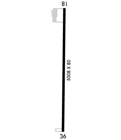
| Lat: N 3342.5 Long: W 08748.9 Elev: 357 Var: +03 Longest Runway: 5009 | ||
| CTAF: 122.8 | ||
| ||||||||||||||||||||||||||||||||||||||||||||
| ||||||||||||||||||||||||||||||||||||||||||||
| Rwy | Rwy | |||||||
| 5009x80 | 5009' | 5009x80 | 5009' | |||||
| Runway ID | Single Wheel | Double Wheel | Double Tandem Wheel | Dual Double Wheel |
| 01/19 | 15,000 | N/A | N/A | N/A |
| These numbers are Advisory and are not limits. The Airport Manager should have more accurate Weight Limits | ||||
 Airport Diagram might not be current. | |
| Facility Name: | RICHARD ARTHUR FLD |
| City Name: | FAYETTE |
| County: | FAYETTE |
| State abbrev: | AL |
| State Name: | ALABAMA |
| Ownership: | PUBLICLY OWNED |
| Use: | OPEN TO THE PUBLIC |
| Owner's Name: | CITY OF FAYETTE |
| Address: | 203 TEMPLE AVE NORTH |
| FAYETTE, AL 35555 | |
| Owner's Phone: | 205-932-5367 |
| Manager's Name: | KIP MADISON |
| Address: | 100 21ST STREET NORTH EAST |
| FAYETTE, AL 35555 | |
| Phone: | 205-932-3819 |
| FAA Region: | SOUTHERN |
| FAA Field Office: | JAN |
| Date | Sunrise | Sunset |
|---|---|---|
| 09/24/21 Friday | 6:41 | 18:46 |
| 09/25/21 Saturday | 6:41 | 18:44 |
| 09/26/21 Sunday | 6:42 | 18:43 |
| 09/27/21 Monday | 6:43 | 18:41 |
| 09/28/21 Tuesday | 6:43 | 18:40 |
| 09/29/21 Wednesday | 6:44 | 18:39 |
| 09/30/21 Thursday | 6:45 | 18:37 |
| 10/01/21 Friday | 6:45 | 18:36 |
| 10/02/21 Saturday | 6:46 | 18:35 |
| 10/03/21 Sunday | 6:47 | 18:33 |
| 10/04/21 Monday | 6:48 | 18:32 |
| 10/05/21 Tuesday | 6:48 | 18:31 |
| 10/06/21 Wednesday | 6:49 | 18:29 |
| 10/07/21 Thursday | 6:50 | 18:28 |
| Airport Attendance Schedule | MON-FRI 0900-1300 |
| Airport Status | OPERATIONAL (This Status can change at any time - please check NOTAMS) |
| Airport Lighting Schedule | ACTVT PAPI RWY 01 & 19; MIRL RWY 01/19 AND TWY LGTS - CTAF. |
| Airport Storage Available | Tie Downs |
| Extra Services Available | Flight Instruction |
| Wind Indicator | YES - (lighted) |
| Control Tower | NO |
| CTAF Frequency | 122.800 |
| Unicom Frequency | 122.800 |
| Rotating Beacon Color | CLEAR-GREEN (Light Land Airport) |
| Segmented Circle | YES |
| Landing Fee | NO |
| Airport Inspected | STATE - performed by STATE AERONAUTICAL PERSONNEL |
| Inspection Date | 09/04/2019 |
| Type of Fuel Available | Grade 100LL, JET A (freeze point -40C) |
| Airframe Repair Service | None |
| Power Plant Repair Service | None |
| Latitude | N3342.5 |
| Longitude | W08748.9 (ESTIMATED) |
| Arpt Elevation | 357ft (SURVEYED) |
| Magnetic Variation | 03W |
| 3 miles NE | of FAYETTE |
| Traffic Pattern Altitude | |
| Sectional Chart | ATLANTA |
| Operations (Reported) | Yearly | Avg. Daily |
|---|---|---|
| General Aviation Transient | 13000 | 36 |
| General Aviation Local | 2300 | 6 |
| Air Taxi | 0 | 0 |
| Commerical | 0 | 0 |
| Commuter | 0 | 0 |
| Military | 0 | 0 |
| Aircraft based on Field | |
|---|---|
| General Aviation Singles | 9 |
| General Aviation Multi | 0 |
| Jet Aircraft | 0 |
| General Aviation Helicopters | 1 |
| Military Aircraft | 0 |
| Gliders | 0 |
| Ultralights | 0 |
| FSS on field | NO |
| FSS tie-in | ANNISTON |
| FSS Phone | 1-800-WX-BRIEF |
| Who issues Notams | ANB |
| Notam D service at airport | YES |
| ARTCC Name | MEMPHIS |
| Airport Certification | |
| Aircraft Rescue & Firefighting Index | None |
| Airport of Entry | No |
| Custom Landing Rights | No |
| Joint Civil/Military | No |
| Military Landing rights | YES |
| NATIONAL PLAN OF INTEGRATED AIRPORT SYSTEMS (NPIAS) |
| GRANT AGREEMENT HAS EXPIRED; HOWEVER, AGREEMENT REMAINS IN EFFECT FOR THIS FACILITY AS LONG AS IT IS PUBLIC USE. |
| TWY LGTS FOR TWY TURNOFF ONLY. |
| DEER ON & INVOF ARPT. |
| FOR CD CTC COLUMBUS APCH AT 662-434-3044. |
Airport Communications & Frequencies:
| |||||||||||||||||
| Runway: 01 | Runway: 19 | ||
| Mag heading: | 6° | Mag heading: | 186° |
| Rwy Slope: | .53% Up | Rwy Slope: | -.53% Down |
| Approach: | Approach: | ||
| Pattern: | Left Traffic | Pattern: | Left Traffic |
| Markings: | NONPRECISION INSTRUMENT | Markings: | NONPRECISION INSTRUMENT |
| Marking Condition: | GOOD | Marking Condition: | GOOD |
| Arresting Dev: | Arresting Dev: | ||
| Lat & Long: | N3342.1 W08748.9 | Lat. & Long.: | N3343.0 W08748.9 |
| Elev: | 330.9 ft. MSL | Elev: | 357.4 ft. MSL |
| TCH: | 45 ft. AGL | TCH: | 45 ft. AGL |
| Visual Glide Path: | 3.00 degrees | Visual Glide Path: | 3.00 degrees |
| Displaced Threshold: | No | Displaced Threshold: | No |
| Touchdown Zone: | YES | Touchdown Zone: | YES |
| Touchdown Elev.: | 345.9 feet | Touchdown Elev.: | 357.4 feet |
| Visual Glide Slope: | 2-Light PAPI on LEFT side of Runway | Visual Glide Slope: | 2-Light PAPI on LEFT side of Runway |
| RVR Equipment: | RVR Equipment: | ||
| RVV Equipment: | NO | RVV Equipment: | NO |
| Approach Lights: | Approach Lights: | ||
| REIL: | NO | REIL: | NO |
| Centerline Lights: | NO | Centerline Lights: | NO |
| Touchdown lights: | NO | Touchdown lights: | NO |
| Runway Category: | Runway with a Visual Approach | Runway Category: | Runway with a Visual Approach |
| Declared Distances: | Declared Distances: | ||
| Obstructions: | TREES | Obstructions: | TREES |
| Marked: | NOT Marked/Lighted | Marked: | NOT Marked/Lighted |
| Clearance slope: | 34:1 | Clearance slope: | 13:1 |
| Obstruction height: | 29 feet AGL | Obstruction height: | 83 feet AGL |
| Dist. from runway: | 1210 feet | Dist. from runway: | 1299 feet |
| Centerline offset: | 184 right of centerline | Centerline offset: | 178 feet left of centerline |
| Comments: | Comments: |
Thanks for using FltPlan.com
all rights reserved © 1999-2021 by Flight Plan LLC
