
| GIDEON MEMORIAL GIDEON MO |
| |
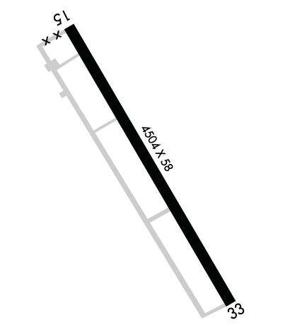
| Lat: N 3626.6 Long: W 08954.2 Elev: 269 Var: +02 Longest Runway: 4504 | ||
| CTAF: 122.9 | ||
| ||||||||||||||||||||||||||||||||
| ||||||||||||||||||||||||||||||||
| Rwy | Rwy | |||||||
| 4504x58 | 4504' | 4504x58 | 4504' | |||||
| Runway ID | Single Wheel | Double Wheel | Double Tandem Wheel | Dual Double Wheel |
| 15/33 | N/A | N/A | N/A | N/A |
| These numbers are Advisory and are not limits. The Airport Manager should have more accurate Weight Limits | ||||
 Airport Diagram might not be current. | |
| Facility Name: | GIDEON MEML |
| City Name: | GIDEON |
| County: | NEW MADRID |
| State abbrev: | MO |
| State Name: | MISSOURI |
| Ownership: | PUBLICLY OWNED |
| Use: | OPEN TO THE PUBLIC |
| Owner's Name: | CITY OF GIDEON |
| Address: | 109 MAIN ST, PO BOX 396 |
| GIDEON, MO 63848 | |
| Owner's Phone: | 573-448-3500 |
| Manager's Name: | JOSHUA ATCHLEY |
| Address: | 109 MAIN ST., PO BOX 396 |
| GIDEON, MO 63848 | |
| Phone: | 573-225-5225 |
| FAA Region: | CENTRAL |
| FAA Field Office: | NONE |
| Date | Sunrise | Sunset |
|---|---|---|
| 09/24/21 Friday | 6:49 | 18:54 |
| 09/25/21 Saturday | 6:50 | 18:52 |
| 09/26/21 Sunday | 6:50 | 18:51 |
| 09/27/21 Monday | 6:51 | 18:49 |
| 09/28/21 Tuesday | 6:52 | 18:48 |
| 09/29/21 Wednesday | 6:53 | 18:46 |
| 09/30/21 Thursday | 6:54 | 18:45 |
| 10/01/21 Friday | 6:55 | 18:43 |
| 10/02/21 Saturday | 6:55 | 18:42 |
| 10/03/21 Sunday | 6:56 | 18:41 |
| 10/04/21 Monday | 6:57 | 18:39 |
| 10/05/21 Tuesday | 6:58 | 18:38 |
| 10/06/21 Wednesday | 6:59 | 18:36 |
| 10/07/21 Thursday | 7:00 | 18:35 |
| Airport Attendance Schedule | IRREGULAR |
| Airport Status | OPERATIONAL (This Status can change at any time - please check NOTAMS) |
| Airport Lighting Schedule | |
| Airport Storage Available | Tie Downs |
| Extra Services Available | Crop Dusting |
| Wind Indicator | YES - (unlit) |
| Control Tower | NO |
| CTAF Frequency | 122.900 |
| Unicom Frequency | |
| Rotating Beacon Color | |
| Segmented Circle | YES |
| Landing Fee | NO |
| Airport Inspected | STATE - performed by STATE AERONAUTICAL PERSONNEL |
| Inspection Date | 08/01/2017 |
| Type of Fuel Available | None |
| Airframe Repair Service | None |
| Power Plant Repair Service | None |
| Latitude | N3626.6 |
| Longitude | W08954.2 (ESTIMATED) |
| Arpt Elevation | 269ft (ESTIMATED) |
| Magnetic Variation | 02W |
| 1 miles SE | of GIDEON |
| Traffic Pattern Altitude | |
| Sectional Chart | ST LOUIS |
| Operations (Reported) | Yearly | Avg. Daily |
|---|---|---|
| General Aviation Transient | 50 | 0 |
| General Aviation Local | 13000 | 36 |
| Air Taxi | 50 | 0 |
| Commerical | 0 | 0 |
| Commuter | 0 | 0 |
| Military | 50 | 0 |
| Aircraft based on Field | |
|---|---|
| General Aviation Singles | 4 |
| General Aviation Multi | 0 |
| Jet Aircraft | 0 |
| General Aviation Helicopters | 0 |
| Military Aircraft | 0 |
| Gliders | 0 |
| Ultralights | 0 |
| FSS on field | NO |
| FSS tie-in | SAINT LOUIS |
| FSS Phone | 1-800-WX-BRIEF |
| Who issues Notams | STL |
| Notam D service at airport | YES |
| ARTCC Name | MEMPHIS |
| Airport Certification | |
| Aircraft Rescue & Firefighting Index | None |
| Airport of Entry | No |
| Custom Landing Rights | No |
| Joint Civil/Military | No |
| Military Landing rights | No |
| SURPLUS PROPERTY AGREEMENT UNDER PUBLIC LAW 289 |
| GRANT AGREEMENT HAS EXPIRED; HOWEVER, AGREEMENT REMAINS IN EFFECT FOR THIS FACILITY AS LONG AS IT IS PUBLIC USE. |
| THIS AIRPORT HAS BEEN SURVEYED BY THE NATIONAL GEODETIC SURVEY. |
| N TWY TO RY 15 THLD CLSD; S TWY N OF RY 33 THLD CLSD. |
| CROP DUSTING & ULTRALIGHT ACFT ON & INVOF ARPT. |
| RY N/S CLSD; USED FOR FLYING OF MODEL PLANES. |
| ARPT CLSD DAILY SS-SR, EXCP HELICOPTER OPNS. |
| GRASS GROWING IN CRACKS ON PARL TWY. |
| FOR CD CTC MEMPHIS ARTCC AT 901-368-8453/8449. |
| RWY 15/3 3 WIDTH VARIES FM 58-60 FT. |
Airport Communications & Frequencies:
| |||||||
| Runway: 15 | Runway: 33 | ||
| Mag heading: | 152° | Mag heading: | 332° |
| Rwy Slope: | .04% Up | Rwy Slope: | -.04% Down |
| Approach: | Approach: | ||
| Pattern: | Left Traffic | Pattern: | Left Traffic |
| Markings: | NONPRECISION INSTRUMENT | Markings: | NONPRECISION INSTRUMENT |
| Marking Condition: | GOOD | Marking Condition: | GOOD |
| Arresting Dev: | Arresting Dev: | ||
| Lat & Long: | N3626.9 W08954.5 | Lat. & Long.: | N3626.3 W08954.0 |
| Elev: | 267.0 ft. MSL | Elev: | 269.0 ft. MSL |
| TCH: | TCH: | ||
| Visual Glide Path: | Visual Glide Path: | ||
| Displaced Threshold: | No | Displaced Threshold: | No |
| Touchdown Zone: | YES | Touchdown Zone: | YES |
| Touchdown Elev.: | 268.0 feet | Touchdown Elev.: | 269.0 feet |
| Visual Glide Slope: | Visual Glide Slope: | ||
| RVR Equipment: | RVR Equipment: | ||
| RVV Equipment: | NO | RVV Equipment: | NO |
| Approach Lights: | Approach Lights: | ||
| REIL: | NO | REIL: | NO |
| Centerline Lights: | NO | Centerline Lights: | NO |
| Touchdown lights: | NO | Touchdown lights: | NO |
| Runway Category: | Runway with a Non-precision Approach | Runway Category: | Runway with a Non-precision Approach |
| Declared Distances: | Declared Distances: | ||
| Obstructions: | TREES | Obstructions: | ROAD |
| Marked: | NOT Marked/Lighted | Marked: | NOT Marked/Lighted |
| Clearance slope: | 18:1 | Clearance slope: | 10:1 |
| Obstruction height: | 32 feet AGL | Obstruction height: | 13 feet AGL |
| Dist. from runway: | 780 feet | Dist. from runway: | 330 feet |
| Centerline offset: | 300 right of centerline | Centerline offset: | 250 feet right of centerline |
| Comments: | Comments: |
Thanks for using FltPlan.com
all rights reserved © 1999-2021 by Flight Plan LLC
