
| LAMAR COUNTY VERNON AL |
| |
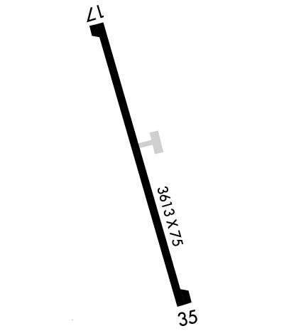
| Lat: N 3350.8 Long: W 08806.9 Elev: 463 Var: +02 Longest Runway: 3613 | ||
| CTAF: 122.9 | ||
| ||||||||||||||||||||||||||||||||
| ||||||||||||||||||||||||||||||||
| Rwy | Rwy | |||||||
| 3613x75 | 3613' | 3613x75 | 3613' | |||||
| Runway ID | Single Wheel | Double Wheel | Double Tandem Wheel | Dual Double Wheel |
| 17/35 | 16,000 | N/A | N/A | N/A |
| These numbers are Advisory and are not limits. The Airport Manager should have more accurate Weight Limits | ||||
 Airport Diagram might not be current. | |
| Facility Name: | LAMAR COUNTY |
| City Name: | VERNON |
| County: | LAMAR |
| State abbrev: | AL |
| State Name: | ALABAMA |
| Ownership: | PUBLICLY OWNED |
| Use: | OPEN TO THE PUBLIC |
| Owner's Name: | LAMAR COUNTY COMSN |
| Address: | PO BOX 338 |
| VERNON, AL 35592 | |
| Owner's Phone: | 205-695-9119 |
| Manager's Name: | CHRIS WILBANKS |
| Address: | PO BOX 338 |
| VERNON, AL 35592 | |
| Phone: | 205-695-7136 |
| FAA Region: | SOUTHERN |
| FAA Field Office: | JAN |
| Date | Sunrise | Sunset |
|---|---|---|
| 09/24/21 Friday | 6:42 | 18:47 |
| 09/25/21 Saturday | 6:42 | 18:45 |
| 09/26/21 Sunday | 6:43 | 18:44 |
| 09/27/21 Monday | 6:44 | 18:43 |
| 09/28/21 Tuesday | 6:45 | 18:41 |
| 09/29/21 Wednesday | 6:45 | 18:40 |
| 09/30/21 Thursday | 6:46 | 18:38 |
| 10/01/21 Friday | 6:47 | 18:37 |
| 10/02/21 Saturday | 6:47 | 18:36 |
| 10/03/21 Sunday | 6:48 | 18:34 |
| 10/04/21 Monday | 6:49 | 18:33 |
| 10/05/21 Tuesday | 6:50 | 18:32 |
| 10/06/21 Wednesday | 6:50 | 18:30 |
| 10/07/21 Thursday | 6:51 | 18:29 |
| Airport Attendance Schedule | UNATTENDED |
| Airport Status | OPERATIONAL (This Status can change at any time - please check NOTAMS) |
| Airport Lighting Schedule | ARPT LGTS INOP. |
| Airport Storage Available | NONE |
| Extra Services Available | NONE |
| Wind Indicator | YES - (unlit) |
| Control Tower | NO |
| CTAF Frequency | 122.900 |
| Unicom Frequency | |
| Rotating Beacon Color | |
| Segmented Circle | NO |
| Landing Fee | NO |
| Airport Inspected | STATE - performed by STATE AERONAUTICAL PERSONNEL |
| Inspection Date | 06/17/2021 |
| Type of Fuel Available | None |
| Airframe Repair Service | NONE |
| Power Plant Repair Service | NONE |
| Latitude | N3350.8 |
| Longitude | W08806.9 (ESTIMATED) |
| Arpt Elevation | 463ft (SURVEYED) |
| Magnetic Variation | 02W |
| 6 miles N | of VERNON |
| Traffic Pattern Altitude | |
| Sectional Chart | MEMPHIS |
| Operations (Reported) | Yearly | Avg. Daily |
|---|---|---|
| General Aviation Transient | 1460 | 4 |
| General Aviation Local | 144 | 0 |
| Air Taxi | 0 | 0 |
| Commerical | 0 | 0 |
| Commuter | 0 | 0 |
| Military | 0 | 0 |
| Aircraft based on Field | |
|---|---|
| General Aviation Singles | 0 |
| General Aviation Multi | 0 |
| Jet Aircraft | 0 |
| General Aviation Helicopters | 0 |
| Military Aircraft | 0 |
| Gliders | 0 |
| Ultralights | 0 |
| FSS on field | NO |
| FSS tie-in | ANNISTON |
| FSS Phone | 1-800-WX-BRIEF |
| Who issues Notams | ANB |
| Notam D service at airport | YES |
| ARTCC Name | MEMPHIS |
| Airport Certification | |
| Aircraft Rescue & Firefighting Index | None |
| Airport of Entry | No |
| Custom Landing Rights | No |
| Joint Civil/Military | No |
| Military Landing rights | No |
| THIS AIRPORT HAS BEEN SURVEYED BY THE NATIONAL GEODETIC SURVEY. |
| FOR CD CTC MEMPHIS ARTCC AT 901-368-8453/8449. |
| ALL ARPT LGT OTS. |
| RWY 17/3 5 WDSPRD JOINT CRACKING WITH VEGETATION. |
| RWY 17/3 5 ARPT LGTS INOP. |
Airport Communications & Frequencies:
| |||||||||||||||
| Runway: 17 | Runway: 35 | ||
| Mag heading: | 168° | Mag heading: | 348° |
| Rwy Slope: | -.17% Down | Rwy Slope: | .17% Up |
| Approach: | Approach: | ||
| Pattern: | Left Traffic | Pattern: | Left Traffic |
| Markings: | NONPRECISION INSTRUMENT | Markings: | NONPRECISION INSTRUMENT |
| Marking Condition: | POOR; RWY MARKINGS POOR DUE TO FADING | Marking Condition: | POOR; RWY MARKINGS POOR DUE TO FADING |
| Arresting Dev: | Arresting Dev: | ||
| Lat & Long: | N3351.1 W08807.0 | Lat. & Long.: | N3350.5 W08806.8 |
| Elev: | 463.0 ft. MSL | Elev: | 457.0 ft. MSL |
| TCH: | TCH: | ||
| Visual Glide Path: | Visual Glide Path: | ||
| Displaced Threshold: | No | Displaced Threshold: | No |
| Touchdown Zone: | YES | Touchdown Zone: | YES |
| Touchdown Elev.: | 463.0 feet | Touchdown Elev.: | 463.0 feet |
| Visual Glide Slope: | PULSATING/STEADY BURNING VASI ON LEFT SIDE OF RUNWAY | Visual Glide Slope: | PULSATING/STEADY BURNING VASI ON LEFT SIDE OF RUNWAY |
| RVR Equipment: | RVR Equipment: | ||
| RVV Equipment: | NO | RVV Equipment: | NO |
| Approach Lights: | Approach Lights: | ||
| REIL: | NO | REIL: | NO |
| Centerline Lights: | NO | Centerline Lights: | NO |
| Touchdown lights: | NO | Touchdown lights: | NO |
| Runway Category: | Runway with a Non-precision Approach | Runway Category: | Runway with a Non-precision Approach |
| Declared Distances: | Declared Distances: | ||
| Obstructions: | TREES | Obstructions: | TREES |
| Marked: | NOT Marked/Lighted | Marked: | NOT Marked/Lighted |
| Clearance slope: | 9:1 | Clearance slope: | |
| Obstruction height: | 14 feet AGL | Obstruction height: | 17 feet AGL |
| Dist. from runway: | 336 feet | Dist. from runway: | 202 feet |
| Centerline offset: | 137 left of centerline | Centerline offset: | 11 feet left of centerline |
| Comments: | 13 FT TREE 160 FT FM RWY END 111 FT RIGHT OF CNTRLN, 0:1 OBST CLNC; 18 FT TREE 149 FT FM RWY END 126 FT RIGHT OF CNTRLN; 11 FT TREE 163 FT FM RWY END 94 FT RIGHT OF CNTRLN; 6 FT TREE 197 FT FM RWY END 96 FT LEFT OF CNTRLN; 2 FT FENCE 196 FT FM RWY END 109 FT LEFT OF CNTRLN. | Comments: | 11 FT TREE 189 FT FM RWY END 71 FT RIGHT OF CNTRLN, 0:1 OBST CLNC; 22 FT TREE 198 FT FM RWY END 125 FT RIGHT OF CNTRLN; 16 FT TREE 191 FT FM RWY END 74 FT LEFT OF CNTRLN. |
Thanks for using FltPlan.com
all rights reserved © 1999-2021 by Flight Plan LLC
