
| OKTIBBEHA STARKVILLE MS |
| |
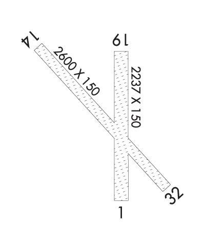
| Lat: N 3329.9 Long: W 08840.9 Elev: 250 Var: -02 Longest Runway: 2600 | ||
| CTAF: 122.8 | ||
| ||
| Rwy | Rwy | |||||||
| 2237x150 | 2237' | 2237x150 | 2237' | |||||
| 2600x150 | 2600' | 2600x150 | 2600' | |||||
| Runway ID | Single Wheel | Double Wheel | Double Tandem Wheel | Dual Double Wheel |
| 01/19 | N/A | N/A | N/A | N/A |
| 14/32 | N/A | N/A | N/A | N/A |
| These numbers are Advisory and are not limits. The Airport Manager should have more accurate Weight Limits | ||||
 Airport Diagram might not be current. | |
| Facility Name: | OKTIBBEHA |
| City Name: | STARKVILLE |
| County: | OKTIBBEHA |
| State abbrev: | MS |
| State Name: | MISSISSIPPI |
| Ownership: | PRIVATELY OWNED |
| Use: | OPEN TO THE PUBLIC |
| Owner's Name: | DOUG CAMP |
| Address: | 1606 CAMP AIRPORT RD |
| STARKVILLE, MS 39759 | |
| Owner's Phone: | 662-431-2345 |
| Manager's Name: | DOUG CAMP |
| Address: | 1606 CAMP AIRPORT RD |
| STARKVILLE, MS 39759 | |
| Phone: | 662-341-2345 |
| FAA Region: | SOUTHERN |
| FAA Field Office: | JAN |
| Date | Sunrise | Sunset |
|---|---|---|
| 09/24/21 Friday | 6:44 | 18:49 |
| 09/25/21 Saturday | 6:45 | 18:48 |
| 09/26/21 Sunday | 6:45 | 18:46 |
| 09/27/21 Monday | 6:46 | 18:45 |
| 09/28/21 Tuesday | 6:47 | 18:43 |
| 09/29/21 Wednesday | 6:47 | 18:42 |
| 09/30/21 Thursday | 6:48 | 18:41 |
| 10/01/21 Friday | 6:49 | 18:39 |
| 10/02/21 Saturday | 6:50 | 18:38 |
| 10/03/21 Sunday | 6:50 | 18:37 |
| 10/04/21 Monday | 6:51 | 18:35 |
| 10/05/21 Tuesday | 6:52 | 18:34 |
| 10/06/21 Wednesday | 6:52 | 18:33 |
| 10/07/21 Thursday | 6:53 | 18:31 |
| Airport Attendance Schedule | SAT-SUN ALL |
| Airport Status | OPERATIONAL (This Status can change at any time - please check NOTAMS) |
| Airport Lighting Schedule | |
| Airport Storage Available | Tie Downs, Hanger |
| Extra Services Available | NONE |
| Wind Indicator | YES - (unlit) |
| Control Tower | NO |
| CTAF Frequency | 122.800 |
| Unicom Frequency | 122.800; UNICOM OTS INDEFLY. |
| Rotating Beacon Color | |
| Segmented Circle | NO |
| Landing Fee | NO |
| Airport Inspected | STATE - performed by STATE AERONAUTICAL PERSONNEL |
| Inspection Date | 01/22/2021 |
| Type of Fuel Available | None |
| Airframe Repair Service | None |
| Power Plant Repair Service | None |
| Latitude | N3329.9 |
| Longitude | W08840.9 (ESTIMATED) |
| Arpt Elevation | 250ft (ESTIMATED) |
| Magnetic Variation | 02E |
| 7 miles NE | of STARKVILLE |
| Traffic Pattern Altitude | |
| Sectional Chart | MEMPHIS |
| Operations (Reported) | Yearly | Avg. Daily |
|---|---|---|
| General Aviation Transient | 500 | 1 |
| General Aviation Local | 2200 | 6 |
| Air Taxi | 0 | 0 |
| Commerical | 0 | 0 |
| Commuter | 0 | 0 |
| Military | 200 | 1 |
| Aircraft based on Field | |
|---|---|
| General Aviation Singles | 10 |
| General Aviation Multi | 0 |
| Jet Aircraft | 0 |
| General Aviation Helicopters | 0 |
| Military Aircraft | 0 |
| Gliders | 0 |
| Ultralights | 0 |
| FSS on field | NO |
| FSS tie-in | GREENWOOD |
| FSS Phone | 1-800-WX-BRIEF |
| Who issues Notams | GWO |
| Notam D service at airport | YES |
| ARTCC Name | MEMPHIS |
| Airport Certification | |
| Aircraft Rescue & Firefighting Index | None |
| Airport of Entry | No |
| Custom Landing Rights | No |
| Joint Civil/Military | No |
| Military Landing rights | YES |
| FOR CD CTC MEMPHIS ARTCC AT 901-368-8453/8449. |
| RWY 01/1 9 MKD BY MOWING & WHITE JUGS 75 FT APART. |
| RWY 14/3 2 MKD BY MOWING & WHITE JUGS 75 FT APART. |
Airport Communications & Frequencies:
| |||||||||||||||||
| Runway: 01 | Runway: 19 | ||
| Mag heading: | 6° | Mag heading: | 186° |
| Rwy Slope: | .07% Up | Rwy Slope: | -.07% Down |
| Approach: | Approach: | ||
| Pattern: | Left Traffic | Pattern: | Left Traffic |
| Markings: | NONSTANDARD | Markings: | NONSTANDARD |
| Marking Condition: | FAIR | Marking Condition: | FAIR |
| Arresting Dev: | Arresting Dev: | ||
| Lat & Long: | N3329.7 W08840.9 | Lat. & Long.: | N3330.0 W08840.8 |
| Elev: | 248.5 ft. MSL | Elev: | 250.0 ft. MSL |
| TCH: | TCH: | ||
| Visual Glide Path: | Visual Glide Path: | ||
| Displaced Threshold: | No | Displaced Threshold: | No |
| Touchdown Zone: | NO | Touchdown Zone: | NO |
| Touchdown Elev.: | Touchdown Elev.: | ||
| Visual Glide Slope: | Visual Glide Slope: | ||
| RVR Equipment: | RVR Equipment: | ||
| RVV Equipment: | NO | RVV Equipment: | NO |
| Approach Lights: | Approach Lights: | ||
| REIL: | NO | REIL: | NO |
| Centerline Lights: | NO | Centerline Lights: | NO |
| Touchdown lights: | NO | Touchdown lights: | NO |
| Runway Category: | Runway with a Visual Approach | Runway Category: | Runway with a Visual Approach |
| Declared Distances: | Declared Distances: | ||
| Obstructions: | TREES | Obstructions: | TREES |
| Marked: | NOT Marked/Lighted | Marked: | NOT Marked/Lighted |
| Clearance slope: | 23:1 | Clearance slope: | 22:1 |
| Obstruction height: | 17 feet AGL | Obstruction height: | 59 feet AGL |
| Dist. from runway: | 400 feet | Dist. from runway: | 1350 feet |
| Centerline offset: | 130 left of centerline | Centerline offset: | |
| Comments: | Comments: |
| Runway: 14 | Runway: 32 | ||
| Mag heading: | 140° | Mag heading: | 320° |
| Rwy Slope: | .05% Up | Rwy Slope: | -.05% Down |
| Approach: | Approach: | ||
| Pattern: | Left Traffic | Pattern: | Left Traffic |
| Markings: | NONSTANDARD | Markings: | NONSTANDARD |
| Marking Condition: | FAIR | Marking Condition: | FAIR |
| Arresting Dev: | Arresting Dev: | ||
| Lat & Long: | N3330.0 W08841.1 | Lat. & Long.: | N3329.7 W08840.7 |
| Elev: | 245.8 ft. MSL | Elev: | 247.0 ft. MSL |
| TCH: | TCH: | ||
| Visual Glide Path: | Visual Glide Path: | ||
| Displaced Threshold: | No | Displaced Threshold: | No |
| Touchdown Zone: | YES | Touchdown Zone: | YES |
| Touchdown Elev.: | 250.0 feet | Touchdown Elev.: | 250.0 feet |
| Visual Glide Slope: | Visual Glide Slope: | ||
| RVR Equipment: | RVR Equipment: | ||
| RVV Equipment: | NO | RVV Equipment: | NO |
| Approach Lights: | Approach Lights: | ||
| REIL: | NO | REIL: | NO |
| Centerline Lights: | NO | Centerline Lights: | NO |
| Touchdown lights: | NO | Touchdown lights: | NO |
| Runway Category: | Runway with a Visual Approach | Runway Category: | Runway with a Visual Approach |
| Declared Distances: | Declared Distances: | ||
| Obstructions: | TREES | Obstructions: | TREES |
| Marked: | NOT Marked/Lighted | Marked: | NOT Marked/Lighted |
| Clearance slope: | 23:1 | Clearance slope: | 30:1 |
| Obstruction height: | 77 feet AGL | Obstruction height: | 56 feet AGL |
| Dist. from runway: | 1800 feet | Dist. from runway: | 1700 feet |
| Centerline offset: | Centerline offset: | ||
| Comments: | Comments: |
Thanks for using FltPlan.com
all rights reserved © 1999-2021 by Flight Plan LLC
