
| ARNOLD FIELD (CLOSED) HALLS TN |
| |
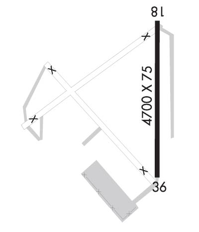
| Lat: N 3554.2 Long: W 08923.8 Elev: 292 Var: -02 Longest Runway: 4700 | ||
| CTAF: 122.9 | ||
| ||
| Rwy | Rwy | |||||||
| 4700x75 | 4700' | 4700x75 | 4700' | |||||
| Runway ID | Single Wheel | Double Wheel | Double Tandem Wheel | Dual Double Wheel |
| 18/36 | N/A | N/A | N/A | N/A |
| These numbers are Advisory and are not limits. The Airport Manager should have more accurate Weight Limits | ||||
| FltPlan does not have IFR approach charts available for KM31. |
 Airport Diagram might not be current. | |
| Facility Name: | ARNOLD FLD |
| City Name: | HALLS |
| County: | LAUDERDALE |
| State abbrev: | TN |
| State Name: | TENNESSEE |
| Ownership: | PUBLICLY OWNED |
| Use: | OPEN TO THE PUBLIC |
| Owner's Name: | TOWN OF HALLS |
| Address: | 208 NORTH CHURCH STREET |
| HALLS, TN 38040 | |
| Owner's Phone: | 731-836-9653 |
| Manager's Name: | FRED TAYLOR |
| Address: | 100 AIRPORT ROAD |
| HALLS, TN 38040 | |
| Phone: | 731-676-3690 |
| FAA Region: | SOUTHERN |
| FAA Field Office: | MEM |
| Date | Sunrise | Sunset |
|---|---|---|
| 06/19/25 Thursday | 5:41 | 20:17 |
| 06/20/25 Friday | 5:41 | 20:17 |
| 06/21/25 Saturday | 5:41 | 20:17 |
| 06/22/25 Sunday | 5:42 | 20:17 |
| 06/23/25 Monday | 5:42 | 20:18 |
| 06/24/25 Tuesday | 5:42 | 20:18 |
| 06/25/25 Wednesday | 5:42 | 20:18 |
| 06/26/25 Thursday | 5:43 | 20:18 |
| 06/27/25 Friday | 5:43 | 20:18 |
| 06/28/25 Saturday | 5:43 | 20:18 |
| 06/29/25 Sunday | 5:44 | 20:18 |
| 06/30/25 Monday | 5:44 | 20:18 |
| 07/01/25 Tuesday | 5:45 | 20:18 |
| 07/02/25 Wednesday | 5:45 | 20:18 |
| Airport Attendance Schedule | 7 Days A Week IREG |
| Airport Status | CLOSED INDEFINITELY (This Status can change at any time - please check NOTAMS) |
| Airport Lighting Schedule | |
| Airport Storage Available | Tie Downs |
| Extra Services Available | Crop Dusting |
| Wind Indicator | YES - (unlit) |
| Control Tower | NO |
| CTAF Frequency | 122.900 |
| Unicom Frequency | |
| Rotating Beacon Color | |
| Segmented Circle | NO |
| Landing Fee | NO |
| Airport Inspected | STATE - performed by STATE AERONAUTICAL PERSONNEL |
| Inspection Date | 07/19/2022 |
| Type of Fuel Available | Grade 100LL |
| Airframe Repair Service | NONE |
| Power Plant Repair Service | NONE |
| Latitude | N3554.2 |
| Longitude | W08923.8 (ESTIMATED) |
| Arpt Elevation | 292ft (ESTIMATED) |
| Magnetic Variation | 02E |
| 2 miles NW | of HALLS |
| Traffic Pattern Altitude | |
| Sectional Chart | MEMPHIS |
| Operations (Reported) | Yearly | Avg. Daily |
|---|---|---|
| General Aviation Transient | 0 | 0 |
| General Aviation Local | 0 | 0 |
| Air Taxi | 0 | 0 |
| Commerical | 0 | 0 |
| Commuter | 0 | 0 |
| Military | 0 | 0 |
| Aircraft based on Field | |
|---|---|
| General Aviation Singles | 0 |
| General Aviation Multi | 0 |
| Jet Aircraft | 0 |
| General Aviation Helicopters | 0 |
| Military Aircraft | 0 |
| Gliders | 0 |
| Ultralights | 0 |
| FSS on field | NO |
| FSS tie-in | JACKSON |
| FSS Phone | 1-800-WX-BRIEF |
| Who issues Notams | MKL |
| Notam D service at airport | YES |
| ARTCC Name | MEMPHIS |
| Airport Certification | |
| Aircraft Rescue & Firefighting Index | None |
| Airport of Entry | No |
| Custom Landing Rights | No |
| Joint Civil/Military | No |
| Military Landing rights | No |
| THERE MAY BE VEHICLE TFC ON ABND RWY SYS. |
| RY 18/36 HAS 500 FT STOPWAY ON N END. STOPWAY MARKINGS ARE FADED & A 6 FT FENCE CROSSES THE END OF THE STOPWAY. |
| WATERFOWL REFUGE 1/4 NM E OF ARPT. |
| FOR CD CTC MEMPHIS ARTCC AT 901-368-8453/8449. |
| AIRPORT IS CLOSED INDEFINITELY |
| (ARPT STATUS) ARPT CLSD INDEFLY. |
| Runway: 18 | Runway: 36 | ||
| Mag heading: | N/A | Mag heading: | N/A |
| Approach: | Approach: | ||
| Pattern: | Right Traffic | Pattern: | Left Traffic |
| Markings: | BASIC | Markings: | BASIC |
| Marking Condition: | FAIR | Marking Condition: | FAIR |
| Arresting Dev: | Arresting Dev: | ||
| Lat & Long: | Lat. & Long.: | ||
| Elev: | N/A | Elev: | N/A |
| TCH: | TCH: | ||
| Visual Glide Path: | Visual Glide Path: | ||
| Displaced Threshold: | No | Displaced Threshold: | No |
| Touchdown Zone: | NO | Touchdown Zone: | NO |
| Touchdown Elev.: | Touchdown Elev.: | ||
| Visual Glide Slope: | Visual Glide Slope: | ||
| RVR Equipment: | RVR Equipment: | ||
| RVV Equipment: | NO | RVV Equipment: | NO |
| Approach Lights: | Approach Lights: | ||
| REIL: | NO | REIL: | NO |
| Centerline Lights: | NO | Centerline Lights: | NO |
| Touchdown lights: | NO | Touchdown lights: | NO |
| Runway Category: | Runway with a Visual Approach | Runway Category: | Runway with a Visual Approach |
| Declared Distances: | Declared Distances: | ||
| Obstructions: | TREE | Obstructions: | |
| Marked: | NOT Marked/Lighted | Marked: | |
| Clearance slope: | 12:1 | Clearance slope: | 20:1 |
| Obstruction height: | 46 feet AGL | Obstruction height: | |
| Dist. from runway: | 736 feet | Dist. from runway: | |
| Centerline offset: | 171 right of centerline | Centerline offset: | |
| Comments: | Comments: |
Thanks for using FltPlan.com
all rights reserved © 1999-2025 by Flight Plan LLC
