
| LYNCHBURG RGNL- PRESTON GLENN LYNCHBURG VA |
| |
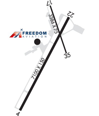
| Lat: N 3719.5 Long: W 07912.1 Elev: 938 Var: +08 Longest Runway: 7100 | ||
| Dept. ATIS: 119.8 Arr. ATIS: 119.8 AWOS: 119.8 Ground: 121.9 Tower: 127.65 | ||
| |||||||||||||||||||||||||||||||||||||||||||||||||||||||||||||||||||||
| |||||||||||||||||||||||||||||||||||||||||||||||||||||||||||||||||||||
| |||||||||||||||||||||||||||||||||||||||||||||||||||||||||||||||||||||
| Rwy | Rwy | |||||||
| 7100x150 | 7100' | 110.10 - 035° | 7100x150 | 7100' | ||||
| 3386x75 | 3386' | 3386x75 | 3386' | |||||
| Runway ID | Single Wheel | Double Wheel | Double Tandem Wheel | Dual Double Wheel |
| 04/22 | 90,000 | 108,000 | 170,000 | N/A |
| 17/35 | 25,000 | 35,000 | 55,000 | N/A |
| These numbers are Advisory and are not limits. The Airport Manager should have more accurate Weight Limits | ||||
 Airport Diagram might not be current. | |
| Facility Name: | LYNCHBURG RGNL/PRESTON GLENN FLD |
| City Name: | LYNCHBURG |
| County: | CAMPBELL |
| State abbrev: | VA |
| State Name: | VIRGINIA |
| Ownership: | PUBLICLY OWNED |
| Use: | OPEN TO THE PUBLIC |
| Owner's Name: | CITY OF LYNCHBURG |
| Address: | 350 TERMINAL DRIVE, SUITE 100 |
| LYNCHBURG, VA 24502 | |
| Owner's Phone: | 434-455-6090 |
| Manager's Name: | ANDREW LAGALA |
| Address: | 350 TERMINAL DRIVE, SUITE 100 |
| LYNCHBURG, VA 24502 | |
| Phone: | 434-455-6090 |
| FAA Region: | EASTERN |
| FAA Field Office: | DCA |

| Date | Sunrise | Sunset |
|---|---|---|
| 09/24/21 Friday | 7:06 | 19:11 |
| 09/25/21 Saturday | 7:07 | 19:10 |
| 09/26/21 Sunday | 7:08 | 19:08 |
| 09/27/21 Monday | 7:09 | 19:06 |
| 09/28/21 Tuesday | 7:09 | 19:05 |
| 09/29/21 Wednesday | 7:10 | 19:03 |
| 09/30/21 Thursday | 7:11 | 19:02 |
| 10/01/21 Friday | 7:12 | 19:00 |
| 10/02/21 Saturday | 7:13 | 18:59 |
| 10/03/21 Sunday | 7:14 | 18:57 |
| 10/04/21 Monday | 7:15 | 18:56 |
| 10/05/21 Tuesday | 7:15 | 18:54 |
| 10/06/21 Wednesday | 7:16 | 18:53 |
| 10/07/21 Thursday | 7:17 | 18:51 |
| Airport Attendance Schedule | 7 Days A Week 0500-2359 |
| Airport Status | OPERATIONAL (This Status can change at any time - please check NOTAMS) |
| Airport Lighting Schedule | WHEN ATCT CLSD ACTVT MALSR RWY 04; HIRL RWY 04/22; TWY LGTS - CTAF. REIL 17/35; PAPI RWY 17/35; MIRL RWY 17/35 UNAVBL WHEN ATCT CLSD. RWY 04/22 PAPI LGTD 24 HRS. |
| Airport Storage Available | Tie Downs, Hanger |
| Extra Services Available | Air Ambulance, Avionics, Cargo Handling, Charter, Flight Instruction, Aircraft Rental, Aircraft Sales |
| Wind Indicator | YES - (lighted) |
| Control Tower | YES |
| CTAF Frequency | 127.650 |
| Unicom Frequency | 122.950 |
| Rotating Beacon Color | CLEAR-GREEN (Light Land Airport) |
| Segmented Circle | NO |
| Landing Fee | NO |
| Airport Inspected | FEDERAL - performed by FAA AIRPORTS FIELD PERSONNEL |
| Inspection Date | 03/30/2021 |
| Type of Fuel Available | Grade 100LL, JET A (freeze point -40C) |
| Airframe Repair Service | MAJOR |
| Power Plant Repair Service | MAJOR |
| Latitude | N3719.5 |
| Longitude | W07912.1 (ESTIMATED) |
| Arpt Elevation | 938ft (SURVEYED) |
| Magnetic Variation | 08W |
| 5 miles SW | of LYNCHBURG |
| Traffic Pattern Altitude | |
| Sectional Chart | CINCINNATI |
| Operations (Reported) | Yearly | Avg. Daily |
|---|---|---|
| General Aviation Transient | 30619 | 84 |
| General Aviation Local | 49108 | 135 |
| Air Taxi | 3546 | 10 |
| Commerical | 1278 | 4 |
| Commuter | 0 | 0 |
| Military | 1179 | 3 |
| Aircraft based on Field | |
|---|---|
| General Aviation Singles | 73 |
| General Aviation Multi | 17 |
| Jet Aircraft | 9 |
| General Aviation Helicopters | 2 |
| Military Aircraft | 0 |
| Gliders | 0 |
| Ultralights | 0 |
| FSS on field | NO |
| FSS tie-in | LEESBURG |
| FSS Phone | 1-800-WX-BRIEF |
| Who issues Notams | LYH |
| Notam D service at airport | YES |
| ARTCC Name | WASHINGTON |
| Airport Certification | AIRPORT RECEIVING SCHEDULED AIR CARRIER SERVICE FROM CARRIERS CERTIFICATED BY THE CIVIL AERONAUTICS BOARD; PPR 12 HRS FOR UNSKED ACR OPNS WITH MORE THAN 30 PSGR SEATS. CALL ARFF 434-582-1157. INDEX "B" COVERAGE PRVDD. |
| Aircraft Rescue & Firefighting Index | AIRPORT HAS A CERTIFICATE UNDER CFR PART 139 |
| Airport of Entry | No |
| Custom Landing Rights | No |
| Joint Civil/Military | No |
| Military Landing rights | YES |
| NATIONAL PLAN OF INTEGRATED AIRPORT SYSTEMS (NPIAS) |
| GRANT AGREEMENTS UNDER FAAP/ADAP/AIP |
| COMPLIANCE WITH ACCESSIBILITY TO THE HANDICAPPED |
| ADVANCE PLANNING AGREEMENT UNDER FAAP |
| ASSURANCES PURSUANT TO TITLE VI, CIVIL RIGHTS ACT OF 1964 |
| AGREEMENT UNDER DLAND OR DCLA HAS EXPIRED. |
| THIS AIRPORT HAS BEEN SURVEYED BY THE NATIONAL GEODETIC SURVEY. |
| TWY G UNCONTROLLED-NOT VISIBLE FROM ATCT. |
| BIRDS AND OTHER WILDLIFE ON & INVOF ARPT. |
| RY 17/35 PPR FOR ACFT OVER 12500 LBS. |
| TWY G CLSD TO AIR CARRIER AND ACFT OVER 12500 LBS. |
| ALL SURFACES WORK IN PROGRESS MOWING/MAINTENANCE. |
| EXTSV FLT TRNG ON AND INVOF ARPT. |
| FOR CD WHEN ATCT CLSD CTC ROANOKE APCH AT 540-563-1307. |
| RWY 17/35 CLSD TO AIR CARRIER ACFT |
| RWY 17/3 5 RY 17/35 300 FT OVERRUN EACH END. |
Airport Communications & Frequencies:
| ||||||||||||||||||||||||||||||
| Runway: 04 | Runway: 22 | ||
| Mag heading: | 36° | Mag heading: | 216° |
| Rwy Slope: | .64% Up | Rwy Slope: | -.64% Down |
| Approach: | ILS | Approach: | |
| Pattern: | Left Traffic | Pattern: | Left Traffic |
| Markings: | PRECISION INSTRUMENT | Markings: | NONPRECISION INSTRUMENT |
| Marking Condition: | GOOD | Marking Condition: | GOOD |
| Arresting Dev: | Arresting Dev: | ||
| Lat & Long: | N3718.9 W07912.5 | Lat. & Long.: | N3719.9 W07911.8 |
| Elev: | 892.8 ft. MSL | Elev: | 938.0 ft. MSL |
| TCH: | 55 ft. AGL | TCH: | 45 ft. AGL |
| Visual Glide Path: | 3.00 degrees | Visual Glide Path: | 3.00 degrees |
| Displaced Threshold: | No | Displaced Threshold: | No |
| Touchdown Zone: | YES | Touchdown Zone: | YES |
| Touchdown Elev.: | 904.8 feet | Touchdown Elev.: | 938.1 feet |
| Visual Glide Slope: | 4-Light PAPI on LEFT side of Runway | Visual Glide Slope: | 4-Light PAPI on LEFT side of Runway |
| RVR Equipment: | TOUCHDOWN | RVR Equipment: | ROLLOUT |
| RVV Equipment: | YES | RVV Equipment: | NO |
| Approach Lights: | MALSR - 1,400 foot medium intensity approach lighting system with runway alignment indicator lights | Approach Lights: | |
| REIL: | NO | REIL: | YES |
| Centerline Lights: | NO | Centerline Lights: | NO |
| Touchdown lights: | NO | Touchdown lights: | NO |
| Runway Category: | Precision Instrument Runway | Runway Category: | Runway with a Non-precision Approach having visibility minimums greater than 3/4 mile |
| Declared Distances: | TORA:7100' TODA:7100' ASDA:6800' LDA:6800' | Declared Distances: | TORA:7100' TODA:7100' ASDA:7100' LDA:7100' |
| Runway: 17 | Runway: 35 | ||
| Mag heading: | 169° | Mag heading: | 349° |
| Rwy Slope: | -.01% Down | Rwy Slope: | .01% Up |
| Approach: | Approach: | ||
| Pattern: | Left Traffic | Pattern: | Left Traffic |
| Markings: | NONPRECISION INSTRUMENT | Markings: | NONPRECISION INSTRUMENT |
| Marking Condition: | GOOD | Marking Condition: | GOOD |
| Arresting Dev: | Arresting Dev: | ||
| Lat & Long: | N3720.0 W07912.1 | Lat. & Long.: | N3719.5 W07911.8 |
| Elev: | 921.5 ft. MSL | Elev: | 921.2 ft. MSL |
| TCH: | 16 ft. AGL | TCH: | 17 ft. AGL |
| Visual Glide Path: | 4.00 degrees | Visual Glide Path: | 4.00 degrees |
| Displaced Threshold: | No | Displaced Threshold: | No |
| Touchdown Zone: | YES | Touchdown Zone: | YES |
| Touchdown Elev.: | 932.7 feet | Touchdown Elev.: | 932.7 feet |
| Visual Glide Slope: | 2-Light PAPI on LEFT side of Runway | Visual Glide Slope: | 2-Light PAPI on LEFT side of Runway |
| RVR Equipment: | RVR Equipment: | ||
| RVV Equipment: | NO | RVV Equipment: | NO |
| Approach Lights: | Approach Lights: | ||
| REIL: | YES | REIL: | YES |
| Centerline Lights: | NO | Centerline Lights: | NO |
| Touchdown lights: | NO | Touchdown lights: | NO |
| Runway Category: | Runway with a Non-precision Approach | Runway Category: | Runway with a Non-precision Approach |
| Declared Distances: | TORA:3386' TODA:3386' ASDA:3386' LDA:3386' | Declared Distances: | TORA:3386' TODA:3386' ASDA:3386' LDA:3386' |
Thanks for using FltPlan.com
all rights reserved © 1999-2021 by Flight Plan LLC