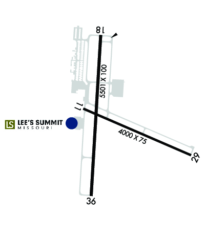
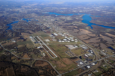
| LEE'S SUMMIT MUNI LEE'S SUMMIT MO |
| |
| Lat: N 3857.5 Long: W 09422.3 Elev: 1004 Var: -02 Longest Runway: 5501 | ||
| Clr Del: 118.45 AWOS: 124.17 CTAF: 122.8 | ||
| |||||||||||||||||||||||||||||||||||||||||||||||||||||||||||||||||||||
| |||||||||||||||||||||||||||||||||||||||||||||||||||||||||||||||||||||
| |||||||||||||||||||||||||||||||||||||||||||||||||||||||||||||||||||||
| Rwy | Rwy | |||||||
| 4000x75 | 4000' | 4000x75 | 4000' | |||||
| 5501x100 | 5501' | 5501x100 | 5501' | |||||
| Runway ID | Single Wheel | Double Wheel | Double Tandem Wheel | Dual Double Wheel |
| 11/29 | 30,000 | 30,000 | N/A | N/A |
| 18/36 | 40,000 | 60,000 | N/A | N/A |
| These numbers are Advisory and are not limits. The Airport Manager should have more accurate Weight Limits | ||||
 Airport Diagram might not be current. | |
| Facility Name: | LEE'S SUMMIT MUNI |
| City Name: | LEE'S SUMMIT |
| County: | JACKSON |
| State abbrev: | MO |
| State Name: | MISSOURI |
| Ownership: | PUBLICLY OWNED |
| Use: | OPEN TO THE PUBLIC |
| Owner's Name: | CITY OF LEE'S SUMMIT |
| Address: | 220 SE GREEN, P.O. BOX 1600 |
| LEES SUMMIT, MO 64063 | |
| Owner's Phone: | 816-969-1000 |
| Manager's Name: | JOHN OHRAZDA |
| Address: | 2751 NE DOUGLAS RD |
| LEES SUMMIT, MO 64064 | |
| Phone: | (816) 969-1800 |
| FAA Region: | CENTRAL |
| FAA Field Office: | NONE |
| Date | Sunrise | Sunset |
|---|---|---|
| 09/24/21 Friday | 7:07 | 19:12 |
| 09/25/21 Saturday | 7:08 | 19:10 |
| 09/26/21 Sunday | 7:09 | 19:08 |
| 09/27/21 Monday | 7:10 | 19:07 |
| 09/28/21 Tuesday | 7:10 | 19:05 |
| 09/29/21 Wednesday | 7:11 | 19:04 |
| 09/30/21 Thursday | 7:12 | 19:02 |
| 10/01/21 Friday | 7:13 | 19:00 |
| 10/02/21 Saturday | 7:14 | 18:59 |
| 10/03/21 Sunday | 7:15 | 18:57 |
| 10/04/21 Monday | 7:16 | 18:56 |
| 10/05/21 Tuesday | 7:17 | 18:54 |
| 10/06/21 Wednesday | 7:18 | 18:53 |
| 10/07/21 Thursday | 7:19 | 18:51 |
| Airport Attendance Schedule | 7 Days A Week 0600-1900 |
| Airport Status | OPERATIONAL (This Status can change at any time - please check NOTAMS) |
| Airport Lighting Schedule | SS-SR; ACTVT REIL RWYS 18 & 36; 11 & 29, MIRL RWYS 11/29 AND 18/36 - CTAF. PAPI RWYS 11 & 29,18 & 36 ON CONTINUOUSLY. |
| Airport Storage Available | Tie Downs, Hanger |
| Extra Services Available | Flight Instruction, Aircraft Rental, Annual Surveying |
| Wind Indicator | YES - (lighted) |
| Control Tower | NO |
| CTAF Frequency | 122.800 |
| Unicom Frequency | 122.800 |
| Rotating Beacon Color | CLEAR-GREEN (Light Land Airport) |
| Segmented Circle | YES |
| Landing Fee | NO |
| Airport Inspected | STATE - performed by STATE AERONAUTICAL PERSONNEL |
| Inspection Date | 08/02/2018 |
| Type of Fuel Available | Grade 100LL, JET A (freeze point -40C)MOGAS; -1024 HR CREDIT CARD SELF SERVICE FUELING SYSTEM AVBL FOR 100LL & MOGAS. MOBILE FUEL SERVICE JET A AND 100LL. FOR AFTER HRS FULL SVC FUELING CALL 816-969-1186. |
| Airframe Repair Service | MAJOR |
| Power Plant Repair Service | MAJOR |
| Latitude | N3857.5 |
| Longitude | W09422.3 (ESTIMATED) |
| Arpt Elevation | 1004ft (SURVEYED) |
| Magnetic Variation | 02E |
| 3 miles N | of LEE'S SUMMIT |
| Traffic Pattern Altitude | 800; TPA ACFT UNDER 6,000 LBS 800 FT AGL, ACFT OVER 6,000 LBS 1,500 FT AGL. |
| Sectional Chart | KANSAS CITY |
| Operations (Reported) | Yearly | Avg. Daily |
|---|---|---|
| General Aviation Transient | 15150 | 42 |
| General Aviation Local | 34850 | 95 |
| Air Taxi | 1750 | 5 |
| Commerical | 0 | 0 |
| Commuter | 0 | 0 |
| Military | 750 | 2 |
| Aircraft based on Field | |
|---|---|
| General Aviation Singles | 111 |
| General Aviation Multi | 8 |
| Jet Aircraft | 7 |
| General Aviation Helicopters | 3 |
| Military Aircraft | 0 |
| Gliders | 0 |
| Ultralights | 0 |
| FSS on field | NO |
| FSS tie-in | COLUMBIA |
| FSS Phone | 1-800-WX-BRIEF |
| Who issues Notams | LXT |
| Notam D service at airport | YES |
| ARTCC Name | KANSAS CITY |
| Airport Certification | |
| Aircraft Rescue & Firefighting Index | None |
| Airport of Entry | No |
| Custom Landing Rights | No |
| Joint Civil/Military | No |
| Military Landing rights | YES |
| NATIONAL PLAN OF INTEGRATED AIRPORT SYSTEMS (NPIAS) |
| GRANT AGREEMENTS UNDER FAAP/ADAP/AIP |
| ASSURANCES PURSUANT TO TITLE VI, CIVIL RIGHTS ACT OF 1964 |
| NO RIGHT TURNS UNDER 2500 FT MSL OR WITHIN 3 MI OF THE ARPT WHEN DEPARTING ON RY 29. |
| FOR CD CTC KANSAS CITY APCH AT 816-329-2710. |
| NO LEFT TURNS UNDER 1500 FT MSL OR WITHIN 1/2 MI OF THE END OF THE RY WHEN DEPARTING ON RY 18. |
| NO LEFT TURNS UNDER 2500 FT MSL OR WITHIN 3 MI OF THE ARPT DEPARTING ON RY 36. |
| WILDLIFE ON & INVOF ARPT. |
| WHEN WINDS ARE LESS THAN 5 KNOTS USE RY 18. |
| AER 18,36 & 29 ARE NOT MUTUALLY VSB DUE TO TRRN. |
| ARPT TRML BLDG OPEN 24 HRS. |
| RWY 18/36 GRAD 0.16%, RWY 11/29 GRAD 0.24% |
Airport Communications & Frequencies:
| ||||||||||||||||
| Runway: 11 | Runway: 29 | ||
| Mag heading: | 111° | Mag heading: | 291° |
| Rwy Slope: | .24% Up | Rwy Slope: | -.24% Down |
| Approach: | Approach: | ||
| Pattern: | Right Traffic | Pattern: | Left Traffic |
| Markings: | NONPRECISION INSTRUMENT | Markings: | NONPRECISION INSTRUMENT |
| Marking Condition: | GOOD | Marking Condition: | GOOD |
| Arresting Dev: | Arresting Dev: | ||
| Lat & Long: | N3857.6 W09422.5 | Lat. & Long.: | N3857.4 W09421.8 |
| Elev: | 991.8 ft. MSL | Elev: | 1001.4 ft. MSL |
| TCH: | 45 ft. AGL | TCH: | 40 ft. AGL |
| Visual Glide Path: | 3.00 degrees | Visual Glide Path: | 3.00 degrees |
| Displaced Threshold: | No | Displaced Threshold: | No |
| Touchdown Zone: | YES | Touchdown Zone: | YES |
| Touchdown Elev.: | 1004.1 feet | Touchdown Elev.: | 1004.1 feet |
| Visual Glide Slope: | 4-Light PAPI on LEFT side of Runway | Visual Glide Slope: | 4-Light PAPI on RIGHT side of Runway |
| RVR Equipment: | RVR Equipment: | ||
| RVV Equipment: | NO | RVV Equipment: | NO |
| Approach Lights: | Approach Lights: | ||
| REIL: | YES | REIL: | YES |
| Centerline Lights: | NO | Centerline Lights: | NO |
| Touchdown lights: | NO | Touchdown lights: | NO |
| Runway Category: | Runway with a Non-precision Approach having visibility minimums greater than 3/4 mile | Runway Category: | Runway with a Non-precision Approach having visibility minimums greater than 3/4 mile |
| Declared Distances: | Declared Distances: |
| Runway: 18 | Runway: 36 | ||
| Mag heading: | 181° | Mag heading: | 1° |
| Rwy Slope: | -.16% Down | Rwy Slope: | .16% Up |
| Approach: | Approach: | ||
| Pattern: | Left Traffic | Pattern: | Right Traffic |
| Markings: | NONPRECISION INSTRUMENT | Markings: | NONPRECISION INSTRUMENT |
| Marking Condition: | GOOD | Marking Condition: | GOOD |
| Arresting Dev: | Arresting Dev: | ||
| Lat & Long: | N3858.0 W09422.4 | Lat. & Long.: | N3857.1 W09422.5 |
| Elev: | 995.0 ft. MSL | Elev: | 986.0 ft. MSL |
| TCH: | 44 ft. AGL | TCH: | 45 ft. AGL |
| Visual Glide Path: | 3.00 degrees | Visual Glide Path: | 3.00 degrees |
| Displaced Threshold: | No | Displaced Threshold: | No |
| Touchdown Zone: | YES | Touchdown Zone: | YES |
| Touchdown Elev.: | 998.6 feet | Touchdown Elev.: | 997.1 feet |
| Visual Glide Slope: | 4-Light PAPI on LEFT side of Runway | Visual Glide Slope: | 4-Light PAPI on LEFT side of Runway |
| RVR Equipment: | RVR Equipment: | ||
| RVV Equipment: | NO | RVV Equipment: | NO |
| Approach Lights: | Approach Lights: | ||
| REIL: | YES | REIL: | YES |
| Centerline Lights: | NO | Centerline Lights: | NO |
| Touchdown lights: | NO | Touchdown lights: | NO |
| Runway Category: | Runway with a Non-precision Approach having visibility minimums greater than 3/4 mile | Runway Category: | Runway with a Non-precision Approach having visibility minimums greater than 3/4 mile |
| Declared Distances: | Declared Distances: |
Thanks for using FltPlan.com
all rights reserved © 1999-2021 by Flight Plan LLC