
| LEWISTOWN MUNI LEWISTOWN MT |
| |
| Lat: N 4703.0 Long: W 10928.0 Elev: 4170 Var: -11 Longest Runway: 6100 | ||
| AWOS: 135.07 CTAF: 123.0 | ||
| ||||||||||||||||||||||||||||||||||||||||||||
| ||||||||||||||||||||||||||||||||||||||||||||
| ||||||||||||||||||||||||||||||||||||||||||||
| ||||||||||||||||||||||||||||||||||||||||||||
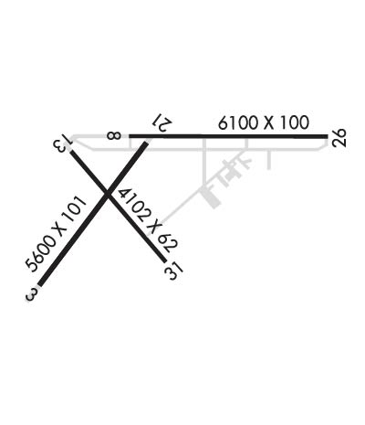
| Rwy | Rwy | |||||||
| 5600x101 | 5600' | 5600x101 | 5600' | |||||
| 6100x100 | 6100' | 6100x100 | 6100' | |||||
| 4102x62 | 4102' | 4102x62 | 4102' | |||||
| Runway ID | Single Wheel | Double Wheel | Double Tandem Wheel | Dual Double Wheel |
| 03/21 | 12,500 | 80,000 | 120,000 | N/A |
| 08/26 | 40,000 | 55,000 | 95,000 | N/A |
| 13/31 | 12,500 | N/A | N/A | N/A |
| These numbers are Advisory and are not limits. The Airport Manager should have more accurate Weight Limits | ||||
 Airport Diagram might not be current. | |
| Facility Name: | LEWISTOWN MUNI |
| City Name: | LEWISTOWN |
| County: | FERGUS |
| State abbrev: | MT |
| State Name: | MONTANA |
| Ownership: | PUBLICLY OWNED |
| Use: | OPEN TO THE PUBLIC |
| Owner's Name: | LEWISTOWN & FERGUS COUNTY |
| Address: | BOX 343 |
| LEWISTOWN, MT 59457 | |
| Owner's Phone: | 406-535-5119 |
| Manager's Name: | BRYON ARMOUR |
| Address: | P.O. BOX 343, 190 TERMINAL DRIVE |
| LEWISTOWN, MT 59457 | |
| Phone: | (406) 535-3264; OR CALL 406-350-3264. |
| FAA Region: | NORTHWEST MOUNTAIN |
| FAA Field Office: | HLN |

| Date | Sunrise | Sunset |
|---|---|---|
| 06/08/26 Monday | 5:23 | 21:11 |
| 06/09/26 Tuesday | 5:23 | 21:12 |
| 06/10/26 Wednesday | 5:23 | 21:12 |
| 06/11/26 Thursday | 5:22 | 21:13 |
| 06/12/26 Friday | 5:22 | 21:13 |
| 06/13/26 Saturday | 5:22 | 21:14 |
| 06/14/26 Sunday | 5:22 | 21:14 |
| 06/15/26 Monday | 5:22 | 21:15 |
| 06/16/26 Tuesday | 5:22 | 21:15 |
| 06/17/26 Wednesday | 5:22 | 21:16 |
| 06/18/26 Thursday | 5:22 | 21:16 |
| 06/19/26 Friday | 5:22 | 21:16 |
| 06/20/26 Saturday | 5:22 | 21:17 |
| 06/21/26 Sunday | 5:22 | 21:17 |
| Airport Attendance Schedule | MON-FRI 0800-1700 |
| Airport Status | OPERATIONAL (This Status can change at any time - please check NOTAMS) |
| Airport Lighting Schedule | ACTVT REIL RWYS 08 & 26; PAPI RWY 08; VASI RWY 26; MIRL RWYS 08/26 & 13/31; - CTAF. |
| Airport Storage Available | Tie Downs, Hanger |
| Extra Services Available | Crop Dusting, Avionics, Charter, Flight Instruction, Aircraft Rental, Aircraft Sales |
| Wind Indicator | YES - (lighted) |
| Control Tower | NO |
| CTAF Frequency | 123.000 |
| Unicom Frequency | 123.000 |
| Rotating Beacon Color | WG |
| Segmented Circle | YES |
| Landing Fee | NO |
| Airport Inspected | STATE - performed by STATE AERONAUTICAL PERSONNEL |
| Inspection Date | 09/25/2025 |
| Type of Fuel Available | Grade 100, Grade 100LL, JET A (freeze point -40C) |
| Airframe Repair Service | MAJOR |
| Power Plant Repair Service | MAJOR |
| Latitude | N4703.0 |
| Longitude | W10928.0 (ESTIMATED) |
| Arpt Elevation | 4170ft (SURVEYED) |
| Magnetic Variation | 11E |
| 2 miles SW | of LEWISTOWN |
| Traffic Pattern Altitude | |
| Sectional Chart | GREAT FALLS |
| Operations (Reported) | Yearly | Avg. Daily |
|---|---|---|
| General Aviation Transient | 0 | 0 |
| General Aviation Local | 0 | 0 |
| Air Taxi | 0 | 0 |
| Commerical | 0 | 0 |
| Commuter | 0 | 0 |
| Military | 0 | 0 |
| Aircraft based on Field | |
|---|---|
| General Aviation Singles | 0 |
| General Aviation Multi | 0 |
| Jet Aircraft | 0 |
| General Aviation Helicopters | 0 |
| Military Aircraft | 0 |
| Gliders | 0 |
| Ultralights | 0 |
| FSS on field | NO |
| FSS tie-in | GREAT FALLS |
| FSS Phone | 1-800-WX-BRIEF |
| Who issues Notams | LWT |
| Notam D service at airport | YES |
| ARTCC Name | SALT LAKE CITY |
| Airport Certification | |
| Aircraft Rescue & Firefighting Index | None |
| Airport of Entry | No |
| Custom Landing Rights | No |
| Joint Civil/Military | No |
| Military Landing rights | YES |
| NATIONAL PLAN OF INTEGRATED AIRPORT SYSTEMS (NPIAS) |
| GRANT AGREEMENTS UNDER FAAP/ADAP/AIP |
| SURPLUS PROPERTY AGREEMENT UNDER PUBLIC LAW 289 |
| ASSURANCES PURSUANT TO TITLE VI, CIVIL RIGHTS ACT OF 1964 |
| AGREEMENT UNDER DLAND OR DCLA HAS EXPIRED. |
| THIS AIRPORT HAS BEEN SURVEYED BY THE NATIONAL GEODETIC SURVEY. |
| ALL TWYS HAVE REFLECTORS EXCEPT TWY C, E, AND HALF OF A, WHICH ARE LGTD. |
| RY 03/21 DAY USE ONLY. |
| RWY 03/21 NOT MNTND IN WINTER; RWY 13/31 PLOWED AS NEEDED. |
| ARPT SFC CONDS NOT MNTD 1700-0500. |
| BIRDS ON AND INVOF AIRPORT. |
| FOR CD IF UNA TO CTC ON FSS FREQ, CTC SALT LAKE ARTCC AT 801-320-2568. |
| RWY 03/2 1 RWY 03/21 ASPH SPALLING. |
| RWY 03/2 1 1LOOSE GRAVEL SFC. |
Airport Communications & Frequencies:
| |||||||||
| Runway: 03 | Runway: 21 | ||
| Mag heading: | 27° | Mag heading: | 207° |
| Rwy Slope: | -.71% Down | Rwy Slope: | .71% Up |
| Approach: | Approach: | ||
| Pattern: | Left Traffic | Pattern: | Left Traffic |
| Markings: | BASIC | Markings: | BASIC |
| Marking Condition: | POOR; RWY 03/21 MRKGS FADED. | Marking Condition: | POOR |
| Arresting Dev: | Arresting Dev: | ||
| Lat & Long: | N4702.4 W10928.9 | Lat. & Long.: | N4703.1 W10928.0 |
| Elev: | 4170.4 ft. MSL | Elev: | 4130.5 ft. MSL |
| TCH: | TCH: | ||
| Visual Glide Path: | Visual Glide Path: | ||
| Displaced Threshold: | No | Displaced Threshold: | No |
| Touchdown Zone: | YES | Touchdown Zone: | YES |
| Touchdown Elev.: | 4170.4 feet | Touchdown Elev.: | 4151.9 feet |
| Visual Glide Slope: | Visual Glide Slope: | ||
| RVR Equipment: | RVR Equipment: | ||
| RVV Equipment: | NO | RVV Equipment: | NO |
| Approach Lights: | Approach Lights: | ||
| REIL: | NO | REIL: | NO |
| Centerline Lights: | NO | Centerline Lights: | NO |
| Touchdown lights: | NO | Touchdown lights: | NO |
| Runway Category: | Runway with a Visual Approach | Runway Category: | Runway with a Visual Approach |
| Declared Distances: | TORA:5600' TODA:5600' ASDA:5600' LDA:5600' | Declared Distances: | TORA:5600' TODA:5600' ASDA:5600' LDA:5600' |
| Runway: 08 | Runway: 26 | ||
| Mag heading: | 79° | Mag heading: | 259° |
| Rwy Slope: | -.26% Down | Rwy Slope: | .26% Up |
| Approach: | Approach: | ||
| Pattern: | Left Traffic | Pattern: | Left Traffic |
| Markings: | PRECISION INSTRUMENT | Markings: | PRECISION INSTRUMENT |
| Marking Condition: | GOOD | Marking Condition: | GOOD |
| Arresting Dev: | Arresting Dev: | ||
| Lat & Long: | N4703.2 W10928.2 | Lat. & Long.: | N4703.2 W10926.7 |
| Elev: | 4127.7 ft. MSL | Elev: | 4111.8 ft. MSL |
| TCH: | 51 ft. AGL | TCH: | 50 ft. AGL |
| Visual Glide Path: | 3.00 degrees | Visual Glide Path: | 3.00 degrees |
| Displaced Threshold: | No | Displaced Threshold: | No |
| Touchdown Zone: | YES | Touchdown Zone: | YES |
| Touchdown Elev.: | 4128.9 feet | Touchdown Elev.: | 4124.3 feet |
| Visual Glide Slope: | 2-Light PAPI on LEFT side of Runway | Visual Glide Slope: | 4-BOX VASI ON LEFT SIDE OF RUNWAY |
| RVR Equipment: | RVR Equipment: | ||
| RVV Equipment: | NO | RVV Equipment: | NO |
| Approach Lights: | Approach Lights: | ||
| REIL: | YES | REIL: | YES |
| Centerline Lights: | NO | Centerline Lights: | NO |
| Touchdown lights: | NO | Touchdown lights: | NO |
| Runway Category: | Runway with a Non-precision Approach having visibility minimums greater than 3/4 mile | Runway Category: | Runway with a Non-precision Approach having visibility minimums greater than 3/4 mile |
| Declared Distances: | TORA:6100' TODA:6100' ASDA:6100' LDA:6100' | Declared Distances: | TORA:6100' TODA:6100' ASDA:6100' LDA:6100' |
| Runway: 13 | Runway: 31 | ||
| Mag heading: | 129° | Mag heading: | 309° |
| Rwy Slope: | .75% Up | Rwy Slope: | -.75% Down |
| Approach: | Approach: | ||
| Pattern: | Left Traffic | Pattern: | Left Traffic |
| Markings: | BASIC | Markings: | BASIC |
| Marking Condition: | GOOD | Marking Condition: | GOOD |
| Arresting Dev: | Arresting Dev: | ||
| Lat & Long: | N4703.1 W10928.6 | Lat. & Long.: | N4702.6 W10927.9 |
| Elev: | 4131.7 ft. MSL | Elev: | 4162.6 ft. MSL |
| TCH: | TCH: | ||
| Visual Glide Path: | Visual Glide Path: | ||
| Displaced Threshold: | No | Displaced Threshold: | No |
| Touchdown Zone: | YES | Touchdown Zone: | YES |
| Touchdown Elev.: | 4154.3 feet | Touchdown Elev.: | 4162.6 feet |
| Visual Glide Slope: | Visual Glide Slope: | ||
| RVR Equipment: | RVR Equipment: | ||
| RVV Equipment: | NO | RVV Equipment: | NO |
| Approach Lights: | Approach Lights: | ||
| REIL: | NO | REIL: | NO |
| Centerline Lights: | NO | Centerline Lights: | NO |
| Touchdown lights: | NO | Touchdown lights: | NO |
| Runway Category: | Runway with a Visual Approach | Runway Category: | Runway with a Visual Approach |
| Declared Distances: | Declared Distances: |
Thanks for using FltPlan.com
all rights reserved © 1999-2026 by Flight Plan LLC