
| LIVERMORE MUNI LIVERMORE CA |
| |
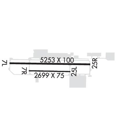
| Lat: N 3741.6 Long: W 12149.2 Elev: 400 Var: -16 Longest Runway: 5253 | ||
| Dept. ATIS: 119.65 Arr. ATIS: 119.65 Ground: 121.6 Tower: 118.1 | ||
| ||||||||||||||||||||||||||||||||||||||||||||
| ||||||||||||||||||||||||||||||||||||||||||||
| ||||||||||||||||||||||||||||||||||||||||||||
| ||||||||||||||||||||||||||||||||||||||||||||
| Rwy | Rwy | |||||||
| 5253x100 | 5253' | 5253x100 | 5253' | 110.50 - 254° | ||||
| 2699x75 | 2699' | 2699x75 | 2699' | |||||
| Runway ID | Single Wheel | Double Wheel | Double Tandem Wheel | Dual Double Wheel |
| 07L/25R | 45,000 | 90,000 | N/A | N/A |
| 07R/25L | 12,500 | N/A | N/A | N/A |
| H1 | N/A | N/A | N/A | N/A |
| These numbers are Advisory and are not limits. The Airport Manager should have more accurate Weight Limits | ||||
 Airport Diagram might not be current. | |
| Facility Name: | LIVERMORE MUNI |
| City Name: | LIVERMORE |
| County: | ALAMEDA |
| State abbrev: | CA |
| State Name: | CALIFORNIA |
| Ownership: | PUBLICLY OWNED |
| Use: | OPEN TO THE PUBLIC |
| Owner's Name: | CITY OF LIVERMORE |
| Address: | 1052 SOUTH LIVERMORE AVE |
| LIVERMORE, CA 94550 | |
| Owner's Phone: | 925-960-4200 |
| Manager's Name: | BENEDICT STUTH |
| Address: | 680 TERMINAL CIRCLE |
| LIVERMORE, CA 94551 | |
| Phone: | 925-960-8230 |
| FAA Region: | WESTERN-PACIFIC |
| FAA Field Office: | SFO |
| Date | Sunrise | Sunset |
|---|---|---|
| 06/08/26 Monday | 5:45 | 20:27 |
| 06/09/26 Tuesday | 5:45 | 20:28 |
| 06/10/26 Wednesday | 5:45 | 20:28 |
| 06/11/26 Thursday | 5:45 | 20:29 |
| 06/12/26 Friday | 5:45 | 20:29 |
| 06/13/26 Saturday | 5:45 | 20:30 |
| 06/14/26 Sunday | 5:45 | 20:30 |
| 06/15/26 Monday | 5:45 | 20:31 |
| 06/16/26 Tuesday | 5:45 | 20:31 |
| 06/17/26 Wednesday | 5:45 | 20:31 |
| 06/18/26 Thursday | 5:45 | 20:32 |
| 06/19/26 Friday | 5:45 | 20:32 |
| 06/20/26 Saturday | 5:46 | 20:32 |
| 06/21/26 Sunday | 5:46 | 20:32 |
| Airport Attendance Schedule | MON-FRI 0730-1700, SAT-SUN 0700-1100 |
| Airport Status | OPERATIONAL (This Status can change at any time - please check NOTAMS) |
| Airport Lighting Schedule | ATC CNTL. WHEN ATCT CLSD, ACTVT MALSR RWY 25R; TWY LGTS - 118.1. HIRL RWY 07L/25R OPER LOW INTST; TO INCREASE INTST ACTVT 118.1. MIRL RWY 07R/25L OPER LOW INTST; NOT AVBL WHEN ATCT CLSD. PAPI RWY 07L AND 25R OPR CONSLY. |
| Airport Storage Available | Tie Downs |
| Extra Services Available | Avionics, Charter, Flight Instruction, Aircraft Rental, Aircraft Sales |
| Wind Indicator | YES - (lighted) |
| Control Tower | YES |
| CTAF Frequency | 118.100 |
| Unicom Frequency | 122.950 |
| Rotating Beacon Color | WG |
| Segmented Circle | YES |
| Landing Fee | NO |
| Airport Inspected | STATE - performed by STATE AERONAUTICAL PERSONNEL |
| Inspection Date | 04/29/2025 |
| Type of Fuel Available | Grade 100LL, JET A (freeze point -40C) |
| Airframe Repair Service | MAJOR |
| Power Plant Repair Service | MAJOR |
| Latitude | N3741.6 |
| Longitude | W12149.2 (ESTIMATED) |
| Arpt Elevation | 399ft (SURVEYED) |
| Magnetic Variation | 16E |
| 3 miles W | of LIVERMORE |
| Traffic Pattern Altitude | |
| Sectional Chart | SAN FRANCISCO |
| Operations (Reported) | Yearly | Avg. Daily |
|---|---|---|
| General Aviation Transient | 0 | 0 |
| General Aviation Local | 0 | 0 |
| Air Taxi | 0 | 0 |
| Commerical | 0 | 0 |
| Commuter | 0 | 0 |
| Military | 0 | 0 |
| Aircraft based on Field | |
|---|---|
| General Aviation Singles | 0 |
| General Aviation Multi | 0 |
| Jet Aircraft | 0 |
| General Aviation Helicopters | 0 |
| Military Aircraft | 0 |
| Gliders | 0 |
| Ultralights | 0 |
| FSS on field | NO |
| FSS tie-in | OAKLAND |
| FSS Phone | 1-800-WX-BRIEF |
| Who issues Notams | LVK |
| Notam D service at airport | YES |
| ARTCC Name | OAKLAND |
| Airport Certification | |
| Aircraft Rescue & Firefighting Index | None |
| Airport of Entry | No |
| Custom Landing Rights | No |
| Joint Civil/Military | No |
| Military Landing rights | YES |
| NATIONAL PLAN OF INTEGRATED AIRPORT SYSTEMS (NPIAS) |
| GRANT AGREEMENTS UNDER FAAP/ADAP/AIP |
| ASSURANCES PURSUANT TO TITLE VI, CIVIL RIGHTS ACT OF 1964 |
| BE ALERT TO CONSIDERABLE BIRD ACTIVITY ON & IN VICINITY OF ARPT. |
| DO NOT MISTAKE PARALLEL TAXIWAY N OF RWY 25R/7L AS RWY. NOISE SENSITIVE AREAS 3/4 MILE EAST & 2 MILES W OF ARPT. |
| EFFECTIVE RY GRADIENT RY 07L 0.52% UP; RY 07R 0.59% UP. |
| FOR CD WHEN ATCT IS CLSD CTC NORCAL APCH AT 916-361-0516. |
| PLS OBS "VOLUNTARY RESTRAINT FROM NIGHT FLYING 2200L-0600L POLICY." |
| RWY 07L/ 25RRWY EDGE LGT ON LOW AND MED INTST LEVEL ON DOWNWIND LEG OF TFC PAT DFCLT TO SEE. |
Airport Communications & Frequencies:
| |||||||||||||||||||||||||||||
| Runway: 07L | Runway: 25R | ||
| Mag heading: | 74° | Mag heading: | 254° |
| Rwy Slope: | .51% Up | Rwy Slope: | -.51% Down |
| Approach: | Approach: | ILS/DME | |
| Pattern: | Left Traffic | Pattern: | Right Traffic |
| Markings: | PRECISION INSTRUMENT | Markings: | PRECISION INSTRUMENT |
| Marking Condition: | GOOD | Marking Condition: | GOOD |
| Arresting Dev: | Arresting Dev: | ||
| Lat & Long: | N3741.6 W12149.8 | Lat. & Long.: | N3741.6 W12148.7 |
| Elev: | 372.9 ft. MSL | Elev: | 399.9 ft. MSL |
| TCH: | 32 ft. AGL | TCH: | 47 ft. AGL |
| Visual Glide Path: | 4.00 degrees | Visual Glide Path: | 3.00 degrees |
| Displaced Threshold: | No | Displaced Threshold: | No |
| Touchdown Zone: | YES | Touchdown Zone: | YES |
| Touchdown Elev.: | 385.9 feet | Touchdown Elev.: | 399.9 feet |
| Visual Glide Slope: | 4-Light PAPI on RIGHT side of Runway | Visual Glide Slope: | 4-Light PAPI on LEFT side of Runway |
| RVR Equipment: | RVR Equipment: | ||
| RVV Equipment: | NO | RVV Equipment: | NO |
| Approach Lights: | Approach Lights: | MALSR - 1,400 foot medium intensity approach lighting system with runway alignment indicator lights | |
| REIL: | NO | REIL: | NO |
| Centerline Lights: | NO | Centerline Lights: | NO |
| Touchdown lights: | NO | Touchdown lights: | NO |
| Runway Category: | Runway with a Visual Approach | Runway Category: | Precision Instrument Runway |
| Declared Distances: | Declared Distances: | ||
| Obstructions: | TREE | Obstructions: | BLDG |
| Marked: | NOT Marked/Lighted | Marked: | NOT Marked/Lighted |
| Clearance slope: | 24:1 | Clearance slope: | 18:1 |
| Obstruction height: | 75 feet AGL | Obstruction height: | 24 feet AGL |
| Dist. from runway: | 2016 feet | Dist. from runway: | 638 feet |
| Centerline offset: | 350 left of centerline | Centerline offset: | 560 feet right of centerline |
| Comments: | +6 FT FENCE 180 FT FM RY END 400 FT LEFT OF EXTDD CNTRLN. | Comments: |
| Runway: 07R | Runway: 25L | ||
| Mag heading: | 74° | Mag heading: | 254° |
| Rwy Slope: | .59% Up | Rwy Slope: | -.59% Down |
| Approach: | Approach: | ||
| Pattern: | Right Traffic | Pattern: | Left Traffic |
| Markings: | BASIC | Markings: | BASIC |
| Marking Condition: | GOOD | Marking Condition: | GOOD |
| Arresting Dev: | Arresting Dev: | ||
| Lat & Long: | N3741.6 W12149.5 | Lat. & Long.: | N3741.5 W12148.9 |
| Elev: | 378.8 ft. MSL | Elev: | 394.6 ft. MSL |
| TCH: | TCH: | ||
| Visual Glide Path: | Visual Glide Path: | ||
| Displaced Threshold: | No | Displaced Threshold: | No |
| Touchdown Zone: | YES | Touchdown Zone: | YES |
| Touchdown Elev.: | 394.6 feet | Touchdown Elev.: | 394.6 feet |
| Visual Glide Slope: | Visual Glide Slope: | ||
| RVR Equipment: | RVR Equipment: | ||
| RVV Equipment: | NO | RVV Equipment: | NO |
| Approach Lights: | Approach Lights: | ||
| REIL: | NO | REIL: | NO |
| Centerline Lights: | NO | Centerline Lights: | NO |
| Touchdown lights: | NO | Touchdown lights: | NO |
| Runway Category: | Runway with a Visual Approach | Runway Category: | Runway with a Visual Approach |
| Declared Distances: | Declared Distances: |
Thanks for using FltPlan.com
all rights reserved © 1999-2026 by Flight Plan LLC