
| CINCINNATI MUNI AIRPORT LUNKEN CINCINNATI OH |
| |
| Lat: N 3906.2 Long: W 08425.1 Elev: 483 Var: +04 Longest Runway: 6101 | ||
| Clr Del: 121.9 /124.9 Dept. ATIS: 120.25 Arr. ATIS: 120.25 Ground: 121.9 Tower: 118.7/133.92 | ||
| |||||||||||||||||||||||||||||||||||||||||||||||||||||||||||||||||||||
| |||||||||||||||||||||||||||||||||||||||||||||||||||||||||||||||||||||
| |||||||||||||||||||||||||||||||||||||||||||||||||||||||||||||||||||||
| |||||||||||||||||||||||||||||||||||||||||||||||||||||||||||||||||||||
| |||||||||||||||||||||||||||||||||||||||||||||||||||||||||||||||||||||
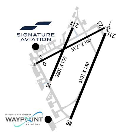
| Rwy | Rwy | |||||||
| 3801x100 | 3801' | 3801x100 | 3801' | |||||
| 6101x150 | 6101' | 6101x150 | 6101' | 110.90 - 205° | ||||
| 5127x100 | 4688' | 5127x100 | 5127' | |||||
| Runway ID | Single Wheel | Double Wheel | Double Tandem Wheel | Dual Double Wheel |
| 03L/21R | 11,000 | N/A | N/A | N/A |
| 03R/21L | 60,000 | 70,000 | 140,000 | N/A |
| 07/25 | 11,000 | 20,000 | 55,000 | N/A |
| These numbers are Advisory and are not limits. The Airport Manager should have more accurate Weight Limits | ||||
 Airport Diagram might not be current. | |
| Facility Name: | CINCINNATI MUNI/LUNKEN FLD |
| City Name: | CINCINNATI |
| County: | HAMILTON |
| State abbrev: | OH |
| State Name: | OHIO |
| Ownership: | PUBLICLY OWNED |
| Use: | OPEN TO THE PUBLIC |
| Owner's Name: | CITY OF CINCINNATI |
| Address: | 262 WILMER AVE |
| CINCINNATI, OH 45226-1679 | |
| Owner's Phone: | 513-321-4132 |
| Manager's Name: | FRED ANDERTON |
| Address: | 262 WILMER AVE |
| CINCINNATI, OH 45226-1679 | |
| Phone: | 513-352-6340 |
| FAA Region: | GREAT LAKES |
| FAA Field Office: | DET |

| Date | Sunrise | Sunset |
|---|---|---|
| 09/24/21 Friday | 7:27 | 19:32 |
| 09/25/21 Saturday | 7:28 | 19:30 |
| 09/26/21 Sunday | 7:29 | 19:29 |
| 09/27/21 Monday | 7:30 | 19:27 |
| 09/28/21 Tuesday | 7:31 | 19:25 |
| 09/29/21 Wednesday | 7:32 | 19:24 |
| 09/30/21 Thursday | 7:32 | 19:22 |
| 10/01/21 Friday | 7:33 | 19:21 |
| 10/02/21 Saturday | 7:34 | 19:19 |
| 10/03/21 Sunday | 7:35 | 19:18 |
| 10/04/21 Monday | 7:36 | 19:16 |
| 10/05/21 Tuesday | 7:37 | 19:14 |
| 10/06/21 Wednesday | 7:38 | 19:13 |
| 10/07/21 Thursday | 7:39 | 19:11 |
| Airport Attendance Schedule | CONTINUOUS |
| Airport Status | OPERATIONAL (This Status can change at any time - please check NOTAMS) |
| Airport Lighting Schedule | WHEN ATCT CLSD ACTVT OR INCR INTST MALSR RWY 21L; HIRL RWY 03R/21L - CTAF. HIRL RWY 03R/21L PRESET MED INTST. RWY 03L/21R & 07/25 PCL UNAVBL. |
| Airport Storage Available | Tie Downs |
| Extra Services Available | Air Ambulance, Avionics, Charter, Flight Instruction, Aircraft Sales |
| Wind Indicator | YES - (lighted) |
| Control Tower | YES |
| CTAF Frequency | 118.700 |
| Unicom Frequency | 122.950 |
| Rotating Beacon Color | CLEAR-GREEN (Light Land Airport); LCTD 1.7 NM E OF ARP. |
| Segmented Circle | NO |
| Landing Fee | YES |
| Airport Inspected | FEDERAL - performed by FAA AIRPORTS FIELD PERSONNEL |
| Inspection Date | 06/27/2019 |
| Type of Fuel Available | Grade 100LL, JET A; -A+A+ C513-871-2020. |
| Airframe Repair Service | MAJOR |
| Power Plant Repair Service | MAJOR |
| Latitude | N3906.2 |
| Longitude | W08425.1 (ESTIMATED) |
| Arpt Elevation | 483ft (SURVEYED) |
| Magnetic Variation | 04W |
| 3 miles SE | of CINCINNATI |
| Traffic Pattern Altitude | |
| Sectional Chart | CINCINNATI |
| Operations (Reported) | Yearly | Avg. Daily |
|---|---|---|
| General Aviation Transient | 40025 | 110 |
| General Aviation Local | 33837 | 93 |
| Air Taxi | 9896 | 27 |
| Commerical | 10 | 0 |
| Commuter | 0 | 0 |
| Military | 234 | 1 |
| Aircraft based on Field | |
|---|---|
| General Aviation Singles | 70 |
| General Aviation Multi | 16 |
| Jet Aircraft | 50 |
| General Aviation Helicopters | 1 |
| Military Aircraft | 0 |
| Gliders | 4 |
| Ultralights | 0 |
| FSS on field | NO |
| FSS tie-in | DAYTON |
| FSS Phone | 1-800-WX-BRIEF |
| Who issues Notams | LUK |
| Notam D service at airport | YES |
| ARTCC Name | INDIANAPOLIS |
| Airport Certification | |
| Aircraft Rescue & Firefighting Index | AIRPORT HAS A CERTIFICATE UNDER CFR PART 139 |
| Airport of Entry | No |
| Custom Landing Rights | YES |
| Joint Civil/Military | No |
| Military Landing rights | YES |
| NATIONAL PLAN OF INTEGRATED AIRPORT SYSTEMS (NPIAS) |
| GRANT AGREEMENTS UNDER FAAP/ADAP/AIP |
| ASSURANCES PURSUANT TO TITLE VI, CIVIL RIGHTS ACT OF 1964 |
| DEER & BIRDS ON & INVOF ARPT. |
| CLSD TO SKEDD ACR OPS GTR THAN 9 PAX SEATS. 48 HR PPR FOR UNSKED ACR OPS WITH GTR THAN 30 PAX SEATS CALL AMGR. |
| NOISE ABATEMENT PROCS IN EFCT CALL AMGR. ACFT MAINT RUNUPS RSTRD BTN 2100-0700. |
| AER 25 & 21L ARE CLOSELY LCTD; VFY COR RWY WITH COMPASS HDG BFR DEP. |
| TWY D, E, G, & H CLSD TO UNSKED ACR OPS GTR THAN 30 PAX SEATS. |
| ARPT SFC COND UNMON DLY 2300-0700, NOV 1-MAR 31. |
| TWY H NOT VSB FM ATCT, CTC GRND CTL. WHEN ATCT CLSD, USE CTAF. |
| RWY 03L/ 21RCLSD TO UNSKED ACR OPS GTR THAN 30 PAX SEATS. |
| RWY 07/2 5 CLSD TO UNSKED ACR OPS GTR THAN 30 PAX SEATS. |
| RWY 03L/ 21RCRACKS & SFC VARNS. |
Airport Communications & Frequencies:
| |||||||||||||||||||||||||||||||
| Runway: 03L | Runway: 21R | ||
| Mag heading: | 27° | Mag heading: | 207° |
| Rwy Slope: | -.13% Down | Rwy Slope: | .13% Up |
| Approach: | Approach: | ||
| Pattern: | Left Traffic | Pattern: | Left Traffic |
| Markings: | BASIC | Markings: | BASIC |
| Marking Condition: | FAIR | Marking Condition: | FAIR |
| Arresting Dev: | Arresting Dev: | ||
| Lat & Long: | N3906.0 W08425.4 | Lat. & Long.: | N3906.6 W08425.1 |
| Elev: | 483.3 ft. MSL | Elev: | 478.4 ft. MSL |
| TCH: | TCH: | 46 ft. AGL | |
| Visual Glide Path: | Visual Glide Path: | 4.00 degrees | |
| Displaced Threshold: | No | Displaced Threshold: | No |
| Touchdown Zone: | YES | Touchdown Zone: | YES |
| Touchdown Elev.: | 483.3 feet | Touchdown Elev.: | 481.1 feet |
| Visual Glide Slope: | Visual Glide Slope: | 4-BOX VASI ON LEFT SIDE OF RUNWAY | |
| RVR Equipment: | RVR Equipment: | ||
| RVV Equipment: | NO | RVV Equipment: | NO |
| Approach Lights: | Approach Lights: | ||
| REIL: | NO | REIL: | NO |
| Centerline Lights: | NO | Centerline Lights: | NO |
| Touchdown lights: | NO | Touchdown lights: | NO |
| Runway Category: | Runway with a Visual Approach | Runway Category: | Runway with a Visual Approach |
| Declared Distances: | Declared Distances: | ||
| Obstructions: | TREES | Obstructions: | PLINE |
| Marked: | NOT Marked/Lighted | Marked: | NOT Marked/Lighted |
| Clearance slope: | 14:1 | Clearance slope: | 41:1 |
| Obstruction height: | 77 feet AGL | Obstruction height: | 52 feet AGL |
| Dist. from runway: | 1307 feet | Dist. from runway: | 2375 feet |
| Centerline offset: | 202 left of centerline | Centerline offset: | 200 feet right of centerline |
| Comments: | Comments: |
| Runway: 03R | Runway: 21L | ||
| Mag heading: | 25° | Mag heading: | 205° |
| Rwy Slope: | -.10% Down | Rwy Slope: | .10% Up |
| Approach: | Approach: | ILS/DME | |
| Pattern: | Left Traffic | Pattern: | Left Traffic |
| Markings: | NONPRECISION INSTRUMENT | Markings: | PRECISION INSTRUMENT |
| Marking Condition: | GOOD | Marking Condition: | GOOD |
| Arresting Dev: | Arresting Dev: | ||
| Lat & Long: | N3905.6 W08425.2 | Lat. & Long.: | N3906.5 W08424.7 |
| Elev: | 481.1 ft. MSL | Elev: | 475.1 ft. MSL |
| TCH: | 44 ft. AGL | TCH: | 39 ft. AGL |
| Visual Glide Path: | 3.00 degrees | Visual Glide Path: | 3.00 degrees |
| Displaced Threshold: | No | Displaced Threshold: | No |
| Touchdown Zone: | YES | Touchdown Zone: | YES |
| Touchdown Elev.: | 481.1 feet | Touchdown Elev.: | 475.2 feet |
| Visual Glide Slope: | 4-Light PAPI on RIGHT side of Runway; UNUSBL BYD 7 DEGS L OF CNTRLN. | Visual Glide Slope: | 4-Light PAPI on LEFT side of Runway |
| RVR Equipment: | ROLLOUT | RVR Equipment: | TOUCHDOWN |
| RVV Equipment: | NO | RVV Equipment: | NO |
| Approach Lights: | Approach Lights: | MALSR - 1,400 foot medium intensity approach lighting system with runway alignment indicator lights | |
| REIL: | YES | REIL: | NO |
| Centerline Lights: | NO | Centerline Lights: | NO |
| Touchdown lights: | NO | Touchdown lights: | NO |
| Runway Category: | Runway with a Non-precision Approach having visibility minimums greater than 3/4 mile | Runway Category: | Precision Instrument Runway |
| Declared Distances: | TORA:6101' TODA:6101' ASDA:6101' LDA:6101' | Declared Distances: | TORA:6101' TODA:6101' ASDA:6101' LDA:6101' |
| Obstructions: | TREE | Obstructions: | TREES |
| Marked: | NOT Marked/Lighted | Marked: | NOT Marked/Lighted |
| Clearance slope: | 24:1 | Clearance slope: | 34:1 |
| Obstruction height: | 78 feet AGL | Obstruction height: | 36 feet AGL |
| Dist. from runway: | 2111 feet | Dist. from runway: | 1427 feet |
| Centerline offset: | 743 right of centerline | Centerline offset: | 320 feet right of centerline |
| Comments: | Comments: |
| Runway: 07 | Runway: 25 | ||
| Mag heading: | 66° | Mag heading: | 246° |
| Rwy Slope: | -.13% Down | Rwy Slope: | .13% Up |
| Approach: | Approach: | ||
| Pattern: | Left Traffic | Pattern: | Left Traffic |
| Markings: | NONPRECISION INSTRUMENT | Markings: | NONPRECISION INSTRUMENT |
| Marking Condition: | FAIR | Marking Condition: | FAIR |
| Arresting Dev: | Arresting Dev: | ||
| Lat & Long: | N3906.2 W08425.7 | Lat. & Long.: | N3906.6 W08424.7 |
| Elev: | 481.5 ft. MSL | Elev: | 474.9 ft. MSL |
| TCH: | TCH: | 40 ft. AGL | |
| Visual Glide Path: | Visual Glide Path: | 3.00 degrees | |
| Displaced Threshold: | 439 feet | Displaced Threshold: | No |
| Touchdown Zone: | YES | Touchdown Zone: | YES |
| Touchdown Elev.: | 481.6 feet | Touchdown Elev.: | 477.8 feet |
| Visual Glide Slope: | Visual Glide Slope: | 4-BOX VASI ON LEFT SIDE OF RUNWAY | |
| RVR Equipment: | RVR Equipment: | ||
| RVV Equipment: | NO | RVV Equipment: | NO |
| Approach Lights: | Approach Lights: | ||
| REIL: | NO | REIL: | NO |
| Centerline Lights: | NO | Centerline Lights: | NO |
| Touchdown lights: | NO | Touchdown lights: | NO |
| Runway Category: | Runway with a Visual Approach | Runway Category: | Runway with a Non-precision Approach having visibility minimums greater than 3/4 mile |
| Declared Distances: | Declared Distances: | ||
| Obstructions: | TREE | Obstructions: | |
| Marked: | NOT Marked/Lighted | Marked: | |
| Clearance slope: | 12:1; 23:1 TO DTHR. | Clearance slope: | 34:1 |
| Obstruction height: | 59 feet AGL | Obstruction height: | |
| Dist. from runway: | 920 feet | Dist. from runway: | |
| Centerline offset: | 50 left of centerline | Centerline offset: | |
| Comments: | HANGAR & PARKED ACFT; +36 FT ANT ON HANGAR, 177 FT DIST TO THR, 615 FT DIST TO DTHR, 157 FT R OF CNTRLN. APCH RATIO 0:1 TO THR; APCH RATIO 11:1 TO DTHR. | Comments: |
Thanks for using FltPlan.com
all rights reserved © 1999-2021 by Flight Plan LLC