
| LAWSON AAF (FORT BENNING) FORT BENNING(COLUMBU GA |
| |
| Lat: N 3219.9 Long: W 08459.2 Elev: 227 Var: +02 Longest Runway: 10002 | ||
| Clr Del: 121.7 Dept. ATIS: 134.37 Arr. ATIS: 134.37 Ground: 121.7 Tower: 119.05 | ||
| ||||||
|
| Rwy | Rwy | |||||||
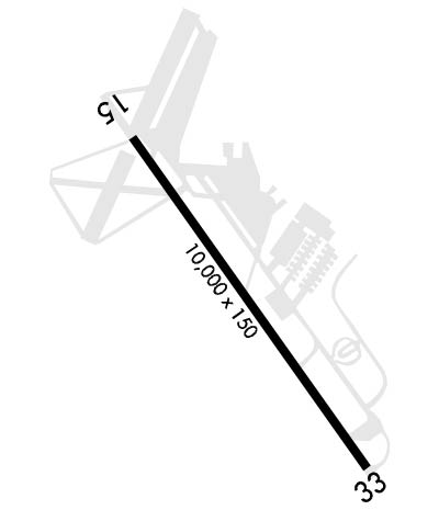
| 10002x150 | 10002' | 10002x150 | 9302' | 110.70 - 326° | ||||
| Runway ID | Single Wheel | Double Wheel | Double Tandem Wheel | Dual Double Wheel |
| 15/33 | N/A | N/A | N/A | N/A |
| These numbers are Advisory and are not limits. The Airport Manager should have more accurate Weight Limits | ||||
 Airport Diagram might not be current. | |
| Facility Name: | LAWSON AAF (FORT BENNING) |
| City Name: | FORT BENNING(COLUMBUS) |
| County: | CHATTAHOOCHEE |
| State abbrev: | GA |
| State Name: | GEORGIA |
| Ownership: | ARMY OWNED |
| Use: | PRIVATE |
| Owner's Name: | US ARMY ATCA-ASO |
| Address: | 9325 GUNSTON ROAD |
| FT BELVOIR, VA 22060 | |
| Owner's Phone: | 703-274-7773 |
| Manager's Name: | COMMANDER USAASA |
| Address: | 9325 GUNSTON RD BLDG 1466 STE N319 |
| FT BELVOIR, VA 22060 | |
| Phone: | |
| FAA Region: | SOUTHERN |
| FAA Field Office: | ATL |
| Date | Sunrise | Sunset |
|---|---|---|
| 09/24/21 Friday | 7:29 | 19:34 |
| 09/25/21 Saturday | 7:30 | 19:33 |
| 09/26/21 Sunday | 7:31 | 19:32 |
| 09/27/21 Monday | 7:31 | 19:30 |
| 09/28/21 Tuesday | 7:32 | 19:29 |
| 09/29/21 Wednesday | 7:32 | 19:28 |
| 09/30/21 Thursday | 7:33 | 19:26 |
| 10/01/21 Friday | 7:34 | 19:25 |
| 10/02/21 Saturday | 7:34 | 19:24 |
| 10/03/21 Sunday | 7:35 | 19:22 |
| 10/04/21 Monday | 7:36 | 19:21 |
| 10/05/21 Tuesday | 7:36 | 19:20 |
| 10/06/21 Wednesday | 7:37 | 19:19 |
| 10/07/21 Thursday | 7:38 | 19:17 |
| Airport Attendance Schedule | CONTINUOUS |
| Airport Status | OPERATIONAL (This Status can change at any time - please check NOTAMS) |
| Airport Lighting Schedule | |
| Airport Storage Available | NONE |
| Extra Services Available | NONE |
| Wind Indicator | NONE |
| Control Tower | YES |
| CTAF Frequency | 119.050 |
| Unicom Frequency | |
| Rotating Beacon Color | SPLIT-CLEAR-GREEN (LIGHTED MILITARY AIRPORT) |
| Segmented Circle | NO |
| Landing Fee |
| Airport Inspected | No Inspection Data Available performed by the OWNER |
| Inspection Date | Unknown |
| Type of Fuel Available | JET A (freeze point -40C) |
| Airframe Repair Service | None |
| Power Plant Repair Service | None |
| Latitude | N3219.9 |
| Longitude | W08459.2 (ESTIMATED) |
| Arpt Elevation | 227ft (SURVEYED) |
| Magnetic Variation | 02W |
| 5 miles SW | of FORT BENNING(COLUMBUS) |
| Traffic Pattern Altitude | TPA: FIXED WING ACFT 1800 FT, 360 DEG OVHD 2300 FT, ROTARY WING 1000 FT. |
| Sectional Chart | ATLANTA |
| Operations (Reported) | Yearly | Avg. Daily |
|---|---|---|
| General Aviation Transient | 0 | 0 |
| General Aviation Local | 0 | 0 |
| Air Taxi | 0 | 0 |
| Commerical | 0 | 0 |
| Commuter | 0 | 0 |
| Military | 0 | 0 |
| Aircraft based on Field | |
|---|---|
| General Aviation Singles | 0 |
| General Aviation Multi | 0 |
| Jet Aircraft | 0 |
| General Aviation Helicopters | 0 |
| Military Aircraft | 0 |
| Gliders | 0 |
| Ultralights | 0 |
| FSS on field | NO |
| FSS tie-in | MACON |
| FSS Phone | 1-800-WX-BRIEF |
| Who issues Notams | LSF |
| Notam D service at airport | YES |
| ARTCC Name | ATLANTA |
| Airport Certification | |
| Aircraft Rescue & Firefighting Index | None |
| Airport of Entry | No |
| Custom Landing Rights | No |
| Joint Civil/Military | No |
| Military Landing rights | No |
| MISC: VIP ACFT CTC PTD 45 NM OUT. LSF-BENN.DOT.LS.-OPS@BENNING.ARMY.MIL |
| RADAR: SEE TERMINAL FLIP FOR RADAR MINIMA. |
| ADV SVC RQSTS ON BASE OPS FREQS WHEN ATCT CLSD. |
| RSTD: 72 HR PPR RQR FOR ALL TRAN ACFT INCL TGL EXC AIREVAC 24 HR PPR RECOMMENDED. CIV ACFT LDG PERMIT MANDATORY FOR ALL NON DOD GOV ACFT. CTC BASOPS FOR PPR DSN 835 3524, C706-545-3524. |
| EXTENSIVE TROOP CARRIER OPR. PARACHUTE DROPS AT 1550 FT WITHIN 3.5 NM OF ARPT. EXTENSIVE HELICOPTER OPR. |
| TFC PAT: RESTRICTED TO THE WEST OF RY. |
| MISC: WX OBS AUTOMATED AND AUGMENTED AS REQUIRED FOR CONTINUOUS OPERATION. REMOTE BRIEFING SVCS AVBL 26 OWS, BARKSDALE AFB, DSN 331-2651/2652/2653 COM 318-529-2651/2652/2653, TOLL FREE 1-866-223-9328, FAX DSN 331-2609; HTTPS://26OWS.US.AF.MIL. WX FORECASTER ON DUTY 1200Z-0400Z++ MON-FRI, EXC HOL. |
| MISC: VIP ACFT CTC PTD 45 NM OUT. |
| MISC: WHEN TWR CLOSED, CTC AIRPORT ADVISORY SERVICE ON TWR FREQ. LAVATORY AND AIRCRAFT CLEANING SERVICES NOT AVAILABLE. |
| MISC: NO CUSTOMS SERVICES AVAILABLE. |
| SERVICE-LGT-UNMTO WHEN ALFD CLSD. AFLD OPS LTD TO TENANT ACFT WHEN AFLD CLSD. |
| NAVAIDS UNMON WHEN TAF CLSD |
| OPR 1230-0400Z++ MON-FRI, EXC HOL. MISC- AFLD OPS LTD TO TENANT ACFT WHEN TAF CLSD. TENANT ACFT CONDUCTING TACTICAL OPS ON KLSF CTC LAWSON ON CTAF WHEN TWR CLSD. |
| CAUTION: SOLAR PANEL FARM LCT 1.5 MILES S OF RWY 33 THLD. ALL ACFT OVFT OF SOLAR FARM WILL BE AT OR ABV 500 FT. AGL. |
| RSTD: 7 DAY PPR FOR HAZ CARGO. |
| TWY H 50 FT WIDE. |
| JASU: 2(MA32A-95) |
| A++ REFUEL SVC AVBL MON-FRI 1230-0400Z++, MON-FRI EXC HOL: OT 72 HR PPR RQR. |
| OIL: O-128-148-156 |
| TRAN ALERT: ++ SVC MON-FRI 1230-0400Z++, EXC HOL, OT 72 HR PPR RQR. |
Airport Communications & Frequencies:
| |||||||||||||||||||||||||||||||||||||||||||
| Runway: 15 | Runway: 33 | ||
| Mag heading: | N/A | Mag heading: | N/A |
| Rwy Slope: | .00% Down | Rwy Slope: | .00% Up |
| Approach: | Approach: | ILS | |
| Pattern: | Right Traffic | Pattern: | Left Traffic |
| Markings: | Markings: | ||
| Marking Condition: | Marking Condition: | ||
| Arresting Dev: | Arresting Dev: | ||
| Lat & Long: | N3220.6 W08459.8 | Lat. & Long.: | N3219.2 W08458.7 |
| Elev: | 226.7 ft. MSL | Elev: | 226.3 ft. MSL |
| TCH: | 55 ft. AGL | TCH: | 55 ft. AGL |
| Visual Glide Path: | 3.00 degrees | Visual Glide Path: | 3.00 degrees |
| Displaced Threshold: | No | Displaced Threshold: | 700 feet |
| Touchdown Zone: | YES | Touchdown Zone: | YES |
| Touchdown Elev.: | 226.9 feet | Touchdown Elev.: | 227.0 feet |
| Visual Glide Slope: | 4-Light PAPI on LEFT side of Runway | Visual Glide Slope: | 4-Light PAPI on LEFT side of Runway |
| RVR Equipment: | RVR Equipment: | ||
| RVV Equipment: | NO | RVV Equipment: | NO |
| Approach Lights: | Approach Lights: | SALSF | |
| REIL: | NO | REIL: | NO |
| Centerline Lights: | NO | Centerline Lights: | NO |
| Touchdown lights: | NO | Touchdown lights: | NO |
| Runway Category: | Runway with a Visual Approach | Runway Category: | Runway with a Visual Approach |
| Declared Distances: | TORA:10002' TODA:10002' ASDA:10002' LDA:10002' | Declared Distances: | TORA:10002' TODA:10002' ASDA:10002' LDA:9302' |
Thanks for using FltPlan.com
all rights reserved © 1999-2021 by Flight Plan LLC
