
| LAS CRUCES INTL LAS CRUCES NM |
| |
| Lat: N 3217.4 Long: W 10655.3 Elev: 4457 Var: -08 Longest Runway: 7506 | ||
| AWOS: 119.02 CTAF: 122.7 | ||
| ||||||||||||||||||||||||||||||||||||||||||||||||||||||||||||||||||||
| ||||||||||||||||||||||||||||||||||||||||||||||||||||||||||||||||||||
| ||||||||||||||||||||||||||||||||||||||||||||||||||||||||||||||||||||
| ||||||||||||||||||||||||||||||||||||||||||||||||||||||||||||||||||||
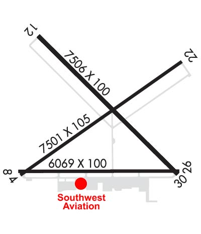
| Rwy | Rwy | |||||||
| 7501x105 | 7501' | 7501x105 | 7501' | |||||
| 6069x100 | 6069' | 6069x100 | 6069' | |||||
| 7506x100 | 7506' | 7506x100 | 7506' | 109.30 - 307° | ||||
| Runway ID | Single Wheel | Double Wheel | Double Tandem Wheel | Dual Double Wheel |
| 04/22 | 30,000 | 30,000 | 30,000 | 30,000 |
| 08/26 | 70,000 | 120,000 | N/A | N/A |
| 12/30 | 70,000 | 120,000 | N/A | N/A |
| These numbers are Advisory and are not limits. The Airport Manager should have more accurate Weight Limits | ||||
 Airport Diagram might not be current. | |
| Facility Name: | LAS CRUCES INTL |
| City Name: | LAS CRUCES |
| County: | DONA ANA |
| State abbrev: | NM |
| State Name: | NEW MEXICO |
| Ownership: | PUBLICLY OWNED |
| Use: | OPEN TO THE PUBLIC |
| Owner's Name: | CITY OF LAS CRUCES |
| Address: | PO BOX 20000 |
| LAS CRUCES, NM 88004 | |
| Owner's Phone: | (575) 541-2471 |
| Manager's Name: | ANDY HUME |
| Address: | PO BOX 20000 |
| LAS CRUCES, NM 88004 | |
| Phone: | (575) 541-2473 |
| FAA Region: | SOUTHWEST |
| FAA Field Office: | LNM |
| Date | Sunrise | Sunset |
|---|---|---|
| 09/24/21 Friday | 6:57 | 19:02 |
| 09/25/21 Saturday | 6:58 | 19:01 |
| 09/26/21 Sunday | 6:58 | 18:59 |
| 09/27/21 Monday | 6:59 | 18:58 |
| 09/28/21 Tuesday | 7:00 | 18:57 |
| 09/29/21 Wednesday | 7:00 | 18:55 |
| 09/30/21 Thursday | 7:01 | 18:54 |
| 10/01/21 Friday | 7:02 | 18:53 |
| 10/02/21 Saturday | 7:02 | 18:51 |
| 10/03/21 Sunday | 7:03 | 18:50 |
| 10/04/21 Monday | 7:04 | 18:49 |
| 10/05/21 Tuesday | 7:04 | 18:48 |
| 10/06/21 Wednesday | 7:05 | 18:46 |
| 10/07/21 Thursday | 7:06 | 18:45 |
| Airport Attendance Schedule | CONTINUOUS |
| Airport Status | OPERATIONAL (This Status can change at any time - please check NOTAMS) |
| Airport Lighting Schedule | ACTVT MIRL RY 04/22, HIRL RY 12/30 AND MALSR RY 30 - CTAF. MIRL RY 08/26 PRESET LOW INTST; TO INCR INTST ACTVT - CTAF. REIL RY 12 OPERATES SS-SR. PAPI RWY 08, 26 & VASI RWY 22 OPERATES CONTINOUSLY. |
| Airport Storage Available | Tie Downs, Hanger |
| Extra Services Available | Air Freight, Air Ambulance, Flight Instruction, Aircraft Rental |
| Wind Indicator | YES - (lighted) |
| Control Tower | NO |
| CTAF Frequency | 122.700 |
| Unicom Frequency | 122.700 |
| Rotating Beacon Color | CLEAR-GREEN (Light Land Airport) |
| Segmented Circle | YES |
| Landing Fee | NO |
| Airport Inspected | FEDERAL - performed by FAA AIRPORTS FIELD PERSONNEL |
| Inspection Date | 10/30/2020 |
| Type of Fuel Available | Grade 100LL, JET A-1 (icing inhibitor, freeze point -50C) |
| Airframe Repair Service | MAJOR |
| Power Plant Repair Service | MAJOR |
| Latitude | N3217.4 |
| Longitude | W10655.3 (ESTIMATED) |
| Arpt Elevation | 4456ft (SURVEYED) |
| Magnetic Variation | 08E |
| 8 miles W | of LAS CRUCES |
| Traffic Pattern Altitude | |
| Sectional Chart | ALBUQUERQUE |
| Operations (Reported) | Yearly | Avg. Daily |
|---|---|---|
| General Aviation Transient | 10658 | 29 |
| General Aviation Local | 12180 | 33 |
| Air Taxi | 3634 | 10 |
| Commerical | 0 | 0 |
| Commuter | 0 | 0 |
| Military | 10353 | 28 |
| Aircraft based on Field | |
|---|---|
| General Aviation Singles | 82 |
| General Aviation Multi | 10 |
| Jet Aircraft | 2 |
| General Aviation Helicopters | 3 |
| Military Aircraft | 4 |
| Gliders | 4 |
| Ultralights | 1 |
| FSS on field | NO |
| FSS tie-in | ALBUQUERQUE |
| FSS Phone | 1-800-WX-BRIEF |
| Who issues Notams | LRU |
| Notam D service at airport | YES |
| ARTCC Name | ALBUQUERQUE |
| Airport Certification | PPR 48 HRS FOR ACR ACFT WITH MORE THAN 30 PSGR SEATS CALL AMGR 575-541-2471 OR 575-541-2473. |
| Aircraft Rescue & Firefighting Index | AIRPORT HAS A CERTIFICATE UNDER CFR PART 139 |
| Airport of Entry | No |
| Custom Landing Rights | No |
| Joint Civil/Military | No |
| Military Landing rights | YES |
| NATIONAL PLAN OF INTEGRATED AIRPORT SYSTEMS (NPIAS) |
| GRANT AGREEMENTS UNDER FAAP/ADAP/AIP |
| SURPLUS PROPERTY AGREEMENT UNDER PUBLIC LAW 289 |
| CONVEYANCE UNDER SCETION 16, FEDERAL AIRPORT ACT OF 1946 OR SECTION 23, AIRPORT AND AIRWAY DEVELOPMENT ACT OF 1970 |
| ASSURANCES PURSUANT TO TITLE VI, CIVIL RIGHTS ACT OF 1964 |
| AGREEMENT UNDER DLAND OR DCLA HAS EXPIRED. |
| RY 30 DESIGNATED CALM WIND RY. |
| BIRDS ON & INVOF ARPT SEP-MAR. |
| RY 04/22 NOT AVBL FOR ACR OPNS. |
| UNMANNED AERIAL VEHICLE TRAINING OPERATIONS ON THE AIRPORT. |
| RY 04/22 CLSD TO ACFT OVER 30,000 LBS. |
| FOR CD CTC ALBUQUERQUE ARTCC AT 505-856-4861. |
| RWY 04/2 2 SLABS HAVE CRACKS. SOME CRACKS OPEN ONE-EIGTH INCH. SOME HAVE SPALLING SEALANT FAILURE IN MULTIPLE JOINTS. |
Airport Communications & Frequencies:
| |||||||||
| Runway: 04 | Runway: 22 | ||
| Mag heading: | 47° | Mag heading: | 227° |
| Rwy Slope: | .21% Up | Rwy Slope: | -.21% Down |
| Approach: | Approach: | ||
| Pattern: | Left Traffic | Pattern: | Left Traffic |
| Markings: | BASIC | Markings: | BASIC |
| Marking Condition: | FAIR | Marking Condition: | FAIR |
| Arresting Dev: | Arresting Dev: | ||
| Lat & Long: | N3217.1 W10655.9 | Lat. & Long.: | N3217.8 W10654.7 |
| Elev: | 4435.9 ft. MSL | Elev: | 4451.7 ft. MSL |
| TCH: | TCH: | 64 ft. AGL | |
| Visual Glide Path: | Visual Glide Path: | 3.00 degrees | |
| Displaced Threshold: | No | Displaced Threshold: | No |
| Touchdown Zone: | YES | Touchdown Zone: | YES |
| Touchdown Elev.: | 4444.0 feet | Touchdown Elev.: | 4451.7 feet |
| Visual Glide Slope: | Visual Glide Slope: | 4-BOX VASI ON LEFT SIDE OF RUNWAY | |
| RVR Equipment: | RVR Equipment: | ||
| RVV Equipment: | NO | RVV Equipment: | NO |
| Approach Lights: | Approach Lights: | ||
| REIL: | NO | REIL: | NO |
| Centerline Lights: | NO | Centerline Lights: | NO |
| Touchdown lights: | NO | Touchdown lights: | NO |
| Runway Category: | Runway with a Visual Approach | Runway Category: | Runway with a Visual Approach |
| Declared Distances: | TORA:7499' TODA:7499' ASDA:7499' LDA:7499' | Declared Distances: | TORA:7499' TODA:7499' ASDA:7499' LDA:7499' |
| Runway: 08 | Runway: 26 | ||
| Mag heading: | 82° | Mag heading: | 262° |
| Rwy Slope: | -.01% Down | Rwy Slope: | .01% Up |
| Approach: | Approach: | ||
| Pattern: | Left Traffic | Pattern: | Left Traffic |
| Markings: | BASIC | Markings: | BASIC |
| Marking Condition: | GOOD | Marking Condition: | FAIR |
| Arresting Dev: | Arresting Dev: | ||
| Lat & Long: | N3217.1 W10655.9 | Lat. & Long.: | N3217.1 W10654.8 |
| Elev: | 4436.5 ft. MSL | Elev: | 4435.9 ft. MSL |
| TCH: | 50 ft. AGL | TCH: | 50 ft. AGL |
| Visual Glide Path: | 3.00 degrees | Visual Glide Path: | 3.00 degrees |
| Displaced Threshold: | No | Displaced Threshold: | No |
| Touchdown Zone: | YES | Touchdown Zone: | YES |
| Touchdown Elev.: | 4438.2 feet | Touchdown Elev.: | 4435.9 feet |
| Visual Glide Slope: | 4-Light PAPI on LEFT side of Runway | Visual Glide Slope: | 4-Light PAPI on LEFT side of Runway |
| RVR Equipment: | RVR Equipment: | ||
| RVV Equipment: | NO | RVV Equipment: | NO |
| Approach Lights: | Approach Lights: | ||
| REIL: | NO | REIL: | NO |
| Centerline Lights: | NO | Centerline Lights: | NO |
| Touchdown lights: | NO | Touchdown lights: | NO |
| Runway Category: | Runway with a Visual Approach | Runway Category: | Runway with a Visual Approach |
| Declared Distances: | TORA:6069' TODA:6069' ASDA:6069' LDA:6069' | Declared Distances: | TORA:6069' TODA:6069' ASDA:6069' LDA:6069' |
| Runway: 12 | Runway: 30 | ||
| Mag heading: | 127° | Mag heading: | 307° |
| Rwy Slope: | -.28% Down | Rwy Slope: | .28% Up |
| Approach: | Approach: | ILS/DME | |
| Pattern: | Left Traffic | Pattern: | Left Traffic |
| Markings: | NONPRECISION INSTRUMENT | Markings: | PRECISION INSTRUMENT |
| Marking Condition: | GOOD | Marking Condition: | GOOD |
| Arresting Dev: | Arresting Dev: | ||
| Lat & Long: | N3218.0 W10655.8 | Lat. & Long.: | N3217.1 W10654.8 |
| Elev: | 4456.9 ft. MSL | Elev: | 4435.9 ft. MSL |
| TCH: | TCH: | ||
| Visual Glide Path: | Visual Glide Path: | ||
| Displaced Threshold: | No | Displaced Threshold: | No |
| Touchdown Zone: | YES | Touchdown Zone: | YES |
| Touchdown Elev.: | 4456.9 feet | Touchdown Elev.: | 4443.7 feet |
| Visual Glide Slope: | Visual Glide Slope: | ||
| RVR Equipment: | RVR Equipment: | ||
| RVV Equipment: | NO | RVV Equipment: | NO |
| Approach Lights: | Approach Lights: | MALSR - 1,400 foot medium intensity approach lighting system with runway alignment indicator lights | |
| REIL: | YES | REIL: | NO |
| Centerline Lights: | NO | Centerline Lights: | NO |
| Touchdown lights: | NO | Touchdown lights: | NO |
| Runway Category: | Runway with a Visual Approach | Runway Category: | Precision Instrument Runway |
| Declared Distances: | TORA:7499' TODA:7499' ASDA:7499' LDA:7499' | Declared Distances: | TORA:7499' TODA:7499' ASDA:7499' LDA:7499' |
Thanks for using FltPlan.com
all rights reserved © 1999-2021 by Flight Plan LLC


