| LEWIS UNIVERSITY CHICAGO/ROMEOVILLE IL |
| |
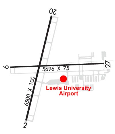
| Lat: N 4136.5 Long: W 08805.8 Elev: 679 Var: +02 Longest Runway: 6500 | ||
| AWOS: 118.52 CTAF: 122.8 | ||
| ||||||||||||||||||||||||||||||||||||||||||||||||||||||||||||||||||||
| ||||||||||||||||||||||||||||||||||||||||||||||||||||||||||||||||||||
| ||||||||||||||||||||||||||||||||||||||||||||||||||||||||||||||||||||
| Rwy | Rwy | |||||||
| 6500x100 | 6500' | 108.55 - 015° | 6500x100 | 6500' | ||||
| 5500x75 | 5500' | 111.95 - 089° | 5500x75 | 5500' | ||||
| Runway ID | Single Wheel | Double Wheel | Double Tandem Wheel | Dual Double Wheel |
| 02/20 | N/A | 99,000 | N/A | N/A |
| 09/27 | 20,000 | 75,000 | N/A | N/A |
| These numbers are Advisory and are not limits. The Airport Manager should have more accurate Weight Limits | ||||
 Airport Diagram might not be current. | |
| Facility Name: | LEWIS UNIVERSITY |
| City Name: | CHICAGO/ROMEOVILLE |
| County: | WILL |
| State abbrev: | IL |
| State Name: | ILLINOIS |
| Ownership: | PUBLICLY OWNED |
| Use: | OPEN TO THE PUBLIC |
| Owner's Name: | JOLIET REGIONAL PORT DIST |
| Address: | #1 EXECUTIVE TERMINAL, GEORGE MICHAS DRIVE |
| ROMEOVILLE, IL 60446-7175 | |
| Owner's Phone: | 815-838-9497 |
| Manager's Name: | CHRIS LAWSON |
| Address: | #1 EXECUTVE TERMINAL, GEORGE MICHAS DRIVE; EAMIL ADDRESS: CLAWSON@FLYLOT.COM (ALL LOWER CASE) |
| ROMEOVILLE, IL 60446-7175 | |
| Phone: | 815-838-9497; AMGR ADDNL PHONE NUMBER - 815-838-9512. |
| FAA Region: | GREAT LAKES |
| FAA Field Office: | CHI |

| Date | Sunrise | Sunset |
|---|---|---|
| 09/24/21 Friday | 6:42 | 18:47 |
| 09/25/21 Saturday | 6:43 | 18:45 |
| 09/26/21 Sunday | 6:44 | 18:43 |
| 09/27/21 Monday | 6:45 | 18:41 |
| 09/28/21 Tuesday | 6:46 | 18:40 |
| 09/29/21 Wednesday | 6:47 | 18:38 |
| 09/30/21 Thursday | 6:48 | 18:36 |
| 10/01/21 Friday | 6:49 | 18:35 |
| 10/02/21 Saturday | 6:50 | 18:33 |
| 10/03/21 Sunday | 6:51 | 18:31 |
| 10/04/21 Monday | 6:52 | 18:29 |
| 10/05/21 Tuesday | 6:53 | 18:28 |
| 10/06/21 Wednesday | 6:54 | 18:26 |
| 10/07/21 Thursday | 6:55 | 18:24 |
| Airport Attendance Schedule | 7 Days A Week 0700-2100 |
| Airport Status | OPERATIONAL (This Status can change at any time - please check NOTAMS) |
| Airport Lighting Schedule | MIRL RY 02/20 & 09/27 PRESET ON LOW INTST; TO INCR INTST ACTVT - CTAF. ACTVT REIL RYS 02/20 & 09/27 & PAPI RYS 02/ 20 & 09/27 - CTAF. |
| Airport Storage Available | Tie Downs, Hanger |
| Extra Services Available | Flight Instruction, Aircraft Rental, Aircraft Sales |
| Wind Indicator | YES - (lighted) |
| Control Tower | NO |
| CTAF Frequency | 122.800 |
| Unicom Frequency | 122.800 |
| Rotating Beacon Color | CLEAR-GREEN (Light Land Airport) |
| Segmented Circle | NO |
| Landing Fee | NO |
| Airport Inspected | STATE - performed by STATE AERONAUTICAL PERSONNEL |
| Inspection Date | 08/30/2019 |
| Type of Fuel Available | Grade 100LL, JET A (freeze point -40C) |
| Airframe Repair Service | MAJOR |
| Power Plant Repair Service | MAJOR |
| Latitude | N4136.5 |
| Longitude | W08805.8 (ESTIMATED) |
| Arpt Elevation | 679ft (SURVEYED) |
| Magnetic Variation | 02W |
| 20 miles SW | of CHICAGO/ROMEOVILLE |
| Traffic Pattern Altitude | |
| Sectional Chart | CHICAGO |
| Operations (Reported) | Yearly | Avg. Daily |
|---|---|---|
| General Aviation Transient | 40000 | 110 |
| General Aviation Local | 60000 | 164 |
| Air Taxi | 4000 | 11 |
| Commerical | 0 | 0 |
| Commuter | 0 | 0 |
| Military | 0 | 0 |
| Aircraft based on Field | |
|---|---|
| General Aviation Singles | 108 |
| General Aviation Multi | 11 |
| Jet Aircraft | 8 |
| General Aviation Helicopters | 7 |
| Military Aircraft | 0 |
| Gliders | 0 |
| Ultralights | 0 |
| FSS on field | NO |
| FSS tie-in | KANKAKEE |
| FSS Phone | 1-800-WX-BRIEF |
| Who issues Notams | LOT |
| Notam D service at airport | YES |
| ARTCC Name | CHICAGO |
| Airport Certification | |
| Aircraft Rescue & Firefighting Index | None |
| Airport of Entry | No |
| Custom Landing Rights | No |
| Joint Civil/Military | No |
| Military Landing rights | No |
| NATIONAL PLAN OF INTEGRATED AIRPORT SYSTEMS (NPIAS) |
| N PARKING RAMP CLSD TO ALL MULTI ENGINE ACFT. |
| BIRDS ON & INVOF ARPT. |
| CHICAGO APPROACH CLEARANCE 847-289-0926 |
| FOR CD CTC CHICAGO APCH AT 847-289-0926. |
| TWYS N1 AND N2 CLSD TO FIXED WING ACFT MORE THAN 6000LB. |
| BA CONDS ARE NOT RPRTD BTN 2100 - 0600. |
Airport Communications & Frequencies:
| ||||||||||||||
| Runway: 02 | Runway: 20 | ||
| Mag heading: | 15° | Mag heading: | 195° |
| Rwy Slope: | -.20% Down | Rwy Slope: | .20% Up |
| Approach: | LOC/DME | Approach: | |
| Pattern: | Left Traffic | Pattern: | Left Traffic |
| Markings: | NONPRECISION INSTRUMENT | Markings: | NONPRECISION INSTRUMENT |
| Marking Condition: | GOOD | Marking Condition: | GOOD |
| Arresting Dev: | Arresting Dev: | ||
| Lat & Long: | N4136.0 W08806.1 | Lat. & Long.: | N4137.0 W08805.7 |
| Elev: | 679.0 ft. MSL | Elev: | 665.9 ft. MSL |
| TCH: | 37 ft. AGL | TCH: | 40 ft. AGL |
| Visual Glide Path: | 3.00 degrees | Visual Glide Path: | 3.20 degrees |
| Displaced Threshold: | No | Displaced Threshold: | No |
| Touchdown Zone: | YES | Touchdown Zone: | YES |
| Touchdown Elev.: | 679.0 feet | Touchdown Elev.: | 667.9 feet |
| Visual Glide Slope: | 4-Light PAPI on LEFT side of Runway | Visual Glide Slope: | 4-Light PAPI on LEFT side of Runway |
| RVR Equipment: | RVR Equipment: | ||
| RVV Equipment: | NO | RVV Equipment: | NO |
| Approach Lights: | Approach Lights: | ||
| REIL: | YES | REIL: | YES |
| Centerline Lights: | NO | Centerline Lights: | NO |
| Touchdown lights: | NO | Touchdown lights: | NO |
| Runway Category: | D | Runway Category: | Runway with a Non-precision Approach having visibility minimums greater than 3/4 mile |
| Declared Distances: | Declared Distances: |
| Runway: 09 | Runway: 27 | ||
| Mag heading: | 90° | Mag heading: | 270° |
| Rwy Slope: | -.13% Down | Rwy Slope: | .13% Up |
| Approach: | LOC/DME | Approach: | |
| Pattern: | Left Traffic | Pattern: | Left Traffic |
| Markings: | NONPRECISION INSTRUMENT | Markings: | NONPRECISION INSTRUMENT |
| Marking Condition: | GOOD | Marking Condition: | GOOD |
| Arresting Dev: | Arresting Dev: | ||
| Lat & Long: | N4136.5 W08806.3 | Lat. & Long.: | N4136.5 W08805.1 |
| Elev: | 673.1 ft. MSL | Elev: | 665.8 ft. MSL |
| TCH: | 41 ft. AGL | TCH: | 35 ft. AGL |
| Visual Glide Path: | 3.00 degrees | Visual Glide Path: | 3.00 degrees |
| Displaced Threshold: | No | Displaced Threshold: | No |
| Touchdown Zone: | YES | Touchdown Zone: | YES |
| Touchdown Elev.: | 673.1 feet | Touchdown Elev.: | 668.2 feet |
| Visual Glide Slope: | 4-Light PAPI on LEFT side of Runway | Visual Glide Slope: | 4-Light PAPI on LEFT side of Runway |
| RVR Equipment: | RVR Equipment: | ||
| RVV Equipment: | NO | RVV Equipment: | NO |
| Approach Lights: | Approach Lights: | ||
| REIL: | YES | REIL: | YES |
| Centerline Lights: | NO | Centerline Lights: | NO |
| Touchdown lights: | NO | Touchdown lights: | NO |
| Runway Category: | Runway with a Non-precision Approach | Runway Category: | Runway with a Non-precision Approach |
| Declared Distances: | Declared Distances: |
Thanks for using FltPlan.com
all rights reserved © 1999-2021 by Flight Plan LLC