| TRI-COUNTY RGNL LONE ROCK WI |
| |
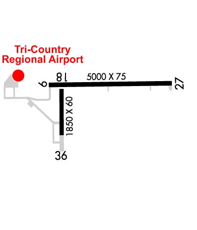
| Lat: N 4312.7 Long: W 09010.8 Elev: 717 Var: -00 Longest Runway: 5000 | ||
| AWOS: 119.42 CTAF: 123.0 | ||
| |||||||||||||||||||||||||||||||||||||||||||||||||||||||||||||
| |||||||||||||||||||||||||||||||||||||||||||||||||||||||||||||
| |||||||||||||||||||||||||||||||||||||||||||||||||||||||||||||
| Rwy | Rwy | |||||||
| 5000x75 | 5000' | 5000x75 | 5000' | 108.35 - 270° | ||||
| 1850x60 | 1850' | 1850x60 | 1850' | |||||
| Runway ID | Single Wheel | Double Wheel | Double Tandem Wheel | Dual Double Wheel |
| 09/27 | 12,500 | N/A | N/A | N/A |
| 18/36 | 12,500 | N/A | N/A | N/A |
| These numbers are Advisory and are not limits. The Airport Manager should have more accurate Weight Limits | ||||
 Airport Diagram might not be current. | |
| Facility Name: | TRI-COUNTY RGNL |
| City Name: | LONE ROCK |
| County: | SAUK |
| State abbrev: | WI |
| State Name: | WISCONSIN |
| Ownership: | PUBLICLY OWNED |
| Use: | OPEN TO THE PUBLIC |
| Owner's Name: | SAUK & RICHLAND COUNTIES |
| Address: | 181 W SEMINARY ST |
| RICHLAND CENTER, WI 53581 | |
| Owner's Phone: | 608-649-3001 |
| Manager's Name: | MARK HIGGS |
| Address: | E2525 CO. HWY JJ; EMAIL ADDRESS: MARKHIGGSTCA@YAHOO.COM (ALL LOWER CASE) |
| SPRING GREEN, WI 53588 | |
| Phone: | 608-583-2600 |
| FAA Region: | GREAT LAKES |
| FAA Field Office: | CHI |
| Date | Sunrise | Sunset |
|---|---|---|
| 06/12/26 Friday | 5:20 | 20:41 |
| 06/13/26 Saturday | 5:20 | 20:41 |
| 06/14/26 Sunday | 5:20 | 20:42 |
| 06/15/26 Monday | 5:20 | 20:42 |
| 06/16/26 Tuesday | 5:20 | 20:43 |
| 06/17/26 Wednesday | 5:20 | 20:43 |
| 06/18/26 Thursday | 5:20 | 20:43 |
| 06/19/26 Friday | 5:20 | 20:44 |
| 06/20/26 Saturday | 5:21 | 20:44 |
| 06/21/26 Sunday | 5:21 | 20:44 |
| 06/22/26 Monday | 5:21 | 20:44 |
| 06/23/26 Tuesday | 5:21 | 20:44 |
| 06/24/26 Wednesday | 5:22 | 20:45 |
| 06/25/26 Thursday | 5:22 | 20:45 |
| Airport Attendance Schedule | MON-FRI 0800-1700 |
| Airport Status | OPERATIONAL (This Status can change at any time - please check NOTAMS) |
| Airport Lighting Schedule | MIRL RWY 09/27 PRESET TO LOW SS-SR; TO INCR INTST & ACTVT REIL 09 & 27; MIRL RWY 09/27; MIRL RWY 18/36 - CTAF. PAPI RWY 09 & 27 OPR CONSLY. |
| Airport Storage Available | Tie Downs |
| Extra Services Available | NONE |
| Wind Indicator | YES - (unlit) |
| Control Tower | NO |
| CTAF Frequency | 123.000 |
| Unicom Frequency | 123.000 |
| Rotating Beacon Color | WG |
| Segmented Circle | YES |
| Landing Fee | NO |
| Airport Inspected | STATE - performed by STATE AERONAUTICAL PERSONNEL |
| Inspection Date | 06/19/2025 |
| Type of Fuel Available | Grade 100LL, JET A; -10SELF SVC FUEL AVBL H24 VIA CREDIT CARD. |
| Airframe Repair Service | MAJOR |
| Power Plant Repair Service | MINOR |
| Latitude | N4312.7 |
| Longitude | W09010.8 (ESTIMATED) |
| Arpt Elevation | 717ft (SURVEYED) |
| Magnetic Variation | 00E |
| 2 miles N | of LONE ROCK |
| Traffic Pattern Altitude | |
| Sectional Chart | CHICAGO |
| Operations (Reported) | Yearly | Avg. Daily |
|---|---|---|
| General Aviation Transient | 0 | 0 |
| General Aviation Local | 0 | 0 |
| Air Taxi | 0 | 0 |
| Commerical | 0 | 0 |
| Commuter | 0 | 0 |
| Military | 0 | 0 |
| Aircraft based on Field | |
|---|---|
| General Aviation Singles | 0 |
| General Aviation Multi | 0 |
| Jet Aircraft | 0 |
| General Aviation Helicopters | 0 |
| Military Aircraft | 0 |
| Gliders | 0 |
| Ultralights | 0 |
| FSS on field | NO |
| FSS tie-in | GREEN BAY |
| FSS Phone | 1-800-WX-BRIEF |
| Who issues Notams | LNR |
| Notam D service at airport | YES |
| ARTCC Name | CHICAGO |
| Airport Certification | |
| Aircraft Rescue & Firefighting Index | None |
| Airport of Entry | No |
| Custom Landing Rights | No |
| Joint Civil/Military | No |
| Military Landing rights | No |
| NATIONAL PLAN OF INTEGRATED AIRPORT SYSTEMS (NPIAS) |
| GRANT AGREEMENTS UNDER FAAP/ADAP/AIP |
| ASSURANCES PURSUANT TO TITLE VI, CIVIL RIGHTS ACT OF 1964 |
| FOR CD CTC MADISON APP/DEP CON AT 608-249-8240. WHEN MADISON APCH CLSD, FOR CD CTC CHICAGO ARTCC AT 630-906-8921. |
| COLD TEMPERATURE AIRPORT. ALTITUDE CORRECTION REQUIRED AT OR BELOW -31C. |
Airport Communications & Frequencies:
| |||||||||||||||||
| Runway: 09 | Runway: 27 | ||
| Mag heading: | 89° | Mag heading: | 269° |
| Rwy Slope: | .04% Up | Rwy Slope: | -.04% Down |
| Approach: | Approach: | LOC/DME | |
| Pattern: | Left Traffic | Pattern: | Left Traffic |
| Markings: | NONPRECISION INSTRUMENT | Markings: | NONPRECISION INSTRUMENT |
| Marking Condition: | GOOD | Marking Condition: | GOOD |
| Arresting Dev: | Arresting Dev: | ||
| Lat & Long: | N4312.8 W09011.2 | Lat. & Long.: | N4312.8 W09010.1 |
| Elev: | 714.5 ft. MSL | Elev: | 716.7 ft. MSL |
| TCH: | 35 ft. AGL | TCH: | 35 ft. AGL |
| Visual Glide Path: | 3.00 degrees | Visual Glide Path: | 4.00 degrees |
| Displaced Threshold: | No | Displaced Threshold: | No |
| Touchdown Zone: | YES | Touchdown Zone: | YES |
| Touchdown Elev.: | 716.8 feet | Touchdown Elev.: | 717.3 feet |
| Visual Glide Slope: | 2-Light PAPI on LEFT side of Runway; OPERS CONSLY. | Visual Glide Slope: | 2-Light PAPI on LEFT side of Runway; OPERS CONSLY. |
| RVR Equipment: | RVR Equipment: | ||
| RVV Equipment: | NO | RVV Equipment: | NO |
| Approach Lights: | Approach Lights: | ||
| REIL: | YES | REIL: | YES |
| Centerline Lights: | NO | Centerline Lights: | NO |
| Touchdown lights: | NO | Touchdown lights: | NO |
| Runway Category: | Runway with a Non-precision Approach having visibility minimums greater than 3/4 mile | Runway Category: | Runway with a Non-precision Approach having visibility minimums greater than 3/4 mile |
| Declared Distances: | Declared Distances: | ||
| Obstructions: | ANT | Obstructions: | TREES |
| Marked: | NOT Marked/Lighted | Marked: | NOT Marked/Lighted |
| Clearance slope: | 25:1 | Clearance slope: | 23:1 |
| Obstruction height: | 34 feet AGL | Obstruction height: | 300 feet AGL |
| Dist. from runway: | 1070 feet | Dist. from runway: | 7275 feet |
| Centerline offset: | 265 left of centerline | Centerline offset: | 1260 feet right of centerline |
| Comments: | Comments: |
| Runway: 18 | Runway: 36 | ||
| Mag heading: | 180° | Mag heading: | 360° |
| Rwy Slope: | .07% Up | Rwy Slope: | -.07% Down |
| Approach: | Approach: | ||
| Pattern: | Left Traffic | Pattern: | Left Traffic |
| Markings: | BASIC | Markings: | BASIC |
| Marking Condition: | GOOD | Marking Condition: | GOOD |
| Arresting Dev: | Arresting Dev: | ||
| Lat & Long: | N4312.7 W09011.1 | Lat. & Long.: | N4312.4 W09011.1 |
| Elev: | 714.6 ft. MSL | Elev: | 715.9 ft. MSL |
| TCH: | TCH: | ||
| Visual Glide Path: | Visual Glide Path: | ||
| Displaced Threshold: | No | Displaced Threshold: | No |
| Touchdown Zone: | YES | Touchdown Zone: | YES |
| Touchdown Elev.: | 715.9 feet | Touchdown Elev.: | 715.9 feet |
| Visual Glide Slope: | Visual Glide Slope: | ||
| RVR Equipment: | RVR Equipment: | ||
| RVV Equipment: | NO | RVV Equipment: | NO |
| Approach Lights: | Approach Lights: | ||
| REIL: | NO | REIL: | NO |
| Centerline Lights: | NO | Centerline Lights: | NO |
| Touchdown lights: | NO | Touchdown lights: | NO |
| Runway Category: | Runway with a Visual Approach | Runway Category: | Runway with a Visual Approach |
| Declared Distances: | Declared Distances: | ||
| Obstructions: | TREES | Obstructions: | ROAD |
| Marked: | MARKED and LIGHTED | Marked: | MARKED and LIGHTED |
| Clearance slope: | 12:1 | Clearance slope: | 12:1 |
| Obstruction height: | 375 feet AGL | Obstruction height: | 15 feet AGL |
| Dist. from runway: | 5000 feet | Dist. from runway: | 380 feet |
| Centerline offset: | 530 right of centerline | Centerline offset: | |
| Comments: | Comments: |
Thanks for using FltPlan.com
all rights reserved © 1999-2026 by Flight Plan LLC