
| LONESOME PINE WISE VA |
| |
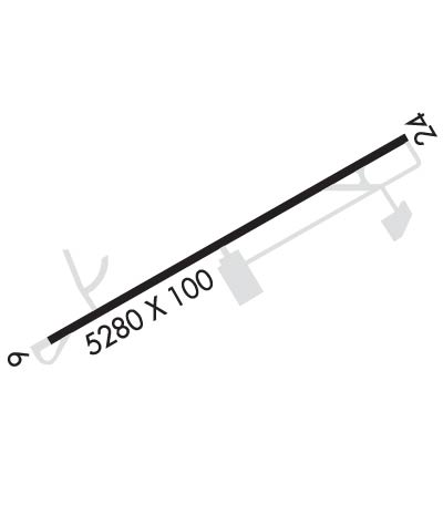
| Lat: N 3659.3 Long: W 08231.8 Elev: 2684 Var: +06 Longest Runway: 5280 | ||
| AWOS: 118.6 CTAF: 123.0 | ||
| ||||||||||||||||||||||||||||||||||||||||||||
| ||||||||||||||||||||||||||||||||||||||||||||
| ||||||||||||||||||||||||||||||||||||||||||||
| Rwy | Rwy | |||||||
| 5280x100 | 5280' | 5280x100 | 5280' | 110.70 - 242° | ||||
| Runway ID | Single Wheel | Double Wheel | Double Tandem Wheel | Dual Double Wheel |
| 06/24 | 42,000 | 55,000 | 100,000 | N/A |
| These numbers are Advisory and are not limits. The Airport Manager should have more accurate Weight Limits | ||||
 Airport Diagram might not be current. | |
| Facility Name: | LONESOME PINE |
| City Name: | WISE |
| County: | WISE |
| State abbrev: | VA |
| State Name: | VIRGINIA |
| Ownership: | PUBLICLY OWNED |
| Use: | OPEN TO THE PUBLIC |
| Owner's Name: | THE CUMBERLAND ARPT COMSN; DONNIE ROSE, CHAIRMAN. |
| Address: | 6225 AIRPORT ROAD |
| WISE, VA 24293 | |
| Owner's Phone: | 276-328-5300 |
| Manager's Name: | JARROD S. POWERS |
| Address: | 6225 AIRPORT RD. |
| WISE, VA 24293 | |
| Phone: | 276-328-5300; AFT HRS CTC 276-345-7289 OR 276-219-9807. |
| FAA Region: | EASTERN |
| FAA Field Office: | DCA |
| Date | Sunrise | Sunset |
|---|---|---|
| 09/24/21 Friday | 7:19 | 19:24 |
| 09/25/21 Saturday | 7:20 | 19:23 |
| 09/26/21 Sunday | 7:21 | 19:21 |
| 09/27/21 Monday | 7:22 | 19:20 |
| 09/28/21 Tuesday | 7:23 | 19:18 |
| 09/29/21 Wednesday | 7:24 | 19:17 |
| 09/30/21 Thursday | 7:24 | 19:15 |
| 10/01/21 Friday | 7:25 | 19:14 |
| 10/02/21 Saturday | 7:26 | 19:12 |
| 10/03/21 Sunday | 7:27 | 19:11 |
| 10/04/21 Monday | 7:28 | 19:09 |
| 10/05/21 Tuesday | 7:29 | 19:08 |
| 10/06/21 Wednesday | 7:30 | 19:06 |
| 10/07/21 Thursday | 7:30 | 19:05 |
| Airport Attendance Schedule | MON-SAT 0900-1800 |
| Airport Status | OPERATIONAL (This Status can change at any time - please check NOTAMS) |
| Airport Lighting Schedule | ACTVT ODALS RWY 24; REIL RWY 6 & 24; MIRL 6/24 - CTAF. |
| Airport Storage Available | Tie Downs, Hanger |
| Extra Services Available | Flight Instruction, Aircraft Rental, Annual Surveying |
| Wind Indicator | YES - (lighted) |
| Control Tower | NO |
| CTAF Frequency | 123.000 |
| Unicom Frequency | 123.000 |
| Rotating Beacon Color | CLEAR-GREEN (Light Land Airport) |
| Segmented Circle | YES |
| Landing Fee | NO |
| Airport Inspected | STATE - performed by STATE AERONAUTICAL PERSONNEL |
| Inspection Date | 10/06/2020 |
| Type of Fuel Available | Grade 100LL, JET A |
| Airframe Repair Service | None |
| Power Plant Repair Service | None |
| Latitude | N3659.3 |
| Longitude | W08231.8 (ESTIMATED) |
| Arpt Elevation | 2684ft (SURVEYED) |
| Magnetic Variation | 06W |
| 3 miles NE | of WISE |
| Traffic Pattern Altitude | |
| Sectional Chart | CINCINNATI |
| Operations (Reported) | Yearly | Avg. Daily |
|---|---|---|
| General Aviation Transient | 6146 | 17 |
| General Aviation Local | 3279 | 9 |
| Air Taxi | 0 | 0 |
| Commerical | 0 | 0 |
| Commuter | 0 | 0 |
| Military | 0 | 0 |
| Aircraft based on Field | |
|---|---|
| General Aviation Singles | 9 |
| General Aviation Multi | 2 |
| Jet Aircraft | 1 |
| General Aviation Helicopters | 0 |
| Military Aircraft | 0 |
| Gliders | 0 |
| Ultralights | 0 |
| FSS on field | NO |
| FSS tie-in | LEESBURG |
| FSS Phone | 1-800-WX-BRIEF |
| Who issues Notams | LNP |
| Notam D service at airport | YES |
| ARTCC Name | INDIANAPOLIS |
| Airport Certification | |
| Aircraft Rescue & Firefighting Index | None |
| Airport of Entry | No |
| Custom Landing Rights | No |
| Joint Civil/Military | No |
| Military Landing rights | YES |
| NATIONAL PLAN OF INTEGRATED AIRPORT SYSTEMS (NPIAS) |
| GRANT AGREEMENTS UNDER FAAP/ADAP/AIP |
| ASSURANCES PURSUANT TO TITLE VI, CIVIL RIGHTS ACT OF 1964 |
| RY 06/24 - THREE INCH GRADUAL DIP STARTING 2000 FT FROM THLD RY 24 CONTINUING FOR 300 FT. |
| WILDLIFE ON/INVOF AIRPORT. |
| UNATTENDED SUNDAY |
| FOR CD CTC INDIANAPOLIS ARTCC AT 317-247-2411. |
Airport Communications & Frequencies:
| |||||||||
| Runway: 06 | Runway: 24 | ||
| Mag heading: | 62° | Mag heading: | 242° |
| Rwy Slope: | .27% Up | Rwy Slope: | -.27% Down |
| Approach: | Approach: | ILS/DME | |
| Pattern: | Left Traffic | Pattern: | Left Traffic |
| Markings: | NONPRECISION INSTRUMENT | Markings: | NONPRECISION INSTRUMENT |
| Marking Condition: | FAIR; MARKINGS PARTIALLY OBSCURED BY ALGAE. | Marking Condition: | FAIR; MARKINGS PARTIALLY OBSCURED BY ALGAE. |
| Arresting Dev: | Arresting Dev: | ||
| Lat & Long: | N3659.0 W08232.3 | Lat. & Long.: | N3659.5 W08231.3 |
| Elev: | 2669.8 ft. MSL | Elev: | 2684.2 ft. MSL |
| TCH: | 34 ft. AGL | TCH: | 36 ft. AGL |
| Visual Glide Path: | 3.00 degrees | Visual Glide Path: | 3.00 degrees |
| Displaced Threshold: | No | Displaced Threshold: | No |
| Touchdown Zone: | YES | Touchdown Zone: | YES |
| Touchdown Elev.: | 2670.5 feet | Touchdown Elev.: | 2684.3 feet |
| Visual Glide Slope: | 2-Light PAPI on LEFT side of Runway | Visual Glide Slope: | 2-Light PAPI on RIGHT side of Runway |
| RVR Equipment: | RVR Equipment: | ||
| RVV Equipment: | NO | RVV Equipment: | NO |
| Approach Lights: | Approach Lights: | ODALS - omnidirectional approach lighting system; NSTD ODALS; 5 LGT CONFIGN. | |
| REIL: | YES | REIL: | YES |
| Centerline Lights: | NO | Centerline Lights: | NO |
| Touchdown lights: | NO | Touchdown lights: | NO |
| Runway Category: | Runway with a Non-precision Approach having visibility minimums greater than 3/4 mile | Runway Category: | Runway with a Non-precision Approach having visibility minimums greater than 3/4 mile |
| Declared Distances: | Declared Distances: | ||
| Obstructions: | TREES | Obstructions: | TREES |
| Marked: | NOT Marked/Lighted | Marked: | NOT Marked/Lighted |
| Clearance slope: | 11:1 | Clearance slope: | 14:1 |
| Obstruction height: | 65 feet AGL | Obstruction height: | 49 feet AGL |
| Dist. from runway: | 939 feet | Dist. from runway: | 934 feet |
| Centerline offset: | 240 right of centerline | Centerline offset: | 337 feet left of centerline |
| Comments: | Comments: |
Thanks for using FltPlan.com
all rights reserved © 1999-2021 by Flight Plan LLC
