
| KLAMATH FALLS KLAMATH FALLS OR |
| |
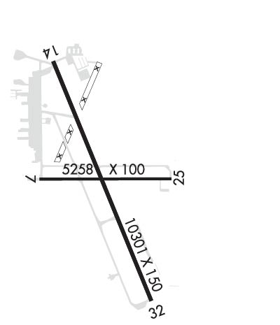
| Lat: N 4209.4 Long: W 12144.0 Elev: 4095 Var: -17 Longest Runway: 10302 | ||
| Dept. ATIS: 126.5 Arr. ATIS: 126.5 Ground: 121.9 Tower: 133.97 | ||
| ||||||||||||||||||||||||||||||||||||||||||||
| ||||||||||||||||||||||||||||||||||||||||||||
| ||||||||||||||||||||||||||||||||||||||||||||
| Rwy | Rwy | |||||||
| 5258x100 | 4952' | 5258x100 | 4746' | |||||
| 10302x150 | 10302' | 10302x150 | 10302' | 109.50 - 321° | ||||
| Runway ID | Single Wheel | Double Wheel | Double Tandem Wheel | Dual Double Wheel |
| 07/25 | 53,000 | 77,000 | N/A | N/A |
| 14/32 | 107,000 | 175,000 | 315,000 | N/A |
| These numbers are Advisory and are not limits. The Airport Manager should have more accurate Weight Limits | ||||
 Airport Diagram might not be current. | |
| Facility Name: | CRATER LAKE-KLAMATH RGNL |
| City Name: | KLAMATH FALLS |
| County: | KLAMATH |
| State abbrev: | OR |
| State Name: | OREGON |
| Ownership: | PUBLICLY OWNED |
| Use: | OPEN TO THE PUBLIC |
| Owner's Name: | CITY OF KLAMATH FALLS |
| Address: | CITY HALL PO BOX 237 |
| KLAMATH FALLS, OR 97601 | |
| Owner's Phone: | 541-883-5316 |
| Manager's Name: | JOHN BARSALOU |
| Address: | 6775 ARNOLD AVENUE |
| KLAMATH FALLS, OR 97603 | |
| Phone: | (541) 883-5373; ALT FONE- 541-539-8977. |
| FAA Region: | NORTHWEST MOUNTAIN |
| FAA Field Office: | SEA |

| Date | Sunrise | Sunset |
|---|---|---|
| 09/24/21 Friday | 6:56 | 19:01 |
| 09/25/21 Saturday | 6:57 | 18:59 |
| 09/26/21 Sunday | 6:58 | 18:57 |
| 09/27/21 Monday | 6:59 | 18:56 |
| 09/28/21 Tuesday | 7:01 | 18:54 |
| 09/29/21 Wednesday | 7:02 | 18:52 |
| 09/30/21 Thursday | 7:03 | 18:50 |
| 10/01/21 Friday | 7:04 | 18:49 |
| 10/02/21 Saturday | 7:05 | 18:47 |
| 10/03/21 Sunday | 7:06 | 18:45 |
| 10/04/21 Monday | 7:07 | 18:44 |
| 10/05/21 Tuesday | 7:08 | 18:42 |
| 10/06/21 Wednesday | 7:09 | 18:40 |
| 10/07/21 Thursday | 7:10 | 18:38 |
| Airport Attendance Schedule | DEC - MAR MON-FRI 0630-2230, SAT-SUN UNATNDD, APR - NOV MON-FRI 0730-1700 |
| Airport Status | OPERATIONAL (This Status can change at any time - please check NOTAMS) |
| Airport Lighting Schedule | WHEN ATCT CLSD ACTVT MALSF RWY 14, MALSR RWY 32, HIRL RWY 14/32, MIRL RWY 07/25 & TWY LGTS - CTAF. RWY AND TWY LGTS ALSO ACTVT ON 257.8. REIL RWY 25; PAPI RWY 25, PAPI RWY 14 & VASI RWY 32 OPR CONSLY. |
| Airport Storage Available | Tie Downs, Hanger |
| Extra Services Available | Air Freight, Crop Dusting, Cargo Handling, Charter, Flight Instruction |
| Wind Indicator | YES - (lighted) |
| Control Tower | YES |
| CTAF Frequency | 133.975 |
| Unicom Frequency | 122.950 |
| Rotating Beacon Color | CLEAR-GREEN (Light Land Airport) |
| Segmented Circle | YES |
| Landing Fee | YES |
| Airport Inspected | FEDERAL - performed by FAA AIRPORTS FIELD PERSONNEL |
| Inspection Date | 08/21/2019 |
| Type of Fuel Available | Grade 100LL, JET A (freeze point -40C) |
| Airframe Repair Service | MAJOR |
| Power Plant Repair Service | MAJOR |
| Latitude | N4209.4 |
| Longitude | W12144.0 (ESTIMATED) |
| Arpt Elevation | 4095ft (SURVEYED) |
| Magnetic Variation | 17E |
| 4 miles SE | of KLAMATH FALLS |
| Traffic Pattern Altitude | |
| Sectional Chart | KLAMATH FALLS |
| Operations (Reported) | Yearly | Avg. Daily |
|---|---|---|
| General Aviation Transient | 10217 | 28 |
| General Aviation Local | 11464 | 31 |
| Air Taxi | 3491 | 10 |
| Commerical | 0 | 0 |
| Commuter | 0 | 0 |
| Military | 17459 | 48 |
| Aircraft based on Field | |
|---|---|
| General Aviation Singles | 63 |
| General Aviation Multi | 10 |
| Jet Aircraft | 11 |
| General Aviation Helicopters | 2 |
| Military Aircraft | 32 |
| Gliders | 0 |
| Ultralights | 0 |
| FSS on field | NO |
| FSS tie-in | MC MINNVILLE |
| FSS Phone | 1-800-WX-BRIEF |
| Who issues Notams | LMT |
| Notam D service at airport | YES |
| ARTCC Name | SEATTLE |
| Airport Certification | |
| Aircraft Rescue & Firefighting Index | AIRPORT HAS A CERTIFICATE UNDER CFR PART 139 |
| Airport of Entry | No |
| Custom Landing Rights | No |
| Joint Civil/Military | No |
| Military Landing rights | YES |
| NATIONAL PLAN OF INTEGRATED AIRPORT SYSTEMS (NPIAS) |
| GRANT AGREEMENTS UNDER FAAP/ADAP/AIP |
| SURPLUS PROPERTY AGREEMENT UNDER PUBLIC LAW 289 |
| CONVEYANCE UNDER SCETION 16, FEDERAL AIRPORT ACT OF 1946 OR SECTION 23, AIRPORT AND AIRWAY DEVELOPMENT ACT OF 1970 |
| ASSURANCES PURSUANT TO TITLE VI, CIVIL RIGHTS ACT OF 1964 |
| FLOCKS OF LARGE MIGRATORY WATERFOWL IN VICINITY NOV-MAY. |
| MILITARY ANG: PPR FR ANG BASE OPS RQR FOR TRAN MIL APCHES BTN 0400-1500Z++. OFFL BUS ONLY, PPR DSN 830-6686. BASE OPS OPR 1330-2359Z++ MON-FRI EXC HOL. |
| MILITARY SVC-FUEL: 1500-0300Z++, C541-882-4681, $150 FEE, 20 MIN PN. |
| MILITARY BASH PHASE II - FEB THRU MAY & SEPT THRU NOV. BASH PHASE I - ALL MONTHS NOT DESIGNATED AS PHASE II. |
| TWY D BTN TWY E & TWY F RSTRD MIL OPS ONLY. |
| TWY A WEST OF TWY D RSTRD MIL OPS ONLY. |
| BAK-12B/TYPE-H RWY 14/32 |
| FOR FBO HOURS CONTACT 541-882-4681. |
| TWY GOLF S RUN UP PAD CLSD EXC TO MIL OPS. |
| COND NOT MNTD DLY 2230 TO 0630. CONDS NOT MNTD SAT & SUN. |
| FOR CD IF UNA TO CTC ON FSS FREQ, CTC SEATTLE ARTCC AT 253-351-3694. |
| MILITARY ANG: ALL HVY ACFT PLEASE TAXI TO NORTH OR SOUTH EOR UPON LDG. ONCE IN EOR PLEASE SHUTDOWN ALL OUTBOARD ENGINES BEFORE TAXI TO MILITARY RAMP TO ELIMINATE ANY FOD HAZ. |
| CSTMS/AG/IMG - SVCS UNAVBL. KPDX IS CLOSEST ARPT WITH CUSTOMS AGENT C503-326-3249, C503-326-3230. |
| FUEL: A++(MIL) |
Airport Communications & Frequencies:
| |||||||||||||||||||||||||||||||
| Runway: 07 | Runway: 25 | ||
| Mag heading: | 73° | Mag heading: | 253° |
| Rwy Slope: | -.05% Down | Rwy Slope: | .05% Up |
| Approach: | Approach: | ||
| Pattern: | Left Traffic | Pattern: | Left Traffic |
| Markings: | NONPRECISION INSTRUMENT | Markings: | NONPRECISION INSTRUMENT |
| Marking Condition: | GOOD | Marking Condition: | GOOD |
| Arresting Dev: | Arresting Dev: | ||
| Lat & Long: | N4209.4 W12144.6 | Lat. & Long.: | N4209.4 W12143.4 |
| Elev: | 4091.9 ft. MSL | Elev: | 4089.1 ft. MSL |
| TCH: | TCH: | 34 ft. AGL | |
| Visual Glide Path: | Visual Glide Path: | 3.00 degrees | |
| Displaced Threshold: | 306 feet | Displaced Threshold: | 512 feet |
| Touchdown Zone: | YES | Touchdown Zone: | YES |
| Touchdown Elev.: | 4091.4 feet | Touchdown Elev.: | 4090.4 feet |
| Visual Glide Slope: | Visual Glide Slope: | 4-Light PAPI on LEFT side of Runway | |
| RVR Equipment: | RVR Equipment: | ||
| RVV Equipment: | NO | RVV Equipment: | NO |
| Approach Lights: | Approach Lights: | ||
| REIL: | NO | REIL: | YES |
| Centerline Lights: | NO | Centerline Lights: | NO |
| Touchdown lights: | NO | Touchdown lights: | NO |
| Runway Category: | Runway with a Visual Approach | Runway Category: | Runway with a Visual Approach |
| Declared Distances: | TORA:5258' TODA:5258' ASDA:5258' LDA:4952' | Declared Distances: | TORA:5258' TODA:5258' ASDA:5258' LDA:4746' |
| Obstructions: | RR | Obstructions: | FENCE |
| Marked: | NOT Marked/Lighted | Marked: | NOT Marked/Lighted |
| Clearance slope: | 16:1; APCH SLOPE 29:1 TO DSPLCD THR. | Clearance slope: | APCH SLOPE 34:1 TO DSPLCD THLD. |
| Obstruction height: | 25 feet AGL | Obstruction height: | 8 feet AGL |
| Dist. from runway: | 625 feet | Dist. from runway: | 86 feet |
| Centerline offset: | 125 right of centerline | Centerline offset: | 125 feet right of centerline |
| Comments: | Comments: |
| Runway: 14 | Runway: 32 | ||
| Mag heading: | 141° | Mag heading: | 321° |
| Rwy Slope: | .04% Up | Rwy Slope: | -.04% Down |
| Approach: | Approach: | ILS | |
| Pattern: | Left Traffic | Pattern: | Left Traffic |
| Markings: | PRECISION INSTRUMENT | Markings: | PRECISION INSTRUMENT |
| Marking Condition: | GOOD | Marking Condition: | FAIR |
| Arresting Dev: | BAK-12; TYPE H BAK-12B(B)(1500') | Arresting Dev: | BAK-12; TYPE H BAK-12B(B)(1500') |
| Lat & Long: | N4210.2 W12144.4 | Lat. & Long.: | N4208.6 W12143.6 |
| Elev: | 4091.0 ft. MSL | Elev: | 4095.4 ft. MSL |
| TCH: | 50 ft. AGL | TCH: | 55 ft. AGL |
| Visual Glide Path: | 3.00 degrees | Visual Glide Path: | 3.00 degrees |
| Displaced Threshold: | No | Displaced Threshold: | No |
| Touchdown Zone: | YES | Touchdown Zone: | YES |
| Touchdown Elev.: | 4091.1 feet | Touchdown Elev.: | 4095.4 feet |
| Visual Glide Slope: | 4-Light PAPI on LEFT side of Runway; RWY 14 PAPI BYD 3.5 NM UNUSBL. | Visual Glide Slope: | 4-BOX VASI ON LEFT SIDE OF RUNWAY |
| RVR Equipment: | ROLLOUT | RVR Equipment: | TOUCHDOWN |
| RVV Equipment: | NO | RVV Equipment: | NO |
| Approach Lights: | MALSF - 1,400 foot medium intensity approach lighting system with sequenced flashers | Approach Lights: | MALSR - 1,400 foot medium intensity approach lighting system with runway alignment indicator lights |
| REIL: | NO | REIL: | NO |
| Centerline Lights: | NO | Centerline Lights: | NO |
| Touchdown lights: | NO | Touchdown lights: | NO |
| Runway Category: | Runway with a Non-precision Approach having visibility minimums greater than 3/4 mile | Runway Category: | Precision Instrument Runway |
| Declared Distances: | TORA:10302' TODA:10302' ASDA:10302' LDA:10302' | Declared Distances: | TORA:10302' TODA:10302' ASDA:10302' LDA:10302' |
Thanks for using FltPlan.com
all rights reserved © 1999-2021 by Flight Plan LLC