
| LITTLE RIVER LITTLE RIVER CA |
| |
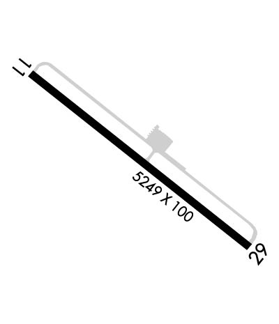
| Lat: N 3915.7 Long: W 12345.2 Elev: 574 Var: -15 Longest Runway: 5249 | ||
| CTAF: 122.7 | ||
| ||||||
|
| Rwy | Rwy | |||||||
| 5249x100 | 5049' | 5249x100 | 5249' | |||||
| Runway ID | Single Wheel | Double Wheel | Double Tandem Wheel | Dual Double Wheel |
| 11/29 | 60,000 | 200,000 | 400,000 | N/A |
| These numbers are Advisory and are not limits. The Airport Manager should have more accurate Weight Limits | ||||
 Airport Diagram might not be current. | |
| Facility Name: | LITTLE RIVER |
| City Name: | LITTLE RIVER |
| County: | MENDOCINO |
| State abbrev: | CA |
| State Name: | CALIFORNIA |
| Ownership: | PUBLICLY OWNED |
| Use: | OPEN TO THE PUBLIC |
| Owner's Name: | MENDOCINO COUNTY |
| Address: | 340 LAKE MENDOCINO DRIVE |
| UKIAH, CA 95482-9432 | |
| Owner's Phone: | 707-463-4363 |
| Manager's Name: | HOWARD DASHIELL; DEPUTY DIRECTOR |
| Address: | 340 LAKE MENDOCINO DRIVE |
| UKIAH, CA 95482-9432 | |
| Phone: | (707) 463-4363 |
| FAA Region: | WESTERN-PACIFIC |
| FAA Field Office: | SFO |

| Date | Sunrise | Sunset |
|---|---|---|
| 09/24/21 Friday | 7:04 | 19:09 |
| 09/25/21 Saturday | 7:05 | 19:07 |
| 09/26/21 Sunday | 7:06 | 19:06 |
| 09/27/21 Monday | 7:07 | 19:04 |
| 09/28/21 Tuesday | 7:08 | 19:03 |
| 09/29/21 Wednesday | 7:09 | 19:01 |
| 09/30/21 Thursday | 7:10 | 18:59 |
| 10/01/21 Friday | 7:11 | 18:58 |
| 10/02/21 Saturday | 7:12 | 18:56 |
| 10/03/21 Sunday | 7:13 | 18:55 |
| 10/04/21 Monday | 7:14 | 18:53 |
| 10/05/21 Tuesday | 7:15 | 18:51 |
| 10/06/21 Wednesday | 7:16 | 18:50 |
| 10/07/21 Thursday | 7:17 | 18:48 |
| Airport Attendance Schedule | THU-MON 0800-1700 |
| Airport Status | OPERATIONAL (This Status can change at any time - please check NOTAMS) |
| Airport Lighting Schedule | ACTVT PAPI RWY 29; MIRL RWY 11/29 - CTAF |
| Airport Storage Available | Tie Downs |
| Extra Services Available | Charter, Flight Instruction |
| Wind Indicator | YES - (lighted) |
| Control Tower | NO |
| CTAF Frequency | 122.700 |
| Unicom Frequency | 122.700; AUTOMATED UNICOM. |
| Rotating Beacon Color | CLEAR-GREEN (Light Land Airport) |
| Segmented Circle | YES |
| Landing Fee | NO |
| Airport Inspected | STATE - performed by STATE AERONAUTICAL PERSONNEL |
| Inspection Date | 02/18/2020 |
| Type of Fuel Available | Grade 100LL |
| Airframe Repair Service | NONE |
| Power Plant Repair Service | NONE |
| Latitude | N3915.7 |
| Longitude | W12345.2 (ESTIMATED) |
| Arpt Elevation | 573ft (SURVEYED) |
| Magnetic Variation | 15E |
| 3 miles SE | of LITTLE RIVER |
| Traffic Pattern Altitude | |
| Sectional Chart | SAN FRANCISCO |
| Operations (Reported) | Yearly | Avg. Daily |
|---|---|---|
| General Aviation Transient | 2050 | 6 |
| General Aviation Local | 850 | 2 |
| Air Taxi | 100 | 0 |
| Commerical | 0 | 0 |
| Commuter | 0 | 0 |
| Military | 0 | 0 |
| Aircraft based on Field | |
|---|---|
| General Aviation Singles | 13 |
| General Aviation Multi | 0 |
| Jet Aircraft | 0 |
| General Aviation Helicopters | 0 |
| Military Aircraft | 0 |
| Gliders | 0 |
| Ultralights | 0 |
| FSS on field | NO |
| FSS tie-in | OAKLAND |
| FSS Phone | 1-800-WX-BRIEF |
| Who issues Notams | OAK |
| Notam D service at airport | YES |
| ARTCC Name | OAKLAND |
| Airport Certification | |
| Aircraft Rescue & Firefighting Index | None |
| Airport of Entry | No |
| Custom Landing Rights | No |
| Joint Civil/Military | No |
| Military Landing rights | YES |
| NATIONAL PLAN OF INTEGRATED AIRPORT SYSTEMS (NPIAS) |
| SURPLUS PROPERTY AGREEMENT UNDER REGULATION 16-WAA |
| GRANT AGREEMENT HAS EXPIRED; HOWEVER, AGREEMENT REMAINS IN EFFECT FOR THIS FACILITY AS LONG AS IT IS PUBLIC USE. |
| FOR ARPT ATTENDANT CTC (707) 937-5129. |
| FOR CD CTC OAKLAND ARTCC AT 510-745-3380. |
Airport Communications & Frequencies:
| |||||||||
| Runway: 11 | Runway: 29 | ||
| Mag heading: | 113° | Mag heading: | 293° |
| Rwy Slope: | .50% Up | Rwy Slope: | -.50% Down |
| Approach: | Approach: | ||
| Pattern: | Left Traffic | Pattern: | Left Traffic |
| Markings: | BASIC | Markings: | BASIC |
| Marking Condition: | GOOD | Marking Condition: | GOOD |
| Arresting Dev: | Arresting Dev: | ||
| Lat & Long: | N3916.0 W12345.7 | Lat. & Long.: | N3915.5 W12344.8 |
| Elev: | 547.6 ft. MSL | Elev: | 573.8 ft. MSL |
| TCH: | TCH: | 42 ft. AGL | |
| Visual Glide Path: | Visual Glide Path: | 3.50 degrees | |
| Displaced Threshold: | 200 feet | Displaced Threshold: | No |
| Touchdown Zone: | YES | Touchdown Zone: | YES |
| Touchdown Elev.: | 562.6 feet | Touchdown Elev.: | 573.8 feet |
| Visual Glide Slope: | Visual Glide Slope: | 4-Light PAPI on LEFT side of Runway | |
| RVR Equipment: | RVR Equipment: | ||
| RVV Equipment: | NO | RVV Equipment: | NO |
| Approach Lights: | Approach Lights: | ||
| REIL: | NO | REIL: | NO |
| Centerline Lights: | NO | Centerline Lights: | NO |
| Touchdown lights: | NO | Touchdown lights: | NO |
| Runway Category: | Runway with a Visual Approach | Runway Category: | Runway with a Non-precision Approach having visibility minimums greater than 3/4 mile |
| Declared Distances: | Declared Distances: | ||
| Obstructions: | BRUSH | Obstructions: | TREES |
| Marked: | NOT Marked/Lighted | Marked: | NOT Marked/Lighted |
| Clearance slope: | RWY 11 APCH RATIO 31:1 TO DSPLCD THR OVER +35' TREES @ 1200', 312' RIGHT FM EOR. | Clearance slope: | 28:1 |
| Obstruction height: | 6 feet AGL | Obstruction height: | 45 feet AGL |
| Dist. from runway: | 200 feet | Dist. from runway: | 1500 feet |
| Centerline offset: | Centerline offset: | ||
| Comments: | Comments: |
Thanks for using FltPlan.com
all rights reserved © 1999-2021 by Flight Plan LLC