
| LEVELLAND MUNI LEVELLAND TX |
| |
| Lat: N 3333.2 Long: W 10222.4 Elev: 3514 Var: -09 Longest Runway: 6110 | ||
| CTAF: 122.8 | ||
| ||||||
| ||||||
|
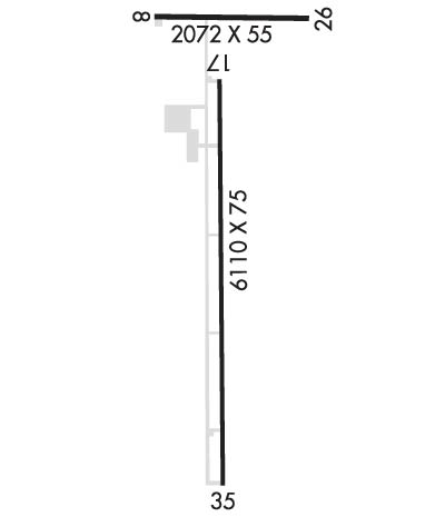
| Rwy | Rwy | |||||||
| 2072x55 | 2072' | 2072x55 | 2072' | |||||
| 6110x75 | 6110' | 6110x75 | 6110' | |||||
| Runway ID | Single Wheel | Double Wheel | Double Tandem Wheel | Dual Double Wheel |
| 08/26 | N/A | N/A | N/A | N/A |
| 17/35 | 30,000 | N/A | N/A | N/A |
| These numbers are Advisory and are not limits. The Airport Manager should have more accurate Weight Limits | ||||
 Airport Diagram might not be current. | |
| Facility Name: | LEVELLAND MUNI |
| City Name: | LEVELLAND |
| County: | HOCKLEY |
| State abbrev: | TX |
| State Name: | TEXAS |
| Ownership: | PUBLICLY OWNED |
| Use: | OPEN TO THE PUBLIC |
| Owner's Name: | LEVELLAND CITY & HOCKLEY CO |
| Address: | PO BOX 1010 |
| LEVELLAND, TX 79336 | |
| Owner's Phone: | 806-470-8768 |
| Manager's Name: | RICHARD HARVEY |
| Address: | P.O. BOX 1624 |
| LEVELLAND, TX 79336 | |
| Phone: | 806-470-8768 |
| FAA Region: | SOUTHWEST |
| FAA Field Office: | TEX |
| Date | Sunrise | Sunset |
|---|---|---|
| 06/07/26 Sunday | 6:39 | 20:58 |
| 06/08/26 Monday | 6:39 | 20:58 |
| 06/09/26 Tuesday | 6:39 | 20:59 |
| 06/10/26 Wednesday | 6:39 | 20:59 |
| 06/11/26 Thursday | 6:39 | 20:59 |
| 06/12/26 Friday | 6:39 | 21:00 |
| 06/13/26 Saturday | 6:39 | 21:00 |
| 06/14/26 Sunday | 6:39 | 21:01 |
| 06/15/26 Monday | 6:39 | 21:01 |
| 06/16/26 Tuesday | 6:39 | 21:01 |
| 06/17/26 Wednesday | 6:39 | 21:02 |
| 06/18/26 Thursday | 6:39 | 21:02 |
| 06/19/26 Friday | 6:39 | 21:02 |
| 06/20/26 Saturday | 6:40 | 21:02 |
| Airport Attendance Schedule | MON-FRI 0800-1600 |
| Airport Status | OPERATIONAL (This Status can change at any time - please check NOTAMS) |
| Airport Lighting Schedule | MIRL RWY 17/35 PRESET LOW INTST; TO INCR INTST ACTVT - CTAF. |
| Airport Storage Available | Tie Downs |
| Extra Services Available | Crop Dusting |
| Wind Indicator | YES - (lighted) |
| Control Tower | NO |
| CTAF Frequency | 122.800 |
| Unicom Frequency | 122.800 |
| Rotating Beacon Color | WG |
| Segmented Circle | YES |
| Landing Fee | NO |
| Airport Inspected | STATE - performed by PRIVATE CONTRACT PERSONNEL |
| Inspection Date | 04/19/2024 |
| Type of Fuel Available | Grade 100LL, JET A (freeze point -40C); -10FUEL SELF-SVC. |
| Airframe Repair Service | MAJOR |
| Power Plant Repair Service | MAJOR |
| Latitude | N3333.2 |
| Longitude | W10222.4 (ESTIMATED) |
| Arpt Elevation | 3514ft (SURVEYED) |
| Magnetic Variation | 09E |
| 2 miles S | of LEVELLAND |
| Traffic Pattern Altitude | |
| Sectional Chart | ALBUQUERQUE |
| Operations (Reported) | Yearly | Avg. Daily |
|---|---|---|
| General Aviation Transient | 0 | 0 |
| General Aviation Local | 0 | 0 |
| Air Taxi | 0 | 0 |
| Commerical | 0 | 0 |
| Commuter | 0 | 0 |
| Military | 0 | 0 |
| Aircraft based on Field | |
|---|---|
| General Aviation Singles | 0 |
| General Aviation Multi | 0 |
| Jet Aircraft | 0 |
| General Aviation Helicopters | 0 |
| Military Aircraft | 0 |
| Gliders | 0 |
| Ultralights | 0 |
| FSS on field | NO |
| FSS tie-in | FORT WORTH |
| FSS Phone | 1-800-WX-BRIEF |
| Who issues Notams | FTW |
| Notam D service at airport | YES |
| ARTCC Name | FORT WORTH |
| Airport Certification | |
| Aircraft Rescue & Firefighting Index | None |
| Airport of Entry | No |
| Custom Landing Rights | No |
| Joint Civil/Military | No |
| Military Landing rights | YES |
| NATIONAL PLAN OF INTEGRATED AIRPORT SYSTEMS (NPIAS) |
| GRANT AGREEMENTS UNDER FAAP/ADAP/AIP |
| ASSURANCES PURSUANT TO TITLE VI, CIVIL RIGHTS ACT OF 1964 |
| THIS AIRPORT HAS BEEN SURVEYED BY THE NATIONAL GEODETIC SURVEY. |
| FOR CD CTC FORT WORTH ARTCC AT 817-858-7584. |
| ACFT NOT VISIBLE FROM OPPOSITE RWY END. |
Airport Communications & Frequencies:
| ||||||||||||||||||||||
| Runway: 08 | Runway: 26 | ||
| Mag heading: | 83° | Mag heading: | 263° |
| Rwy Slope: | -.25% Down | Rwy Slope: | .25% Up |
| Approach: | Approach: | ||
| Pattern: | Right Traffic | Pattern: | Left Traffic |
| Markings: | Markings: | ||
| Marking Condition: | Marking Condition: | ||
| Arresting Dev: | Arresting Dev: | ||
| Lat & Long: | N3333.6 W10222.5 | Lat. & Long.: | N3333.6 W10222.1 |
| Elev: | 3509.5 ft. MSL | Elev: | 3504.3 ft. MSL |
| TCH: | TCH: | ||
| Visual Glide Path: | Visual Glide Path: | ||
| Displaced Threshold: | No | Displaced Threshold: | No |
| Touchdown Zone: | YES | Touchdown Zone: | YES |
| Touchdown Elev.: | 3509.5 feet | Touchdown Elev.: | 3509.5 feet |
| Visual Glide Slope: | Visual Glide Slope: | ||
| RVR Equipment: | RVR Equipment: | ||
| RVV Equipment: | NO | RVV Equipment: | NO |
| Approach Lights: | Approach Lights: | ||
| REIL: | NO | REIL: | NO |
| Centerline Lights: | NO | Centerline Lights: | NO |
| Touchdown lights: | NO | Touchdown lights: | NO |
| Runway Category: | Runway with a Visual Approach | Runway Category: | Runway with a Visual Approach |
| Declared Distances: | Declared Distances: | ||
| Obstructions: | ROAD | Obstructions: | ROAD |
| Marked: | NOT Marked/Lighted | Marked: | NOT Marked/Lighted |
| Clearance slope: | 26:1; PRIVATE RD. | Clearance slope: | |
| Obstruction height: | 15 feet AGL | Obstruction height: | 10 feet AGL |
| Dist. from runway: | 604 feet | Dist. from runway: | 202 feet |
| Centerline offset: | 165 right of centerline | Centerline offset: | 127 feet right of centerline |
| Comments: | Comments: | 4 FT FENCE, 185 FT DSTC, 125 FT L/R. |
| Runway: 17 | Runway: 35 | ||
| Mag heading: | 173° | Mag heading: | 353° |
| Rwy Slope: | .08% Up | Rwy Slope: | -.08% Down |
| Approach: | Approach: | ||
| Pattern: | Left Traffic | Pattern: | Right Traffic |
| Markings: | NONPRECISION INSTRUMENT | Markings: | NONPRECISION INSTRUMENT |
| Marking Condition: | GOOD | Marking Condition: | GOOD |
| Arresting Dev: | Arresting Dev: | ||
| Lat & Long: | N3333.5 W10222.3 | Lat. & Long.: | N3332.5 W10222.4 |
| Elev: | 3504.7 ft. MSL | Elev: | 3509.7 ft. MSL |
| TCH: | 47 ft. AGL | TCH: | 39 ft. AGL |
| Visual Glide Path: | 3.00 degrees | Visual Glide Path: | 3.00 degrees |
| Displaced Threshold: | No | Displaced Threshold: | No |
| Touchdown Zone: | YES | Touchdown Zone: | YES |
| Touchdown Elev.: | 3508.3 feet | Touchdown Elev.: | 3514.1 feet |
| Visual Glide Slope: | 4-Light PAPI on LEFT side of Runway | Visual Glide Slope: | 4-Light PAPI on LEFT side of Runway |
| RVR Equipment: | RVR Equipment: | ||
| RVV Equipment: | NO | RVV Equipment: | NO |
| Approach Lights: | Approach Lights: | ||
| REIL: | NO | REIL: | YES |
| Centerline Lights: | NO | Centerline Lights: | NO |
| Touchdown lights: | NO | Touchdown lights: | NO |
| Runway Category: | Runway with a Non-precision Approach having visibility minimums greater than 3/4 mile | Runway Category: | Runway with a Non-precision Approach having visibility minimums greater than 3/4 mile |
| Declared Distances: | Declared Distances: | ||
| Obstructions: | TREE | Obstructions: | |
| Marked: | NOT Marked/Lighted | Marked: | |
| Clearance slope: | 23:1 | Clearance slope: | 50:1 |
| Obstruction height: | 48 feet AGL | Obstruction height: | |
| Dist. from runway: | 1345 feet | Dist. from runway: | |
| Centerline offset: | 285 left of centerline | Centerline offset: | |
| Comments: | Comments: |
Thanks for using FltPlan.com
all rights reserved © 1999-2026 by Flight Plan LLC
