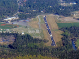
| LAKE PLACID LAKE PLACID NY |
| |
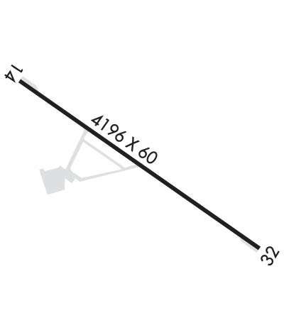
| Lat: N 4415.9 Long: W 07357.7 Elev: 1747 Var: +15 Longest Runway: 4196 | ||
| CTAF: 122.8 | ||
| |||||
|
| Rwy | Rwy | |||||||
| 4196x60 | 4196' | 4196x60 | 3056' | |||||
| Runway ID | Single Wheel | Double Wheel | Double Tandem Wheel | Dual Double Wheel |
| 14/32 | 8,000 | N/A | N/A | N/A |
| These numbers are Advisory and are not limits. The Airport Manager should have more accurate Weight Limits | ||||
 Airport Diagram might not be current. | |
| Facility Name: | LAKE PLACID |
| City Name: | LAKE PLACID |
| County: | ESSEX |
| State abbrev: | NY |
| State Name: | NEW YORK |
| Ownership: | PUBLICLY OWNED |
| Use: | OPEN TO THE PUBLIC |
| Owner's Name: | NORTH ELBA PARK DISTRICT; TOWN OF NORTH ELBA |
| Address: | 2693 MAIN ST |
| LAKE PLACID, NY 12946 | |
| Owner's Phone: | 518-302-5106 |
| Manager's Name: | SHANNON PORTER |
| Address: | 2693 MAIN ST |
| LAKE PLACID, NY 12946 | |
| Phone: | 518-302-5106 |
| FAA Region: | EASTERN |
| FAA Field Office: | NYC |
| Date | Sunrise | Sunset |
|---|---|---|
| 06/08/26 Monday | 5:12 | 20:38 |
| 06/09/26 Tuesday | 5:12 | 20:38 |
| 06/10/26 Wednesday | 5:12 | 20:39 |
| 06/11/26 Thursday | 5:12 | 20:39 |
| 06/12/26 Friday | 5:11 | 20:40 |
| 06/13/26 Saturday | 5:11 | 20:40 |
| 06/14/26 Sunday | 5:11 | 20:41 |
| 06/15/26 Monday | 5:11 | 20:41 |
| 06/16/26 Tuesday | 5:11 | 20:42 |
| 06/17/26 Wednesday | 5:11 | 20:42 |
| 06/18/26 Thursday | 5:11 | 20:42 |
| 06/19/26 Friday | 5:12 | 20:43 |
| 06/20/26 Saturday | 5:12 | 20:43 |
| 06/21/26 Sunday | 5:12 | 20:43 |
| Airport Attendance Schedule | 7 Days A Week 0900-1700 |
| Airport Status | OPERATIONAL (This Status can change at any time - please check NOTAMS) |
| Airport Lighting Schedule | ACTVT PAPI RWY 14; MIRL RWY 14/32; TWY LGTS - CTAF. |
| Airport Storage Available | Tie Downs, Hanger |
| Extra Services Available | Air Freight, Charter, Flight Instruction, Aircraft Rental, Annual Surveying |
| Wind Indicator | YES - (lighted) |
| Control Tower | NO |
| CTAF Frequency | 122.800 |
| Unicom Frequency | 122.800 |
| Rotating Beacon Color | |
| Segmented Circle | YES; SEGMENTED CIRCLE HAS NO TFC PATTERN INDICATOR. |
| Landing Fee | NO |
| Airport Inspected | STATE - performed by STATE AERONAUTICAL PERSONNEL |
| Inspection Date | 07/21/2025 |
| Type of Fuel Available | Grade 100LL, JET A (freeze point -40C) |
| Airframe Repair Service | MAJOR |
| Power Plant Repair Service | MAJOR |
| Latitude | N4415.9 |
| Longitude | W07357.7 (ESTIMATED) |
| Arpt Elevation | 1747ft (SURVEYED) |
| Magnetic Variation | 15W |
| 1 miles SE | of LAKE PLACID |
| Traffic Pattern Altitude | |
| Sectional Chart | MONTREAL |
| Operations (Reported) | Yearly | Avg. Daily |
|---|---|---|
| General Aviation Transient | 0 | 0 |
| General Aviation Local | 0 | 0 |
| Air Taxi | 0 | 0 |
| Commerical | 0 | 0 |
| Commuter | 0 | 0 |
| Military | 0 | 0 |
| Aircraft based on Field | |
|---|---|
| General Aviation Singles | 0 |
| General Aviation Multi | 0 |
| Jet Aircraft | 0 |
| General Aviation Helicopters | 0 |
| Military Aircraft | 0 |
| Gliders | 0 |
| Ultralights | 0 |
| FSS on field | NO |
| FSS tie-in | BURLINGTON |
| FSS Phone | 1-800-WX-BRIEF |
| Who issues Notams | BTV |
| Notam D service at airport | YES |
| ARTCC Name | BOSTON |
| Airport Certification | |
| Aircraft Rescue & Firefighting Index | None |
| Airport of Entry | No |
| Custom Landing Rights | No |
| Joint Civil/Military | No |
| Military Landing rights | YES |
| NATIONAL PLAN OF INTEGRATED AIRPORT SYSTEMS (NPIAS) |
| GRANT AGREEMENTS UNDER FAAP/ADAP/AIP |
| ASSURANCES PURSUANT TO TITLE VI, CIVIL RIGHTS ACT OF 1964 |
| MOUNTAINS ON BOTH APPROACHES 1-5 MILES FROM RWY ENDS. |
| EXTENSIVE GLIDER ACTIVITY SPRING AND FALL. |
| COLD TEMPERATURE AIRPORT. ALTITUDE CORRECTION REQUIRED AT OR BELOW -31C. |
| FOR CD CTC BOSTON ARTCC AT 603-879-6859. |
Airport Communications & Frequencies:
| |||||||||
| Runway: 14 | Runway: 32 | ||
| Mag heading: | 141° | Mag heading: | 321° |
| Rwy Slope: | .06% Up | Rwy Slope: | -.06% Down |
| Approach: | Approach: | ||
| Pattern: | Left Traffic | Pattern: | Left Traffic |
| Markings: | NONPRECISION INSTRUMENT | Markings: | NONPRECISION INSTRUMENT |
| Marking Condition: | GOOD | Marking Condition: | GOOD |
| Arresting Dev: | Arresting Dev: | ||
| Lat & Long: | N4416.1 W07358.1 | Lat. & Long.: | N4415.7 W07357.3 |
| Elev: | 1743.3 ft. MSL | Elev: | 1745.8 ft. MSL |
| TCH: | 51 ft. AGL | TCH: | |
| Visual Glide Path: | 3.50 degrees | Visual Glide Path: | |
| Displaced Threshold: | No | Displaced Threshold: | 1140 feet |
| Touchdown Zone: | YES | Touchdown Zone: | YES |
| Touchdown Elev.: | 1746.1 feet | Touchdown Elev.: | 1746.1 feet |
| Visual Glide Slope: | 2-Light PAPI on LEFT side of Runway; PAPI UNUSBL BYD 3 NM | Visual Glide Slope: | |
| RVR Equipment: | RVR Equipment: | ||
| RVV Equipment: | NO | RVV Equipment: | NO |
| Approach Lights: | Approach Lights: | ||
| REIL: | NO | REIL: | NO |
| Centerline Lights: | NO | Centerline Lights: | NO |
| Touchdown lights: | NO | Touchdown lights: | NO |
| Runway Category: | Runway with a Non-precision Approach | Runway Category: | Runway with a Visual Approach |
| Declared Distances: | Declared Distances: | ||
| Obstructions: | Obstructions: | TREES | |
| Marked: | Marked: | NOT Marked/Lighted | |
| Clearance slope: | 20:1 | Clearance slope: | 5:1; RWY 32 APCH RATIO 29:1 TO DTHR. |
| Obstruction height: | Obstruction height: | 57 feet AGL | |
| Dist. from runway: | Dist. from runway: | 532 feet | |
| Centerline offset: | Centerline offset: | 225 feet right of centerline | |
| Comments: | Comments: |
Thanks for using FltPlan.com
all rights reserved © 1999-2026 by Flight Plan LLC