
| ADAMS FIELD LITTLE ROCK AR |
| |
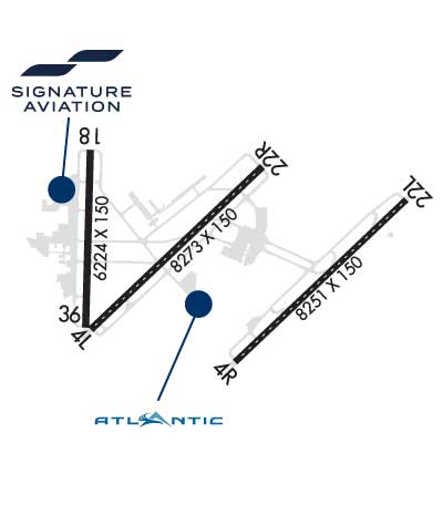
| Lat: N 3443.8 Long: W 09213.5 Elev: 266 Var: -00 Longest Runway: 8273 | ||
| Clr Del: 118.95 Dept. ATIS: 125.65 Arr. ATIS: 125.65 Ground: 121.9 Tower: 118.7 | ||
| |||||||||||||||||||||||||||||||||||||||||||||||||||||||||||||||||||||
| |||||||||||||||||||||||||||||||||||||||||||||||||||||||||||||||||||||
| |||||||||||||||||||||||||||||||||||||||||||||||||||||||||||||||||||||
| |||||||||||||||||||||||||||||||||||||||||||||||||||||||||||||||||||||
| |||||||||||||||||||||||||||||||||||||||||||||||||||||||||||||||||||||
| |||||||||||||||||||||||||||||||||||||||||||||||||||||||||||||||||||||
| Rwy | Rwy | |||||||
| 8273x150 | 7976' | 110.30 - 046° | 8273x150 | 8273' | 110.30 - 226° | |||
| 8251x150 | 7201' | 111.30 - 046° | 8251x150 | 8251' | 110.70 - 228° | |||
| 6224x150 | 6224' | 6224x150 | 6124' | |||||
| Runway ID | Single Wheel | Double Wheel | Double Tandem Wheel | Dual Double Wheel |
| 04L/22R | 75,000 | 200,000 | 350,000 | N/A |
| 04R/22L | 75,000 | 200,000 | 350,000 | N/A |
| 18/36 | 75,000 | 100,000 | 135,000 | N/A |
| These numbers are Advisory and are not limits. The Airport Manager should have more accurate Weight Limits | ||||
 Airport Diagram might not be current. | |
| Facility Name: | BILL AND HILLARY CLINTON NTL/ADAMS FLD |
| City Name: | LITTLE ROCK |
| County: | PULASKI |
| State abbrev: | AR |
| State Name: | ARKANSAS |
| Ownership: | PUBLICLY OWNED |
| Use: | OPEN TO THE PUBLIC |
| Owner's Name: | CITY OF LITTLE ROCK |
| Address: | 1 AIRPORT DRIVE |
| LITTLE ROCK, AR 72202 | |
| Owner's Phone: | 501-372-3439 |
| Manager's Name: | BRYAN MALINOWSKI |
| Address: | 1 AIRPORT DRIVE |
| LITTLE ROCK, AR 72202 | |
| Phone: | 501-372-3439 |
| FAA Region: | SOUTHWEST |
| FAA Field Office: | AOK |
| Date | Sunrise | Sunset |
|---|---|---|
| 09/24/21 Friday | 6:58 | 19:03 |
| 09/25/21 Saturday | 6:59 | 19:02 |
| 09/26/21 Sunday | 7:00 | 19:00 |
| 09/27/21 Monday | 7:00 | 18:59 |
| 09/28/21 Tuesday | 7:01 | 18:57 |
| 09/29/21 Wednesday | 7:02 | 18:56 |
| 09/30/21 Thursday | 7:03 | 18:55 |
| 10/01/21 Friday | 7:03 | 18:53 |
| 10/02/21 Saturday | 7:04 | 18:52 |
| 10/03/21 Sunday | 7:05 | 18:50 |
| 10/04/21 Monday | 7:06 | 18:49 |
| 10/05/21 Tuesday | 7:06 | 18:48 |
| 10/06/21 Wednesday | 7:07 | 18:46 |
| 10/07/21 Thursday | 7:08 | 18:45 |
| Airport Attendance Schedule | CONTINUOUS |
| Airport Status | OPERATIONAL (This Status can change at any time - please check NOTAMS) |
| Airport Lighting Schedule | SS-SR |
| Airport Storage Available | Tie Downs, Hanger |
| Extra Services Available | Air Freight, Air Ambulance, Avionics, Cargo Handling, Charter, Flight Instruction, Aircraft Rental, Aircraft Sales, Annual Surveying |
| Wind Indicator | YES - (lighted) |
| Control Tower | YES |
| CTAF Frequency | |
| Unicom Frequency | 122.950 |
| Rotating Beacon Color | CLEAR-GREEN (Light Land Airport) |
| Segmented Circle | NO |
| Landing Fee | YES |
| Airport Inspected | FEDERAL - performed by FAA AIRPORTS FIELD PERSONNEL |
| Inspection Date | 09/03/2020 |
| Type of Fuel Available | Grade 100LL, JET A (freeze point -40C) |
| Airframe Repair Service | MAJOR |
| Power Plant Repair Service | MAJOR |
| Latitude | N3443.8 |
| Longitude | W09213.5 (ESTIMATED) |
| Arpt Elevation | 266ft (SURVEYED) |
| Magnetic Variation | 00E |
| 2 miles E | of LITTLE ROCK |
| Traffic Pattern Altitude | |
| Sectional Chart | MEMPHIS |
| Operations (Reported) | Yearly | Avg. Daily |
|---|---|---|
| General Aviation Transient | 25285 | 69 |
| General Aviation Local | 2101 | 6 |
| Air Taxi | 8107 | 22 |
| Commerical | 15387 | 42 |
| Commuter | 0 | 0 |
| Military | 10398 | 28 |
| Aircraft based on Field | |
|---|---|
| General Aviation Singles | 38 |
| General Aviation Multi | 34 |
| Jet Aircraft | 49 |
| General Aviation Helicopters | 4 |
| Military Aircraft | 0 |
| Gliders | 0 |
| Ultralights | 0 |
| FSS on field | NO |
| FSS tie-in | JONESBORO |
| FSS Phone | 1-800-WX-BRIEF |
| Who issues Notams | LIT |
| Notam D service at airport | YES |
| ARTCC Name | MEMPHIS |
| Airport Certification | AIRPORT RECEIVING SCHEDULED AIR CARRIER SERVICE FROM CARRIERS CERTIFICATED BY THE CIVIL AERONAUTICS BOARD |
| Aircraft Rescue & Firefighting Index | AIRPORT HAS A CERTIFICATE UNDER CFR PART 139 |
| Airport of Entry | No |
| Custom Landing Rights | YES |
| Joint Civil/Military | No |
| Military Landing rights | YES |
| NATIONAL PLAN OF INTEGRATED AIRPORT SYSTEMS (NPIAS) |
| GRANT AGREEMENTS UNDER FAAP/ADAP/AIP |
| SURPLUS PROPERTY AGREEMENT UNDER PUBLIC LAW 289 |
| CONVEYANCE UNDER SCETION 16, FEDERAL AIRPORT ACT OF 1946 OR SECTION 23, AIRPORT AND AIRWAY DEVELOPMENT ACT OF 1970 |
| ASSURANCES PURSUANT TO TITLE VI, CIVIL RIGHTS ACT OF 1964 |
| AGREEMENT UNDER DLAND OR DCLA HAS EXPIRED. |
| THIS AIRPORT HAS BEEN SURVEYED BY THE NATIONAL GEODETIC SURVEY. |
| LARGE CONCENTRATIONS OF BIRDS INVOF ARPT; MOST ACTIVITY BTN SR-SS UP TO 1500 FT MSL. |
| FOR CD WHEN UNA VIA FREQ CTC LITTLE ROCK APCH 501-379-2908 OR LITTLE ROCK ATCT 501-379-2911. |
| CARGO & TERMINAL RAMPS ARE NON-MOVEMENT AREAS. |
| NO GENERAL AVIATION PARKING ON TERMINAL OR CARGO RAMP. |
| TWY A 315 FT SOUTH OF TWY L INTERSECTION TO RY 36 CLSD EXCEPT ACFT WITH WINGSPAN LESS THAN 79 FT. |
| BE ALERT: NORTH LITTLE ROCK MUNI AIRPORT IS LCTD 6 MILES NNW WITH SIMILAR RUNWAY CONFIGURATIONS. |
Airport Communications & Frequencies:
| ||||||||||||||||||||||||||||||||||||||||||||||||
| Runway: 04L | Runway: 22R | ||
| Mag heading: | 47° | Mag heading: | 227° |
| Rwy Slope: | .10% Up | Rwy Slope: | -.10% Down |
| Approach: | ILS/DME | Approach: | ILS/DME |
| Pattern: | Left Traffic | Pattern: | Right Traffic |
| Markings: | PRECISION INSTRUMENT | Markings: | PRECISION INSTRUMENT |
| Marking Condition: | GOOD | Marking Condition: | GOOD |
| Arresting Dev: | Arresting Dev: | EMAS; ENGINEERED MATERIALS ARRESTING SYSTEM (EMAS) 262.6 FT IN LENGTH BY 169.7 FT IN WIDTH LCTD AT THE DER 22R. | |
| Lat & Long: | N3443.4 W09214.3 | Lat. & Long.: | N3444.3 W09213.1 |
| Elev: | 253.0 ft. MSL | Elev: | 261.5 ft. MSL |
| TCH: | TCH: | ||
| Visual Glide Path: | Visual Glide Path: | ||
| Displaced Threshold: | 297 feet | Displaced Threshold: | No |
| Touchdown Zone: | YES | Touchdown Zone: | YES |
| Touchdown Elev.: | 257.7 feet | Touchdown Elev.: | 261.6 feet |
| Visual Glide Slope: | Visual Glide Slope: | ||
| RVR Equipment: | TOUCHDOWN-MIDFIELD-ROLLOUT | RVR Equipment: | TOUCHDOWN-MIDFIELD-ROLLOUT |
| RVV Equipment: | NO | RVV Equipment: | NO |
| Approach Lights: | MALSR - 1,400 foot medium intensity approach lighting system with runway alignment indicator lights | Approach Lights: | ALSF2 - standard 2,400 foot high intensity approach lighting system with sequenced flashers, Category II or III |
| REIL: | NO | REIL: | NO |
| Centerline Lights: | YES | Centerline Lights: | YES |
| Touchdown lights: | NO | Touchdown lights: | YES |
| Runway Category: | Precision Instrument Runway | Runway Category: | Precision Instrument Runway |
| Declared Distances: | TORA:8273' TODA:8273' ASDA:8273' LDA:7976' | Declared Distances: | TORA:8273' TODA:8273' ASDA:8273' LDA:8273' |
| Obstructions: | RR | Obstructions: | |
| Marked: | LIGHTED | Marked: | |
| Clearance slope: | 20:1; APCH RATIO 42:1 FM DSPLCD THLD. | Clearance slope: | 50:1 |
| Obstruction height: | 23 feet AGL | Obstruction height: | |
| Dist. from runway: | 670 feet | Dist. from runway: | |
| Centerline offset: | 557 left of centerline | Centerline offset: | |
| Comments: | Comments: |
| Runway: 04R | Runway: 22L | ||
| Mag heading: | 47° | Mag heading: | 227° |
| Rwy Slope: | -.08% Down | Rwy Slope: | .08% Up |
| Approach: | ILS/DME | Approach: | ILS/DME |
| Pattern: | Right Traffic | Pattern: | Left Traffic |
| Markings: | PRECISION INSTRUMENT | Markings: | PRECISION INSTRUMENT |
| Marking Condition: | GOOD | Marking Condition: | GOOD |
| Arresting Dev: | Arresting Dev: | ||
| Lat & Long: | N3443.2 W09213.3 | Lat. & Long.: | N3444.1 W09212.1 |
| Elev: | 266.0 ft. MSL | Elev: | 259.4 ft. MSL |
| TCH: | 50 ft. AGL | TCH: | 50 ft. AGL |
| Visual Glide Path: | 3.00 degrees | Visual Glide Path: | 3.00 degrees |
| Displaced Threshold: | 1050 feet | Displaced Threshold: | No |
| Touchdown Zone: | YES | Touchdown Zone: | YES |
| Touchdown Elev.: | 259.9 feet | Touchdown Elev.: | 259.5 feet |
| Visual Glide Slope: | 4-Light PAPI on RIGHT side of Runway | Visual Glide Slope: | 4-Light PAPI on LEFT side of Runway |
| RVR Equipment: | TOUCHDOWN-ROLLOUT | RVR Equipment: | TOUCHDOWN-ROLLOUT |
| RVV Equipment: | NO | RVV Equipment: | NO |
| Approach Lights: | MALSR - 1,400 foot medium intensity approach lighting system with runway alignment indicator lights | Approach Lights: | MALSF - 1,400 foot medium intensity approach lighting system with sequenced flashers |
| REIL: | NO | REIL: | NO |
| Centerline Lights: | YES | Centerline Lights: | YES |
| Touchdown lights: | NO | Touchdown lights: | NO |
| Runway Category: | Precision Instrument Runway | Runway Category: | Precision Instrument Runway |
| Declared Distances: | TORA:8250' TODA:8250' ASDA:8250' LDA:7200' | Declared Distances: | TORA:7200' TODA:7200' ASDA:7200' LDA:7200' |
| Obstructions: | POLE | Obstructions: | TREES |
| Marked: | LIGHTED | Marked: | NOT Marked/Lighted |
| Clearance slope: | 34:1 | Clearance slope: | 43:1 |
| Obstruction height: | 78 feet AGL | Obstruction height: | 72 feet AGL |
| Dist. from runway: | 2874 feet | Dist. from runway: | 3301 feet |
| Centerline offset: | 820 right of centerline | Centerline offset: | 754 feet right of centerline |
| Comments: | Comments: |
| Runway: 18 | Runway: 36 | ||
| Mag heading: | 182° | Mag heading: | 2° |
| Rwy Slope: | -.09% Down | Rwy Slope: | .09% Up |
| Approach: | Approach: | ||
| Pattern: | Left Traffic | Pattern: | Left Traffic |
| Markings: | NONPRECISION INSTRUMENT | Markings: | NONPRECISION INSTRUMENT |
| Marking Condition: | GOOD | Marking Condition: | GOOD |
| Arresting Dev: | Arresting Dev: | ||
| Lat & Long: | N3444.4 W09214.3 | Lat. & Long.: | N3443.4 W09214.3 |
| Elev: | 258.9 ft. MSL | Elev: | 253.3 ft. MSL |
| TCH: | 50 ft. AGL | TCH: | 64 ft. AGL |
| Visual Glide Path: | 3.00 degrees | Visual Glide Path: | 4.00 degrees |
| Displaced Threshold: | No | Displaced Threshold: | 100 feet |
| Touchdown Zone: | YES | Touchdown Zone: | YES |
| Touchdown Elev.: | 259.0 feet | Touchdown Elev.: | 256.9 feet |
| Visual Glide Slope: | 4-Light PAPI on LEFT side of Runway | Visual Glide Slope: | 4-Light PAPI on RIGHT side of Runway |
| RVR Equipment: | RVR Equipment: | ||
| RVV Equipment: | NO | RVV Equipment: | NO |
| Approach Lights: | Approach Lights: | ||
| REIL: | NO | REIL: | NO |
| Centerline Lights: | NO | Centerline Lights: | NO |
| Touchdown lights: | NO | Touchdown lights: | NO |
| Runway Category: | Runway with a Non-precision Approach having visibility minimums greater than 3/4 mile | Runway Category: | Runway with a Non-precision Approach having visibility minimums greater than 3/4 mile |
| Declared Distances: | TORA:6060' TODA:6060' ASDA:6060' LDA:6060' | Declared Distances: | TORA:6224' TODA:6224' ASDA:6224' LDA:6060' |
| Obstructions: | TREE | Obstructions: | TREES |
| Marked: | NOT Marked/Lighted | Marked: | NOT Marked/Lighted |
| Clearance slope: | 31:1; APCH RATIO 39:1 BASED ON DSPLCD THLD +35 FT TREE 1385 FT DIST 164 FT LEFT. | Clearance slope: | 21:1; APCH RATIO 24:1 BASED ON DSPLCD THLD; 105 FT TREES 2579 FT DIST 351 FT R. |
| Obstruction height: | 35 feet AGL | Obstruction height: | 105 feet AGL |
| Dist. from runway: | 1286 feet | Dist. from runway: | 2489 feet |
| Centerline offset: | 164 left of centerline | Centerline offset: | 351 feet right of centerline |
| Comments: | Comments: |
Thanks for using FltPlan.com
all rights reserved © 1999-2021 by Flight Plan LLC