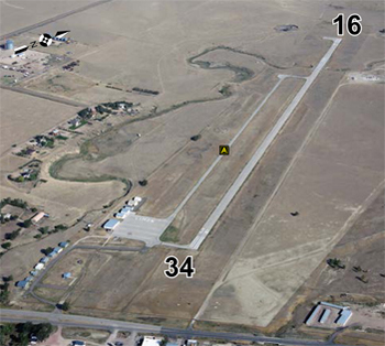
| LIMON MUNI LIMON CO |
| |
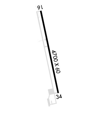
| Lat: N 3916.5 Long: W 10340.0 Elev: 5374 Var: -11 Longest Runway: 4700 | ||
| AWOS: 121.12 CTAF: 122.9 | ||
| ||||||
| ||||||
|
| Rwy | Rwy | |||||||
| 4700x60 | 4700' | 4700x60 | 4700' | |||||
| Runway ID | Single Wheel | Double Wheel | Double Tandem Wheel | Dual Double Wheel |
| 16/34 | 12,500 | N/A | N/A | N/A |
| These numbers are Advisory and are not limits. The Airport Manager should have more accurate Weight Limits | ||||
| FltPlan does not have IFR approach charts available for KLIC. |
 Airport Diagram might not be current. | |
| Facility Name: | LIMON MUNI |
| City Name: | LIMON |
| County: | LINCOLN |
| State abbrev: | CO |
| State Name: | COLORADO |
| Ownership: | PUBLICLY OWNED |
| Use: | OPEN TO THE PUBLIC |
| Owner's Name: | TOWN OF LIMON |
| Address: | TOWN HALL, BOX 9 |
| LIMON, CO 80828 | |
| Owner's Phone: | 719-775-2346 |
| Manager's Name: | DAVE STONE |
| Address: | TOWN OF LIMON, BOX 9 |
| LIMON, CO 80828 | |
| Phone: | 719-775-2346 |
| FAA Region: | NORTHWEST MOUNTAIN |
| FAA Field Office: | DEN |
| Date | Sunrise | Sunset |
|---|---|---|
| 09/24/21 Friday | 6:44 | 18:49 |
| 09/25/21 Saturday | 6:45 | 18:47 |
| 09/26/21 Sunday | 6:46 | 18:46 |
| 09/27/21 Monday | 6:47 | 18:44 |
| 09/28/21 Tuesday | 6:48 | 18:42 |
| 09/29/21 Wednesday | 6:49 | 18:41 |
| 09/30/21 Thursday | 6:50 | 18:39 |
| 10/01/21 Friday | 6:51 | 18:38 |
| 10/02/21 Saturday | 6:51 | 18:36 |
| 10/03/21 Sunday | 6:52 | 18:34 |
| 10/04/21 Monday | 6:53 | 18:33 |
| 10/05/21 Tuesday | 6:54 | 18:31 |
| 10/06/21 Wednesday | 6:55 | 18:30 |
| 10/07/21 Thursday | 6:56 | 18:28 |
| Airport Attendance Schedule | UNATTENDED |
| Airport Status | OPERATIONAL (This Status can change at any time - please check NOTAMS) |
| Airport Lighting Schedule | ACTVT MIRL RY 16/34 & PAPI RYS 16 & 34 - CTAF. |
| Airport Storage Available | Tie Downs |
| Extra Services Available | Flight Instruction |
| Wind Indicator | YES - (unlit) |
| Control Tower | NO |
| CTAF Frequency | 122.900 |
| Unicom Frequency | |
| Rotating Beacon Color | CLEAR-GREEN (Light Land Airport) |
| Segmented Circle | YES |
| Landing Fee | NO |
| Airport Inspected | STATE - performed by STATE AERONAUTICAL PERSONNEL |
| Inspection Date | 09/17/2018 |
| Type of Fuel Available | Grade 100LL; -1024 HR 100LL AVBL WITH CREDIT CARD. |
| Airframe Repair Service | MINOR |
| Power Plant Repair Service | MINOR |
| Latitude | N3916.5 |
| Longitude | W10340.0 (ESTIMATED) |
| Arpt Elevation | 5374ft (SURVEYED) |
| Magnetic Variation | 11E |
| 1 miles NE | of LIMON |
| Traffic Pattern Altitude | |
| Sectional Chart | WICHITA |
| Operations (Reported) | Yearly | Avg. Daily |
|---|---|---|
| General Aviation Transient | 2965 | 8 |
| General Aviation Local | 2965 | 8 |
| Air Taxi | 0 | 0 |
| Commerical | 0 | 0 |
| Commuter | 0 | 0 |
| Military | 70 | 0 |
| Aircraft based on Field | |
|---|---|
| General Aviation Singles | 16 |
| General Aviation Multi | 1 |
| Jet Aircraft | 0 |
| General Aviation Helicopters | 0 |
| Military Aircraft | 0 |
| Gliders | 0 |
| Ultralights | 0 |
| FSS on field | NO |
| FSS tie-in | DENVER |
| FSS Phone | 1-800-WX-BRIEF |
| Who issues Notams | LIC |
| Notam D service at airport | YES |
| ARTCC Name | DENVER |
| Airport Certification | |
| Aircraft Rescue & Firefighting Index | None |
| Airport of Entry | No |
| Custom Landing Rights | No |
| Joint Civil/Military | No |
| Military Landing rights | No |
| NATIONAL PLAN OF INTEGRATED AIRPORT SYSTEMS (NPIAS) |
| GRANT AGREEMENTS UNDER FAAP/ADAP/AIP |
| ASSURANCES PURSUANT TO TITLE VI, CIVIL RIGHTS ACT OF 1964 |
| UNCONTROLLED VEHICLE ACCESS TO FIELD. |
| TWY MARKED WITH BLUE REFLECTORS. |
| DEER ON & INVOF AIRPORT. |
| BE ALERT; INTENSIVE USAF STUDENT TRAINING IN VICINITY OF COLORADO SPRINGS & PUEBLO COLORADO. |
| RY 34 +18 FT ROAD 820 FT FM THLD OB; +4 FT FENCE 785 FT FM THLD OB; +22 FT SIGN 918 FT FM RY END ON CNTRLN; +45 FT TREES 1430 FT FM RY END OB; +51 FT TANK 1455 FT FM THLD 150 RIGHT OF CNTRLN. |
| FOR CD IF UNA TO CTC ON FSS FREQ, CTC DENVER ARTCC AT 303-651-4257. |
| RWY 16/3 4 RY 16 HAS 3000 FT TWY LEADING IN TO THE SOUTH END. |
| Runway: 16 | Runway: 34 | ||
| Mag heading: | 158° | Mag heading: | 338° |
| Rwy Slope: | -.55% Down | Rwy Slope: | .55% Up |
| Approach: | Approach: | ||
| Pattern: | Left Traffic | Pattern: | Left Traffic |
| Markings: | BASIC | Markings: | BASIC |
| Marking Condition: | GOOD | Marking Condition: | GOOD |
| Arresting Dev: | Arresting Dev: | ||
| Lat & Long: | N3916.9 W10340.0 | Lat. & Long.: | N3916.1 W10339.9 |
| Elev: | 5374.4 ft. MSL | Elev: | 5348.6 ft. MSL |
| TCH: | 39 ft. AGL | TCH: | 39 ft. AGL |
| Visual Glide Path: | 3.00 degrees | Visual Glide Path: | 3.00 degrees |
| Displaced Threshold: | No | Displaced Threshold: | No |
| Touchdown Zone: | YES | Touchdown Zone: | YES |
| Touchdown Elev.: | 5374.4 feet | Touchdown Elev.: | 5365.0 feet |
| Visual Glide Slope: | 2-Light PAPI on LEFT side of Runway | Visual Glide Slope: | 2-Light PAPI on LEFT side of Runway |
| RVR Equipment: | RVR Equipment: | ||
| RVV Equipment: | NO | RVV Equipment: | NO |
| Approach Lights: | Approach Lights: | ||
| REIL: | NO | REIL: | NO |
| Centerline Lights: | NO | Centerline Lights: | NO |
| Touchdown lights: | NO | Touchdown lights: | NO |
| Runway Category: | Runway with a Visual Approach | Runway Category: | Runway with a Visual Approach |
| Declared Distances: | Declared Distances: | ||
| Obstructions: | PLINE | Obstructions: | TREES |
| Marked: | NOT Marked/Lighted | Marked: | NOT Marked/Lighted |
| Clearance slope: | 47:1 | Clearance slope: | 22:1 |
| Obstruction height: | 34 feet AGL | Obstruction height: | 33 feet AGL |
| Dist. from runway: | 1800 feet | Dist. from runway: | 915 feet |
| Centerline offset: | B | Centerline offset: | 163 feet right of centerline |
| Comments: | Comments: |
Thanks for using FltPlan.com
all rights reserved © 1999-2021 by Flight Plan LLC