
| LA JUNTA MUNI LA JUNTA CO |
| |
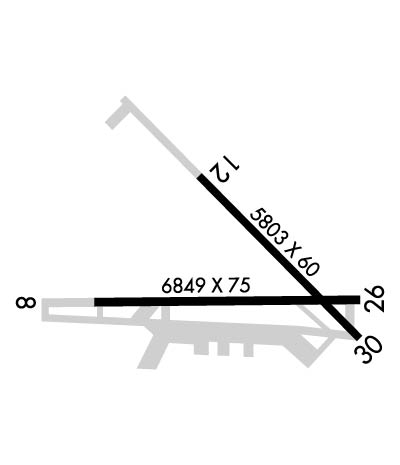
| Lat: N 3803.0 Long: W 10330.6 Elev: 4229 Var: -09 Longest Runway: 6849 | ||
| AWOS: 135.52 CTAF: 123.0 | ||
| |||||||||||||||||||||||
| |||||||||||||||||||||||
| |||||||||||||||||||||||
| Rwy | Rwy | |||||||
| 6849x75 | 6849' | 6849x75 | 6849' | |||||
| 5803x60 | 5803' | 5803x60 | 5803' | |||||
| Runway ID | Single Wheel | Double Wheel | Double Tandem Wheel | Dual Double Wheel |
| 08/26 | 30,000 | 50,000 | 90,000 | N/A |
| 12/30 | 50,000 | 65,000 | 100,000 | N/A |
| H1 | N/A | N/A | N/A | N/A |
| These numbers are Advisory and are not limits. The Airport Manager should have more accurate Weight Limits | ||||
 Airport Diagram might not be current. | |
| Facility Name: | LA JUNTA MUNI |
| City Name: | LA JUNTA |
| County: | OTERO |
| State abbrev: | CO |
| State Name: | COLORADO |
| Ownership: | PUBLICLY OWNED |
| Use: | OPEN TO THE PUBLIC |
| Owner's Name: | CITY OF LA JUNTA |
| Address: | PO BOX 489 |
| LA JUNTA, CO 81050 | |
| Owner's Phone: | 719-384-8407 |
| Manager's Name: | BROCK HINKHOUSE; ALT CTC FBO 719-384-8407. |
| Address: | P O BOX 489 |
| LA JUNTA, CO 81050 | |
| Phone: | 719-363-1253 |
| FAA Region: | NORTHWEST MOUNTAIN |
| FAA Field Office: | DEN |
| Date | Sunrise | Sunset |
|---|---|---|
| 06/08/26 Monday | 5:31 | 20:15 |
| 06/09/26 Tuesday | 5:31 | 20:16 |
| 06/10/26 Wednesday | 5:31 | 20:16 |
| 06/11/26 Thursday | 5:31 | 20:17 |
| 06/12/26 Friday | 5:31 | 20:17 |
| 06/13/26 Saturday | 5:31 | 20:18 |
| 06/14/26 Sunday | 5:31 | 20:18 |
| 06/15/26 Monday | 5:31 | 20:18 |
| 06/16/26 Tuesday | 5:31 | 20:19 |
| 06/17/26 Wednesday | 5:31 | 20:19 |
| 06/18/26 Thursday | 5:31 | 20:19 |
| 06/19/26 Friday | 5:31 | 20:20 |
| 06/20/26 Saturday | 5:31 | 20:20 |
| 06/21/26 Sunday | 5:31 | 20:20 |
| Airport Attendance Schedule | 7 Days A Week 0700-1600 |
| Airport Status | OPERATIONAL (This Status can change at any time - please check NOTAMS) |
| Airport Lighting Schedule | ACTVT REIL RWY 08 & 26; PAPI RWY 08 & 26; MIRL RWY 08/26 - CTAF. |
| Airport Storage Available | Tie Downs, Hanger |
| Extra Services Available | Crop Dusting, Air Ambulance, Flight Instruction |
| Wind Indicator | YES - (lighted) |
| Control Tower | NO |
| CTAF Frequency | 123.000 |
| Unicom Frequency | 123.000 |
| Rotating Beacon Color | WG |
| Segmented Circle | YES |
| Landing Fee | NO |
| Airport Inspected | STATE - performed by STATE AERONAUTICAL PERSONNEL |
| Inspection Date | 06/13/2023 |
| Type of Fuel Available | Grade 100LL, JET A (freeze point -40C) |
| Airframe Repair Service | None |
| Power Plant Repair Service | None |
| Latitude | N3803.0 |
| Longitude | W10330.6 (ESTIMATED) |
| Arpt Elevation | 4228ft (SURVEYED) |
| Magnetic Variation | 09E |
| 3 miles N | of LA JUNTA |
| Traffic Pattern Altitude | |
| Sectional Chart | WICHITA |
| Operations (Reported) | Yearly | Avg. Daily |
|---|---|---|
| General Aviation Transient | 0 | 0 |
| General Aviation Local | 0 | 0 |
| Air Taxi | 0 | 0 |
| Commerical | 0 | 0 |
| Commuter | 0 | 0 |
| Military | 0 | 0 |
| Aircraft based on Field | |
|---|---|
| General Aviation Singles | 0 |
| General Aviation Multi | 0 |
| Jet Aircraft | 0 |
| General Aviation Helicopters | 0 |
| Military Aircraft | 0 |
| Gliders | 0 |
| Ultralights | 0 |
| FSS on field | NO |
| FSS tie-in | DENVER |
| FSS Phone | 1-800-WX-BRIEF |
| Who issues Notams | LHX |
| Notam D service at airport | YES |
| ARTCC Name | DENVER |
| Airport Certification | |
| Aircraft Rescue & Firefighting Index | None |
| Airport of Entry | No |
| Custom Landing Rights | No |
| Joint Civil/Military | No |
| Military Landing rights | YES |
| NATIONAL PLAN OF INTEGRATED AIRPORT SYSTEMS (NPIAS) |
| GRANT AGREEMENTS UNDER FAAP/ADAP/AIP |
| SURPLUS PROPERTY AGREEMENT UNDER PUBLIC LAW 289 |
| ASSURANCES PURSUANT TO TITLE VI, CIVIL RIGHTS ACT OF 1964 |
| THIS AIRPORT HAS BEEN SURVEYED BY THE NATIONAL GEODETIC SURVEY. |
| ANTELOPE ON & INVOF ARPT. |
| HVY AGRICULTURAL OPNS DURG SUMMER MONTHS. |
| RWY 12/30 HAS LOOSE ASPH MTRL IN PRIM SFC WEST SIDE OF RWY FULL LENGTH. |
| RWY 12/30 EDGE UNDEFINED. |
| BE ALERT; INTENSIVE USAF STUDENT TRNG INVOF COLORADO SPRINGS & PUEBLO COLORADO. |
| SELF SERVE JET-A NOT AVAIL. |
| FOR CD CTC DENVER ARTCC AT 303-651-4257. |
| RWY 12/3 0 RWY SFC RAVELING WITH FOD POTENTIAL. |
Airport Communications & Frequencies:
| |||||||||
| Runway: 08 | Runway: 26 | ||
| Mag heading: | 81° | Mag heading: | 261° |
| Rwy Slope: | -1.09% Down | Rwy Slope: | 1.09% Up |
| Approach: | Approach: | ||
| Pattern: | Left Traffic | Pattern: | Left Traffic |
| Markings: | NONPRECISION INSTRUMENT | Markings: | NONPRECISION INSTRUMENT |
| Marking Condition: | GOOD | Marking Condition: | GOOD |
| Arresting Dev: | Arresting Dev: | ||
| Lat & Long: | N3802.9 W10331.4 | Lat. & Long.: | N3802.9 W10330.0 |
| Elev: | 4228.6 ft. MSL | Elev: | 4153.8 ft. MSL |
| TCH: | 45 ft. AGL | TCH: | 43 ft. AGL |
| Visual Glide Path: | 3.00 degrees | Visual Glide Path: | 3.00 degrees |
| Displaced Threshold: | No | Displaced Threshold: | No |
| Touchdown Zone: | YES | Touchdown Zone: | YES |
| Touchdown Elev.: | 4228.6 feet | Touchdown Elev.: | 4187.5 feet |
| Visual Glide Slope: | 2-Light PAPI on LEFT side of Runway | Visual Glide Slope: | 2-Light PAPI on LEFT side of Runway |
| RVR Equipment: | RVR Equipment: | ||
| RVV Equipment: | NO | RVV Equipment: | NO |
| Approach Lights: | Approach Lights: | ||
| REIL: | YES | REIL: | YES |
| Centerline Lights: | NO | Centerline Lights: | NO |
| Touchdown lights: | NO | Touchdown lights: | NO |
| Runway Category: | Runway with a Non-precision Approach having visibility minimums greater than 3/4 mile | Runway Category: | Runway with a Visual Approach |
| Declared Distances: | Declared Distances: | ||
| Obstructions: | ROAD | Obstructions: | |
| Marked: | NOT Marked/Lighted | Marked: | |
| Clearance slope: | 41:1 | Clearance slope: | 50:1 |
| Obstruction height: | 28 feet AGL | Obstruction height: | |
| Dist. from runway: | 1351 feet | Dist. from runway: | |
| Centerline offset: | 8 right of centerline | Centerline offset: | |
| Comments: | Comments: |
| Runway: 12 | Runway: 30 | ||
| Mag heading: | 126° | Mag heading: | 306° |
| Rwy Slope: | -.48% Down | Rwy Slope: | .48% Up |
| Approach: | Approach: | ||
| Pattern: | Left Traffic | Pattern: | Left Traffic |
| Markings: | BASIC | Markings: | BASIC |
| Marking Condition: | FAIR | Marking Condition: | FAIR |
| Arresting Dev: | Arresting Dev: | ||
| Lat & Long: | N3803.5 W10330.9 | Lat. & Long.: | N3802.8 W10330.0 |
| Elev: | 4185.7 ft. MSL | Elev: | 4157.9 ft. MSL |
| TCH: | TCH: | ||
| Visual Glide Path: | Visual Glide Path: | ||
| Displaced Threshold: | No | Displaced Threshold: | No |
| Touchdown Zone: | YES | Touchdown Zone: | YES |
| Touchdown Elev.: | 4185.7 feet | Touchdown Elev.: | 4178.8 feet |
| Visual Glide Slope: | Visual Glide Slope: | ||
| RVR Equipment: | RVR Equipment: | ||
| RVV Equipment: | NO | RVV Equipment: | NO |
| Approach Lights: | Approach Lights: | ||
| REIL: | NO | REIL: | NO |
| Centerline Lights: | NO | Centerline Lights: | NO |
| Touchdown lights: | NO | Touchdown lights: | NO |
| Runway Category: | Runway with a Visual Approach | Runway Category: | Runway with a Visual Approach |
| Declared Distances: | Declared Distances: |
Thanks for using FltPlan.com
all rights reserved © 1999-2026 by Flight Plan LLC

